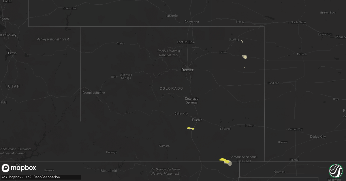
Hail Map in Colorado on August 29, 2020
Get this storm
August 29 map
$229
one time, instant access
Download today. No call, no setup
Keep the $229
Bought the map and want the full workflow? Apply the entire $229 to a subscription within 7 days. None of it is wasted.
Every map, not just this one
This buys you this map. Subscription and you get every map we run, in the markets you choose from a few cities to whole states to nationwide. Plus real-time alerts the moment a storm fires.
Contact data
Name, contact info, occupancy, even credit band for addresses in the footprint. You go from where it hit to who to call.
Become the source they trust
Unlimited branding weather history reports on demand. You already have the documented answer ready for the property owner, and you are the one who showed up with it.
Property data and RoofTrace estimates
Pull up any address you have got, its value and the exact code rules for that jurisdiction, straight from One Click Code. Then RoofTrace estimates the squares, pitch, and roof value, priced the way you price.
Storm reports in Colorado
Colorado
| Date | Description |
|---|---|
| 08/29/20204:54 PM CDT | Asos station kcag craig-moffat county airport. |
| 08/29/20203:23 PM CDT | I-25 and mm77. One inch hail reported. |
| 08/29/202012:18 AM CDT | At 518 PM CDT, a severe thunderstorm was located 6 miles north of Seneca, or 18 miles north of Clayton, moving east at 50 mph. HAZARD...60 mph wind gusts and nickel size hail. SOURCE...Radar indicated. IMPACT...Minor damage to roofs, siding, and trees is possible. Locations impacted include... Boise City, Keyes, Kenton, Wheeless, Black Mesa Park and Felt. |
| 08/28/202010:48 PM CDT | At 348 PM MDT, a severe thunderstorm was located 17 miles southwest of Kim, or 25 miles northeast of Des Moines, moving east at 15 mph. HAZARD...60 mph wind gusts and half dollar size hail. SOURCE...Radar indicated. IMPACT...Hail damage to vehicles is expected. Expect wind damage to roofs, siding, and trees. This severe thunderstorm will remain over mainly rural areas of southeastern Las Animas County. |
| 08/28/202010:43 PM CDT | At 343 PM MDT, a severe thunderstorm was located 19 miles east of Branson, or 22 miles northeast of Des Moines, moving southeast at 15 mph. HAZARD...60 mph wind gusts and quarter size hail. SOURCE...Radar indicated. IMPACT...Hail damage to vehicles is expected. Expect wind damage to roofs, siding, and trees. This severe thunderstorm will remain over mainly rural areas of north central Union County. |
| 08/28/202010:22 PM CDT | At 322 PM MDT, a severe thunderstorm was located 10 miles southwest of Meeker, or 43 miles northwest of Glenwood Springs, moving east at 30 mph. HAZARD...60 mph wind gusts and penny size hail. SOURCE...Radar indicated. IMPACT...Expect damage to roofs, siding, and trees. Locations impacted include... Meeker and Rio Blanco. This includes the following highways... Colorado 13 between mile markers 17 and 50. Colorado 64 between mile markers 67 and 73. |
| 08/28/202010:00 PM CDT | At 300 PM MDT, a severe thunderstorm was located 10 miles east of Branson, or 21 miles north of Des Moines, moving east at 10 mph. HAZARD...60 mph wind gusts and half dollar size hail. SOURCE...Radar indicated. IMPACT...Hail damage to vehicles is expected. Expect wind damage to roofs, siding, and trees. This severe thunderstorm will remain over mainly rural areas of southeastern Las Animas County. |
| 08/28/20209:59 PM CDT | At 259 PM MDT, a severe thunderstorm was located 14 miles west of Meeker, or 45 miles southwest of Craig, moving east at 35 mph. HAZARD...60 mph wind gusts and penny size hail. SOURCE...Radar indicated. IMPACT...Expect damage to roofs, siding, and trees. Locations impacted include... Meeker.This includes the following highways... Colorado 13 between mile markers 29 and 59. Colorado 64 between mile markers 48 and 73. |
| 08/28/20209:28 PM CDT | At 228 PM MDT, a severe thunderstorm was located 17 miles northeast of Greenhorn Mountain, or 20 miles south of Pueblo, moving east at 25 mph. HAZARD...60 mph wind gusts and quarter size hail. SOURCE...Radar indicated. IMPACT...Hail damage to vehicles is expected. Expect wind damage to roofs, siding, and trees. Locations impacted include... Colorado City. |
| 08/28/20208:45 PM CDT | At 145 PM MDT, a severe thunderstorm was located 9 miles north of Greenhorn Mountain, or 11 miles southeast of Junkins Burn Scar, moving east at 10 mph. HAZARD...60 mph wind gusts and quarter size hail. SOURCE...Radar indicated. IMPACT...Hail damage to vehicles is expected. Expect wind damage to roofs, siding, and trees. Locations impacted include... San Isabel, Beulah and Colorado City. |
All States Impacted by Hail Map on August 29, 2020
Cities Impacted by Hail Map on August 29, 2020
- Chester, AR
- Weleetka, OK
- Norman, AR
- Mount Ida, AR
- Huntsville, AR
- Memphis, TX
- Hedley, TX
- Wellington, TX
- Tulia, TX
- Paris, TX
- Lake Creek, TX
- Cooper, TX
- Masterson, TX
- Mound Valley, KS
- Independence, KS
- Dennis, KS
- Parsons, KS
- Oswego, KS
- Altamont, KS
- Cherryvale, KS
- Tubac, AZ
- Booneville, AR
- Mansfield, AR
- Waldron, AR
- Lane, OK
- Atoka, OK
- Bennington, OK
- Panhandle, TX
- Groom, TX
- Boswell, OK
- Soper, OK
- Durant, OK
- Bokchito, OK
- Caddo, OK
- Canal Point, FL
- Paducah, TX
- Childress, TX
- Lance Creek, WY
- Douglas, WY
- Mena, AR
- Cave City, AR
- Sulphur Rock, AR
- Fort Worth, TX
- Petty, TX
- Roxton, TX
- Honey Grove, TX
- Upton, WY
- Moorcroft, WY
- Cabool, MO
- Fort Smith, AR
- Tell, TX
- Quanah, TX
- Lawton, OK
- Broken Bow, OK
- Cache, OK
- Faxon, OK
- Galway, NY
- Quitaque, TX
- Happy, TX
- Clarendon, TX
- Claude, TX
- Silverton, TX
- Otis, CO
- Yuma, CO
- Amsterdam, NY
- Gloversville, NY
- Johnstown, NY
- Broadalbin, NY
- Sells, AZ
- Antlers, OK
- Copan, OK
- Havana, KS
- Tyro, KS
- Wann, OK
- Coffeyville, KS
- Caney, KS
- Maynard, AR
- Scotland, AR
- Gunter, TX
- Tioga, TX
- Howe, TX
- Evening Shade, AR
- Horseshoe Bend, AR
- Ash Flat, AR
- Mountain Grove, MO
- Rogers, AR
- Hindsville, AR
- Schaghticoke, NY
- Pueblo, CO
- Hereford, TX
- Caddo Gap, AR
- Hugo, OK
- Smithville, AR
- Poughkeepsie, AR
- Franklin, AR
- Gould, OK
- Fort Towson, OK
- Rufe, OK
- Ringold, OK
- Bexar, AR
- Salem, AR
- Pocola, OK
- Cameron, OK
- Hackett, AR
- Walnut Ridge, AR
- Swifton, AR
- Cash, AR
- Anderson, MO
- Goodman, MO
- Spiro, OK
- Muldrow, OK
- Buckeye, AZ
- Wentworth, MO
- Mason, TN
- Rhome, TX
- Amarillo, TX
- Stanton, TN
- Noel, MO
- Sundance, WY
- Arthur City, TX
- Folsom, NM
- Branson, CO
- Grenville, NM
- Powderly, TX
- Newcastle, WY
- Congress, AZ
- Arcadia, KS
- Mindenmines, MO
- Liberal, MO
- England, AR
- Wister, OK
- Hodgen, OK
- Howe, OK
- Heavener, OK
- Smithville, OK
- Hatfield, AR
- Poteau, OK
- Pattonville, TX
- Pocahontas, AR
- Black Rock, AR
- Portia, AR
- Powhatan, AR
- Sedan, KS
- Lindsay, OK
- Welch, OK
- North Little Rock, AR
- Nashoba, OK
- Honobia, OK
- Beulah, CO
- Rye, CO
- Colorado City, CO
- Talihina, OK
- Muse, OK
- Whitesboro, OK
- Lamar, MO
- Bronaugh, MO
- Arma, KS
- Rapid City, SD
- Bee Branch, AR
- Vega, TX
- Azle, TX
- Elk City, KS
- Vian, OK
- Sallisaw, OK
- Cord, AR
- Saffell, AR
- Billings, MO
- Clever, MO
- Crane, MO
- Nixa, MO
- Greenwood, AR
- Clayton, OK
- Moyers, OK
- Dearing, KS
- S Coffeyville, OK
- Lenapah, OK
- Magazine, AR
- Boles, AR
- Alicia, AR
- Arlington, TN
- Eads, TN
- Everton, AR
- Harrison, AR
- Sumner, TX
- Brookston, TX
- Sherwood, AR
- Little Rock, AR
- Elkins, AR
- Channing, TX
- Houston, AR
- Bagwell, TX
- Valliant, OK
- Clarksville, TX
- Fleming, CO
- Turkey, TX
- Holdenville, OK
- Atwood, OK
- Dalhart, TX
- Lynn, AR
- Strawberry, AR
- Fultonville, NY
- Quapaw, OK
- Stigler, OK
- Huntington, AR
- Doniphan, MO
- Elizabeth, AR
- Viola, AR
- Wanette, OK
- Canyon, TX
- Hartford, AR
- Midland, AR
- Arkoma, OK
- Rio Rico, AZ
- Pilot Point, TX
- Chillicothe, TX
- Wilburton, OK
- Red Oak, OK
- Fletcher, OK
- Santa Fe, NM
- Mountainburg, AR
- Winslow, AR
- Bartlett, KS
- Hopkinsville, KY
- Leslie, AR
- Delaware, OK
- Vinita, OK
- Quincy, MO
- Henryetta, OK
- Deadwood, SD
- Oxford, AR
- Corona, NM
- Keller, TX
- Akron, CO
- Henderson, AR
- Wideman, AR
- Gepp, AR
- Dolph, AR
- Hardy, AR
- Wiseman, AR
- Haslet, TX
- Walnut, KS
- McCrory, AR
- Pencil Bluff, AR
- Sims, AR
- Oden, AR
- Batesville, AR
- Charlotte, AR
- Delaplaine, AR
- Brownsville, TN
- Rush Springs, OK
- Clermont, FL
- Groveland, FL
- Cumberland Furnace, TN
- Cumberland City, TN
- Vanleer, TN
- Hagarville, AR
- Sulphur Bluff, TX
- Dike, TX
- North Richland Hills, TX
- Dodson, TX
- Hollis, OK
- Wright City, OK
- Haltom City, TX
- Marshall, AR
- Saint Joe, AR
- Bradley, OK
- Jerico Springs, MO
- Lockwood, MO
- Cove, AR
- Watson, OK
- Clayton, NM
- Judsonia, AR
- Palmyra, TN
- Snow, OK
- Wyandotte, OK
- Miami, OK
- Wickes, AR
- Koshkonong, MO
- Alton, MO
- Brandsville, MO
- West Plains, MO
- Council Hill, OK
- Valley Falls, NY
- Stillwater, NY
- Alpena, AR
- Searcy, AR
- Bokoshe, OK
- Shady Point, OK
- Mulberry, KS
- Jonesboro, AR
- Bethel, OK
- Umpire, AR
- Jacksonville, AR
- Scott, AR
- Lonoke, AR
- Niotaze, KS
- Clinton, AR
- Lead, SD
- Hill City, SD
- Scranton, AR
- Hartman, AR
- Clarksville, AR
- Des Arc, AR
- Springer, NM
- Lavaca, AR
- Barling, AR
- Tumacacori, AZ
- Green Forest, AR
- Success, AR
- Warm Springs, AR
- Norwood, MO
- Stockton, MO
- Maud, OK
- Justin, TX
- Ponder, TX
- Baxter Springs, KS
- Clifton, TN
- Vandervoort, AR
- Telephone, TX
- Caney, OK
- Union City, TN
- Troy, TN
- Galesburg, KS
- Prescott, AZ
- Saint Paul, KS
- Lakeview, TX
- Columbus, KS
- Portageville, MO
- Marston, MO
- Lamar, AR
- Geronimo, OK
- Neodesha, KS
- Troy, NY
- Westphalia, KS
- Alma, AR
- Mulberry, AR
- Branch, AR
- Charleston, AR
- Lockesburg, AR
- Dierks, AR
- De Queen, AR
- Tuckerman, AR
- Aurora, MO
- Marionville, MO
- Mansfield, MO
- Conway, AR
- Mayflower, AR
- Bogata, TX
- Alzada, MT
- Vilonia, AR
- Cotton Plant, AR
- Fayetteville, AR
- Boyd, TX
- Springtown, TX
- Weatherford, TX
- Fredonia, KS
- Wildorado, TX
- Osceola, MO
- Liberty, KS
- Raton, NM
- Tiptonville, TN
- Indian Mound, TN
- Ripley, TN
- Cambridge, MD
- Church Creek, MD
- Henrietta, TX
- Temple, OK
- Randlett, OK
- Grandfield, OK
- Terral, OK
- Ringling, OK
- Burkburnett, TX
- Byers, TX
- Petrolia, TX
- Frederick, OK
- Loveland, OK
- Sheppard Afb, TX
- Hastings, OK
- Comanche, OK
- Devol, OK
- Ryan, OK
- Iowa Park, TX
- Waurika, OK
- Wichita Falls, TX
- Walters, OK
- Duncan, OK
- Burneyville, OK
- Plainview, AR
- Glenwood, AR
- Nashville, AR
- Newhope, AR
- Kirby, AR
- Delight, AR
- McCaskill, AR
- Murfreesboro, AR
- Langley, AR
- Amity, AR
- Story, AR
- Grannis, AR
- Keo, AR
- Hickory Ridge, AR
- Wynne, AR
- Davenport, NY
- East Meredith, NY
- Davenport Center, NY
- Averill Park, NY
- Sand Lake, NY
- Wynantskill, NY
- West Sand Lake, NY
- Newark, TX
- Texline, TX
- Ash Grove, MO
- Chanute, KS
- Thayer, KS
- Macomb, MO
- Fair Grove, MO
- Walnut Grove, MO
- Seymour, MO
- Pittsburg, KS
- Springfield, MO
- Golden City, MO
- Everton, MO
- Marshfield, MO
- McCune, KS
- Frontenac, KS
- Dadeville, MO
- Weir, KS
- Girard, KS
- Willard, MO
- Greenfield, MO
- Altoona, KS
- Asbury, MO
- South Greenfield, MO
- Brighton, MO
- Morrisville, MO
- Carthage, MO
- Erie, KS
- Strafford, MO
- Pleasant Hope, MO
- Franklin, KS
- Fordland, MO
- Oronogo, MO
- Rogersville, MO
- Jasper, MO
- Cherokee, KS
- Opolis, KS
- Pampa, TX
- White Deer, TX
- Caputa, SD


