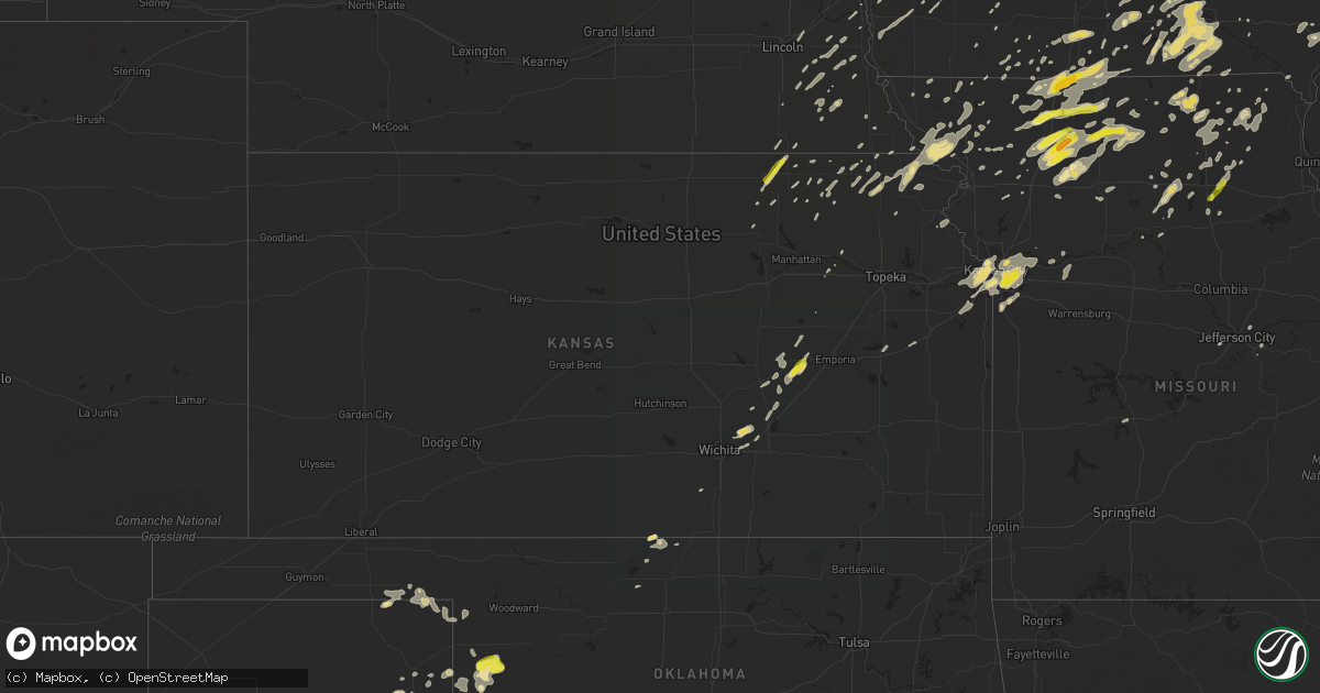
Hail Map in Kansas on August 28, 2018
Get this storm
August 28 map
$229
one time, instant access
Download today. No call, no setup
Keep the $229
Bought the map and want the full workflow? Apply the entire $229 to a subscription within 7 days. None of it is wasted.
Every map, not just this one
This buys you this map. Subscription and you get every map we run, in the markets you choose from a few cities to whole states to nationwide. Plus real-time alerts the moment a storm fires.
Contact data
Name, contact info, occupancy, even credit band for addresses in the footprint. You go from where it hit to who to call.
Become the source they trust
Unlimited branding weather history reports on demand. You already have the documented answer ready for the property owner, and you are the one who showed up with it.
Property data and RoofTrace estimates
Pull up any address you have got, its value and the exact code rules for that jurisdiction, straight from One Click Code. Then RoofTrace estimates the squares, pitch, and roof value, priced the way you price.
Storm reports in Kansas
Kansas
| Date | Description |
|---|---|
| 08/28/20185:15 PM CDT | Broken 4 inch diameter limb in residential neighborhood. |
| 08/28/20185:06 PM CDT | Numerous branches down and some power poles down in shawnee. Time estimated via radar. |
| 08/28/20181:01 PM CDT | A local report indicates 1.00 inch wind near 4 W OKETO |
| 08/28/201812:50 PM CDT | A local report indicates 1.00 inch wind near 2 E BREMEN |
| 08/28/20189:54 AM CDT | Wind reducing visibity to zero with heavy rain. |
| 08/28/20189:49 AM CDT | A local report indicates 60 MPH wind near N COTTONWOOD FALLS |
| 08/28/20189:49 AM CDT | Leaves and twigs being stripped from trees. |
| 08/28/20189:25 AM CDT | Three large trees uprooted. Damage to a machine shed. Time estimated based on radar data. |
| 08/28/20189:15 AM CDT | Damage to roof of house. Siding torn off of another house. Barn roof partially torn off. Time estimated based on radar data. |
| 08/28/20187:41 AM CDT | At 1241 PM CDT, a severe thunderstorm was located 6 miles north of Barnes, moving northeast at 55 mph. HAZARD...60 mph wind gusts and quarter size hail. SOURCE...Radar indicated. IMPACT...Hail damage to vehicles is expected. Expect wind damage to roofs, siding, and trees. Locations impacted include... Marysville, Hanover, Oketo and Bremen. |
| 08/28/20184:27 AM CDT | At 926 AM CDT, a severe thunderstorm was located near Cottonwood Falls, moving northeast at 30 mph. HAZARD...60 mph wind gusts and half dollar size hail. SOURCE...Radar indicated. IMPACT...Hail damage to vehicles is expected. Expect wind damage to roofs, siding, and trees. Locations impacted include... Cottonwood Falls, Strong City, Bazaar, Elmdale, Matfield Green, Saffordville, Tallgrass Prairie and Tallgrass Prairie Preserve.This includes Interstate 35 between Mile Markers 108 and 115. |
| 08/28/201812:13 AM CDT | At 513 PM CDT, severe thunderstorms were located along a line extending from near Lake Waukomis to Prairie Village to near Spring Hill, moving east at 30 mph. HAZARD...60 mph wind gusts and quarter size hail. SOURCE...Radar indicated. IMPACT...Hail damage to vehicles is expected. Expect wind damage to roofs, siding, and trees. Locations impacted include... Kansas City, Overland Park, Olathe, Independence, Lee's Summit, Blue Springs, Lenexa, Leawood, Raytown, Liberty, Gladstone, Grandview, Belton, Prairie Village, Raymore, Grain Valley, Excelsior Springs, Merriam, Mission and Kearney.This includes the following highways... Interstate 70 in Missouri between mile markers 0 and 24. Interstate 70 in Kansas between mile markers 419 and 423. Interstate 35 in Missouri between mile markers 0 and 27. Interstate 35 in Kansas between mile markers 225 and 235. Interstate 29 between mile markers 0 and 8. Interstate 635 between mile markers 0 and 12. Interstate 470 between mile markers 0 and 16. Interstate 435 between mile markers 40 and 82. |
All States Impacted by Hail Map on August 28, 2018
Cities Impacted by Hail Map on August 28, 2018
- Harbor Beach, MI
- Ruth, MI
- Zion, IL
- Wadsworth, IL
- Waukegan, IL
- Gurnee, IL
- Kirkville, IA
- Floris, IA
- Moravia, IA
- Blakesburg, IA
- Chillicothe, IA
- Eddyville, IA
- Ottumwa, IA
- Drakesville, IA
- Moulton, IA
- Centerville, IA
- Albia, IA
- Bloomfield, IA
- Udell, IA
- Unionville, IA
- Mystic, IA
- Lyndon Station, WI
- Wisconsin Dells, WI
- Greenfield, IA
- Algona, IA
- West Bend, IA
- Whittemore, IA
- Ottosen, IA
- Waverly, IA
- Plainfield, IA
- Salisbury, MO
- Aurora, IL
- Cottonwood Falls, KS
- Pocahontas, IA
- Oshkosh, WI
- Allegan, MI
- Taylor Ridge, IL
- Milan, IL
- Aledo, IL
- Reynolds, IL
- Chariton, IA
- Knoxville, IA
- Melcher Dallas, IA
- Emerson, IA
- Orrick, MO
- Algoma, WI
- Sturgeon Bay, WI
- Miami, TX
- Canadian, TX
- Kansas City, KS
- Bremen, KS
- Offutt Afb, NE
- Booker, TX
- Follett, TX
- Balko, OK
- Darrouzett, TX
- Laverne, OK
- Maryville, MO
- West Union, IA
- La Crosse, WI
- La Crescent, MN
- Colwell, IA
- Charles City, IA
- Mount Carroll, IL
- Lanark, IL
- Weldon, IA
- Osceola, IA
- Humeston, IA
- Grand River, IA
- Van Wert, IA
- Iowa City, IA
- Coralville, IA
- Tiffin, IA
- Oxford, IA
- Parnell, IA
- North English, IA
- South English, IA
- Glenwood, IA
- Mount Pleasant, IA
- Brookfield, MO
- Marceline, MO
- Garner, IA
- Britt, IA
- Klemme, IA
- Black Creek, WI
- Eagle Grove, IA
- Badger, IA
- Vincent, IA
- Thor, IA
- Fort Dodge, IA
- Sterling, NE
- Fonda, IA
- Rolfe, IA
- Havelock, IA
- Palmer, IA
- Manson, IA
- Maple City, MI
- La Salle, IL
- Peru, IL
- Coal Valley, IL
- Medford, OK
- Dawn, MO
- Pelham, GA
- Newton, GA
- Camilla, GA
- Bethany, MO
- New Hampton, MO
- Hawkeye, IA
- Waucoma, IA
- Kansas City, MO
- Dakota City, IA
- Thornton, IA
- Lu Verne, IA
- Ridgeway, IA
- Forest City, IA
- Ventura, IA
- Bode, IA
- Woden, IA
- Marble Rock, IA
- Fredericksburg, IA
- Crystal Lake, IA
- Lawler, IA
- Renwick, IA
- Clear Lake, IA
- Rockford, IA
- Saint Lucas, IA
- New Hampton, IA
- Kanawha, IA
- Hardy, IA
- Corwith, IA
- Calmar, IA
- Nora Springs, IA
- Mason City, IA
- Swaledale, IA
- Ionia, IA
- Rudd, IA
- Meservey, IA
- Wesley, IA
- Sumner, IA
- Castalia, IA
- Ossian, IA
- Mallard, IA
- Livermore, IA
- Fort Atkinson, IA
- Goodell, IA
- Humboldt, IA
- Rockwell, IA
- Nashua, IA
- Galt, MO
- Trenton, MO
- Humphreys, MO
- Spickard, MO
- Kalona, IA
- Glidden, IA
- Nash, OK
- Wakita, OK
- Green Bay, WI
- Mount Ayr, IA
- Cordova, IL
- Camanche, IA
- De Witt, IA
- Low Moor, IA
- Walcott, IA
- Davenport, IA
- Dixon, IA
- Fenton, IL
- Clinton, IA
- Eldridge, IA
- Fulton, IL
- Le Claire, IA
- Stockton, IA
- Erie, IL
- Albany, IL
- Princeton, IA
- McCausland, IA
- Long Grove, IA
- Lamoni, IA
- Blythedale, MO
- Davis City, IA
- Cainsville, MO
- Eagleville, MO
- Cosby, MO
- Savannah, MO
- Polo, IL
- Oregon, IL
- Ravenwood, MO
- Plano, IA
- Manchester, OK
- Port Saint Joe, FL
- Lees Summit, MO
- Lineville, IA
- Leon, IA
- Allerton, IA
- West Branch, IA
- West Liberty, IA
- Waukon, IA
- Jolley, IA
- Sac City, IA
- Lytton, IA
- Melrose, IA
- Unionville, MO
- Greentop, MO
- Novinger, MO
- Glenwood, MO
- Kirksville, MO
- Worthington, MO
- Green Castle, MO
- Livonia, MO
- Queen City, MO
- Mission, KS
- Bonner Springs, KS
- Riverside, MO
- Lenexa, KS
- Shawnee, KS
- De Soto, KS
- Lovilia, IA
- Bussey, IA
- Robinson, KS
- Troy, KS
- Everest, KS
- Denton, KS
- Kendall, WI
- El Dorado, KS
- Burns, KS
- Leland, MI
- Lake Leelanau, MI
- Northport, MI
- Columbus, WI
- Hermitage, MO
- Saugatuck, MI
- Sugar Grove, IL
- Poy Sippi, WI
- Redgranite, WI
- Pine River, WI
- Lake View, IA
- Hamilton, MO
- Chillicothe, MO
- Lock Springs, MO
- Gallatin, MO
- Breckenridge, MO
- Jamesport, MO
- Leedey, OK
- Hammon, OK
- Danville, IA
- New London, IA
- Nebraska City, NE
- Dunbar, NE
- Otoe, NE
- Independence, MO
- Luray, MO
- Frankfort, KS
- Willis, TX
- Carroll, IA
- Sallis, MS
- Ridgeway, MO
- Bear Lake, MI
- Thompsonville, MI
- Copemish, MI
- Princeton, WI
- Montello, WI
- Plano, IL
- Big Rock, IL
- Tingley, IA
- Diagonal, IA
- Appleton, WI
- Rockwell City, IA
- Ogden, IA
- Woodward, IA
- Dawson, IA
- Perry, IA
- Bennett, IA
- Jackson, LA
- Ainsworth, IA
- Hanover, KS
- Barnes, KS
- Marysville, KS
- Palmyra, NE
- Avoca, NE
- Unadilla, NE
- Weeping Water, NE
- Syracuse, NE
- Shattuck, OK
- New Cambria, MO
- Pattonsburg, MO
- Coffey, MO
- Spring Hill, FL
- Wetmore, KS
- Powhattan, KS
- Fairview, KS
- Russell, IA
- New Waverly, TX
- Holland, MI
- Hamilton, MI
- Douglas, MI
- Fennville, MI
- Zeeland, MI
- Morrison, IL
- Orchard, IA
- Caledonia, MI
- Alto, MI
- Gorin, MO
- Hartford, MI
- Watervliet, MI
- Lawrence, MI
- Bangor, MI
- Avon, IL
- Gilson, IL
- London Mills, IL
- Saint Augustine, IL
- Abingdon, IL
- Berwick, IL
- Maquon, IL
- South Haven, MI
- Perryton, TX
- Jameson, MO
- Gilman City, MO
- Harpers Ferry, IA
- Baileyville, IL
- German Valley, IL
- Forreston, IL
- Shannon, IL
- Freeport, IL
- Ionia, MI
- Adams, NE
- Firth, NE
- Colquitt, GA
- Laurens, IA
- Whiting, KS
- Westboro, MO
- McIntosh, AL
- Leawood, KS
- Overland Park, KS
- Prairie Village, KS
- Princeton, MO
- Chicago, IL
- Clarence, MO
- Anabel, MO
- Macon, MO
- Liberty, MO
- Buckner, MO
- Olathe, KS
- Sibley, MO
- Blue Springs, MO
- West Salem, WI
- Crestview, FL
- Williamsburg, IA
- Webster, IA
- Keswick, IA
- South Amana, IA
- Postville, IA
- Leaf River, IL
- Rose Hill, IA
- Delta, IA
- What Cheer, IA
- Forest City, MO
- Maitland, MO
- White Cloud, KS
- Oregon, MO
- Fillmore, MO
- Mound City, MO
- Craig, MO
- Lowell, MI
- Ada, MI
- Greene, IA
- Griswold, IA
- Treynor, IA
- Prescott, IA
- Tallahassee, FL
- Oskaloosa, IA
- Bristol, IL
- Yorkville, IL
- Blair, NE
- Bennington, NE
- Omaha, NE
- Ellisville, IL
- Maysville, MO
- Mount Calvary, WI
- Malta, IL
- Lee, IL
- Ashton, IL
- Steward, IL
- Bucklin, MO
- Bangor, WI
- Coon Valley, WI
- Goff, KS
- Sabetha, KS
- Columbia, IA
- Lacona, IA
- New London, WI
- Hortonville, WI
- Casco, WI
- Luxemburg, WI
- Forestville, WI
- Saranac, MI
- Belding, MI
- King City, MO
- Oxford, WI
- Westfield, WI
- Grand Marsh, WI
- Arbela, MO
- Panhandle, TX
- White Deer, TX
- Gilmore City, IA
- Pickrell, NE
- Panama City, FL
- Wyoming, MI
- Stanhope, IA
- Jewell, IA
- Kamrar, IA
- Indianola, IA
- New Virginia, IA
- Kellerton, IA
- Lansing, IA
- Skidmore, MO
- Graham, MO
- Benton, KS
- Valley Center, KS
- Towanda, KS
- New Bloomfield, MO
- Tebbetts, MO
- Holts Summit, MO
- Montgomery, IL
- Franklin, TX
- Albany, MO
- McFall, MO
- Downing, MO
- Briscoe, TX
- Wheeler, TX
- Decorah, IA
- Elburn, IL
- New Sharon, IA
- Wymore, NE
- Odell, NE
- Falls City, NE
- Hiawatha, KS
- Greenleaf, KS
- Latimer, IA
- Hampton, IA
- Alexander, IA
- Marshalltown, IA
- Amboy, IL
- Dixon, IL
- Franklin Grove, IL
- Plattsmouth, NE
- Bellevue, NE
- Barnard, MO
- O'Brien, FL
- Mendota, IL
- West Brooklyn, IL
- Pella, IA
- Perry, FL
- Oketo, KS
- Chilton, WI
- Elroy, WI
- Mauston, WI
- Belmond, IA
- Clarion, IA
- Ames, IA
- Gilbert, IA
- Tecumseh, NE
- Steinauer, NE
- Skellytown, TX
- Neshkoro, WI
- Oneida, IL
- Victoria, IL
- Knoxville, IL
- Altona, IL
- Galesburg, IL
- Waterman, IL
- Hinckley, IL
- Green Lake, WI
- Mabel, MN
- Spring Grove, MN
- Atlantic, IA
- Green City, MO
- Mercer, MO
- Harmon, IL
- Horton, KS
- Netawaka, KS
- Highland, KS
- Bolckow, MO
- Grant City, MO
- Martinsville, MO
- Hatfield, MO
- La Farge, WI
- Slater, MO
- Miami, MO
- Cedar Point, KS
- Arlington, GA
- La Plata, MO
- Tarkio, MO
- Leonard, MO
- Tipton, IA
- Atalissa, IA
- Vail, IA
- Orient, IA
- Dexter, IA
- Lenox, IA
- New Franken, WI
- Murray, NE
- Osborn, MO
- Sigourney, IA
- Erick, OK
- Normangee, TX
- Altha, FL
- Lena, MS
- Carthage, MS
- Conesville, IA
- Columbus Junction, IA
- Nichols, IA
- Lone Tree, IA
- Lewis, IA
- Saint Marys, KS
- Cheyenne, OK
- Winneconne, WI
- Elkton, MI
- Pacific Junction, IA
- Malvern, IA
- Thurman, IA
- Tabor, IA
- Hastings, IA
- Wellman, IA
- Keota, IA
- Marengo, IA
- North Liberty, IA
- Moscow, IA
- Deep River, IA
- Barnes City, IA
- Riverside, IA
- Hills, IA
- Harper, IA
- Wilton, IA
- Washington, IA
- Homestead, IA
- Solon, IA
- Letts, IA
- Muscatine, IA
- Millersburg, IA
- Tomball, TX
- Wonewoc, WI
- Arnett, OK
- Shabbona, IL
- North Aurora, IL
- Mooseheart, IL
- Naperville, IL
- Dekalb, IL
- Oswego, IL
- Maple Park, IL
- Batavia, IL
- Guilford, MO
- Buckley, MI
- Kingsley, MI
- Tawas City, MI
- Missouri Valley, IA
- Harris, MO
- Pollock, MO
- Milan, MO
- Newtown, MO
- Orleans, MI
- Paxico, KS
- Edina, MO
- Rutledge, MO
- Batavia, IA
- Fairfield, IA
- Waverly, NE
- Lincoln, NE
- Sheffield, IL
- Mineral, IL
- Walnut, IL
- Annawan, IL
- Tampico, IL
- Clarksville, IA
- Shell Rock, IA
- Fremont, WI
- Lohrville, IA
- Lohman, MO
- Russellville, MO
- Bradgate, IA
- Green, KS
- Baker, FL
- Decatur, IA
- Alta Vista, KS
- Cambria, WI
- Markesan, WI
- Randolph, WI
- Friesland, WI
- Memphis, MO
- Mobeetie, TX
- Stuart, IA
- Menlo, IA
- Wamego, KS
- Alma, KS
- Brandon, WI
- Waupun, WI
- Goltry, OK
- Morrill, KS
- Baileyville, KS
- Seneca, KS
- Sparta, WI
- Boone, IA
- Henrietta, MO
- Joy, IL
- Galva, IL
- Atlanta, MO
- Novelty, MO
- Wautoma, WI
- Pampa, TX
- Cuthbert, GA
- Coleman, GA
- Clearwater, FL
- Saint Petersburg, FL
- Pinellas Park, FL
- Churdan, IA
- Farnhamville, IA
- Otley, IA
- Corydon, IA
- Crawford, OK
- Augusta, KS
- Andover, KS
- Cashton, WI
- Atchison, KS
- Wyaconda, MO
- Grand Rapids, MI
- Clare, IA
- Newark, MO
- Fond Du Lac, WI
- Lake City, IA
- Gravity, IA
- Casey, IA
- Thomson, IL
- Cameron, MO
- Gloster, MS
- Rowan, IA
- Dows, IA
- Elmdale, KS
- Williams, IA
- Leighton, IA
- Alta Vista, IA
- Elma, IA
- Fenwick, MI
- Donahue, IA
- Montpelier, IA
- Illinois City, IL
- Calamus, IA
- Port Byron, IL
- Hillsdale, IL
- New Liberty, IA
- Goose Lake, IA
- Moline, IL
- Blue Grass, IA
- Durant, IA
- Buffalo, IA
- Rock Island, IL
- Grand Mound, IA
- Joice, IA
- Hanlontown, IA
- Manly, IA
- Fertile, IA
- Kensett, IA
- Mears, MI
- Custer, MI
- Pentwater, MI
- Hart, MI
- Shelby, MI
- Branch, MI
- Oneida, WI
- De Pere, WI
- Belton, MO
- Raymore, MO
- Grandview, MO
- Gowrie, IA
- Harcourt, IA
- Groom, TX
- Cambridge, IL
- Woodhull, IL
- Douds, IA
- Paton, IA
- Waterville, KS
- Keytesville, MO
- Wilton, WI
- Lucas, IA
- Elliott, IA
- Woodville, MS
- Neenah, WI
- Greenville, WI
- Farmington, IA
- Argyle, IA
- Adair, IA
- Rosendale, MO
- Laredo, MO
- Rockland, WI
- Creston, IA
- Cairo, MO
- Talmage, NE
- Leary, GA
- Wewahitchka, FL
- Sheffield, IA
- Galt, IA
- Plainfield, IL
- Conception, MO
- Stanberry, MO
- De Soto, WI
- Coatsville, MO
- Vermillion, KS
- Axtell, KS
- Baraboo, WI
- Altamont, MO
- Browning, MO
- Winston, MO
- Weatherby, MO
- Westphalia, MO
- Montgomery, TX
- Magnolia, TX
- Orlando, FL
- Kissimmee, FL
- Breda, IA
- Westside, IA
- Gary, TX
- Florien, LA
- Gentry, MO
- Worth, MO
- Denver, MO
- Cypress, TX
- Comstock Park, MI
- Bolingbrook, IL
- Woodridge, IL
- Lisle, IL
- Barneston, NE
- Potwin, KS
- Whitewater, KS
- Greenville, FL
- Keithsburg, IL
- Knox City, MO
- Bennet, NE
- Strong City, KS
- Free Soil, MI
- Ludington, MI
- Manistee, MI
- Jacksonville, MO
- West Point, IA
- Callao, MO
- Sayre, OK
- Leesville, LA
- Seymour, WI
- Kaukauna, WI
- Norwalk, WI
- Stewartsville, MO
- Gower, MO
- Plattsburg, MO
- Louisville, NE
- Reydon, OK
- Excello, MO
- Savanna, IL
- Ocala, FL
- Rock Falls, IL
- Council Grove, KS
- Hurdland, MO
- Lake Mills, IA
- Leland, IA
- Thompson, IA
- Lebo, KS
- Melvern, KS
- Scottville, MI
- Gibbs, MO
- Redding, IA
- Blockton, IA
- Rea, MO
- Mendon, MO
- Beaver, OK
- Conroe, TX
- Spring, TX
- Jenison, MI
- Odessa, MO
- Mayview, MO
- Lexington, MO
- Burr, NE
- Douglas, NE
- Pulaski, IA
- Seymour, IA
- Sheridan, MO
- Suttons Bay, MI
- Hancock, WI
- Friendship, WI
- Arkdale, WI
- Nekoosa, WI
- Burlington Junction, MO
- Cameron, IL
- Wiota, IA
- Durham, OK
- Benton, IA
- Bedford, IA
- Centralia, KS
- Greenwich, KS
- Wichita, KS
- Dougherty, IA
- Linden, IA
- Redfield, IA
- Crab Orchard, NE
- Owendale, MI
- Bad Axe, MI
- Beaver Dam, WI
- Viroqua, WI
- Gays Mills, WI
- Soldiers Grove, WI
- Ferryville, WI
- Camden, MO
- Montezuma, IA
- Gibson, IA
- Swan, IA
- Pleasantville, IA
- La Belle, MO
- Baring, MO
- Humboldt, NE
- Stella, NE
- New Bedford, IL
- Kewanee, IL
- Fox Lake, WI
- Wall Lake, IA
- Auburn, IA
- Goldfield, IA
- Floyd, IA
- Spillville, IA
- Clermont, IA
- Wayland, MI
- Barnum, IA
- Clearmont, MO
- Hopkins, MO
- Lucerne, MO
- Clarksdale, MO
- Amity, MO
- Blue Rapids, KS
- Garden Grove, IA
- Rulo, NE
- Cook, NE
- Readstown, WI
- Viola, WI
- Mount Morris, IL
- Linn, MO
- Loose Creek, MO
- Bonnots Mill, MO
- Portage, WI
- Chapin, IA
- Westmoreland, KS
- Clio, IA
- Darlington, MO
- Texola, OK
- Guthrie Center, IA
- Endeavor, WI
- Packwaukee, WI
- Reedsburg, WI
- La Valle, WI
- New Boston, IL
- Auburn, NE
- Middleville, MI
- Murdock, NE
- Elmwood, NE
- Florence, KS
- Tripoli, IA
- Sabula, IA
- Miles, IA
- Oneida, KS
- Bern, KS
- Brashear, MO
- Bartlett, IL
- Streamwood, IL
- Schaumburg, IL
- Elgin, IL
- Fort Calhoun, NE
- Ellston, IA
- New Boston, MO
- Leroy, AL
- Edgerton, KS
- Spring Hill, KS
- Gardner, KS
- Hillsboro, WI
- Corning, KS
- Mediapolis, IA
- Morning Sun, IA
- Conway Springs, KS
- Wellington, KS
- New Lisbon, WI
- Union Star, MO
- Jackson, AL
- Dorr, MI
- Pullman, MI
- Byron Center, MI
- Grand Junction, MI
- Hudsonville, MI
- Hopkins, MI
- Grandville, MI
- Covert, MI
- Coloma, MI
- Shepherd, TX
- Coldspring, TX
- Eglin Afb, FL
- La Harpe, IL
- Dallas City, IL
- Many, LA
- Red Oak, IA
- Beattie, KS
- Roxie, MS
- Hamilton, IA
- Bristow, IA
- Aredale, IA
- Butte Des Morts, WI
- Omro, WI
- Lakeview, MI
- Blanchard, MI
- Pomona, KS
- Williamsburg, KS
- Ottawa, KS
- Lancaster, MO
- Dickens, IA
- Peterson, IA
- Sioux Rapids, IA
- Webb, IA
- Paullina, IA
- Sutherland, IA
- Cylinder, IA
- Ruthven, IA
- Curlew, IA
- Hartley, IA
- Marathon, IA
- Gillett Grove, IA
- Ayrshire, IA
- Greenville, IA
- Royal, IA
- Linn Grove, IA
- Emmetsburg, IA
- Calumet, IA
- Primghar, IA
- Spencer, IA
- Cleghorn, IA
- Cherokee, IA
- Aurelia, IA
- Alta, IA
- Meriden, IA


