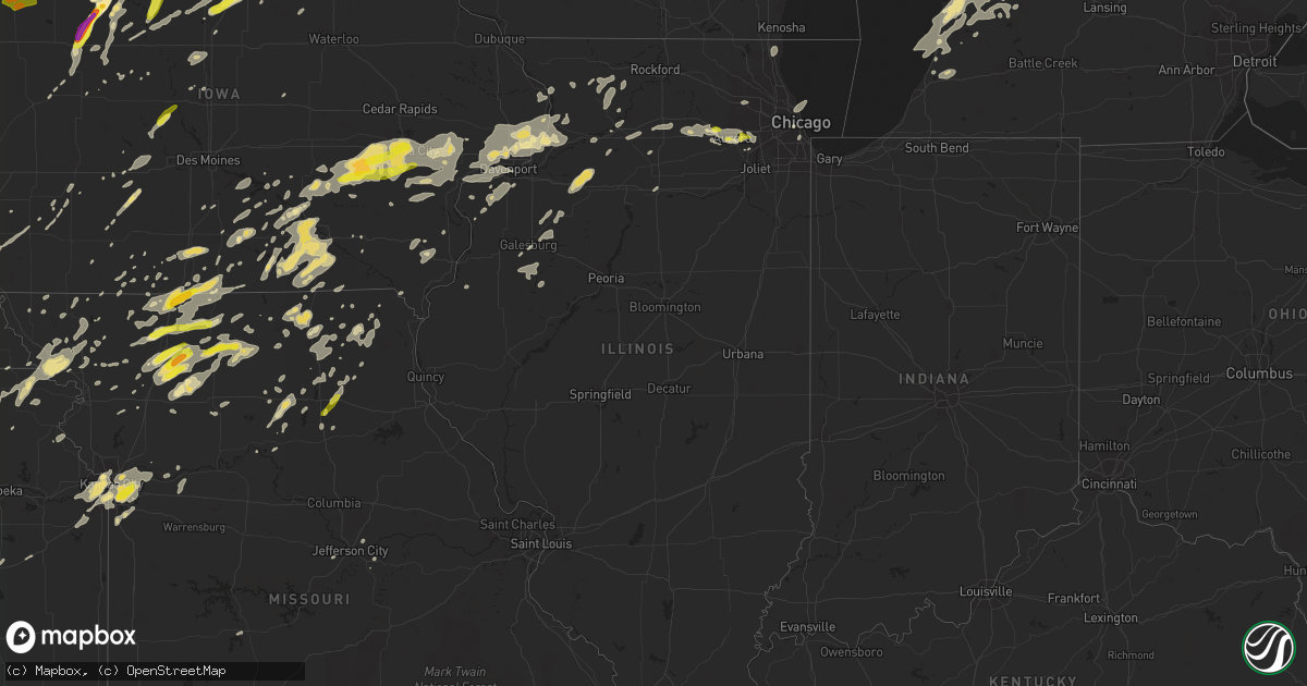
Hail Map in Illinois on August 28, 2018
Get this storm
August 28 map
$229
one time, instant access
Download today. No call, no setup
Keep the $229
Bought the map and want the full workflow? Apply the entire $229 to a subscription within 7 days. None of it is wasted.
Every map, not just this one
This buys you this map. Subscription and you get every map we run, in the markets you choose from a few cities to whole states to nationwide. Plus real-time alerts the moment a storm fires.
Contact data
Name, contact info, occupancy, even credit band for addresses in the footprint. You go from where it hit to who to call.
Become the source they trust
Unlimited branding weather history reports on demand. You already have the documented answer ready for the property owner, and you are the one who showed up with it.
Property data and RoofTrace estimates
Pull up any address you have got, its value and the exact code rules for that jurisdiction, straight from One Click Code. Then RoofTrace estimates the squares, pitch, and roof value, priced the way you price.
Storm reports in Illinois
Illinois
| Date | Description |
|---|---|
| 08/28/20185:15 PM CDT | 8 to 12 inch diameter tree limbs down along 600 block of sheffield and also 600 block of cambridge way. Time approximated from radar. |
| 08/28/20185:14 PM CDT | 4-6 inch tree limbs blown down on east royce road in bolingbrook. Via fb. Time estimated from radar. |
| 08/28/20185:00 AM CDT | At 1000 PM CDT, a severe thunderstorm was located over St. David, or near Canton, moving east at 55 mph. HAZARD...60 mph wind gusts and penny size hail. SOURCE...Radar indicated. IMPACT...Expect damage to roofs, siding, and trees. Locations impacted include... Peoria, Pekin, Canton, East Peoria, Morton, Washington, Bartonville, Creve Coeur, West Peoria, Marquette Heights, Farmington, Tremont, Bellevue, Mackinaw, Delavan, Manito, Hanna City, South Pekin, Glasford and Trivoli.This includes the following highways... Interstate 155 between mile markers 14 and 31. Interstate 474 between mile markers 3 and 14. Interstate 74 between mile markers 93 and 108. |
| 08/28/20184:29 AM CDT | At 928 PM CDT, severe thunderstorms were located along a line extending from near Marengo to Sycamore, moving southeast at 50 mph. HAZARD...60 mph wind gusts. SOURCE...Radar indicated. IMPACT...Expect damage to roofs, siding, and trees. Locations impacted include... Chicago, Aurora, Naperville, Elgin, Cicero, Arlington Heights, Evanston, Schaumburg, Palatine, Skokie, Des Plaines, Oak Lawn, Berwyn, Mount Prospect, Wheaton, Hoffman Estates, Oak Park, Downers Grove, Glenview and Elmhurst.The Mets at Cubs should seek safe shelter!Including the following interstates... I-55 between mile markers 275 and 294. I-57 between mile markers 355 and 358. I-88 between mile markers 124 and 140. I-90 between mile markers 22 and 25. I-94 between mile markers 26 and 68. I-290 between mile markers 1 and 29. I-294 between mile markers 26 and 68. I-355 between mile markers 17 and 30.This includes... Brookfield Zoo, Lincoln Park Zoo, LoyolaUniversity, Oakton Community College, Schaumburg Boomers Baseball,Toyota Park, Triton College, University of Chicago, College ofDuPage, DuPage County Fairgrounds, Elgin Community College, Fermilab,Harper College, Hawthorne Park, Kane County Cougars Ballpark, MortonArboretum, Northeastern Illinois University, Northwestern University,Soldier Field, University of Illinois Chicago, US Cellular Field...ILInstitute of Technology, Wheaton College, Wrigley Field, The Loop,Museum of Science and Industry, Museum Campus, and Northerly Island. |
| 08/28/20184:26 AM CDT | At 925 PM CDT, a severe thunderstorm was located over Golden, or 14 miles northeast of Quincy Regional Airport, moving east at 50 mph. HAZARD...60 mph wind gusts and penny size hail. SOURCE...Radar indicated. IMPACT...Expect damage to roofs, siding, and trees. Locations impacted include... Beardstown, Rushville, Astoria, Bluff Springs, Vermont, Littleton, Browning, Frederick, Huntsville, Camden, Ripley, Bluff City, Ray, Snicarte, Marbletown and Weinberg King State Park. |
| 08/28/20184:20 AM CDT | At 919 PM CDT, severe thunderstorms were located along a line extending from 6 miles east of Little York to Roseville to near Tennessee, moving east at 50 mph. HAZARD...60 mph wind gusts and penny size hail. SOURCE...Radar indicated. IMPACT...Expect damage to roofs, siding, and trees. Locations impacted include... Galesburg, Canton, Lewistown, Abingdon, Knoxville, Farmington, Elmwood, Cuba, Toulon, Brimfield, Wataga, Avon, Oneida, Yates City, Vermont, St. David, Williamsfield, Altona, Fairview and Ipava.This includes Interstate 74 between mile markers 34 and 75. |
| 08/28/20184:18 AM CDT | At 918 PM CDT, a severe thunderstorm was located over Sugar Grove, or near Aurora, moving east at 45 mph. HAZARD...60 mph wind gusts and quarter size hail. SOURCE...Radar indicated. IMPACT...Hail damage to vehicles is expected. Expect wind damage to roofs, siding, and trees. Locations impacted include... Aurora, Naperville, Bolingbrook, Wheaton, Romeoville, Plainfield, Oswego, West Chicago, Batavia, Lisle, Yorkville, Montgomery, North Aurora, Warrenville, Winfield, Sugar Grove and Boulder Hill.Including the following interstates... I-55 between mile markers 263 and 264. I-88 between mile markers 106 and 128.This includes... Aurora University, DuPage County Fairgrounds,Fermilab, IL Math and Science Academy, Waubonsee Community College,and North Central College. |
| 08/28/20184:10 AM CDT | At 910 PM CDT, severe thunderstorms were located along a line extending from near Grandview to near Oquawka, moving east at 55 mph. HAZARD...60 mph wind gusts. SOURCE...Radar indicated. IMPACT...Expect damage to roofs, siding, and trees. Locations impacted include... Aledo, Cambridge, Galva, Burgess, Viola, Woodhull, Millersburg, Matherville, New Boston, Alpha, Sherrard, Keithsburg, Andover, Eliza, Joy, Seaton, North Henderson, Hamlet, Cable and Shale City.This includes Interstate 74 in Illinois between mile markers 21 and33. |
| 08/28/20183:26 AM CDT | At 825 PM CDT, a severe thunderstorm was located near Salem, or near Mount Pleasant, moving east at 55 mph. HAZARD...60 mph wind gusts. SOURCE...Radar indicated. IMPACT...Expect damage to roofs, siding, and trees. Locations impacted include... Burlington, Mount Pleasant, Oquawka, West Burlington, New London, Mediapolis, Danville, Morning Sun, Salem, Middletown, Hillsboro, Oakville, Rome, Westwood, Mount Union, Gulf Port, Iowa Army Ammunition Plant, Lowell, Kossuth and Henry County Fairgrounds. |
| 08/28/20182:45 AM CDT | At 745 PM CDT, severe thunderstorms were located along a line extending from 6 miles north of Fulton to near Tampico to near Annawan, moving east at 60 mph. HAZARD...70 mph wind gusts and penny size hail. SOURCE...Radar indicated. IMPACT...Expect considerable tree damage. Damage is likely to mobile homes, roofs, and outbuildings. Locations impacted include... Ottawa, Dixon, Rochelle, Mendota, Oregon, Mount Morris, Walton, La Salle, Byron, Amboy, Polo, Earlville, Forreston, North Utica, Hillcrest, Stillman Valley, Franklin Grove, Ashton, Paw Paw and Naplate.Including the following interstates... I-39 between mile markers 58 and 101. I-80 between mile markers 73 and 90. I-88 between mile markers 45 and 79.This includes... Castle Rock State Park, Lee County Fairgrounds,Lowden State Park, Ogle County Fairgrounds, Sauk Valley College,Tri-County Fairgrounds, and White Pines State Park. |
| 08/28/20182:00 AM CDT | At 659 PM CDT, a severe thunderstorm was located near Toronto, or 12 miles east of Stanwood, moving east at 60 mph. HAZARD...70 mph wind gusts. SOURCE...Radar indicated. IMPACT...Expect considerable tree damage. Damage is likely to mobile homes, roofs, and outbuildings. Locations impacted include... Clinton, Maquoketa, Morrison, Mount Carroll, DeWitt, Camanche, Savanna, Bellevue, Stockton, Garden Plain, Preston, Fairhaven, Albany, Hanover, Wheatland, Elizabeth, Grand Mound, Woodbine, Sabula and Chadwick. |
| 08/28/20181:45 AM CDT | At 645 PM CDT, a severe thunderstorm was located over Mannon, or 12 miles east of Wapello, moving east at 55 mph. HAZARD...60 mph wind gusts and penny size hail. SOURCE...Radar indicated. IMPACT...Expect damage to roofs, siding, and trees. Locations impacted include... Kewanee, Aledo, Cambridge, Galva, Burgess, Orion, Viola, Woodhull, Millersburg, Matherville, New Boston, Alpha, Sherrard, Keithsburg, Andover, Reynolds, Eliza, Joy, Seaton and North Henderson.This includes Interstate 74 in Illinois between mile markers 20 and33. |
| 08/28/20181:18 AM CDT | At 617 PM CDT, a severe thunderstorm was located over Cotter, or near Columbus Junction, moving east at 60 mph. HAZARD...60 mph wind gusts and penny size hail. SOURCE...Radar indicated. IMPACT...Expect damage to roofs, siding, and trees. Locations impacted include... Washington, Wapello, Columbus Junction, Winfield, Fruitland, Wayland, Morning Sun, New Boston, Keithsburg, Ainsworth, Grandview, Eliza, Columbus City, Letts, Crawfordsville, Olds, Oakville, Cotter, Toolesboro and Wyman. |
| 08/28/201812:59 AM CDT | At 559 PM CDT, severe thunderstorms were located along a line extending from Williamsburg to near Harper, moving east at 60 mph. HAZARD...70 mph wind gusts. SOURCE...Radar indicated. IMPACT...Expect considerable tree damage. Damage is likely to mobile homes, roofs, and outbuildings. Locations impacted include... Iowa City, Muscatine, Tipton, West Branch, Durant, Coralville, North Liberty, West Liberty, Wilton, Tiffin, Lone Tree, University Heights, Riverside, Fruitland, Hills, Conesville, Bennett, Letts, Nichols and Atalissa.This includes the following highways... Interstate 80 in Iowa between mile markers 237 and 278. Interstate 380 between mile markers 1 and 2. |
| 08/27/201810:16 PM CDT | 12 inch diameter tree limb blocking george street in west chicago. |
| 08/27/201810:07 PM CDT | Delayed report. A small area of scattered wind damage on the north side of oak forest relayed by oak forest ema director...including some healthy trees and large tree l |
| 08/27/20189:45 PM CDT | Approximate 12 inch diameter tree uprooted at 75th street and lemont ave. Sporadic small tree limbs down between 75th and 87th streets. Time estimated from radar. |
| 08/27/20189:40 PM CDT | Numerous power lines down across western and southern dupage county... Some with tree branches on them. |
| 08/27/20189:37 PM CDT | A local report indicates 59 MPH wind near DUPAGE AIRPORT |
| 08/27/20189:30 PM CDT | Tree and power line down. |
| 08/27/20189:27 PM CDT | Tree down in aledo... Reported by electric company to sheriff's office. |
| 08/27/20189:18 PM CDT | Hail fell from 918 until 923 pm. |
| 08/27/20189:00 PM CDT | A local report indicates 60 MPH wind near CARTHAGE |
| 08/27/20188:45 PM CDT | Trees down on baxter road between 11th st and rydburg. |
| 08/27/20187:58 PM CDT | Snapped tree branches and downed apple trees due to saturated ground... Time estimated from radar. |
| 08/27/20187:50 PM CDT | 5 power poles were down at this location. 4 of them were leaning and one appeared to be snapped near the base. Corn in a field next to this location was damaged as well |
| 08/27/20187:50 PM CDT | Numerous tree limbs and small trees down in mount carroll... One tree on a house. Time estimated based on radar. |
| 08/27/20187:27 PM CDT | Em reported that widespread reports of tree damage were received across the county. Most of the damage was downed tree branches along with a couple of trees down on roa |
All States Impacted by Hail Map on August 28, 2018
Cities Impacted by Hail Map on August 28, 2018
- Harbor Beach, MI
- Ruth, MI
- Zion, IL
- Wadsworth, IL
- Waukegan, IL
- Gurnee, IL
- Kirkville, IA
- Floris, IA
- Moravia, IA
- Blakesburg, IA
- Chillicothe, IA
- Eddyville, IA
- Ottumwa, IA
- Drakesville, IA
- Moulton, IA
- Centerville, IA
- Albia, IA
- Bloomfield, IA
- Udell, IA
- Unionville, IA
- Mystic, IA
- Lyndon Station, WI
- Wisconsin Dells, WI
- Greenfield, IA
- Algona, IA
- West Bend, IA
- Whittemore, IA
- Ottosen, IA
- Waverly, IA
- Plainfield, IA
- Salisbury, MO
- Aurora, IL
- Cottonwood Falls, KS
- Pocahontas, IA
- Oshkosh, WI
- Allegan, MI
- Taylor Ridge, IL
- Milan, IL
- Aledo, IL
- Reynolds, IL
- Chariton, IA
- Knoxville, IA
- Melcher Dallas, IA
- Emerson, IA
- Orrick, MO
- Algoma, WI
- Sturgeon Bay, WI
- Miami, TX
- Canadian, TX
- Kansas City, KS
- Bremen, KS
- Offutt Afb, NE
- Booker, TX
- Follett, TX
- Balko, OK
- Darrouzett, TX
- Laverne, OK
- Maryville, MO
- West Union, IA
- La Crosse, WI
- La Crescent, MN
- Colwell, IA
- Charles City, IA
- Mount Carroll, IL
- Lanark, IL
- Weldon, IA
- Osceola, IA
- Humeston, IA
- Grand River, IA
- Van Wert, IA
- Iowa City, IA
- Coralville, IA
- Tiffin, IA
- Oxford, IA
- Parnell, IA
- North English, IA
- South English, IA
- Glenwood, IA
- Mount Pleasant, IA
- Brookfield, MO
- Marceline, MO
- Garner, IA
- Britt, IA
- Klemme, IA
- Black Creek, WI
- Eagle Grove, IA
- Badger, IA
- Vincent, IA
- Thor, IA
- Fort Dodge, IA
- Sterling, NE
- Fonda, IA
- Rolfe, IA
- Havelock, IA
- Palmer, IA
- Manson, IA
- Maple City, MI
- La Salle, IL
- Peru, IL
- Coal Valley, IL
- Medford, OK
- Dawn, MO
- Pelham, GA
- Newton, GA
- Camilla, GA
- Bethany, MO
- New Hampton, MO
- Hawkeye, IA
- Waucoma, IA
- Kansas City, MO
- Dakota City, IA
- Thornton, IA
- Lu Verne, IA
- Ridgeway, IA
- Forest City, IA
- Ventura, IA
- Bode, IA
- Woden, IA
- Marble Rock, IA
- Fredericksburg, IA
- Crystal Lake, IA
- Lawler, IA
- Renwick, IA
- Clear Lake, IA
- Rockford, IA
- Saint Lucas, IA
- New Hampton, IA
- Kanawha, IA
- Hardy, IA
- Corwith, IA
- Calmar, IA
- Nora Springs, IA
- Mason City, IA
- Swaledale, IA
- Ionia, IA
- Rudd, IA
- Meservey, IA
- Wesley, IA
- Sumner, IA
- Castalia, IA
- Ossian, IA
- Mallard, IA
- Livermore, IA
- Fort Atkinson, IA
- Goodell, IA
- Humboldt, IA
- Rockwell, IA
- Nashua, IA
- Galt, MO
- Trenton, MO
- Humphreys, MO
- Spickard, MO
- Kalona, IA
- Glidden, IA
- Nash, OK
- Wakita, OK
- Green Bay, WI
- Mount Ayr, IA
- Cordova, IL
- Camanche, IA
- De Witt, IA
- Low Moor, IA
- Walcott, IA
- Davenport, IA
- Dixon, IA
- Fenton, IL
- Clinton, IA
- Eldridge, IA
- Fulton, IL
- Le Claire, IA
- Stockton, IA
- Erie, IL
- Albany, IL
- Princeton, IA
- McCausland, IA
- Long Grove, IA
- Lamoni, IA
- Blythedale, MO
- Davis City, IA
- Cainsville, MO
- Eagleville, MO
- Cosby, MO
- Savannah, MO
- Polo, IL
- Oregon, IL
- Ravenwood, MO
- Plano, IA
- Manchester, OK
- Port Saint Joe, FL
- Lees Summit, MO
- Lineville, IA
- Leon, IA
- Allerton, IA
- West Branch, IA
- West Liberty, IA
- Waukon, IA
- Jolley, IA
- Sac City, IA
- Lytton, IA
- Melrose, IA
- Unionville, MO
- Greentop, MO
- Novinger, MO
- Glenwood, MO
- Kirksville, MO
- Worthington, MO
- Green Castle, MO
- Livonia, MO
- Queen City, MO
- Mission, KS
- Bonner Springs, KS
- Riverside, MO
- Lenexa, KS
- Shawnee, KS
- De Soto, KS
- Lovilia, IA
- Bussey, IA
- Robinson, KS
- Troy, KS
- Everest, KS
- Denton, KS
- Kendall, WI
- El Dorado, KS
- Burns, KS
- Leland, MI
- Lake Leelanau, MI
- Northport, MI
- Columbus, WI
- Hermitage, MO
- Saugatuck, MI
- Sugar Grove, IL
- Poy Sippi, WI
- Redgranite, WI
- Pine River, WI
- Lake View, IA
- Hamilton, MO
- Chillicothe, MO
- Lock Springs, MO
- Gallatin, MO
- Breckenridge, MO
- Jamesport, MO
- Leedey, OK
- Hammon, OK
- Danville, IA
- New London, IA
- Nebraska City, NE
- Dunbar, NE
- Otoe, NE
- Independence, MO
- Luray, MO
- Frankfort, KS
- Willis, TX
- Carroll, IA
- Sallis, MS
- Ridgeway, MO
- Bear Lake, MI
- Thompsonville, MI
- Copemish, MI
- Princeton, WI
- Montello, WI
- Plano, IL
- Big Rock, IL
- Tingley, IA
- Diagonal, IA
- Appleton, WI
- Rockwell City, IA
- Ogden, IA
- Woodward, IA
- Dawson, IA
- Perry, IA
- Bennett, IA
- Jackson, LA
- Ainsworth, IA
- Hanover, KS
- Barnes, KS
- Marysville, KS
- Palmyra, NE
- Avoca, NE
- Unadilla, NE
- Weeping Water, NE
- Syracuse, NE
- Shattuck, OK
- New Cambria, MO
- Pattonsburg, MO
- Coffey, MO
- Spring Hill, FL
- Wetmore, KS
- Powhattan, KS
- Fairview, KS
- Russell, IA
- New Waverly, TX
- Holland, MI
- Hamilton, MI
- Douglas, MI
- Fennville, MI
- Zeeland, MI
- Morrison, IL
- Orchard, IA
- Caledonia, MI
- Alto, MI
- Gorin, MO
- Hartford, MI
- Watervliet, MI
- Lawrence, MI
- Bangor, MI
- Avon, IL
- Gilson, IL
- London Mills, IL
- Saint Augustine, IL
- Abingdon, IL
- Berwick, IL
- Maquon, IL
- South Haven, MI
- Perryton, TX
- Jameson, MO
- Gilman City, MO
- Harpers Ferry, IA
- Baileyville, IL
- German Valley, IL
- Forreston, IL
- Shannon, IL
- Freeport, IL
- Ionia, MI
- Adams, NE
- Firth, NE
- Colquitt, GA
- Laurens, IA
- Whiting, KS
- Westboro, MO
- McIntosh, AL
- Leawood, KS
- Overland Park, KS
- Prairie Village, KS
- Princeton, MO
- Chicago, IL
- Clarence, MO
- Anabel, MO
- Macon, MO
- Liberty, MO
- Buckner, MO
- Olathe, KS
- Sibley, MO
- Blue Springs, MO
- West Salem, WI
- Crestview, FL
- Williamsburg, IA
- Webster, IA
- Keswick, IA
- South Amana, IA
- Postville, IA
- Leaf River, IL
- Rose Hill, IA
- Delta, IA
- What Cheer, IA
- Forest City, MO
- Maitland, MO
- White Cloud, KS
- Oregon, MO
- Fillmore, MO
- Mound City, MO
- Craig, MO
- Lowell, MI
- Ada, MI
- Greene, IA
- Griswold, IA
- Treynor, IA
- Prescott, IA
- Tallahassee, FL
- Oskaloosa, IA
- Bristol, IL
- Yorkville, IL
- Blair, NE
- Bennington, NE
- Omaha, NE
- Ellisville, IL
- Maysville, MO
- Mount Calvary, WI
- Malta, IL
- Lee, IL
- Ashton, IL
- Steward, IL
- Bucklin, MO
- Bangor, WI
- Coon Valley, WI
- Goff, KS
- Sabetha, KS
- Columbia, IA
- Lacona, IA
- New London, WI
- Hortonville, WI
- Casco, WI
- Luxemburg, WI
- Forestville, WI
- Saranac, MI
- Belding, MI
- King City, MO
- Oxford, WI
- Westfield, WI
- Grand Marsh, WI
- Arbela, MO
- Panhandle, TX
- White Deer, TX
- Gilmore City, IA
- Pickrell, NE
- Panama City, FL
- Wyoming, MI
- Stanhope, IA
- Jewell, IA
- Kamrar, IA
- Indianola, IA
- New Virginia, IA
- Kellerton, IA
- Lansing, IA
- Skidmore, MO
- Graham, MO
- Benton, KS
- Valley Center, KS
- Towanda, KS
- New Bloomfield, MO
- Tebbetts, MO
- Holts Summit, MO
- Montgomery, IL
- Franklin, TX
- Albany, MO
- McFall, MO
- Downing, MO
- Briscoe, TX
- Wheeler, TX
- Decorah, IA
- Elburn, IL
- New Sharon, IA
- Wymore, NE
- Odell, NE
- Falls City, NE
- Hiawatha, KS
- Greenleaf, KS
- Latimer, IA
- Hampton, IA
- Alexander, IA
- Marshalltown, IA
- Amboy, IL
- Dixon, IL
- Franklin Grove, IL
- Plattsmouth, NE
- Bellevue, NE
- Barnard, MO
- O'Brien, FL
- Mendota, IL
- West Brooklyn, IL
- Pella, IA
- Perry, FL
- Oketo, KS
- Chilton, WI
- Elroy, WI
- Mauston, WI
- Belmond, IA
- Clarion, IA
- Ames, IA
- Gilbert, IA
- Tecumseh, NE
- Steinauer, NE
- Skellytown, TX
- Neshkoro, WI
- Oneida, IL
- Victoria, IL
- Knoxville, IL
- Altona, IL
- Galesburg, IL
- Waterman, IL
- Hinckley, IL
- Green Lake, WI
- Mabel, MN
- Spring Grove, MN
- Atlantic, IA
- Green City, MO
- Mercer, MO
- Harmon, IL
- Horton, KS
- Netawaka, KS
- Highland, KS
- Bolckow, MO
- Grant City, MO
- Martinsville, MO
- Hatfield, MO
- La Farge, WI
- Slater, MO
- Miami, MO
- Cedar Point, KS
- Arlington, GA
- La Plata, MO
- Tarkio, MO
- Leonard, MO
- Tipton, IA
- Atalissa, IA
- Vail, IA
- Orient, IA
- Dexter, IA
- Lenox, IA
- New Franken, WI
- Murray, NE
- Osborn, MO
- Sigourney, IA
- Erick, OK
- Normangee, TX
- Altha, FL
- Lena, MS
- Carthage, MS
- Conesville, IA
- Columbus Junction, IA
- Nichols, IA
- Lone Tree, IA
- Lewis, IA
- Saint Marys, KS
- Cheyenne, OK
- Winneconne, WI
- Elkton, MI
- Pacific Junction, IA
- Malvern, IA
- Thurman, IA
- Tabor, IA
- Hastings, IA
- Wellman, IA
- Keota, IA
- Marengo, IA
- North Liberty, IA
- Moscow, IA
- Deep River, IA
- Barnes City, IA
- Riverside, IA
- Hills, IA
- Harper, IA
- Wilton, IA
- Washington, IA
- Homestead, IA
- Solon, IA
- Letts, IA
- Muscatine, IA
- Millersburg, IA
- Tomball, TX
- Wonewoc, WI
- Arnett, OK
- Shabbona, IL
- North Aurora, IL
- Mooseheart, IL
- Naperville, IL
- Dekalb, IL
- Oswego, IL
- Maple Park, IL
- Batavia, IL
- Guilford, MO
- Buckley, MI
- Kingsley, MI
- Tawas City, MI
- Missouri Valley, IA
- Harris, MO
- Pollock, MO
- Milan, MO
- Newtown, MO
- Orleans, MI
- Paxico, KS
- Edina, MO
- Rutledge, MO
- Batavia, IA
- Fairfield, IA
- Waverly, NE
- Lincoln, NE
- Sheffield, IL
- Mineral, IL
- Walnut, IL
- Annawan, IL
- Tampico, IL
- Clarksville, IA
- Shell Rock, IA
- Fremont, WI
- Lohrville, IA
- Lohman, MO
- Russellville, MO
- Bradgate, IA
- Green, KS
- Baker, FL
- Decatur, IA
- Alta Vista, KS
- Cambria, WI
- Markesan, WI
- Randolph, WI
- Friesland, WI
- Memphis, MO
- Mobeetie, TX
- Stuart, IA
- Menlo, IA
- Wamego, KS
- Alma, KS
- Brandon, WI
- Waupun, WI
- Goltry, OK
- Morrill, KS
- Baileyville, KS
- Seneca, KS
- Sparta, WI
- Boone, IA
- Henrietta, MO
- Joy, IL
- Galva, IL
- Atlanta, MO
- Novelty, MO
- Wautoma, WI
- Pampa, TX
- Cuthbert, GA
- Coleman, GA
- Clearwater, FL
- Saint Petersburg, FL
- Pinellas Park, FL
- Churdan, IA
- Farnhamville, IA
- Otley, IA
- Corydon, IA
- Crawford, OK
- Augusta, KS
- Andover, KS
- Cashton, WI
- Atchison, KS
- Wyaconda, MO
- Grand Rapids, MI
- Clare, IA
- Newark, MO
- Fond Du Lac, WI
- Lake City, IA
- Gravity, IA
- Casey, IA
- Thomson, IL
- Cameron, MO
- Gloster, MS
- Rowan, IA
- Dows, IA
- Elmdale, KS
- Williams, IA
- Leighton, IA
- Alta Vista, IA
- Elma, IA
- Fenwick, MI
- Donahue, IA
- Montpelier, IA
- Illinois City, IL
- Calamus, IA
- Port Byron, IL
- Hillsdale, IL
- New Liberty, IA
- Goose Lake, IA
- Moline, IL
- Blue Grass, IA
- Durant, IA
- Buffalo, IA
- Rock Island, IL
- Grand Mound, IA
- Joice, IA
- Hanlontown, IA
- Manly, IA
- Fertile, IA
- Kensett, IA
- Mears, MI
- Custer, MI
- Pentwater, MI
- Hart, MI
- Shelby, MI
- Branch, MI
- Oneida, WI
- De Pere, WI
- Belton, MO
- Raymore, MO
- Grandview, MO
- Gowrie, IA
- Harcourt, IA
- Groom, TX
- Cambridge, IL
- Woodhull, IL
- Douds, IA
- Paton, IA
- Waterville, KS
- Keytesville, MO
- Wilton, WI
- Lucas, IA
- Elliott, IA
- Woodville, MS
- Neenah, WI
- Greenville, WI
- Farmington, IA
- Argyle, IA
- Adair, IA
- Rosendale, MO
- Laredo, MO
- Rockland, WI
- Creston, IA
- Cairo, MO
- Talmage, NE
- Leary, GA
- Wewahitchka, FL
- Sheffield, IA
- Galt, IA
- Plainfield, IL
- Conception, MO
- Stanberry, MO
- De Soto, WI
- Coatsville, MO
- Vermillion, KS
- Axtell, KS
- Baraboo, WI
- Altamont, MO
- Browning, MO
- Winston, MO
- Weatherby, MO
- Westphalia, MO
- Montgomery, TX
- Magnolia, TX
- Orlando, FL
- Kissimmee, FL
- Breda, IA
- Westside, IA
- Gary, TX
- Florien, LA
- Gentry, MO
- Worth, MO
- Denver, MO
- Cypress, TX
- Comstock Park, MI
- Bolingbrook, IL
- Woodridge, IL
- Lisle, IL
- Barneston, NE
- Potwin, KS
- Whitewater, KS
- Greenville, FL
- Keithsburg, IL
- Knox City, MO
- Bennet, NE
- Strong City, KS
- Free Soil, MI
- Ludington, MI
- Manistee, MI
- Jacksonville, MO
- West Point, IA
- Callao, MO
- Sayre, OK
- Leesville, LA
- Seymour, WI
- Kaukauna, WI
- Norwalk, WI
- Stewartsville, MO
- Gower, MO
- Plattsburg, MO
- Louisville, NE
- Reydon, OK
- Excello, MO
- Savanna, IL
- Ocala, FL
- Rock Falls, IL
- Council Grove, KS
- Hurdland, MO
- Lake Mills, IA
- Leland, IA
- Thompson, IA
- Lebo, KS
- Melvern, KS
- Scottville, MI
- Gibbs, MO
- Redding, IA
- Blockton, IA
- Rea, MO
- Mendon, MO
- Beaver, OK
- Conroe, TX
- Spring, TX
- Jenison, MI
- Odessa, MO
- Mayview, MO
- Lexington, MO
- Burr, NE
- Douglas, NE
- Pulaski, IA
- Seymour, IA
- Sheridan, MO
- Suttons Bay, MI
- Hancock, WI
- Friendship, WI
- Arkdale, WI
- Nekoosa, WI
- Burlington Junction, MO
- Cameron, IL
- Wiota, IA
- Durham, OK
- Benton, IA
- Bedford, IA
- Centralia, KS
- Greenwich, KS
- Wichita, KS
- Dougherty, IA
- Linden, IA
- Redfield, IA
- Crab Orchard, NE
- Owendale, MI
- Bad Axe, MI
- Beaver Dam, WI
- Viroqua, WI
- Gays Mills, WI
- Soldiers Grove, WI
- Ferryville, WI
- Camden, MO
- Montezuma, IA
- Gibson, IA
- Swan, IA
- Pleasantville, IA
- La Belle, MO
- Baring, MO
- Humboldt, NE
- Stella, NE
- New Bedford, IL
- Kewanee, IL
- Fox Lake, WI
- Wall Lake, IA
- Auburn, IA
- Goldfield, IA
- Floyd, IA
- Spillville, IA
- Clermont, IA
- Wayland, MI
- Barnum, IA
- Clearmont, MO
- Hopkins, MO
- Lucerne, MO
- Clarksdale, MO
- Amity, MO
- Blue Rapids, KS
- Garden Grove, IA
- Rulo, NE
- Cook, NE
- Readstown, WI
- Viola, WI
- Mount Morris, IL
- Linn, MO
- Loose Creek, MO
- Bonnots Mill, MO
- Portage, WI
- Chapin, IA
- Westmoreland, KS
- Clio, IA
- Darlington, MO
- Texola, OK
- Guthrie Center, IA
- Endeavor, WI
- Packwaukee, WI
- Reedsburg, WI
- La Valle, WI
- New Boston, IL
- Auburn, NE
- Middleville, MI
- Murdock, NE
- Elmwood, NE
- Florence, KS
- Tripoli, IA
- Sabula, IA
- Miles, IA
- Oneida, KS
- Bern, KS
- Brashear, MO
- Bartlett, IL
- Streamwood, IL
- Schaumburg, IL
- Elgin, IL
- Fort Calhoun, NE
- Ellston, IA
- New Boston, MO
- Leroy, AL
- Edgerton, KS
- Spring Hill, KS
- Gardner, KS
- Hillsboro, WI
- Corning, KS
- Mediapolis, IA
- Morning Sun, IA
- Conway Springs, KS
- Wellington, KS
- New Lisbon, WI
- Union Star, MO
- Jackson, AL
- Dorr, MI
- Pullman, MI
- Byron Center, MI
- Grand Junction, MI
- Hudsonville, MI
- Hopkins, MI
- Grandville, MI
- Covert, MI
- Coloma, MI
- Shepherd, TX
- Coldspring, TX
- Eglin Afb, FL
- La Harpe, IL
- Dallas City, IL
- Many, LA
- Red Oak, IA
- Beattie, KS
- Roxie, MS
- Hamilton, IA
- Bristow, IA
- Aredale, IA
- Butte Des Morts, WI
- Omro, WI
- Lakeview, MI
- Blanchard, MI
- Pomona, KS
- Williamsburg, KS
- Ottawa, KS
- Lancaster, MO
- Dickens, IA
- Peterson, IA
- Sioux Rapids, IA
- Webb, IA
- Paullina, IA
- Sutherland, IA
- Cylinder, IA
- Ruthven, IA
- Curlew, IA
- Hartley, IA
- Marathon, IA
- Gillett Grove, IA
- Ayrshire, IA
- Greenville, IA
- Royal, IA
- Linn Grove, IA
- Emmetsburg, IA
- Calumet, IA
- Primghar, IA
- Spencer, IA
- Cleghorn, IA
- Cherokee, IA
- Aurelia, IA
- Alta, IA
- Meriden, IA


