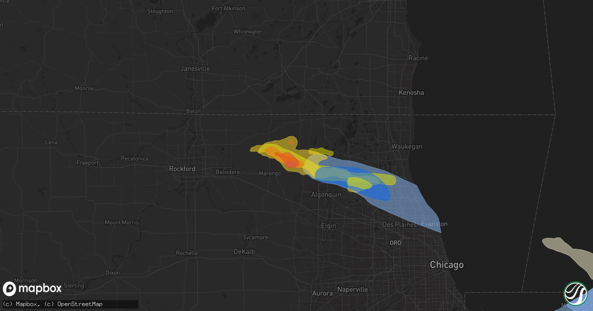
Hail Map in Woodstock, IL on August 27, 2024
Get this storm
August 27 map
$229
one time, instant access
Download today. No call, no setup
Keep the $229
Bought the map and want the full workflow? Apply the entire $229 to a subscription within 7 days. None of it is wasted.
Every map, not just this one
This buys you this map. Subscription and you get every map we run, in the markets you choose from a few cities to whole states to nationwide. Plus real-time alerts the moment a storm fires.
Contact data
Name, contact info, occupancy, even credit band for addresses in the footprint. You go from where it hit to who to call.
Become the source they trust
Unlimited branding weather history reports on demand. You already have the documented answer ready for the property owner, and you are the one who showed up with it.
Property data and RoofTrace estimates
Pull up any address you have got, its value and the exact code rules for that jurisdiction, straight from One Click Code. Then RoofTrace estimates the squares, pitch, and roof value, priced the way you price.
Storm reports in Woodstock, IL
Woodstock, IL
| Date | Description |
|---|---|
| 08/27/20245:29 PM CDT | Near rt 14 and dean street... Relayed by county ema. |
| 08/27/20245:29 PM CDT | A video received via social media shows hail up to 2.5 inches in diameter approximately 2 miles south of woodstock. |
| 08/27/20245:20 PM CDT | Near the intersection of rt 14 and rose farm road in woodstock. Relayed by county ema. |
All States Impacted by Hail Map on August 27, 2024
All Cities Impacted by Hail Map on August 27, 2024
- New Auburn, WI
- Cameron, WI
- Chetek, WI
- Bloomer, WI
- Weyerhaeuser, WI
- Eau Claire, WI
- Spooner, WI
- Sarona, WI
- Krakow, WI
- Birchwood, WI
- Stone Lake, WI
- Springbrook, WI
- Stanley, WI
- Thorp, WI
- Owen, WI
- Withee, WI
- Camp Douglas, WI
- Necedah, WI
- Neillsville, WI
- Arkdale, WI
- Nekoosa, WI
- Manitowoc, WI
- Friendship, WI
- Mauston, WI
- Cleveland, WI
- Newton, WI
- Hancock, WI
- Grand Marsh, WI
- Adams, WI
- Endeavor, WI
- Oxford, WI
- Plover, WI
- Westfield, WI
- Bancroft, WI
- Plainfield, WI
- Coloma, WI
- Iola, WI
- Wild Rose, WI
- Montello, WI
- Almond, WI
- Stevens Point, WI
- Amherst, WI
- Waupaca, WI
- Dalton, WI
- Ogdensburg, WI
- Scandinavia, WI
- Pine River, WI
- Berlin, WI
- Redgranite, WI
- Weyauwega, WI
- Winter, WI
- Manawa, WI
- New London, WI
- Wautoma, WI
- Fremont, WI
- Poy Sippi, WI
- Hortonville, WI
- Larsen, WI
- Deforest, WI
- Oshkosh, WI
- Omro, WI
- Shiocton, WI
- Greenville, WI
- Menasha, WI
- Hilbert, WI
- Sherwood, WI
- Sobieski, WI
- Pulaski, WI
- Appleton, WI
- Kaukauna, WI
- Neenah, WI
- Little Chute, WI
- Seymour, WI
- Black Creek, WI
- De Pere, WI
- Oneida, WI
- Waterloo, WI
- Marshall, WI
- Van Dyne, WI
- Fond Du Lac, WI
- Green Bay, WI
- Denmark, WI
- Wrightstown, WI
- Kimberly, WI
- Maribel, WI
- Greenleaf, WI
- Juneau, WI
- New Franken, WI
- Luxemburg, WI
- Kewaunee, WI
- Horicon, WI
- Iron Ridge, WI
- Watertown, WI
- Lowell, WI
- Mayville, WI
- Theresa, WI
- Algoma, WI
- Casco, WI
- Hartford, WI
- West Bend, WI
- Allenton, WI
- Kewaskum, WI
- Johnson Creek, WI
- Rubicon, WI
- Neosho, WI
- Random Lake, WI
- Fredonia, WI
- Adell, WI
- Ixonia, WI
- Oconomowoc, WI
- Fort Atkinson, WI
- Ashippun, WI
- Edgerton, WI
- Milton, WI
- Belgium, WI
- Delafield, WI
- Nashotah, WI
- Hartland, WI
- Pewaukee, WI
- Anderson, TX
- North Prairie, WI
- Mukwonago, WI
- Waukesha, WI
- Iola, TX
- Big Bend, WI
- Bitely, MI
- Montgomery, TX
- Magnolia, TX
- Kanopolis, KS
- Hersey, MI
- Big Rapids, MI
- Paris, MI
- Ellsworth, KS
- Mount Pleasant, MI
- Gladwin, MI
- Beaverton, MI
- Coleman, MI
- Shepherd, MI
- Muskegon, MI
- Alger, MI
- Wheeler, MI
- Merrill, MI
- Freeland, MI
- South Haven, MI
- Sheridan, MI
- Fenwick, MI
- Greenville, MI
- Lowell, MI
- Ada, MI
- Grand Rapids, MI
- Comstock Park, MI
- Saginaw, MI
- Midland, MI
- Hemlock, MI
- El Campo, TX
- Garwood, TX
- Saranac, MI
- Hubbardston, MI
- Hastings, MI
- Middleton, MI
- Carson City, MI
- Kawkawlin, MI
- Bay City, MI
- Linwood, MI
- Portland, MI
- Carrollton, MI
- Cassopolis, MI
- Whittemore, MI
- University Center, MI
- Lincoln, TX
- New Carlisle, IN
- National City, MI
- Omer, MI
- Twining, MI
- Marcellus, MI
- Woodland, MI
- Dewitt, MI
- Saint Johns, MI
- Nashville, MI
- Westphalia, MI
- Ionia, MI
- Lyons, MI
- Pewamo, MI
- Eagle, MI
- Fowler, MI
- Sunfield, MI
- Grand Ledge, MI
- Bancroft, MI
- Bath, MI
- Lansing, MI
- East Lansing, MI
- Morrice, MI
- Owosso, MI
- Perry, MI
- Laingsburg, MI
- Okemos, MI
- Williamston, MI
- Haslett, MI
- Auburn, MI
- Lennon, MI
- Swartz Creek, MI
- Flushing, MI
- Durand, MI
- Corunna, MI
- Vernon, MI
- Oakley, MI
- Tawas City, MI
- Turner, MI
- Bennington, KS
- Frankenmuth, MI
- Dowling, MI
- Mishawaka, IN
- South Bend, IN
- Granger, IN
- Pigeon, MI
- Elkton, MI
- Caseville, MI
- Kinde, MI
- Gaines, MI
- Webberville, MI
- Flint, MI
- Byron, MI
- Fowlerville, MI
- Bellevue, MI
- Three Rivers, MI
- Clio, MI
- Montrose, MI
- Mount Morris, MI
- Bad Axe, MI
- Leonidas, MI
- Colon, MI
- Bay Port, MI
- Abilene, KS
- Harrisonville, MO
- Vandalia, MI
- Athens, MI
- Birch Run, MI
- Mason, MI
- Burton, MI
- Linden, MI
- Grand Blanc, MI
- Fenton, MI
- Holly, MI
- Marshall, MI
- Rives Junction, MI
- Davison, MI
- Albion, MI
- Parma, MI
- Leslie, MI
- Harbor Beach, MI
- Pleasant Hill, MO
- Garden City, MO
- Constantine, MI
- Genesee, MI
- Otisville, MI
- West Point, TX
- Jones, MI
- Centreville, MI
- Burr Oak, MI
- Elkhart, IN
- White Lake, MI
- Davisburg, MI
- Highland, MI
- Clarkston, MI
- Ortonville, MI
- Waterford, MI
- Goodrich, MI
- Bronson, MI
- White Pigeon, MI
- Lapeer, MI
- Fostoria, MI
- North Branch, MI
- Lucas, KS
- Ruth, MI
- Sherwood, MI
- Homer, MI
- Middlebury, IN
- Bristol, IN
- Jackson, MI
- Minneapolis, KS
- Goshen, IN
- Mission, TX
- Edinburg, TX
- Pleasant Lake, MI
- La Grange, TX
- Sturgis, MI
- Coldwater, MI
- Pontiac, MI
- Luray, KS
- Litchfield, MI
- Dexter, MI
- Chelsea, MI
- Ann Arbor, MI
- Enterprise, KS
- Howe, IN
- Shelbina, MO
- Clay Center, KS
- East Lynne, MO
- Imlay City, MI
- Attica, MI
- Thorndale, TX
- Thrall, TX
- Beloit, WI
- Shipshewana, IN
- Quincy, MI
- Clarklake, MI
- Jerome, MI
- Horton, MI
- Hanover, MI
- Concordia, KS
- Dunnellon, FL
- Monroe City, MO
- Russell, KS
- Allen, MI
- Bloomfield Hills, MI
- Keego Harbor, MI
- Auburn Hills, MI
- Sterling Heights, MI
- Troy, MI
- West Bloomfield, MI
- Rochester, MI
- Royal Oak, MI
- Clawson, MI
- Madison Heights, MI
- Birmingham, MI
- Franklin, MI
- Commerce Township, MI
- Reading, MI
- Garden Prairie, IL
- Harvard, IL
- Macon, MO
- Anabel, MO
- Livonia, MO
- Longview, TX
- Chapman, KS
- Clarence, MO
- Lentner, MO
- Madison, MO
- Palmyra, MO
- Clinton, WI
- Manchester, MI
- Jonesville, MI
- South Beloit, IL
- Cement City, MI
- Orland, IN
- Marengo, IL
- Woodstock, IL
- Harper Woods, MI
- Grosse Pointe, MI
- Hazel Park, MI
- Center Line, MI
- Detroit, MI
- Warren, MI
- Eastpointe, MI
- Roseville, MI
- Saint Clair Shores, MI
- Bucyrus, KS
- Overland Park, KS
- Glenwood, MO
- Queen City, MO
- Junction City, KS
- Waldo, KS
- Chilton, TX
- Lott, TX
- Hannibal, MO
- Olathe, KS
- Paris, MO
- Santa Fe, MO
- Brooklyn, MI
- Linwood, KS
- Dwight, KS
- Belton, MO
- Fraser, MI
- Clinton Township, MI
- Harrison Township, MI
- Eddy, TX
- Holden, MO
- Stilwell, KS
- Coatsville, MO
- Kent City, MI
- Elmer, MO
- Ethel, MO
- Alta Vista, KS
- Freeman, MO
- De Soto, KS
- Casnovia, MI
- Crystal Lake, IL
- Greentop, MO
- Creighton, MO
- Rutledge, MO
- Gorin, MO
- Lancaster, MO
- Huntley, IL
- Mchenry, IL
- Hebron, IL
- Union, IL
- Tonganoxie, KS
- Rio Grande City, TX
- Morganville, KS
- Wauseon, OH
- Bonner Springs, KS
- White City, KS
- Peculiar, MO
- Cary, IL
- Barrington, IL
- Island Lake, IL
- Wauconda, IL
- Kansas City, MO
- Kirksville, MO
- Atlanta, MO
- La Plata, MO
- Blairstown, MO
- Lenexa, KS
- Arbela, MO
- Downing, MO
- Luray, MO
- Beloit, KS
- Center, MO
- Cleveland, MO
- Belleville, KS
- Perry, MO
- Lawrence, KS
- Holliday, MO
- Memphis, MO
- Excello, MO
- Mundelein, IL
- Lake Zurich, IL
- Jamestown, KS
- Manhattan, KS
- Bluff Dale, TX
- Tolar, TX
- Scandia, KS
- Kansas City, KS
- Jacksonville, MO
- Drexel, MO
- Louisburg, KS
- Del Rio, TX
- Jasper, MI
- Delta, OH
- Round Lake, IL
- Grayslake, IL
- Fox River Grove, IL
- Vernon Hills, IL
- Libertyville, IL
- Lincolnshire, IL
- Buffalo Grove, IL
- Lake Forest, IL
- Palatine, IL
- Arlington Heights, IL
- Wheeling, IL
- Deerfield, IL
- Edina, MO
- Baring, MO
- Liberty Center, OH
- Prairie Village, KS
- Hurdland, MO
- Gardner, KS
- Novelty, MO
- Swanton, OH
- Donnellson, IA
- Kahoka, MO
- Highwood, IL
- Highland Park, IL
- Northbrook, IL
- Glencoe, IL
- Wilmette, IL
- Glenview, IL
- Prospect Heights, IL
- Winnetka, IL
- Kenilworth, IL
- Mount Prospect, IL
- Skokie, IL
- Morton Grove, IL
- Golf, IL
- Chicago, IL
- Evanston, IL
- Riverside, MO
- Lyons, OH
- Knox City, MO
- Westmoreland, KS
- Frankfort, KS
- Spring Hill, KS
- Hallsville, MO
- Topeka, KS
- Sand Creek, MI
- Berkey, OH
- Archbold, OH
- Sylvania, OH
- Holland, OH
- Toledo, OH
- Blissfield, MI
- Metamora, OH
- Fayette, OH
- Grand Rapids, OH
- Waterville, OH
- Rossford, OH
- Neapolis, OH
- Maumee, OH
- Napoleon, OH
- Monclova, OH
- Perrysburg, OH
- Whitehouse, OH
- Dunbridge, OH
- Bowling Green, OH
- Custar, OH
- Pemberville, OH
- Luckey, OH
- Haskins, OH
- Weston, OH
- McClure, OH
- Tontogany, OH
- Portage, OH
- North Baltimore, OH
- Milton Center, OH
- Rudolph, OH
- Van Buren, OH
- Cygnet, OH
- Wayne, OH
- Bradner, OH
- Jerry City, OH
- West Millgrove, OH
- Fostoria, OH
- Bloomdale, OH
- Kansas, OH
- Helena, OH
- Risingsun, OH
- Gibsonburg, OH
- Findlay, OH
- Alvada, OH
- Arcadia, OH
- Tiffin, OH
- New Riegel, OH
- Bascom, OH
- Farmington, IA
- Callao, MO
- Somerset, TX
- Von Ormy, TX
- Perry, KS
- Rolling Meadows, IL
- Schaumburg, IL
- San Antonio, TX
- Oskaloosa, KS
- Valley Falls, KS
- Eudora, KS
- Brashear, MO
- Novinger, MO
- Oneida, IL
- Platte City, MO
- Smithville, MO
- Edgerton, MO
- Weston, MO
- Camden Point, MO
- Vanlue, OH
- Carey, OH
- Mount Blanchard, OH
- Upper Sandusky, OH
- McCutchenville, OH
- Sycamore, OH
- Cambridge, IL
- Lynn Center, IL
- Dallas City, IL
- Edgerton, KS
- Des Plaines, IL
- Elk Grove Village, IL
- New Cambria, MO
- West Chicago, IL
- Carol Stream, IL
- Altona, IL
- Roselle, IL
- Bloomingdale, IL
- Medinah, IL
- Grandview, MO
- Wharton, OH
- Harpster, OH
- Nevada, OH
- Morral, OH
- Bucyrus, OH
- Niles, IL
- Glen Ellyn, IL
- Glendale Heights, IL
- Floresville, TX
- Adkins, TX
- La Vernia, TX
- Itasca, IL
- Lombard, IL
- Addison, IL
- Woodhull, IL
- La Fayette, IL
- Toulon, IL
- Victoria, IL
- Ozawkie, KS
- Lytle, TX
- Atascosa, TX
- New Boston, MO
- Green Castle, MO
- Bevier, MO
- Meriden, KS
- Park Ridge, IL
- Denison, KS
- Centralia, MO
- Hoyt, KS
- Solomon, KS
- Aurora, KS
- Randolph, KS
- Bonaparte, IA
- Warsaw, IL
- Green City, MO
- Big Wells, TX
- Clifton, KS
- Villa Park, IL
- Bensenville, IL
- Elmhurst, IL
- Sturgeon, MO
- Trimble, MO
- Gower, MO
- Agency, MO
- Wheaton, IL
- Wood Dale, IL
- Melrose Park, IL
- Downers Grove, IL
- Oak Brook, IL
- Berkeley, IL
- Broadview, IL
- Hillside, IL
- Bellwood, IL
- Westchester, IL
- La Grange Park, IL
- Hines, IL
- Riverside, IL
- Stone Park, IL
- Forest Park, IL
- Maywood, IL
- Berwyn, IL
- Western Springs, IL
- Clarendon Hills, IL
- Hinsdale, IL
- Brookfield, IL
- Westmont, IL
- Marion, OH
- Caledonia, OH
- Galva, IL
- Mayetta, KS
- Aurora, IL
- Naperville, IL
- Winigan, MO
- Wyoming, IL
- Devine, TX
- La Coste, TX
- Castroville, TX
- Batavia, IL
- Hamilton, IL
- Drakesville, IA
- Nauvoo, IL
- Cummings, KS
- Montrose, IA
- Lomax, IL
- Milan, MO
- Elmendorf, TX
- Danville, IA
- Lyons, IL
- La Grange, IL
- Schiller Park, IL
- Franklin Park, IL
- Holton, KS
- Fort Madison, IA
- Wever, IA
- Bloomfield, IA
- Pollock, MO
- Lucerne, MO
- Lisle, IL
- Stewartsville, MO
- Niota, IL
- Browning, MO
- Bradford, IL
- Carthage, IL
- Warrenville, IL
- Cincinnati, IA
- Centerville, IA
- River Grove, IL
- Harwood Heights, IL
- Effingham, KS
- Keytesville, MO
- Salisbury, MO
- Lakeside, MI
- Three Oaks, MI
- New Buffalo, MI
- Union Pier, MI
- West Point, IA
- Thompson, MO
- Utica, IL
- Darien, IL
- Willowbrook, IL
- Unionville, MO
- Burlington, IA
- Ottawa, IL
- Saint Joseph, MO
- Bridgeview, IL
- Easton, MO
- La Porte, IN
- Gary, IN
- Highland, IN
- Griffith, IN
- Winfield, IL
- Woodridge, IL
- Henderson, IL
- Wataga, IL
- Everest, KS
- Spring Valley, IL
- Plattsburg, MO
- Manhattan, IL
- Raritan, IL
- La Harpe, IL
- Lemont, IL
- Robinson, KS
- Bolingbrook, IL
- Blandinsville, IL
- Henry, IL
- Muscotah, KS
- Osborn, MO
- Hennepin, IL
- Granville, IL
- Galesburg, IL
- Putnam, IL
- Powersville, MO
- Palos Park, IL
- Moulton, IA
- Galien, MI
- Willow Springs, IL
- Earlville, IL
- Clarksdale, MO
- Rolling Prairie, IN
- Valparaiso, IN
- Crown Point, IN
- Smithshire, IL
- Media, IL
- Roseville, IL
- Frankfort, IL
- Sparland, IL
- Sperry, IA
- Yarmouth, IA
- West Burlington, IA
- Marseilles, IL
- New Lenox, IL
- Romeoville, IL
- Clifton Hill, MO
- Hebron, IN
- Exline, IA
- Monee, IL
- Ionia, MO
- Green Ridge, MO
- Lincoln, MO
- Cameron, MO
- University Park, IL
- Speer, IL
- Laura, IL
- Morris, IL
- Buchanan, MI
- Niles, MI
- De Witt, MO
- Carrollton, MO
- Mokena, IL
- Bosworth, MO
- Hale, MO
- Tina, MO
- Bogard, MO
- Lockport, IL
- Gilson, IL
- Knoxville, IL
- McNabb, IL
- Magnolia, IL
- Lacon, IL
- Washburn, IL
- Bremen, IN
- Osceola, IN
- Princeville, IL
- Oglesby, IL
- Standard, IL
- Peru, IL
- Cedar Point, IL
- Chillicothe, MO
- Dawn, MO
- Varna, IL
- Notre Dame, IN
- Lostant, IL
- Berwick, IL
- Sciota, IL
- Mark, IL
- Streator, IL
- Tinley Park, IL
- Verona, IL
- Tonica, IL
- Wenona, IL
- Williamsfield, IL
- Dahinda, IL
- Breckenridge, MO
- Gallatin, MO
- Lowell, IN
- Seneca, IL
- Utica, MO
- Nappanee, IN
- Wakarusa, IN
- Seymour, IA
- Coal City, IL
- Sawyer, MI
- Union Mills, IN
- Hamlet, IN
- Chesterton, IN
- Harbert, MI
- Westville, IN
- Portage, IN
- Michigan City, IN
- Mill Creek, IN
- Plymouth, IN
- Walkerton, IN
- Beverly Shores, IN
- North Liberty, IN
- Lakeville, IN
- Elmwood, IL
- Mazon, IL
- Wilmington, IL
- Grand Ridge, IL
- Channahon, IL
- Minooka, IL
- East Galesburg, IL
- London Mills, IL
- Maquon, IL
- Avon, IL
- Brimfield, IL
- Millersburg, IN
- Syracuse, IN
- New Paris, IN
- Leonore, IL
- Ransom, IL
- Dana, IL
- Canton, IL
- Farmington, IL
- Fairview, IL
- Cornell, IL
- Mooresville, MO
- Ligonier, IN
- Topeka, IN
- Hamilton, MO
- Jameson, MO
- Momence, IL
- Yates City, IL
- Norris, IL
- Bonfield, IL
- Reddick, IL
- Gardner, IL
- Essex, IL
- Glasford, IL
- Kankakee, IL
- Geneseo, IL
- Ancona, IL
- Minonk, IL
- Hanna City, IL
- Pembroke Township, IL
- Flanagan, IL
- Jamesport, MO
- Lock Springs, MO
- Long Point, IL
- Papineau, IL
- Beaverville, IL
- Martinton, IL
- Saint Anne, IL
- Manito, IL
- Kingston Mines, IL
- Mapleton, IL
- Clifton, IL
- Albion, IN
- Pinckney, MI
- Howell, MI
- Tremont, IL
- Groveland, IL
- Morton, IL
- Pekin, IL
- Ashkum, IL
- Mackinaw, IL
- Danforth, IL
- Cuba, IL
- Gregory, MI
- Gilman, IL
- Towanda, IL
- Hudson, IL
- Saline, MI
- Gridley, IL
- Lexington, IL
- Chenoa, IL
- Wonder Lake, IL
- Middletown, IA
- Stronghurst, IL
- Saint Augustine, IL
- Oakville, IA
- Keithsburg, IL
- Carman, IL
- Mediapolis, IA
- Gladstone, IL
- Cameron, IL
- Abingdon, IL
- Oquawka, IL
- Biggsville, IL
- Monmouth, IL
- New London, IA
- Denmark, IA
- Little York, IL
- Seaton, IL
- Kirkwood, IL
- Colfax, IL
- Serena, IL
- Southfield, MI
- Berkley, MI
- Farmer City, IL
- Graymont, IL
- Weldon, IL
- Bellflower, IL
- Pontiac, IL
- Basco, IL
- Edelstein, IL
- Grass Lake, MI
- Monticello, IL
- North Aurora, IL
- Peoria, IL
- Creve Coeur, IL
- East Peoria, IL
- De Land, IL
- Mansfield, IL
- Sadorus, IL
- New London, MO
- Ivesdale, IL
- Baylis, IL
- Chambersburg, IL
- Clarksville, MO
- Edwardsville, IL
- Marine, IL
- Warrenton, MO
- Troy, MO
- Hawk Point, MO
- Old Monroe, MO
- Winfield, MO
- Moscow Mills, MO
- Shelbyville, MO
- West Alton, MO
- Du Quoin, IL
- Trivoli, IL
- Hopedale, IL
- Chatham, IL
- Springfield, IL
- Alton, IL
- Tuscola, IL
- Pesotum, IL
- Benton, IL
- Bethalto, IL
- Whittington, IL
- Saint Louis, MO
- Ewing, IL
- Columbia, IL
- Leonard, MO
- Tamaroa, IL
- Grosse Ile, MI
- Livonia, MI
- Oak Park, MI
- Farmington, MI
- Highland Park, MI
- Walled Lake, MI
- Hamtramck, MI
- Milford, MI
- Romulus, MI
- Taylor, MI
- Pleasant Ridge, MI
- Dearborn, MI
- South Lyon, MI
- Huntington Woods, MI
- Northville, MI
- Westland, MI
- Dearborn Heights, MI
- New Hudson, MI
- Redford, MI
- Ecorse, MI
- Novi, MI
- Plymouth, MI
- Allen Park, MI
- Melvindale, MI
- Southgate, MI
- Hartland, MI
- Inkster, MI
- Trenton, MI
- Wixom, MI
- Riverview, MI
- Ferndale, MI
- Garden City, MI
- Lincoln Park, MI
- Wyandotte, MI
- River Rouge, MI
- Belleville, MI
- Wayne, MI
- Canton, MI
- Ypsilanti, MI
- Brighton, MI
- New Boston, MI
- Flat Rock, MI
- Rockwood, MI
- South Rockwood, MI
- Carleton, MI


