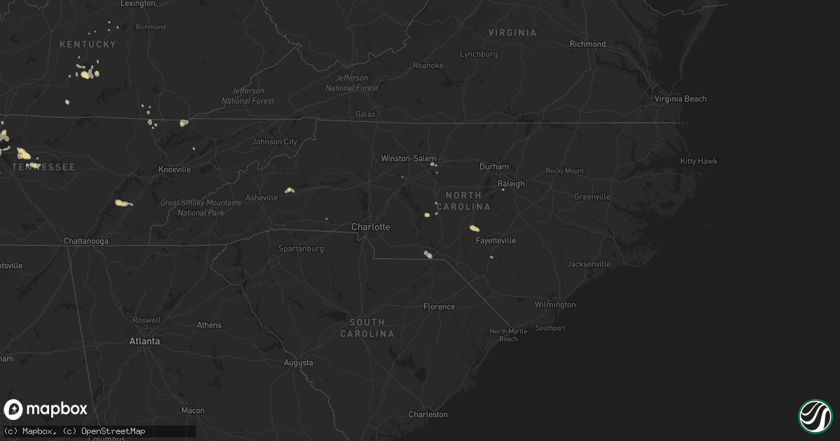
Hail Map in North Carolina on August 27, 2016
Get this storm
August 27 map
$229
one time, instant access
Download today. No call, no setup
Keep the $229
Bought the map and want the full workflow? Apply the entire $229 to a subscription within 7 days. None of it is wasted.
Every map, not just this one
This buys you this map. Subscription and you get every map we run, in the markets you choose from a few cities to whole states to nationwide. Plus real-time alerts the moment a storm fires.
Contact data
Name, contact info, occupancy, even credit band for addresses in the footprint. You go from where it hit to who to call.
Become the source they trust
Unlimited branding weather history reports on demand. You already have the documented answer ready for the property owner, and you are the one who showed up with it.
Property data and RoofTrace estimates
Pull up any address you have got, its value and the exact code rules for that jurisdiction, straight from One Click Code. Then RoofTrace estimates the squares, pitch, and roof value, priced the way you price.
Storm reports in North Carolina
North Carolina
| Date | Description |
|---|---|
| 08/27/20165:50 PM CDT | Trees down ene of marshall... Nc. |
| 08/27/20165:02 PM CDT | Trees down off fallston rd in shelby... Nc. |
| 08/27/20164:45 PM CDT | Trees and power lines down along highway 18 on east side of shelby. |
| 08/27/20164:38 PM CDT | One tree down on hastings hill road. . |
| 08/27/20164:36 PM CDT | Spotter reports several trees down on powerlines on hwy 18. |
| 08/27/20164:30 PM CDT | Small limbs down on piedmont avenue and cansler street. |
| 08/27/20164:30 PM CDT | Power-lines blown down near montgomery memorial hospital. |
| 08/27/20164:27 PM CDT | One tree was reported down on cocoa drive... Near woodedge drive. |
| 08/27/20164:25 PM CDT | Reports of mulitple trees and powerlines blown down across central gaston county including dallas...center city...and gastonia. |
| 08/27/20164:25 PM CDT | A few trees and large limbs blown down and a few reports of power outages. |
| 08/27/20164:25 PM CDT | Tree down in pleasant garden community along highway 70 and river road. |
| 08/27/20164:23 PM CDT | Media reports tree down on house in north cove. |
| 08/27/20164:20 PM CDT | One tree was blown down near the intersection of nc highway 52 and old us 52. . |
| 08/27/20164:16 PM CDT | One tree was reported down near the intersection of highway 731 and highway 52. . |
| 08/27/20164:10 PM CDT | Trees down on veterans drive in marion. |
| 08/27/20163:30 PM CDT | Small tree limbs blown down. |
| 08/27/20163:30 PM CDT | Power-lines blown down near montgomery memorial hospital. |
| 08/27/20163:08 PM CDT | Power-lines were blown down. . |
| 08/27/20163:00 PM CDT | Trees down along river road at highway 18. |
| 08/27/20162:58 PM CDT | Multiple trees down near downtown troutman... Nc. |
| 08/27/20162:21 PM CDT | One tree down on a residence on lakeview drive. |
| 08/27/20162:15 PM CDT | One tree down blocking the road at the 300 block of holly springs rd. Time estimated by radar. |
| 08/27/20162:08 PM CDT | Public reported trees down on millbridge rd near china grove |
| 08/27/20161:55 PM CDT | Trained spotter reported a tree down on sides rd in rockwell |
All States Impacted by Hail Map on August 27, 2016
Cities Impacted by Hail Map on August 27, 2016
- Lutts, TN
- Olivehill, TN
- Watson, MN
- Milan, MN
- Elk City, KS
- Buffalo, OK
- Wichita Falls, TX
- Northwood, ND
- Hatton, ND
- Reynolds, ND
- Leoti, KS
- Geneseo, IL
- Osco, IL
- Gurley, AL
- Paint Rock, AL
- Hohenwald, TN
- Harrold, TX
- Springfield, OH
- New Carlisle, OH
- Weinert, TX
- Rochester, TX
- Hereford, TX
- Eureka, KS
- La Mesa, NM
- Anthony, NM
- Greensburg, KY
- Campbellsville, KY
- Richfield, KS
- Okeene, OK
- Harrodsburg, KY
- Blissfield, MI
- Lebanon, TN
- Watertown, TN
- Hendrum, MN
- Osgood, IN
- Batesville, IN
- Napoleon, IN
- Greensburg, IN
- Athens, TN
- Decatur, TN
- Lakin, KS
- Summertown, TN
- Tompkinsville, KY
- Brookville, IN
- Shevlin, MN
- Solway, MN
- Bagley, MN
- Park Rapids, MN
- Laporte, MN
- Asheboro, NC
- Conde, SD
- Texhoma, OK
- Miami, TX
- Walters, OK
- Marietta, MN
- Revillo, SD
- South Shore, SD
- Marvin, SD
- Montevideo, MN
- Perley, MN
- Old Fort, NC
- Marion, NC
- Perryton, TX
- Hillsboro, ND
- Holliday, TX
- Thompson, ND
- Arvilla, ND
- Emerado, ND
- Larimore, ND
- Renville, MN
- Appleton, MN
- Danube, MN
- Olivia, MN
- Clara City, MN
- Dawson, MN
- Maynard, MN
- Prinsburg, MN
- Madison, MN
- Raymond, MN
- Blomkest, MN
- Lake Lillian, MN
- Waubay, SD
- Bellingham, MN
- Milbank, SD
- Breckenridge, MN
- Rothsay, MN
- Grafton, ND
- Fargo, ND
- Moorhead, MN
- West Fargo, ND
- Kindred, ND
- Franklin, TN
- Primm Springs, TN
- Duke, OK
- Glyndon, MN
- Felton, MN
- Columbia, KY
- Fairview, TN
- White Bluff, TN
- Kingston Springs, TN
- Harwood, ND
- Georgetown, MN
- Johnson, KS
- Kent, MN
- Spearman, TX
- Stinnett, TX
- Ulen, MN
- Borup, MN
- Hawley, MN
- Hitterdal, MN
- Stratford, TX
- Satanta, KS
- Lake Park, MN
- Andover, SD
- Nashville, TN
- Watertown, SD
- Westport, IN
- Butlerville, IN
- North Vernon, IN
- Santa Teresa, NM
- Sunland Park, NM
- El Paso, TX
- Bristol, SD
- Webster, SD
- Horace, ND
- Sharon Springs, KS
- Walcott, ND
- Arapahoe, CO
- Weskan, KS
- Morven, NC
- Wheaton, MN
- Gruver, TX
- Labolt, SD
- Seymour, TX
- Clifford, ND
- Kit Carson, CO
- Foxhome, MN
- Fergus Falls, MN
- Sunman, IN
- Brentford, SD
- Mellette, SD
- Haskell, TX
- Cottontown, TN
- Portland, TN
- Cross Plains, TN
- Las Cruces, NM
- Hillsboro, NM
- Yates Center, KS
- Randleman, NC
- Russell Springs, KY
- Dunnville, KY
- Winona, KS
- Buxton, ND
- Cummings, ND
- Caledonia, ND
- Mayville, ND
- Ada, MN
- Tribune, KS
- Canadian, TX
- Arnett, OK
- Sisseton, SD
- Rosholt, SD
- Cheyenne Wells, CO
- Troy, NC
- Dublin, TX
- Grandin, ND
- Duncan, OK
- Comanche, OK
- Booker, TX
- Bowling Green, OH
- Pemberville, OH
- Wayne, OH
- Portage, OH
- Flagler, CO
- Cass Lake, MN
- Bena, MN
- Brookville, OH
- Lewisburg, OH
- Argusville, ND
- Hunter, ND
- Blanchard, ND
- Gardner, ND
- Galesburg, ND
- Jamestown, NC
- Greensboro, NC
- Durham, OK
- Hugo, CO
- Sylvester, TX
- Hoople, ND
- Leupp, AZ
- Mountain View, OK
- Davenport, ND
- Glen, MS
- Twin Valley, MN
- Murfreesboro, TN
- Vass, NC
- Cameron, NC
- Fort Bragg, NC
- Higgins, TX
- Follett, TX
- Savannah, TN
- Galion, OH
- Eaton, OH
- Ortley, SD
- Pierpont, SD
- Pegram, TN
- Ottawa, KS
- Saint Pauls, NC
- Brentwood, TN
- Rockingham, NC
- Speedwell, TN
- Liberty, KY
- Niota, TN
- Evensville, TN
- Monticello, IL
- Electra, TX
- Madison, TN
- Hermitage, TN
- Wolverton, MN
- Colfax, ND
- Walsh, CO
- Shattuck, OK
- Oak Harbor, OH
- Eden, TX
- Rule, TX
- Cordell, OK
- Fort Hancock, TX
- Pioneer, TN
- Ulysses, KS
- Ottawa Lake, MI
- Munday, TX
- Summit, SD
- Weatherford, OK
- Knifley, KY
- Auburntown, TN
- Liberty, TN
- Alexandria, TN
- Manter, KS
- Petrolia, TX
- Henrietta, TX
- Pembroke, KY
- Hopkinsville, KY
- Florence, SD
- Lipscomb, TX
- Crawford, OK
- Springfield, KY
- Milton, TN
- Cumberland Gap, TN
- Twin Brooks, SD
- Stockholm, SD
- Warrensburg, IL
- Old Hickory, TN
- Mount Juliet, TN
- Goodlettsville, TN
- Hendersonville, TN
- Gallatin, TN
- Wahpeton, ND
- Christine, ND
- Winfield, TN
- Temple, OK
- East Alton, IL
- Lexington, NC
- Truth Or Consequences, NM
- Cloudcroft, NM
- Star, NC
- Bradley, SD
- Newcomb, TN
- Lawrenceburg, TN
- Socorro, NM
- Wallace, SD
- Ranger, TX
- Monroe, MI
- Santa Fe, TN
- Throckmorton, TX
- Crystal, ND
- Lambertville, MI
- Temperance, MI
- Arriba, CO
- Edmonton, KY
- Lathrop, MO
- Williamsburg, KY
- Pine Knot, KY
- Halstad, MN
- Decatur, IL
- Whitley City, KY
- Isabella, OK
- Blaine, TN
- Rutledge, TN
- Lyles, TN
- Sacred Heart, MN
- Thomas, OK
- Raleigh, NC
- Apex, NC
- Argenta, IL
- Oreana, IL
- Shelby, NC
- Peever, SD
- Oak Grove, KY
- Carnegie, OK
- Sheridan Lake, CO
- Saint Thomas, ND
- Goree, TX
- Oberlin, KS
- Herndon, KS
- Minto, ND
- Mekinock, ND
- Grand Forks Afb, ND


