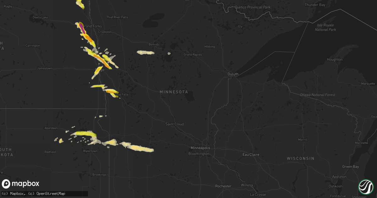
Hail Map in Minnesota on August 27, 2016
Get this storm
August 27 map
$229
one time, instant access
Download today. No call, no setup
Keep the $229
Bought the map and want the full workflow? Apply the entire $229 to a subscription within 7 days. None of it is wasted.
Every map, not just this one
This buys you this map. Subscription and you get every map we run, in the markets you choose from a few cities to whole states to nationwide. Plus real-time alerts the moment a storm fires.
Contact data
Name, contact info, occupancy, even credit band for addresses in the footprint. You go from where it hit to who to call.
Become the source they trust
Unlimited branding weather history reports on demand. You already have the documented answer ready for the property owner, and you are the one who showed up with it.
Property data and RoofTrace estimates
Pull up any address you have got, its value and the exact code rules for that jurisdiction, straight from One Click Code. Then RoofTrace estimates the squares, pitch, and roof value, priced the way you price.
Storm reports in Minnesota
Minnesota
| Date | Description |
|---|---|
| 08/27/20164:56 PM CDT | A local report indicates 1.00 inch wind near 1 NW FOXHOME |
| 08/27/20163:05 PM CDT | Hail up to golfball size at county road 16 and 270th avenue. Drifts of hail up to 1 ft on edge of road with hail covering road. Crop damage due to hail. |
| 08/27/20162:57 PM CDT | Hail covering the ground. |
| 08/27/20162:53 PM CDT | A local report indicates 1.00 inch wind near 8 N EVERDELL |
| 08/27/20161:55 PM CDT | Report posted via social media. Time estimated based on radar. |
| 08/27/20161:20 PM CDT | Pea to quarter size hail in north moorhead. |
| 08/27/20165:25 AM CDT | Multiple trees down. |
| 08/26/20168:18 PM CDT | Measured hail well after it had fallen. |
| 08/26/20167:27 PM CDT | A local report indicates 1.50 inch wind near 1 SE PERLEY |
All States Impacted by Hail Map on August 27, 2016
Cities Impacted by Hail Map on August 27, 2016
- Lutts, TN
- Olivehill, TN
- Watson, MN
- Milan, MN
- Elk City, KS
- Buffalo, OK
- Wichita Falls, TX
- Northwood, ND
- Hatton, ND
- Reynolds, ND
- Leoti, KS
- Geneseo, IL
- Osco, IL
- Gurley, AL
- Paint Rock, AL
- Hohenwald, TN
- Harrold, TX
- Springfield, OH
- New Carlisle, OH
- Weinert, TX
- Rochester, TX
- Hereford, TX
- Eureka, KS
- La Mesa, NM
- Anthony, NM
- Greensburg, KY
- Campbellsville, KY
- Richfield, KS
- Okeene, OK
- Harrodsburg, KY
- Blissfield, MI
- Lebanon, TN
- Watertown, TN
- Hendrum, MN
- Osgood, IN
- Batesville, IN
- Napoleon, IN
- Greensburg, IN
- Athens, TN
- Decatur, TN
- Lakin, KS
- Summertown, TN
- Tompkinsville, KY
- Brookville, IN
- Shevlin, MN
- Solway, MN
- Bagley, MN
- Park Rapids, MN
- Laporte, MN
- Asheboro, NC
- Conde, SD
- Texhoma, OK
- Miami, TX
- Walters, OK
- Marietta, MN
- Revillo, SD
- South Shore, SD
- Marvin, SD
- Montevideo, MN
- Perley, MN
- Old Fort, NC
- Marion, NC
- Perryton, TX
- Hillsboro, ND
- Holliday, TX
- Thompson, ND
- Arvilla, ND
- Emerado, ND
- Larimore, ND
- Renville, MN
- Appleton, MN
- Danube, MN
- Olivia, MN
- Clara City, MN
- Dawson, MN
- Maynard, MN
- Prinsburg, MN
- Madison, MN
- Raymond, MN
- Blomkest, MN
- Lake Lillian, MN
- Waubay, SD
- Bellingham, MN
- Milbank, SD
- Breckenridge, MN
- Rothsay, MN
- Grafton, ND
- Fargo, ND
- Moorhead, MN
- West Fargo, ND
- Kindred, ND
- Franklin, TN
- Primm Springs, TN
- Duke, OK
- Glyndon, MN
- Felton, MN
- Columbia, KY
- Fairview, TN
- White Bluff, TN
- Kingston Springs, TN
- Harwood, ND
- Georgetown, MN
- Johnson, KS
- Kent, MN
- Spearman, TX
- Stinnett, TX
- Ulen, MN
- Borup, MN
- Hawley, MN
- Hitterdal, MN
- Stratford, TX
- Satanta, KS
- Lake Park, MN
- Andover, SD
- Nashville, TN
- Watertown, SD
- Westport, IN
- Butlerville, IN
- North Vernon, IN
- Santa Teresa, NM
- Sunland Park, NM
- El Paso, TX
- Bristol, SD
- Webster, SD
- Horace, ND
- Sharon Springs, KS
- Walcott, ND
- Arapahoe, CO
- Weskan, KS
- Morven, NC
- Wheaton, MN
- Gruver, TX
- Labolt, SD
- Seymour, TX
- Clifford, ND
- Kit Carson, CO
- Foxhome, MN
- Fergus Falls, MN
- Sunman, IN
- Brentford, SD
- Mellette, SD
- Haskell, TX
- Cottontown, TN
- Portland, TN
- Cross Plains, TN
- Las Cruces, NM
- Hillsboro, NM
- Yates Center, KS
- Randleman, NC
- Russell Springs, KY
- Dunnville, KY
- Winona, KS
- Buxton, ND
- Cummings, ND
- Caledonia, ND
- Mayville, ND
- Ada, MN
- Tribune, KS
- Canadian, TX
- Arnett, OK
- Sisseton, SD
- Rosholt, SD
- Cheyenne Wells, CO
- Troy, NC
- Dublin, TX
- Grandin, ND
- Duncan, OK
- Comanche, OK
- Booker, TX
- Bowling Green, OH
- Pemberville, OH
- Wayne, OH
- Portage, OH
- Flagler, CO
- Cass Lake, MN
- Bena, MN
- Brookville, OH
- Lewisburg, OH
- Argusville, ND
- Hunter, ND
- Blanchard, ND
- Gardner, ND
- Galesburg, ND
- Jamestown, NC
- Greensboro, NC
- Durham, OK
- Hugo, CO
- Sylvester, TX
- Hoople, ND
- Leupp, AZ
- Mountain View, OK
- Davenport, ND
- Glen, MS
- Twin Valley, MN
- Murfreesboro, TN
- Vass, NC
- Cameron, NC
- Fort Bragg, NC
- Higgins, TX
- Follett, TX
- Savannah, TN
- Galion, OH
- Eaton, OH
- Ortley, SD
- Pierpont, SD
- Pegram, TN
- Ottawa, KS
- Saint Pauls, NC
- Brentwood, TN
- Rockingham, NC
- Speedwell, TN
- Liberty, KY
- Niota, TN
- Evensville, TN
- Monticello, IL
- Electra, TX
- Madison, TN
- Hermitage, TN
- Wolverton, MN
- Colfax, ND
- Walsh, CO
- Shattuck, OK
- Oak Harbor, OH
- Eden, TX
- Rule, TX
- Cordell, OK
- Fort Hancock, TX
- Pioneer, TN
- Ulysses, KS
- Ottawa Lake, MI
- Munday, TX
- Summit, SD
- Weatherford, OK
- Knifley, KY
- Auburntown, TN
- Liberty, TN
- Alexandria, TN
- Manter, KS
- Petrolia, TX
- Henrietta, TX
- Pembroke, KY
- Hopkinsville, KY
- Florence, SD
- Lipscomb, TX
- Crawford, OK
- Springfield, KY
- Milton, TN
- Cumberland Gap, TN
- Twin Brooks, SD
- Stockholm, SD
- Warrensburg, IL
- Old Hickory, TN
- Mount Juliet, TN
- Goodlettsville, TN
- Hendersonville, TN
- Gallatin, TN
- Wahpeton, ND
- Christine, ND
- Winfield, TN
- Temple, OK
- East Alton, IL
- Lexington, NC
- Truth Or Consequences, NM
- Cloudcroft, NM
- Star, NC
- Bradley, SD
- Newcomb, TN
- Lawrenceburg, TN
- Socorro, NM
- Wallace, SD
- Ranger, TX
- Monroe, MI
- Santa Fe, TN
- Throckmorton, TX
- Crystal, ND
- Lambertville, MI
- Temperance, MI
- Arriba, CO
- Edmonton, KY
- Lathrop, MO
- Williamsburg, KY
- Pine Knot, KY
- Halstad, MN
- Decatur, IL
- Whitley City, KY
- Isabella, OK
- Blaine, TN
- Rutledge, TN
- Lyles, TN
- Sacred Heart, MN
- Thomas, OK
- Raleigh, NC
- Apex, NC
- Argenta, IL
- Oreana, IL
- Shelby, NC
- Peever, SD
- Oak Grove, KY
- Carnegie, OK
- Sheridan Lake, CO
- Saint Thomas, ND
- Goree, TX
- Oberlin, KS
- Herndon, KS
- Minto, ND
- Mekinock, ND
- Grand Forks Afb, ND


