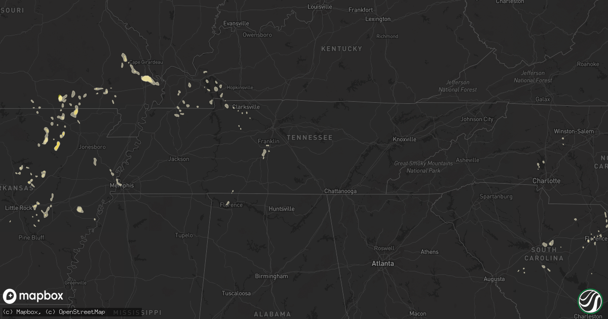
Hail Map in Tennessee on August 26, 2023
Get this storm
August 26 map
$229
one time, instant access
Download today. No call, no setup
Keep the $229
Bought the map and want the full workflow? Apply the entire $229 to a subscription within 7 days. None of it is wasted.
Every map, not just this one
This buys you this map. Subscription and you get every map we run, in the markets you choose from a few cities to whole states to nationwide. Plus real-time alerts the moment a storm fires.
Contact data
Name, contact info, occupancy, even credit band for addresses in the footprint. You go from where it hit to who to call.
Become the source they trust
Unlimited branding weather history reports on demand. You already have the documented answer ready for the property owner, and you are the one who showed up with it.
Property data and RoofTrace estimates
Pull up any address you have got, its value and the exact code rules for that jurisdiction, straight from One Click Code. Then RoofTrace estimates the squares, pitch, and roof value, priced the way you price.
Storm reports in Tennessee
Tennessee
| Date | Description |
|---|---|
| 08/26/20236:15 PM CDT | Facebook photo showed a tree down on a house in clifton. |
| 08/26/20235:40 PM CDT | Facebook photo showed large oak tree down on home in hohenwald. |
| 08/26/20234:56 PM CDT | Severe thunderstorm winds damaged the roof of a shell gas station along main street in spring hill. Part of the roof fell on a car that was parked at a gas pump. No inj |
| 08/26/20234:49 PM CDT | Severe thunderstorm winds downed numerous trees across dickson county. Time estimated via radar. |
| 08/26/20234:40 PM CDT | Facebook photos showed a couple of trees were blown down around spring hill. |
| 08/26/20234:35 PM CDT | Corrects previous flood report from 6 ssw franklin. Tree snapped on keystone dr. Time estimated. |
| 08/26/20234:25 PM CDT | Power lines down and roof damage reported at the davy crockett motel along east gaines street. |
| 08/26/20234:25 PM CDT | Numerous trees down in lawrenceburg... Mostly north of the public square. 1...878 customers without power in the area. Time estimated. |
| 08/26/20234:25 PM CDT | Corrects previous tstm wnd dmg report from lawrenceburg. Numerous trees down in lawrenceburg... Mostly north of the public square around liberty ave. One tree fell onto |
| 08/26/20233:53 PM CDT | Severe thunderstorm winds downed numerous trees across portions of stewart county. Time estimated via radar. |
All States Impacted by Hail Map on August 26, 2023
Cities Impacted by Hail Map on August 26, 2023
- Mokane, MO
- Fulton, MO
- Jerseyville, IL
- Grafton, IL
- Portage Des Sioux, MO
- Alton, MO
- Wichita Falls, TX
- Sheppard Afb, TX
- Waurika, OK
- Duncan, OK
- Marlow, OK
- Couch, MO
- Saint Amant, LA
- Irwin, ID
- Doniphan, MO
- Florence, SC
- Batesville, AR
- Sidney, AR
- Cave City, AR
- Horseshoe Bend, AR
- Evening Shade, AR
- Poplar Bluff, MO
- Martin, TN
- Dresden, TN
- Montello, NV
- Oakley, ID
- Benton, KY
- Mammoth Spring, AR
- Ravenden, AR
- Dickson, TN
- Swan Valley, ID
- Pocahontas, AR
- Ravenden Springs, AR
- Warm Springs, AR
- Malad City, ID
- Myrtle, MO
- Laurinburg, NC
- Sturkie, AR
- Cadiz, KY
- Latta, SC
- Smithville, AR
- Strawberry, AR
- Baton Rouge, LA
- Wingo, KY
- Sedalia, KY
- Fulton, KY
- Sulphur Rock, AR
- Greenville, AL
- Fancy Farm, KY
- Fair Grove, MO
- Strafford, MO
- Burgaw, NC
- Willard, NC
- Marshfield, MO
- Williamsville, MO
- Franklinton, LA
- Amite, LA
- Palmyra, TN
- Judsonia, AR
- Searcy, AR
- Charlotte, TN
- Kuttawa, KY
- Sikeston, MO
- Benton, MO
- Oran, MO
- Charleston, MO
- Bauxite, AR
- England, AR
- Marble Hill, MO
- Chaffee, MO
- Whitewater, MO
- Advance, MO
- Cherokee Village, AR
- Hardy, AR
- Romance, AR
- Mount Vernon, AR
- Williford, AR
- El Paso, AR
- Napoleonville, LA
- Moody, MO
- Rowland, NC
- Mountain View, AR
- Newark, AR
- Charlotte, AR
- Cord, AR
- Salem, AR
- West Plains, MO
- Winnfield, LA
- Quitman, AR
- Ash Flat, AR
- Darlington, SC
- Currie, NC
- Driggs, ID
- Tetonia, ID
- Marion, SC
- Broseley, MO
- Fisk, MO
- Enterprise, OR
- Saint James, LA
- Springfield, LA
- Hickory, KY
- Boaz, KY
- Caulfield, MO
- South Fulton, TN
- Timmonsville, SC
- Cairo, IL
- Dover, TN
- Big Rock, TN
- Indian Mound, TN
- Thompsons Station, TN
- Spring Hill, TN
- Qulin, MO
- Mayfield, KY
- Gatewood, MO
- New Concord, KY
- Murray, KY
- Cunningham, TN
- Gonzales, LA
- Prairieville, LA
- Elizabethtown, IL
- Franklin, TN
- Bertrand, MO
- Hazel, KY
- Woodlawn, TN
- Clarksville, TN
- Glenallen, MO
- Patton, MO
- Beebe, AR
- Harrisburg, AR
- Fremont, MO
- Columbia, TN
- Clio, SC
- McColl, SC
- Hartman, AR
- Clarksville, AR
- Ryan, OK
- Ririe, ID
- Tiline, KY
- Grand Rivers, KY
- Smithland, KY
- Mount Pleasant, AR
- Grandin, MO
- Eddyville, KY
- McBee, SC
- Tishomingo, OK
- Davis, OK
- Sulphur, OK
- Dougherty, OK
- Springer, OK
- Ardmore, OK
- Turrell, AR
- Lonoke, AR
- Florence, AL
- Montpelier, ID
- Carlisle, AR
- Salley, SC
- Wagener, SC
- Dalzell, SC
- Rembert, SC
- Burley, ID
- Rose Bud, AR
- Scott, AR
- Saint Matthews, SC
- Pearl River, LA
- Snowville, UT
- Des Arc, AR
- Heber Springs, AR
- Soda Springs, ID
- Lugoff, SC
- Columbia, SC
- Rogersville, MO
- McKenzie, AL
- Georgiana, AL
- Hazen, AR
- Burns, OR
- Biscoe, AR
- Greenbrier, AR
- Damascus, AR
- Tucker, AR
- Loveland, OK
- Effingham, SC
- Salters, SC
- Marion, AR
- Ratliff City, OK
- Iron City, TN
- Howell, UT
- Comanche, TX
- Mocksville, NC
- Trumann, AR
- Jessieville, AR
- Mountain Pine, AR
- Pangburn, AR
- Kuna, ID
- Denver, NC
- Lynchburg, SC
- Stanley, NC
- Mooresville, NC
- Orangeburg, SC
- Altheimer, AR
- West Memphis, AR
- Richland, GA
- Aubrey, AR
- Marianna, AR
- Moro, AR
- Memphis, TN
- Helena, AR
- West Helena, AR
- Bumpus Mills, TN
- Boise, ID


