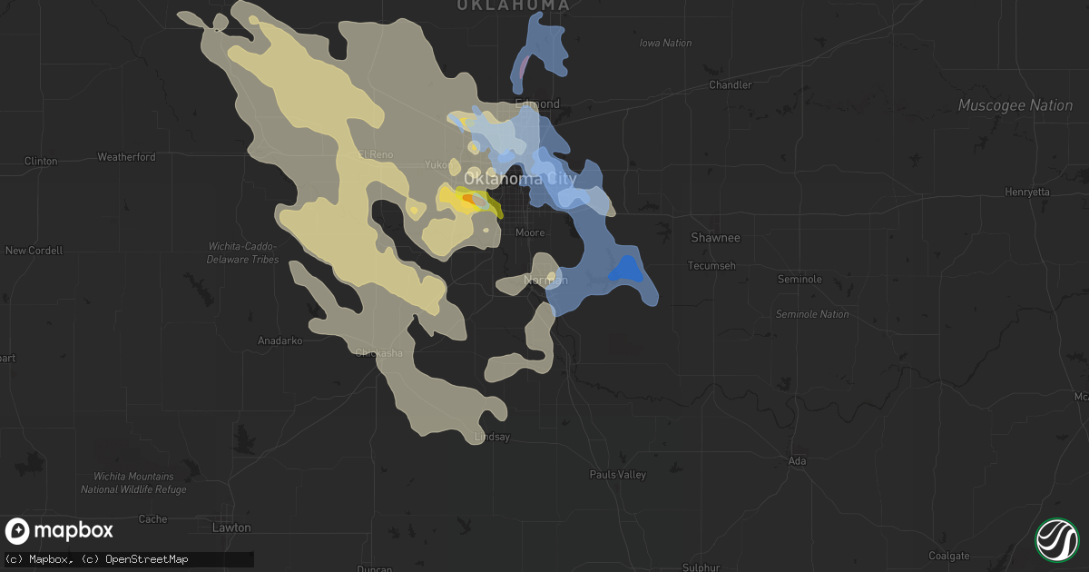
Hail Map in Norman, OK on August 26, 2019
Get this storm
August 26 map
$229
one time, instant access
Download today. No call, no setup
Keep the $229
Bought the map and want the full workflow? Apply the entire $229 to a subscription within 7 days. None of it is wasted.
Every map, not just this one
This buys you this map. Subscription and you get every map we run, in the markets you choose from a few cities to whole states to nationwide. Plus real-time alerts the moment a storm fires.
Contact data
Name, contact info, occupancy, even credit band for addresses in the footprint. You go from where it hit to who to call.
Become the source they trust
Unlimited branding weather history reports on demand. You already have the documented answer ready for the property owner, and you are the one who showed up with it.
Property data and RoofTrace estimates
Pull up any address you have got, its value and the exact code rules for that jurisdiction, straight from One Click Code. Then RoofTrace estimates the squares, pitch, and roof value, priced the way you price.
Storm reports in Norman, OK
Norman, OK
| Date | Description |
|---|---|
| 08/25/201910:45 PM CDT | Late report. Trees down in little axe area. |
| 08/25/201910:25 PM CDT | Multiple power lines reported around norman - 900 barkley... 3000 ne 96th... 1000 montgomery... 600 e. Vicksburg... 1800 yorktown... 500 sinclair. Grass fires also repo |
| 08/25/201910:20 PM CDT | Multiple trees down at lindsay and candlewood roads. |
| 08/25/201910:19 PM CDT | Spotter reports trees down. |
| 08/25/201910:18 PM CDT | Spotternetwork report. |
| 08/25/201910:15 PM CDT | Several boats damaged or destroyed at the crystal cove marina on lake thunderbird. Time estimated. |
| 08/25/20199:55 PM CDT | Ham radio report. |
| 08/25/20199:53 PM CDT | Spotter report... Estimate. |
All States Impacted by Hail Map on August 26, 2019
All Cities Impacted by Hail Map on August 26, 2019
- Saint Jo, TX
- Leon, OK
- Yukon, OK
- Wheatland, OK
- Mustang, OK
- Oklahoma City, OK
- Jansen, NE
- Commerce, OK
- Miami, OK
- Quapaw, OK
- North Miami, OK
- Picher, OK
- Wyandotte, OK
- Tuttle, OK
- Bartlett, KS
- Kingfisher, OK
- Okarche, OK
- Sutton, NE
- Harvard, NE
- Grafton, NE
- Saronville, NE
- Shickley, NE
- Geneva, NE
- Drexel, MO
- Adrian, MO
- Fairbury, NE
- Elmore City, OK
- Tussy, OK
- Hennepin, OK
- Foster, OK
- Weston, CO
- Beattie, KS
- Frankfort, KS
- Hinton, OK
- Hydro, OK
- Kirbyville, MO
- Union City, OK
- Binger, OK
- Amber, OK
- Minco, OK
- Anadarko, OK
- Geary, OK
- Calumet, OK
- Watonga, OK
- El Reno, OK
- Pocasset, OK
- Basehor, KS
- Kansas City, KS
- Bonner Springs, KS
- Gracemont, OK
- Pawhuska, OK
- Owasso, OK
- Claremore, OK
- Tulsa, OK
- Catoosa, OK
- Saint Joe, AR
- Harrison, AR
- Omaha, AR
- Hollister, MO
- Hasty, AR
- Everton, AR
- Lead Hill, AR
- Western Grove, AR
- Bois D Arc, MO
- Republic, MO
- Billings, MO
- Everton, MO
- Marionville, MO
- Ash Grove, MO
- Halltown, MO
- Marlow, OK
- Grandin, MO
- Harviell, MO
- Poplar Bluff, MO
- Neelyville, MO
- Greenfield, MO
- South Greenfield, MO
- Marshfield, MO
- Clayton, OK
- Blanco, OK
- Hartshorne, OK
- Tuskahoma, OK
- Mayetta, KS
- Cement, OK
- Burbank, OK
- Fairfax, OK
- Barnsdall, OK
- Wynona, OK
- Skiatook, OK
- Bartlesville, OK
- Ponca City, OK
- Shidler, OK
- Bradley, OK
- Ninnekah, OK
- Independence, KS
- Ardmore, OK
- Wilson, OK
- Liberty, KS
- Coffeyville, KS
- Butler, MO
- Ottawa, KS
- Pomona, KS
- Gassville, AR
- Mountain Home, AR
- Midway, AR
- Pauls Valley, OK
- Stratford, OK
- Welch, OK
- Carnegie, OK
- Rich Hill, MO
- Galena, KS
- Riverton, KS
- Baxter Springs, KS
- Columbus, KS
- Scammon, KS
- Diller, NE
- Mount Vernon, MO
- Aurora, MO
- Land O'Lakes, FL
- Niangua, MO
- Elk City, KS
- Lone Grove, OK
- Baldwin City, KS
- Lawrence, KS
- Duncan, OK
- Loco, OK
- Collinsville, OK
- Lawton, OK
- Cyril, OK
- Rush Springs, OK
- Elgin, OK
- Fletcher, OK
- Overbrook, OK
- Burneyville, OK
- Marietta, OK
- Lutz, FL
- Pryor, OK
- Sheldon, MO
- Lamar, MO
- Edna, KS
- Locust Grove, OK
- Medicine Park, OK
- Edmond, OK
- Piedmont, OK
- Vian, OK
- Greenfield, OK
- Noble, MO
- Lindsay, OK
- Spencer, OK
- Choctaw, OK
- Harrah, OK
- Newalla, OK
- Jones, OK
- Milo, MO
- El Dorado Springs, MO
- Walker, MO
- Nevada, MO
- Norman, OK
- Topeka, KS
- Hoyt, KS
- Rattan, OK
- Nashoba, OK
- Snow, OK
- Chickasha, OK
- Tonganoxie, KS
- McLouth, KS
- Verona, MO
- Lockwood, MO
- Jerico Springs, MO
- Golden City, MO
- Jacksboro, TX
- Bryson, TX
- Ringling, OK
- Broken Arrow, OK
- Branson, MO
- Walnut Shade, MO
- Fairland, OK
- Oologah, OK
- Bethany, OK
- Webbers Falls, OK
- Porum, OK
- Stigler, OK
- Quinton, OK
- Hennessey, OK
- Tahlequah, OK
- Proctor, OK
- Mccurtain, OK
- Lexington, OK
- Stockton, MO
- Ratliff City, OK
- Fontana, KS
- Parker, KS
- Osawatomie, KS
- Bowie, TX
- Mountain View, OK
- Plymouth, NE
- Endicott, NE
- Daykin, NE
- Western, NE
- Hanover, KS
- Bremen, KS
- Steele City, NE
- Odell, NE
- Hollenberg, KS
- Marysville, KS
- Wymore, NE
- Beatrice, NE
- Gravois Mills, MO
- Rocky Mount, MO
- Stoutland, MO
- Richland, MO
- Mulberry, AR
- Wanette, OK
- Bellevue, TX
- Sunset, TX
- Graham, TX
- Amoret, MO
- Ava, MO
- Squires, MO
- Wagoner, OK
- Nowata, OK
- Uniontown, AR
- Muldrow, OK
- Paola, KS
- Bunch, OK
- Graford, TX
- Broken Bow, OK
- Overland Park, KS
- Bucyrus, KS
- De Soto, KS
- Lenexa, KS
- Gardner, KS
- New Century, KS
- Spring Hill, KS
- Linwood, KS
- Shawnee, KS
- Olathe, KS
- Montague, TX
- Clay Center, NE
- Coalgate, OK
- Alex, OK
- Newcastle, OK
- Blanchard, OK
- Cashion, OK
- Verden, OK
- La Cygne, KS
- Ramona, OK
- Bruner, MO
- Fordland, MO
- Rogersville, MO
- Oketo, KS
- Alexandria, NE
- Ohiowa, NE
- Tobias, NE
- Strang, NE
- Blue Springs, NE
- Mcalester, OK
- Shawnee, OK
- Mcloud, OK
- Tecumseh, OK
- Hulbert, OK
- Chouteau, OK
- Peggs, OK
- Palm City, FL
- Port Saint Lucie, FL
- Harwood, MO
- Richards, MO
- Circleville, KS
- Noble, OK
- Hartman, AR
- Havensville, KS
- Holton, KS
- Bull Shoals, AR
- Lake Wales, FL
- Leedey, OK
- Schell City, MO
- Cookson, OK
- Sallisaw, OK
- Talala, OK
- Porter, OK
- Coweta, OK
- Spokane, MO
- Galena, MO
- Reeds Spring, MO
- Healdton, OK
- Rockville, MO
- Wister, OK
- Amsterdam, MO
- Tunas, MO
- Dadeville, MO
- Arcola, MO
- Seymour, MO
- Henrietta, TX
- Onaga, KS
- Foster, MO
- Springer, OK
- Powersite, MO
- Atoka, OK
- Dundee, FL
- Haines City, FL
- Denison, KS
- Jay, OK
- Colcord, OK
- Alvord, TX
- Decatur, TX
- Nocona, TX
- Muenster, TX
- Stover, MO
- Van Buren, MO
- Fremont, MO
- Gentry, AR
- Siloam Springs, AR
- Gravette, AR
- Decatur, AR
- Maysville, AR
- Meriden, KS
- Sulphur, OK
- Mill Creek, OK
- Chico, TX
- Bruning, NE
- Milligan, NE
- Thornfield, MO
- Wasola, MO
- Gainesville, TX
- Sanger, TX
- Buffalo, MO
- Long Lane, MO
- Elkland, MO
- Half Way, MO
- Urbana, MO
- Louisburg, MO
- Greenleaf, KS
- Centralia, KS
- Vermillion, KS
- Highlandville, MO
- Archie, MO
- Forsyth, MO
- Ponce De Leon, MO
- Clever, MO
- Rockaway Beach, MO
- Miller, MO
- Brookline, MO
- Nixa, MO
- Moundville, MO
- Bronaugh, MO
- Crane, MO
- Springfield, MO
- Louisburg, KS
- Appleton City, MO
- Stilwell, OK
- Thomas, OK
- Pleasanton, KS
- Prescott, KS
- Gainesville, MO
- Clarkridge, AR
- Sperry, OK
- Freeman, MO
- Cleveland, MO
- Doniphan, MO
- West Fork, AR
- Camdenton, MO
- Bluejacket, OK
- Soldier, KS
- Elizabeth, AR
- Carney, OK
- Wellston, OK
- Fort Gibson, OK
- Bixby, OK
- Adair, OK
- Braggs, OK
- Salina, OK
- Inola, OK
- Muskogee, OK
- Chelsea, OK
- Washington, OK
- Purcell, OK
- Fairmont, NE
- Edgar, NE
- Home, KS
- Swanton, NE
- Lebanon, MO
- Marland, OK
- Cole Camp, MO
- Keota, OK
- Warner, OK
- Macks Creek, MO
- Park Hill, OK
- Alma, AR
- Gamaliel, AR
- Clarksville, AR
- Wichita Falls, TX
- Valley Falls, KS
- Paoli, OK
- Centerville, KS
- Garnett, KS
- Mound City, KS
- Blue Eye, MO
- Rose, OK
- Barnes, KS
- Versailles, MO
- Mena, AR
- Gore, OK
- McCune, KS
- West Mineral, KS
- Goff, KS
- Corning, KS
- Delia, KS
- Madelia, MN
- Amboy, MN
- Vernon Center, MN
- Perry, OK
- Orlando, OK
- Mulhall, OK
- Crescent, OK
- Guthrie, OK
- Falcon, MO
- Grovespring, MO
- Lynchburg, MO
- Mountain Grove, MO
- Conway, MO
- Plato, MO
- Norwood, MO
- Macomb, MO
- Mansfield, MO
- Hartville, MO
- Anderson, MO
- Lowell, AR
- Springdale, AR
- South West City, MO
- Bentonville, AR
- Wesley, AR
- Pineville, MO
- Sulphur Springs, AR
- Cave Springs, AR
- Noel, MO
- Hiwasse, AR
- Centerton, AR
- Rogers, AR
- Lanagan, MO
- Bella Vista, AR
- Huntsville, AR
- Elkins, AR
- Tiff City, MO
- Grove, OK
- Hindsville, AR
- Fayetteville, AR
- Welling, OK
- Gans, OK
- Macomb, OK
- Ridgedale, MO
- Dixon, MO
- Crocker, MO
- Saint Robert, MO
- Fort Leonard Wood, MO
- Laquey, MO
- Newburg, MO
- Waynesville, MO
- Rolla, MO
- Aurora, NE
- Inland, NE
- Phillips, NE
- Giltner, NE
- Trumbull, NE
- Grand Island, NE
- Doniphan, NE
- Alda, NE
- Bradshaw, NE
- Benedict, NE
- Waco, NE
- Polk, NE
- York, NE
- McCool Junction, NE
- Stromsburg, NE
- Hampton, NE


