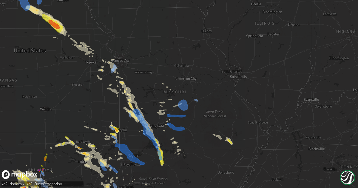
Hail Map in Missouri on August 26, 2019
Get this storm
August 26 map
$229
one time, instant access
Download today. No call, no setup
Keep the $229
Bought the map and want the full workflow? Apply the entire $229 to a subscription within 7 days. None of it is wasted.
Every map, not just this one
This buys you this map. Subscription and you get every map we run, in the markets you choose from a few cities to whole states to nationwide. Plus real-time alerts the moment a storm fires.
Contact data
Name, contact info, occupancy, even credit band for addresses in the footprint. You go from where it hit to who to call.
Become the source they trust
Unlimited branding weather history reports on demand. You already have the documented answer ready for the property owner, and you are the one who showed up with it.
Property data and RoofTrace estimates
Pull up any address you have got, its value and the exact code rules for that jurisdiction, straight from One Click Code. Then RoofTrace estimates the squares, pitch, and roof value, priced the way you price.
Storm reports in Missouri
Missouri
| Date | Description |
|---|---|
| 08/26/20195:51 PM CDT | Tree down on a car. |
| 08/26/20195:43 PM CDT | Tree down on cr450 and power line down on cr 461. |
| 08/26/20195:39 PM CDT | A local report indicates 1.00 inch wind near 7 NNE FARIDEALING |
| 08/26/20194:18 PM CDT | Tree down. |
| 08/26/20194:05 PM CDT | Corrects time of previous hail report from ridgedale. Picture via social media. Time estimated from radar. |
| 08/26/20193:50 PM CDT | Public report relayed by media partner of a tree into a home near branson off highway 160 and highway 248. |
| 08/26/20193:45 PM CDT | A power line and multiple trees down on keystone road near highway 160. Time estimated from radar. |
| 08/26/20193:43 PM CDT | Multiple trees and 2 powerlines downed off of reno springs road. Time estimated from radar. |
| 08/26/20193:40 PM CDT | Heavy damage to several metal outbuildings near highway 160. Time estimated from radar. |
| 08/26/20193:33 PM CDT | Nws storm survey found evidence of 80 to 85 mph winds causing severe damage to a large building at a business... With the damage facing to the south. Several large tree |
| 08/26/20193:30 PM CDT | Numerous large trees downed and business building damaged. Time estimated from radar. |
| 08/26/20193:20 PM CDT | Just lost a limb out of a post oak tree in my front yard. Probably 3 to 4 inches in width. Rain is sideways. |
| 08/26/20193:05 PM CDT | Delayed report via social media. Multiple trees down at a residence in billings. Time estimated from radar. |
| 08/26/20193:05 PM CDT | Delayed report via social media pictures. A couple farm outbuildings with roofs damaged or destroyed... Along with numerous trees in billings. Time estimated from radar |
| 08/26/20193:01 PM CDT | Delayed report via social media picture. Multiple large trees down in a residential yard. Time estimated from radar. |
| 08/26/20193:01 PM CDT | Several large trees down and small animal shed damaged. |
| 08/26/20193:00 PM CDT | Tree down and roof damage. |
| 08/26/20193:00 PM CDT | Delayed report of several trees uprooted northwest of billings. Time estimated from radar. |
| 08/26/20192:56 PM CDT | Delayed report via social media pictures. Two uprooted trees and wind gusts estimated to 60 mph. Time estimated from radar. |
| 08/26/20192:56 PM CDT | Numerous trees broken... Uprooted and snapped in half off of highway 96 near the interstate 44 exit in halltown. Time estimated from radar. |
| 08/26/20192:55 PM CDT | Also limbs blown down. |
| 08/26/20192:52 PM CDT | Pictures of multiple trees downed off of high street and elliot ave in northern aurora. |
| 08/26/20192:45 PM CDT | Tree down miller mo around 2:45 pm. |
| 08/26/20192:38 PM CDT | Delayed report. Multiple small limbs down and shingles blown off. Wind ripped a second story screen door open causing it to crash into a west facing window. Time estima |
| 08/26/20192:38 PM CDT | 5 miles north of halltown ne lawrence county wind speed estimated 60 miles per hour. 1 to 2 inch branches down. |
| 08/26/20192:34 PM CDT | Tree on residence in rolla on faulkner. No injuries reported. Trees also down in area of phelps health hospital in rolla. Time based on radar. |
| 08/26/20192:30 PM CDT | Damage to home... Outbuilding and trees uprooted. |
| 08/26/20192:30 PM CDT | Trees were down blocking highway 133 between swedeborg and richland in northern pulaski county... Mo. |
| 08/26/20192:30 PM CDT | Delayed report for 8 miles east of miller on highway dd. Pictures of house damage... Multiple outbuildings destroyed... And countless trees uprooted. Time estimated fro |
| 08/26/20192:29 PM CDT | 1 inch tree limbs broken; shingles blown off. |
| 08/26/20192:25 PM CDT | Multiple trees down and leaning power lines. The back of an outbuilding was also blown out. Damage is laying in the same direction. Time estimated from radar. |
| 08/26/20192:25 PM CDT | Large limb down in back yard. |
| 08/26/20192:20 PM CDT | Downed trees and damage to a roof in st. Robert. Numerous power outages. Time estimated from radar. |
| 08/26/20192:18 PM CDT | Picture of a tree downed onto a driveway east of greenfield. Time estimated from radar. |
| 08/26/20192:15 PM CDT | Several trees uprooted in west waynesville in old farm estates. |
| 08/26/20191:57 PM CDT | Wind gust estimated at 60 mph at mutten creek recreation area along stockton lake. |
| 08/26/20191:53 PM CDT | Delayed report. Multiple 3 inch tree limbs down at a residence 7 miles east of lamar. Wind gust estimates to 60 mph. Time estimated from radar. |
| 08/26/20191:48 PM CDT | 4 to 5 inch branches down e of jerico springs. |
| 08/26/20197:59 AM CDT | At 1258 PM CDT, severe thunderstorms were located along a line extending from near Smithton to 9 miles southwest of Stover to 7 miles west of Warsaw, moving east at 50 mph. HAZARD...60 mph wind gusts. SOURCE...Radar indicated. IMPACT...Expect damage to roofs, siding, and trees. Locations impacted include... Lake of The Ozarks... Truman Lake... Truman State Park... Lake of The Ozarks State Park... Eldon... Osage Beach... Versailles... Village of Four Seasons... Warsaw... Lake Ozark... Lincoln... Cole Camp... Stover... Laurie... Sunrise Beach... Linn Creek... Tuscumbia... Barnett... Syracuse... Gravois Mills... |
| 08/26/20197:55 AM CDT | At 1255 PM CDT, severe thunderstorms were located along a line extending from near Montrose to near Schell City to Nevada, moving southeast at 25 mph. HAZARD...60 mph wind gusts. SOURCE...Radar indicated. IMPACT...Expect damage to roofs, siding, and trees. Locations impacted include... Truman Lake... Nevada... El Dorado Springs... Appleton City... Osceola... Lowry City... Montevallo... Walker... Schell City... Jerico Springs... Roscoe... Vista... Metz... Harwood... Olympia... Horton... Caplinger Mills... Wagoner... Tiffin... Johnson City...This includes Interstate 49 between mile markers 86 and 107. |
| 08/26/20197:22 AM CDT | At 1222 PM CDT, severe thunderstorms were located along a line extending from near Sedalia to near Windsor to near Clinton, moving east at 70 mph. HAZARD...60 mph wind gusts. SOURCE...Radar indicated. IMPACT...Expect damage to roofs, siding, and trees. Locations impacted include... Truman Lake... Lake of The Ozarks... Truman State Park... Eldon... Versailles... Village of Four Seasons... Warsaw... Lincoln... Cole Camp... Stover... Laurie... Sunrise Beach... Barnett... Syracuse... Gravois Mills... Olean... Climax Springs... Ionia... Palo Pinto... Lakeview Heights... |
| 08/26/20197:13 AM CDT | At 1212 PM CDT, a severe thunderstorm was located over Leeton, or 12 miles west of Windsor, moving east at 50 mph. HAZARD...60 mph wind gusts. SOURCE...Radar indicated. IMPACT...Expect damage to roofs, siding, and trees. Locations impacted include... Sedalia, Warrensburg, Clinton, Windsor, Knob Noster, Whiteman Air Force Base, La Monte, Smithton, Leeton, Urich, Green Ridge, Calhoun, Chilhowee, Whiteman Afb, Coal, Centerview, Blairstown, Tightwad, Sedalia Memorial Arpt and Post Oak. |
| 08/26/20196:53 AM CDT | At 1152 PM CDT, severe thunderstorms were located along a line extending from 14 miles northeast of Forsyth to near Taneyville, moving southeast at 40 mph. HAZARD...60 mph wind gusts. SOURCE...Radar indicated. IMPACT...Expect damage to roofs, siding, and trees. Locations impacted include... Bull Shoals Lake... Gainesville... Taneyville... Theodosia... Pontiac... Sundown... Price Place... Willhoit... Brownbranch... Thornfield... Rueter... Bradleyville... Long Run... Isabella... |
| 08/26/20196:51 AM CDT | At 1151 AM CDT, a severe thunderstorm was located near Kingsville, or near Holden, moving southeast at 45 mph. HAZARD...60 mph wind gusts. SOURCE...Radar indicated. IMPACT...Expect damage to roofs, siding, and trees. Locations impacted include... Warrensburg, Knob Noster, Holden, Leeton, Chilhowee, East Lynne, Kingsville, Whiteman Afb, Centerview, Strasburg, Gunn City, Blairstown, Fayetteville, La Tour, Pittsville, Post Oak and Quick City. |
| 08/26/20196:45 AM CDT | At 1144 PM CDT, severe thunderstorms were located along a line extending from near Berryville to Marble to near Aurora to 7 miles west of Saint Paul, moving east at 55 mph. HAZARD...60 mph wind gusts. SOURCE...Radar indicated. IMPACT...Expect damage to roofs, siding, and trees. Locations impacted include... Harrison... Jasper... Diamond City... Bergman... Western Grove... Lead Hill... Pyatt... Valley Springs... Omaha... Dugger... Olvey... Roberson Hollow... Erbie... Duff... Upper Buffalo Wilderness Area... Winington... Devils Knob... Lost Valley State Park... Pruitt... Myrtle... |
| 08/26/20196:34 AM CDT | At 1134 PM CDT, severe thunderstorms were located along a line extending from 4 miles east of Gateway to near Withrow Springs State Park to near Winslow to 6 miles west of Strickler, moving east at 45 mph. HAZARD...60 mph wind gusts. SOURCE...Radar indicated. IMPACT...Expect damage to roofs, siding, and trees. Locations in or near the path include... Berryville... Ozark... Huntsville... Eureka Springs... Cedarville... Mountainburg... Natural Dam... Alma... Green Forest... Elkins... Mulberry... Dyer... Winslow... Chester... St. Paul... Beaver... Rudy... Wesley... Carrollton... Rudd...This includes the following highways, Interstate 40 in Arkansas between mile markers 7 and 35. Interstate 49 between mile markers 22 and 48. |
| 08/26/20196:30 AM CDT | At 1129 PM CDT, severe thunderstorms were located along a line extending from 7 miles north of Mountain Grove to near Norwood to near Mansfield, moving southeast at 45 mph. HAZARD...60 mph wind gusts. SOURCE...Radar indicated. IMPACT...Expect damage to roofs, siding, and trees. Locations impacted include... Mountain Grove... Mountain View... Willow Springs... Cabool... Pomona... Summersville... Arroll... Elk Creek... Eunice... Vanzant... Clear Springs... Solo... Pine Crest... Simmons... Drury... |
| 08/26/20196:15 AM CDT | At 1115 PM CDT, severe thunderstorms were located along a line extending from 14 miles north of Norwood to near Hartville to near Seymour, moving southeast at 40 mph. HAZARD...70 mph wind gusts and penny size hail. SOURCE...Radar indicated. IMPACT...Expect considerable tree damage. Damage is likely to mobile homes, roofs, and outbuildings. Locations impacted include... Mountain Grove... Mansfield... Dawson... Norwood... Hartville... Duncan... Graff... Odin... |
| 08/26/20196:15 AM CDT | At 1115 AM CDT, a severe thunderstorm was located near Spring Hill, moving southeast at 45 mph. HAZARD...70 mph wind gusts and quarter size hail. SOURCE...Trained weather spotters. IMPACT...Hail damage to vehicles is expected. Expect considerable tree damage. Wind damage is also likely to mobile homes, roofs, and outbuildings. Locations impacted include... Overland Park, Lee's Summit, Leawood, Grandview, Belton, Raymore, Harrisonville, Pleasant Hill, Paola, Spring Hill, Greenwood, Peculiar, Osawatomie, Louisburg, Adrian, Archie, Lake Winnebago, Drexel, Cleveland and Freeman.This includes Interstate 435 between mile markers 76 and 77. |
| 08/26/20196:04 AM CDT | At 1103 PM CDT, severe thunderstorms were located along a line extending from 10 miles west of Fort Leonard Wood to 20 miles south of Waynesville to 13 miles northeast of Hartville, moving east at 55 mph. HAZARD...60 mph wind gusts. SOURCE...Radar indicated. IMPACT...Expect damage to roofs, siding, and trees. Locations impacted include... Fort Leonard Wood... Licking... Houston... Raymondville... Edgar Springs... Huggins... Plato... Beulah... Bucyrus... Hazelton... Success... Eunice... Laquey... Yukon... Roby... Hartshorn... Prescott... Bendavis...This includes Interstate 44 between mile markers 144 and 148. |
| 08/26/20196:00 AM CDT | At 1100 PM CDT, severe thunderstorms were located along a line extending from 3 miles east of Pea Ridge to near Cincinnati to near Proctor to 3 miles southwest of Peggs, moving southeast at 50 mph. HAZARD...70 mph wind gusts and penny size hail. SOURCE...Radar indicated. IMPACT...Expect considerable tree damage. Damage is likely to mobile homes, roofs, and outbuildings. Locations in or near the path include... Fayetteville... Springdale... Rogers... Bentonville... Tahlequah... Stilwell... Huntsville... Cedarville... Mountainburg... Natural Dam... Lowell... Farmington... Pea Ridge... Prairie Grove... Elkins... Tontitown... Bethel Heights... West Fork... Lincoln... Cave Springs...This includes Interstate 49 between mile markers 22 and 89. |
| 08/26/20195:29 AM CDT | At 1029 PM CDT, severe thunderstorms were located along a line extending from 12 miles north of Niangua to near Conway to near Marshfield, moving east at 45 mph. HAZARD...70 mph wind gusts and penny size hail. SOURCE...Radar indicated. IMPACT...Expect considerable tree damage. Damage is likely to mobile homes, roofs, and outbuildings. Locations impacted include... Marshfield... Morgan... Conway... Dawson... Hartville... Niangua... Duncan... Phillipsburg... Twin Bridges... Competition... Manes... Lynchburg... Grovespring... Graff... Falcon... Rader... Odin... This includes Interstate 44 between mile markers 94 and 109, andbetween mile markers 112 and 123. |
| 08/26/20195:29 AM CDT | At 1029 PM CDT, severe thunderstorms were located along a line extending from 12 miles north of Niangua to near Conway to near Marshfield, moving east at 45 mph. HAZARD...70 mph wind gusts and penny size hail. SOURCE...Radar indicated. IMPACT...Expect considerable tree damage. Damage is likely to mobile homes, roofs, and outbuildings. Locations impacted include... Marshfield... Morgan... Conway... Dawson... Hartville... Niangua... Duncan... Phillipsburg... Twin Bridges... Competition... Manes... Lynchburg... Grovespring... Graff... Falcon... Rader... Odin... This includes Interstate 44 between mile markers 94 and 109, andbetween mile markers 112 and 123. |
| 08/26/20195:01 AM CDT | At 1001 PM CDT, a severe thunderstorm was located 8 miles north of Conway, or 10 miles west of Lebanon, moving east at 50 mph. HAZARD...60 mph wind gusts and half dollar size hail. SOURCE...Radar indicated. IMPACT...Hail damage to vehicles is expected. Expect wind damage to roofs, siding, and trees. Locations impacted include... Lebanon... Bennett Spring State Park... Morgan... Conway... Phillipsburg... Twin Bridges... Long Lane... Sleeper... Dry Knob... This includes Interstate 44 between mile markers 110 and 143. |
| 08/26/20193:47 AM CDT | At 847 PM CDT, a severe thunderstorm was located over Galena, or near Baxter Springs, moving southeast at 15 mph. HAZARD...Two inch hail and 60 mph wind gusts. SOURCE...Radar indicated. IMPACT...People and animals outdoors will be injured. Expect hail damage to roofs, siding, windows, and vehicles. Expect wind damage to roofs, siding, and trees. Locations impacted include... Joplin... Carthage... Neosho... Webb City... Carl Junction... Baxter Springs... Galena... Oronogo... Seneca... Carterville... Duquesne... Duenweg... Diamond... Loma Linda... Airport Drive... Leawood... Lowell... Silver Creek... Shoal Creek Drive... Saginaw...This includes the following highways... Interstate 44 between mile markers 0 and 19. Interstate 49 between mile markers 16 and 44. |
| 08/26/20191:00 AM CDT | Severe thunderstorm wind gusts caused tree damage in west plains. |
| 08/26/201912:58 AM CDT | At 557 PM CDT, a severe thunderstorm was located near Qulin, or 10 miles southeast of Poplar Bluff, moving southeast at 45 mph. HAZARD...60 mph wind gusts and quarter size hail. SOURCE...Radar indicated. IMPACT...Hail damage to vehicles is expected. Expect wind damage to roofs, siding, and trees. Locations impacted include... Qulin. |
| 08/26/201912:51 AM CDT | Severe thunderstorm wind gusts downed trees along highway 101 near the ozark and howell county line. |
| 08/26/201912:37 AM CDT | At 537 PM CDT, a severe thunderstorm was located near Milltown, or 7 miles west of Poplar Bluff, moving southeast at 50 mph. HAZARD...60 mph wind gusts and quarter size hail. SOURCE...Radar indicated. IMPACT...Hail damage to vehicles is expected. Expect wind damage to roofs, siding, and trees. Locations impacted include... Poplar Bluff, Qulin, Harviell and Milltown. |
| 08/26/201912:20 AM CDT | Corrects previous tstm wnd dmg report time from mountain view. Trees snapped. |
| 08/26/201912:00 AM CDT | Trees snapped. |
| 08/25/201911:56 PM CDT | Radio station in cabool measured 72 mph. There are also trees damaged in town. |
| 08/25/201911:40 PM CDT | Delayed report. Thunderstorm winds damaged electrical lines in northeast texas county near licking. |
| 08/25/201911:33 PM CDT | Delayed report. Power lines and tree branches down. |
| 08/25/201911:32 PM CDT | Severe thunderstorm wind gusts downed a tree across highway 5 between mansfield and hartville. |
| 08/25/201911:13 PM CDT | At 412 PM CDT, a severe thunderstorm was located 10 miles northwest of Eminence, or 22 miles northeast of Mountain View, moving southeast at 45 mph. HAZARD...60 mph wind gusts and quarter size hail. SOURCE...Radar indicated. IMPACT...Hail damage to vehicles is expected. Expect wind damage to roofs, siding, and trees. Locations impacted include... Echo Bluff State Park... Current River State Park... Eminence... Alley Spring... Round Spring... West Eminence... |
| 08/25/201911:05 PM CDT | Wind damage to a barn. Time estimated by radar. |
| 08/25/201911:04 PM CDT | At 404 PM CDT, a severe thunderstorm was located near Omaha, or 9 miles southeast of Branson, moving southeast at 25 mph. HAZARD...60 mph wind gusts and quarter size hail. SOURCE...Radar indicated. IMPACT...Hail damage to vehicles is expected. Expect wind damage to roofs, siding, and trees. Locations impacted include... Diamond City... Bergman... Lead Hill... Omaha... Myrtle... Self... Willis... Winington... Crumpler Subdivision... South Lead Hill... Bear Creek Springs... New Hope in Boone County... Hopewell in Boone County... Bull Shoals Lake... |
| 08/25/201911:00 PM CDT | A few uprooted trees and a couple of outbuildings with lightweight metal had minor damage. Relayed via social media. |
| 08/25/201910:58 PM CDT | At 358 PM CDT, a severe thunderstorm was located near Hollister, or 7 miles southeast of Branson, moving southeast at 20 mph. HAZARD...60 mph wind gusts and quarter size hail. SOURCE...Radar indicated. IMPACT...Hail damage to vehicles is expected. Expect wind damage to roofs, siding, and trees. Locations impacted include... Bull Shoals Lake... Lake Taneycomo... Ridgedale... |
| 08/25/201910:35 PM CDT | Large tree blown over. |
| 08/25/201910:34 PM CDT | Report relayed to em by both law and fire. 60 mph recorded in both noel and lanagan. |
| 08/25/201910:32 PM CDT | Report relayed to em; 60 mph gusts in lanagan and noel. |
| 08/25/201910:29 PM CDT | Delayed report. Pictures via social media of multiple trees uprooted in anderson. Time estimated from radar. |
| 08/25/201910:23 PM CDT | Numerous reports of wind damage to trees and overhangs on buildings. |
| 08/25/201910:13 PM CDT | At 313 PM CDT, a severe thunderstorm was located near Crane, or 10 miles west of Highlandville, moving southeast at 30 mph. HAZARD...60 mph wind gusts and quarter size hail. SOURCE...Radar indicated. IMPACT...Hail damage to vehicles is expected. Expect wind damage to roofs, siding, and trees. Locations impacted include... Nixa... Branson... Lake Taneycomo... Table Rock Lake... Table Rock State Park... Hollister... Silver Dollar City... Kimberling City... Forsyth... Marionville... Clever... Merriam Woods... Crane... Kissee Mills... Billings... Reeds Spring... Highlandville... Rockaway Beach... Bull Creek... Indian Point... |
| 08/25/201910:10 PM CDT | At 310 PM CDT, severe thunderstorms were located along a line extending from 7 miles south of Cherryville to near Salem to near Licking, moving east at 45 mph. HAZARD...60 mph wind gusts and quarter size hail. SOURCE...Radar indicated. IMPACT...Hail damage to vehicles is expected. Expect wind damage to roofs, siding, and trees. Locations impacted include... Current River State Park... Ozark National Scenic Riverways... Echo Bluff State Park... Montauk State Park... Salem... Licking... Eminence... Bunker... Montauk... Turtle... Jadwin... Howes Mill... Midridge... Darien... Gladden... Bangert... Boss... Howes... Round Spring... Akers... |
| 08/25/201910:04 PM CDT | At 303 PM CDT, severe thunderstorms were located along a line extending from near Rosebud to near Leasburg to near Cherryville to 8 miles east of Licking, moving east at 55 mph. HAZARD...60 mph wind gusts. SOURCE...Radar indicated. IMPACT...Expect damage to roofs, siding, and trees. Locations impacted include... Sullivan, Bonne Terre, De Soto, Desloge, St. Clair, Hillsboro, Potosi, Bourbon, Bismarck, Ironton, Leadwood, Anthonies Mill, Cedar Hill, Park Hills, Reynolds, Ellington, Pilot Knob, Iron Mountain Lake, Viburnum and Arcadia.This includes Interstate 44 in Missouri between exits 218 and 240. This also includes Washington State Park, St. Francois State Park,Onondaga Cave State Park, Johnsons Shut-Ins State Park, Fort DavidsonHistoric Site, Elephant Rocks State Park, Dillard Mill Historic Site,Taum Sauk Mountain State Park, Sandy Creek Covered Bridge HistoricSite, Meramec State Park, and Clearwater Lake Recreational Area. |
| 08/25/201910:04 PM CDT | Large tree down on power line. |
| 08/25/20199:57 PM CDT | At 257 PM CDT, a severe thunderstorm was located 7 miles northwest of Billings, or 7 miles west of Republic, moving southeast at 35 mph. HAZARD...60 mph wind gusts and quarter size hail. SOURCE...Radar indicated. IMPACT...Hail damage to vehicles is expected. Expect wind damage to roofs, siding, and trees. Locations impacted include... Nixa... Republic... Battlefield... Marionville... Clever... Crane... Billings... Brookline... Hurley... Halltown... Chesapeake... Bois D'arc... Boaz... This includes Interstate 44 between mile markers 48 and 69. |
| 08/25/20199:21 PM CDT | At 221 PM CDT, a severe thunderstorm was located near Miller, or 9 miles south of Greenfield, moving southeast at 40 mph. HAZARD...60 mph wind gusts and quarter size hail. SOURCE...Radar indicated. IMPACT...Hail damage to vehicles is expected. Expect wind damage to roofs, siding, and trees. Locations impacted include... Aurora... Mount Vernon... Marionville... Billings... Miller... Verona... South Greenfield... Hoberg... Chesapeake... Red Oak... Pennsboro... This includes Interstate 44 between mile markers 41 and 56. |
| 08/25/20199:20 PM CDT | At 220 PM CDT, severe thunderstorms were located along a line extending from St. Robert to Fort Leonard Wood, moving east at 45 mph. HAZARD...60 mph wind gusts and quarter size hail. SOURCE...Radar indicated. IMPACT...Hail damage to vehicles is expected. Expect wind damage to roofs, siding, and trees. Locations impacted include... Fort Leonard Wood... Current River State Park... Ozark National Scenic Riverways... Echo Bluff State Park... Montauk State Park... Salem... Waynesville... St. Robert... Licking... Eminence... Bunker... Edgar Springs... Lenox... Montauk... Jadwin... Beulah... Howes Mill... Midridge... Lake Spring... Gladden...This includes Interstate 44 between mile markers 154 and 165. |
| 08/25/20199:12 PM CDT | At 211 PM CDT, a severe thunderstorm was located near Greenfield, moving southeast at 35 mph. HAZARD...60 mph wind gusts and quarter size hail. SOURCE...Radar indicated. IMPACT...Hail damage to vehicles is expected. Expect wind damage to roofs, siding, and trees. Locations impacted include... Springfield... Nixa... Republic... Stockton Lake... Battlefield... Willard... Clever... Ash Grove... Greenfield... Billings... Walnut Grove... Everton... Brookline... Dadeville... Halltown... South Greenfield... Sacville... Glidewell... Turners... Bois D'arc...This includes Interstate 44 between mile markers 55 and 82. |
| 08/25/20199:08 PM CDT | At 207 PM CDT, severe thunderstorms were located along a line extending from near Westphalia to 8 miles southwest of Vienna to near Waynesville, moving east at 40 mph. HAZARD...60 mph wind gusts. SOURCE...Radar indicated. IMPACT...Expect damage to roofs, siding, and trees. Locations impacted include... Sullivan, Cuba, Owensville, Steelville, Bourbon, Belle, Gerald, Bland, Freeburg, Rosebud, Westphalia, Leasburg, Rich Fountain, Cherryville, Beaufort, Leslie, Argyle, St. Cloud, Canaan and Koeltztown.This includes Interstate 44 in Missouri between exits 203 and 230. This also includes Onondaga Cave State Park and Meramec State Park. |
| 08/25/20199:04 PM CDT | At 204 PM CDT, severe thunderstorms were located along a line extending from near St. Thomas to 8 miles northeast of Iberia to Crocker, moving east at 45 mph. HAZARD...60 mph wind gusts and quarter size hail. SOURCE...Radar indicated. IMPACT...Hail damage to vehicles is expected. Expect wind damage to roofs, siding, and trees. Locations impacted include... Rolla... Waynesville... St. Robert... St. James... Richland... Dixon... Belle... Crocker... Iberia... Doolittle... Vienna... Newburg... St. Elizabeth... Saint Elizabeth... Brinktown... Devil's Elbow... Vichy... Northwye... Swedeborg... Jerome...This includes Interstate 44 between mile markers 163 and 169, andbetween mile markers 171 and 200. |
| 08/25/20198:46 PM CDT | At 146 PM CDT, a severe thunderstorm was located near Sheldon, or 7 miles northeast of Lamar, moving southeast at 45 mph. HAZARD...60 mph wind gusts and quarter size hail. SOURCE...Radar indicated. IMPACT...Hail damage to vehicles is expected. Expect wind damage to roofs, siding, and trees. Locations impacted include... Lamar... Greenfield... Lockwood... Golden City... Lamar Heights... South Greenfield... Irwin... Milford... Red Oak... Dudenville... Kenoma... Maple Grove... Pennsboro... Meinert... Sylvania... Boston...This includes Interstate 49 between mile markers 62 and 76. |
| 08/25/20198:27 PM CDT | At 127 PM CDT, a severe thunderstorm was located near El Dorado Springs, moving southeast at 35 mph. HAZARD...60 mph wind gusts and quarter size hail. SOURCE...Radar indicated. IMPACT...Hail damage to vehicles is expected. Expect wind damage to roofs, siding, and trees. Locations impacted include... Bolivar... Stockton Lake... Stockton State Park... El Dorado Springs... Stockton... Greenfield... Humansville... Fair Play... Montevallo... Dadeville... Jerico Springs... Aldrich... Arcola... Umber View Heights... Bearcreek... Cane Hill... Arnica... Neola... Masters... Olympia... |
All States Impacted by Hail Map on August 26, 2019
Cities Impacted by Hail Map on August 26, 2019
- Saint Jo, TX
- Leon, OK
- Yukon, OK
- Wheatland, OK
- Mustang, OK
- Oklahoma City, OK
- Jansen, NE
- Commerce, OK
- Miami, OK
- Quapaw, OK
- North Miami, OK
- Picher, OK
- Wyandotte, OK
- Tuttle, OK
- Bartlett, KS
- Kingfisher, OK
- Okarche, OK
- Sutton, NE
- Harvard, NE
- Grafton, NE
- Saronville, NE
- Shickley, NE
- Geneva, NE
- Drexel, MO
- Adrian, MO
- Fairbury, NE
- Elmore City, OK
- Tussy, OK
- Hennepin, OK
- Foster, OK
- Weston, CO
- Beattie, KS
- Frankfort, KS
- Hinton, OK
- Hydro, OK
- Kirbyville, MO
- Union City, OK
- Binger, OK
- Amber, OK
- Minco, OK
- Anadarko, OK
- Geary, OK
- Calumet, OK
- Watonga, OK
- El Reno, OK
- Pocasset, OK
- Basehor, KS
- Kansas City, KS
- Bonner Springs, KS
- Gracemont, OK
- Pawhuska, OK
- Owasso, OK
- Claremore, OK
- Tulsa, OK
- Catoosa, OK
- Saint Joe, AR
- Harrison, AR
- Omaha, AR
- Hollister, MO
- Hasty, AR
- Everton, AR
- Lead Hill, AR
- Western Grove, AR
- Bois D Arc, MO
- Republic, MO
- Billings, MO
- Everton, MO
- Marionville, MO
- Ash Grove, MO
- Halltown, MO
- Marlow, OK
- Grandin, MO
- Harviell, MO
- Poplar Bluff, MO
- Neelyville, MO
- Greenfield, MO
- South Greenfield, MO
- Marshfield, MO
- Clayton, OK
- Blanco, OK
- Hartshorne, OK
- Tuskahoma, OK
- Mayetta, KS
- Cement, OK
- Burbank, OK
- Fairfax, OK
- Barnsdall, OK
- Wynona, OK
- Skiatook, OK
- Bartlesville, OK
- Ponca City, OK
- Shidler, OK
- Bradley, OK
- Ninnekah, OK
- Independence, KS
- Ardmore, OK
- Wilson, OK
- Liberty, KS
- Coffeyville, KS
- Butler, MO
- Ottawa, KS
- Pomona, KS
- Gassville, AR
- Mountain Home, AR
- Midway, AR
- Pauls Valley, OK
- Stratford, OK
- Welch, OK
- Carnegie, OK
- Rich Hill, MO
- Galena, KS
- Riverton, KS
- Baxter Springs, KS
- Columbus, KS
- Scammon, KS
- Diller, NE
- Mount Vernon, MO
- Aurora, MO
- Land O'Lakes, FL
- Niangua, MO
- Elk City, KS
- Lone Grove, OK
- Baldwin City, KS
- Lawrence, KS
- Duncan, OK
- Loco, OK
- Collinsville, OK
- Lawton, OK
- Cyril, OK
- Rush Springs, OK
- Elgin, OK
- Fletcher, OK
- Overbrook, OK
- Burneyville, OK
- Marietta, OK
- Lutz, FL
- Pryor, OK
- Sheldon, MO
- Lamar, MO
- Edna, KS
- Locust Grove, OK
- Medicine Park, OK
- Edmond, OK
- Piedmont, OK
- Vian, OK
- Greenfield, OK
- Noble, MO
- Lindsay, OK
- Spencer, OK
- Choctaw, OK
- Harrah, OK
- Newalla, OK
- Jones, OK
- Milo, MO
- El Dorado Springs, MO
- Walker, MO
- Nevada, MO
- Norman, OK
- Topeka, KS
- Hoyt, KS
- Rattan, OK
- Nashoba, OK
- Snow, OK
- Chickasha, OK
- Tonganoxie, KS
- McLouth, KS
- Verona, MO
- Lockwood, MO
- Jerico Springs, MO
- Golden City, MO
- Jacksboro, TX
- Bryson, TX
- Ringling, OK
- Broken Arrow, OK
- Branson, MO
- Walnut Shade, MO
- Fairland, OK
- Oologah, OK
- Bethany, OK
- Webbers Falls, OK
- Porum, OK
- Stigler, OK
- Quinton, OK
- Hennessey, OK
- Tahlequah, OK
- Proctor, OK
- Mccurtain, OK
- Lexington, OK
- Stockton, MO
- Ratliff City, OK
- Fontana, KS
- Parker, KS
- Osawatomie, KS
- Bowie, TX
- Mountain View, OK
- Plymouth, NE
- Endicott, NE
- Daykin, NE
- Western, NE
- Hanover, KS
- Bremen, KS
- Steele City, NE
- Odell, NE
- Hollenberg, KS
- Marysville, KS
- Wymore, NE
- Beatrice, NE
- Gravois Mills, MO
- Rocky Mount, MO
- Stoutland, MO
- Richland, MO
- Mulberry, AR
- Wanette, OK
- Bellevue, TX
- Sunset, TX
- Graham, TX
- Amoret, MO
- Ava, MO
- Squires, MO
- Wagoner, OK
- Nowata, OK
- Uniontown, AR
- Muldrow, OK
- Paola, KS
- Bunch, OK
- Graford, TX
- Broken Bow, OK
- Overland Park, KS
- Bucyrus, KS
- De Soto, KS
- Lenexa, KS
- Gardner, KS
- New Century, KS
- Spring Hill, KS
- Linwood, KS
- Shawnee, KS
- Olathe, KS
- Montague, TX
- Clay Center, NE
- Coalgate, OK
- Alex, OK
- Newcastle, OK
- Blanchard, OK
- Cashion, OK
- Verden, OK
- La Cygne, KS
- Ramona, OK
- Bruner, MO
- Fordland, MO
- Rogersville, MO
- Oketo, KS
- Alexandria, NE
- Ohiowa, NE
- Tobias, NE
- Strang, NE
- Blue Springs, NE
- Mcalester, OK
- Shawnee, OK
- Mcloud, OK
- Tecumseh, OK
- Hulbert, OK
- Chouteau, OK
- Peggs, OK
- Palm City, FL
- Port Saint Lucie, FL
- Harwood, MO
- Richards, MO
- Circleville, KS
- Noble, OK
- Hartman, AR
- Havensville, KS
- Holton, KS
- Bull Shoals, AR
- Lake Wales, FL
- Leedey, OK
- Schell City, MO
- Cookson, OK
- Sallisaw, OK
- Talala, OK
- Porter, OK
- Coweta, OK
- Spokane, MO
- Galena, MO
- Reeds Spring, MO
- Healdton, OK
- Rockville, MO
- Wister, OK
- Amsterdam, MO
- Tunas, MO
- Dadeville, MO
- Arcola, MO
- Seymour, MO
- Henrietta, TX
- Onaga, KS
- Foster, MO
- Springer, OK
- Powersite, MO
- Atoka, OK
- Dundee, FL
- Haines City, FL
- Denison, KS
- Jay, OK
- Colcord, OK
- Alvord, TX
- Decatur, TX
- Nocona, TX
- Muenster, TX
- Stover, MO
- Van Buren, MO
- Fremont, MO
- Gentry, AR
- Siloam Springs, AR
- Gravette, AR
- Decatur, AR
- Maysville, AR
- Meriden, KS
- Sulphur, OK
- Mill Creek, OK
- Chico, TX
- Bruning, NE
- Milligan, NE
- Thornfield, MO
- Wasola, MO
- Gainesville, TX
- Sanger, TX
- Buffalo, MO
- Long Lane, MO
- Elkland, MO
- Half Way, MO
- Urbana, MO
- Louisburg, MO
- Greenleaf, KS
- Centralia, KS
- Vermillion, KS
- Highlandville, MO
- Archie, MO
- Forsyth, MO
- Ponce De Leon, MO
- Clever, MO
- Rockaway Beach, MO
- Miller, MO
- Brookline, MO
- Nixa, MO
- Moundville, MO
- Bronaugh, MO
- Crane, MO
- Springfield, MO
- Louisburg, KS
- Appleton City, MO
- Stilwell, OK
- Thomas, OK
- Pleasanton, KS
- Prescott, KS
- Gainesville, MO
- Clarkridge, AR
- Sperry, OK
- Freeman, MO
- Cleveland, MO
- Doniphan, MO
- West Fork, AR
- Camdenton, MO
- Bluejacket, OK
- Soldier, KS
- Elizabeth, AR
- Carney, OK
- Wellston, OK
- Fort Gibson, OK
- Bixby, OK
- Adair, OK
- Braggs, OK
- Salina, OK
- Inola, OK
- Muskogee, OK
- Chelsea, OK
- Washington, OK
- Purcell, OK
- Fairmont, NE
- Edgar, NE
- Home, KS
- Swanton, NE
- Lebanon, MO
- Marland, OK
- Cole Camp, MO
- Keota, OK
- Warner, OK
- Macks Creek, MO
- Park Hill, OK
- Alma, AR
- Gamaliel, AR
- Clarksville, AR
- Wichita Falls, TX
- Valley Falls, KS
- Paoli, OK
- Centerville, KS
- Garnett, KS
- Mound City, KS
- Blue Eye, MO
- Rose, OK
- Barnes, KS
- Versailles, MO
- Mena, AR
- Gore, OK
- McCune, KS
- West Mineral, KS
- Goff, KS
- Corning, KS
- Delia, KS
- Madelia, MN
- Amboy, MN
- Vernon Center, MN
- Perry, OK
- Orlando, OK
- Mulhall, OK
- Crescent, OK
- Guthrie, OK
- Falcon, MO
- Grovespring, MO
- Lynchburg, MO
- Mountain Grove, MO
- Conway, MO
- Plato, MO
- Norwood, MO
- Macomb, MO
- Mansfield, MO
- Hartville, MO
- Anderson, MO
- Lowell, AR
- Springdale, AR
- South West City, MO
- Bentonville, AR
- Wesley, AR
- Pineville, MO
- Sulphur Springs, AR
- Cave Springs, AR
- Noel, MO
- Hiwasse, AR
- Centerton, AR
- Rogers, AR
- Lanagan, MO
- Bella Vista, AR
- Huntsville, AR
- Elkins, AR
- Tiff City, MO
- Grove, OK
- Hindsville, AR
- Fayetteville, AR
- Welling, OK
- Gans, OK
- Macomb, OK
- Ridgedale, MO
- Dixon, MO
- Crocker, MO
- Saint Robert, MO
- Fort Leonard Wood, MO
- Laquey, MO
- Newburg, MO
- Waynesville, MO
- Rolla, MO
- Aurora, NE
- Inland, NE
- Phillips, NE
- Giltner, NE
- Trumbull, NE
- Grand Island, NE
- Doniphan, NE
- Alda, NE
- Bradshaw, NE
- Benedict, NE
- Waco, NE
- Polk, NE
- York, NE
- McCool Junction, NE
- Stromsburg, NE
- Hampton, NE


