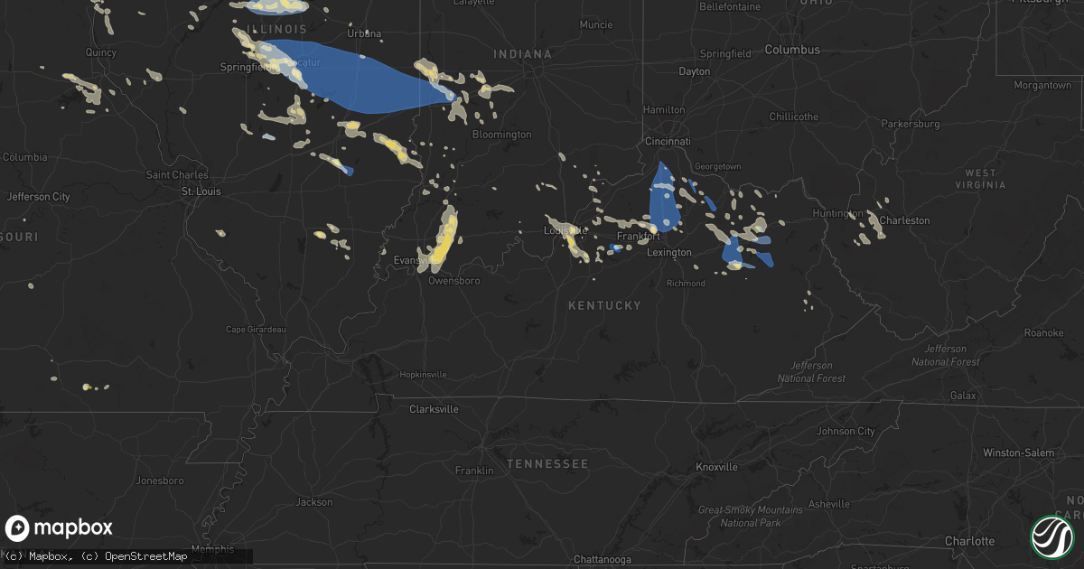
Hail Map in Kentucky on August 25, 2023
Get this storm
August 25 map
$229
one time, instant access
Download today. No call, no setup
Keep the $229
Bought the map and want the full workflow? Apply the entire $229 to a subscription within 7 days. None of it is wasted.
Every map, not just this one
This buys you this map. Subscription and you get every map we run, in the markets you choose from a few cities to whole states to nationwide. Plus real-time alerts the moment a storm fires.
Contact data
Name, contact info, occupancy, even credit band for addresses in the footprint. You go from where it hit to who to call.
Become the source they trust
Unlimited branding weather history reports on demand. You already have the documented answer ready for the property owner, and you are the one who showed up with it.
Property data and RoofTrace estimates
Pull up any address you have got, its value and the exact code rules for that jurisdiction, straight from One Click Code. Then RoofTrace estimates the squares, pitch, and roof value, priced the way you price.
Storm reports in Kentucky
Kentucky
| Date | Description |
|---|---|
| 08/25/20236:49 PM CDT | Delayed report of large tree down on brashears creek rd. |
| 08/25/20236:45 PM CDT | Delayed report. 2 large trees heavily damaged near taylorsville rd. |
| 08/25/20236:13 PM CDT | Delayed report of tree down on ashby rd. |
| 08/25/20236:10 PM CDT | Delayed report of tree down on johnson rd. |
| 08/25/20236:06 PM CDT | Delayed report of tree down on pisgah pike. |
| 08/25/20235:40 PM CDT | Ky mesonet site wadd measured 83 mph wind gust. |
| 08/25/20235:25 PM CDT | Delayed report of trees down on midway rd. |
| 08/25/20235:25 PM CDT | Multiple reports of power lines down in lexington. |
| 08/25/20235:25 PM CDT | Large tree down on crawley lane. |
| 08/25/20235:05 PM CDT | Multiple reports of trees down across georgetown and scott county. Power outages also reported across the county. Time estimated from radar. |
| 08/25/20234:55 PM CDT | Delayed report of tree down on johnson rd. |
| 08/25/20234:44 PM CDT | Delayed report. Report from mping of 1-inch tree limbs broken; shingles blown off. |
| 08/25/20234:30 PM CDT | Tree down on fork lick road. Time estimated from radar. |
| 08/25/20234:02 PM CDT | Delayed report of tree down on concord rd. |
| 08/25/20233:58 PM CDT | Trees down on claxton ridge road. Time estimated from radar. |
| 08/25/20233:58 PM CDT | Tree down on clarks creek road. Time estimated from radar. |
| 08/25/20233:54 PM CDT | Corrects previous tstm wnd dmg report from 5 wsw union. Tree down on big bone church road. Time estimated from radar. |
| 08/25/20233:43 PM CDT | Tree down on camp ernst road. Time estimated from radar. |
| 08/25/20233:26 PM CDT | Corrects previous tstm wnd dmg report from 5 sse falmouth. Corrects previous tstm wnd dmg report from 4 s falmouth. Numerous trees down reported south of falmouth. Time |
| 08/25/20233:26 PM CDT | Corrects previous tstm wnd dmg report from 4 s falmouth. Numerous trees down reported south of falmouth. Time estimated from radar. |
| 08/25/20233:26 PM CDT | Numerous trees down reported south of falmouth. Time estimated from radar. |
| 08/25/20233:09 PM CDT | Tree down on 165 off of 19. Time estimated from radar. |
| 08/25/20233:00 PM CDT | Tree reported down along route 650 about 2 miles from route 172. |
| 08/25/20231:06 PM CDT | Menifee county dispatch reported a tree down near the 90 block of indian creek rd. Time estimated from radar. |
| 08/25/202312:55 PM CDT | Menifee county dispatch reported a tree down near the 1400 block of tom stamper rd. Time estimated from radar. |
| 08/25/20232:25 AM CDT | Several trees and powerlines down in eastern henderson county. |
| 08/25/20232:25 AM CDT | Several trees and powe |
| 08/25/20232:25 AM CDT | Several trees and powerlines down in e |
| 08/24/20238:02 PM CDT | Delayed report of power lines down near north preston highway. |
| 08/24/20237:53 PM CDT | Delayed report... Two trees down on cooper chapel rd at beulah church rd. Time estimated from radar. |
| 08/24/20237:19 PM CDT | Reported at klou. |
| 08/24/20237:19 PM CDT | About 30 trees lost at oxmoor country club. Winds estimated around 65 mph. |
| 08/24/20237:12 PM CDT | Multiple trees and power lines down in the county. |
| 08/24/20237:00 PM CDT | Multiple large trees down on arlington court. Reported by private sector meteorologist. |
All States Impacted by Hail Map on August 25, 2023
Cities Impacted by Hail Map on August 25, 2023
- Moriarty, NM
- Encino, NM
- Frenchburg, KY
- Wellington, KY
- Denniston, KY
- Ezel, KY
- Morehead, KY
- Branchland, WV
- Hurricane, WV
- Winfield, WV
- Scott Depot, WV
- Hamlin, WV
- West Hamlin, WV
- Red House, WV
- Ranger, WV
- Midkiff, WV
- Spurlockville, WV
- Alkol, WV
- Means, KY
- Drift, KY
- Printer, KY
- Culloden, WV
- Griffithsville, WV
- Yawkey, WV
- Sumerco, WV
- Sod, WV
- Barboursville, WV
- Huntington, WV
- Salt Rock, WV
- Blue River, KY
- Prestonsburg, KY
- Martin, KY
- Langley, KY
- Clearfield, KY
- Olive Hill, KY
- Sandy Hook, KY
- Birch Tree, MO
- Alton, MO
- West Liberty, KY
- Goodman, MS
- Sallis, MS
- Pickens, MS
- Owingsville, KY
- Hillsboro, IL
- Irving, IL
- Fillmore, IL
- Coffeen, IL
- South Webster, OH
- Minford, OH
- Portsmouth, OH
- Palisade, NE
- Stratton, NE
- Falmouth, KY
- Foster, KY
- Brooksville, KY
- Mount Olivet, KY
- Germantown, KY
- Ewing, KY
- Mayslick, KY
- Skandia, MI
- Trenary, MI
- Shingleton, MI
- Munising, MI
- Au Train, MI
- Wetmore, MI
- Iron Mountain, MI
- Foster City, MI
- Rapid River, MI
- Hermansville, MI
- Perronville, MI
- Newberry, MI
- Manistique, MI
- Paradise, MI
- Eckerman, MI
- Seney, MI
- McMillan, MI
- Grand Marais, MI
- Bark River, MI
- Spalding, MI
- Wilson, MI
- Powers, MI
- Escanaba, MI
- Kinross, MI
- Hulbert, MI
- Germfask, MI
- Walton, KY
- Morning View, KY
- Independence, KY
- Hillsboro, KY
- De Mossville, KY
- Butler, KY
- Dry Ridge, KY
- Crittenden, KY
- Jonesville, KY
- Williamstown, KY
- Berry, KY
- Verona, KY
- Jeffersonville, KY
- Mount Sterling, KY
- Hope, KY
- Salt Lick, KY
- Olympia, KY
- Stockville, NE
- Curtis, NE
- Moorefield, NE
- Corinth, KY
- Brimley, MI
- Carney, MI
- Eustis, NE
- Mountainburg, AR
- Alma, AR
- Sadieville, KY
- Owenton, KY
- Georgetown, KY
- Stamping Ground, KY
- Cynthiana, KY
- Rudy, AR
- Mason, IL
- Edgewood, IL
- Louisville, IL
- Clay City, IL
- Ingraham, IL
- Herndon, KS
- Oberlin, KS
- Norton, KS
- Norcatur, KS
- Superior, NE
- Nelson, NE
- Phillipsburg, KS
- Prairie View, KS
- Almena, KS
- Clayton, KS
- Jennings, KS
- Wilsonville, NE
- Shelbyville, KY
- Waddy, KY
- Mount Eden, KY
- Plainville, KS
- Stockton, KS
- Hendley, NE
- Beaver City, NE
- Lenora, KS
- Maysville, KY
- Flemingsburg, KY
- Vanceburg, KY
- Saint Elmo, IL
- Brownstown, IL
- Scotia, NE
- Bagdad, KY
- Carlisle, KY
- Carthage, MS
- Manchester, OH
- Red Bud, IL
- Elnora, IN
- Myra, WV
- Billingsley, AL
- Paris, KY
- McCook, NE
- Stanton, KY
- Enterprise, LA
- Columbia, LA
- Harrisonburg, LA
- Jackson, OH
- Lawrence, NE
- Florien, LA
- Robeline, LA
- Provencal, LA
- Trenton, NE
- Stockton, MO
- Denton, GA
- Hazlehurst, GA
- Bedford, KY
- Hanover, IN
- Milton, KY
- Versailles, KY
- Frankfort, KY
- Wallingford, KY
- Danbury, NE
- Atwood, KS
- Ludell, KS
- Lebanon, MO
- Oxford, NE
- Orleans, NE
- Many, LA
- McDonald, KS
- Hemphill, TX
- Brandon, MS
- Lena, MS
- Morton, MS
- Smithfield, KY
- La Grange, KY
- Pendleton, KY
- Fort Necessity, LA
- Winnsboro, LA
- Culbertson, NE
- Eminence, KY
- Searcy, AR
- Judsonia, AR
- Pleasureville, KY
- Waynesville, MO
- Laquey, MO
- Oaktown, IN
- Clay City, KY
- Brookeland, TX
- Delhi, LA
- Chester, AR
- Oak Hill, OH
- Sharpsburg, KY
- Zwolle, LA
- Tullos, LA
- Commiskey, IN
- Deputy, IN
- Marion, AL
- Long Island, KS
- Walsenburg, CO
- Wilber, NE
- Tollesboro, KY
- Jesup, GA
- Hayes Center, NE
- Lexington, KY
- Ashland, LA
- Tallulah, LA
- North Vernon, IN
- Seymour, IN
- Duncanville, AL
- Tuscaloosa, AL
- Broxton, GA
- Edwards, MO
- Willow Springs, MO
- Madison, IN
- Beecher City, IL
- Moorefield, KY
- Sondheimer, LA
- Winchester, KY
- Lumber City, GA
- Fisher, LA
- Baxley, GA
- North Loup, NE
- Hermitage, MO
- Pomona, MO
- West Plains, MO
- Ambrose, GA
- Finchville, KY
- Louise, MS
- Marion Junction, AL
- La Crosse, KS
- Rush Center, KS
- Shawano, WI
- Stamford, NE
- Kensington, KS
- Republican City, NE
- Smith Center, KS
- Alma, NE
- Agra, KS
- Athol, KS
- Delavan, IL
- Hartsburg, IL
- Green Valley, IL
- Emden, IL
- San Jose, IL
- Hopedale, IL
- McLean, IL
- Atlanta, IL
- Stanford, IL
- Tremont, IL
- Shirley, IL
- Armington, IL
- Minier, IL
- Bloomington, IL
- Heyworth, IL
- Downs, IL
- Elkhart, IL
- Mount Pulaski, IL
- Lincoln, IL
- Williamsville, IL
- Kenney, IL
- Buffalo, IL
- Latham, IL
- Maroa, IL
- Warrensburg, IL
- Chestnut, IL
- Oreana, IL
- Argenta, IL
- Cisco, IL
- Niantic, IL
- Decatur, IL
- Macon, IL
- Harristown, IL
- Mt Zion, IL
- Forsyth, IL
- Boody, IL
- Mount Auburn, IL
- Illiopolis, IL
- Moweaqua, IL
- Blue Mound, IL
- Gorham, KS
- Russell, KS
- Monticello, IL
- Dalton City, IL
- Cerro Gordo, IL
- Bement, IL
- La Place, IL
- Ivesdale, IL
- Milmine, IL
- Lovington, IL
- Hammond, IL
- Villa Grove, IL
- Atwood, IL
- Sadorus, IL
- Pesotum, IL
- Tuscola, IL
- Arthur, IL
- Mattoon, IL
- Findlay, IL
- Charleston, IL
- Arcola, IL
- Gays, IL
- Trilla, IL
- Sullivan, IL
- Hindsboro, IL
- Bethany, IL
- Humboldt, IL
- Camargo, IL
- Windsor, IL
- Lerna, IL
- Redmon, IL
- Longview, IL
- Oakland, IL
- Kansas, IL
- Metcalf, IL
- Newman, IL
- Ashmore, IL
- Paris, IL
- Brocton, IL
- Clinton, IN
- Westfield, IL
- Chrisman, IL
- Murdock, IL
- Hume, IL
- Greenup, IL
- Marshall, IL
- Vermilion, IL
- Dennison, IL
- Martinsville, IL
- West Terre Haute, IN
- Casey, IL
- Washington, IN
- Morland, KS
- Lawrenceburg, KY
- Leavenworth, IN
- Wakeeney, KS
- Kyles Ford, TN
- Sneedville, TN
- Greencastle, IN
- Tylertown, MS
- Kokomo, MS
- Foxworth, MS
- Spearville, KS
- McCracken, KS
- Hays, KS
- Bardstown, KY
- Woodville, MS
- Orrville, AL
- Masonic Home, KY
- Louisville, KY
- Fillmore, IN
- Coatesville, IN
- Bainbridge, IN
- Oconto, WI
- Little Suamico, WI
- Abrams, WI
- New Franken, WI
- Mechanicsburg, IL
- Hillsdale, IN
- Rockville, IN
- Mecca, IN
- Montezuma, IN
- Hill City, KS
- Hanover, KS
- Gresham, WI
- Brazil, IN
- Carbon, IN
- Hermanville, MS
- Hazlehurst, MS
- Taylorsville, KY
- Utica, MS
- Pattison, MS
- Jackson, AL
- Athens, IL
- Rolling Fork, MS
- Hueysville, KY
- Luxemburg, WI
- Bicknell, IN
- Sylvan Grove, KS
- Dorrance, KS
- Easton, IL
- Valdosta, GA
- Quitman, GA
- Greenview, IL
- Clinton, LA
- Syracuse, KS
- Rosedale, IN
- Lucas, KS
- Casco, WI
- Kewaunee, WI
- Republic, KS
- Belleville, KS
- Garrison, KY
- Springfield, CO
- Uniontown, AL
- Newbern, AL
- Keokuk, IA
- Stilesville, IN
- New Holland, IL
- Catharine, KS
- Astoria, IL
- Collyer, KS
- Simpsonville, KY
- Mason City, IL
- Dawson, IL
- Middletown, IL
- Crestwood, KY
- Florence, MS
- Bison, KS
- Pritchett, CO
- Forest City, IL
- Topeka, IL
- Manito, IL
- Coxs Creek, KY
- Mount Washington, KY
- Willacoochee, GA
- Bloomfield, KY
- Garrett, KY
- Shepherdsville, KY
- Mayersville, MS
- Ipava, IL
- Lewistown, IL
- Salem, IN
- Scottsburg, IN
- Decatur, MS
- Conehatta, MS
- Mahomet, IL
- Champaign, IL
- Bridgeton, IN
- Dana, IN
- Utica, KS
- Fairdale, KY
- Concordia, KS
- Flat Rock, IL
- Urbana, IL
- Le Roy, IL
- Arrowsmith, IL
- Midway, KY
- Walnut Grove, MS
- Forest, MS
- Lake, MS
- Campton, KY
- Pearl, MS
- Richland, MS
- Green Bay, WI
- Washington, KS
- Browning, IL
- Wiggins, MS
- Trinidad, CO
- Bude, MS
- Meadville, MS
- Hamilton, IL
- Alexandria, MO
- Warsaw, IL
- Springfield, IL
- Clarksville, IN
- Jeffersonville, IN
- Glenview, KY
- Brooks, KY
- Borden, IN
- Floyds Knobs, IN
- Greenville, IN
- Georgetown, IN
- New Albany, IN
- Hebron, NE
- Chester, NE
- Hubbell, NE
- Gilead, NE
- Fairbury, NE
- Diller, NE
- Beatrice, NE
- Reynolds, NE
- Jansen, NE
- Wymore, NE
- Steele City, NE
- Endicott, NE
- Odell, NE
- Blue Springs, NE
- Bremen, KS
- Marysville, KS
- Hollenberg, KS
- Morrowville, KS
- Mahaska, KS
- Narka, KS
- Haddam, KS
- Knightsville, IN
- Staunton, IN
- New Goshen, IN
- Terre Haute, IN
- Universal, IN
- Wathena, KS
- Saint Joseph, MO
- Elwood, KS
- Sullivan, IN
- Pana, IL
- Plymouth, IL
- Homer, IL
- Litchfield, IL
- Robinson, IL
- Monroe City, MO
- Linton, IN
- West Point, IL
- Loraine, IL
- Mendon, IL
- Sutter, IL
- Assumption, IL
- Reelsville, IN
- Poland, IN
- Centerpoint, IN
- Carrollton, IL
- White Hall, IL
- Harvel, IL
- Morrisonville, IL
- Hidalgo, IL
- Willow Hill, IL
- Yale, IL
- Stoy, IL
- Annapolis, IL
- Palestine, IL
- Oblong, IL
- Sherman, IL
- Dahlgren, IL
- Belle Rive, IL
- Toledo, IL
- Teutopolis, IL
- Neoga, IL
- Sigel, IL
- Montrose, IL
- Jewett, IL
- Enfield, IL
- McLeansboro, IL
- Lakewood, IL
- Tower Hill, IL
- Taylorville, IL
- Wheatland, IN
- New Harmony, IN
- Mount Vernon, IN
- Spencer, IN
- Velpen, IN
- Esko, MN
- Cloquet, MN
- Boonville, IN
- West Baden Springs, IN
- Springerton, IL
- Switz City, IN
- Lyons, IN
- Oconee, IL
- Cowden, IL
- Cloverdale, IN
- Broughton, IL
- Stendal, IN
- Winslow, IN
- Petersburg, IN
- Otwell, IN
- Newburgh, IN
- Lynnville, IN
- Tennyson, IN
- Oakland City, IN
- Huntingburg, IN
- Wayne City, IL
- Hutsonville, IL
- Shelbyville, IL
- Hunnewell, MO
- Milltown, IN
- Owensboro, KY
- Reed, KY
- Gentryville, IN
- Dale, IN
- Farmer City, IL
- Clayton, IN
- Martinsville, IN
- Monrovia, IN
- Mooresville, IN
- Bowling Green, IN
- Cory, IN
- Clay City, IN
- Coal City, IN
- Freedom, IN
- New London, MO
- Frankford, MO
- Humboldt, NE
- Gosport, IN
- Paragon, IN
- Quincy, IN
- Riverton, IL
- Holly, CO
- Evansville, IN
- Spurgeon, IN
- Henderson, KY
- Spottsville, KY
- Chandler, IN
- Richland, IN
- Elberfeld, IN
- Baylis, IL
- Griggsville, IL
- Vincennes, IN
- Stewardson, IL
- Effingham, IL
- Dieterich, IL
- Ellettsville, IN
- Odon, IN
- Cantrall, IL
- Easton, MO
- Henley, MO
- Curryville, MO
- Shelbyville, MO
- Barry, IL
- New Canton, IL
- Butler, IL
- Hannibal, MO
- New Salem, IL
- Pittsfield, IL
- Nokomis, IL
- Center, MO
- Rosamond, IL
- Vandalia, MO
- Montgomery, IN
- Farina, IL
- Jasper, IN
- Santa Fe, MO


