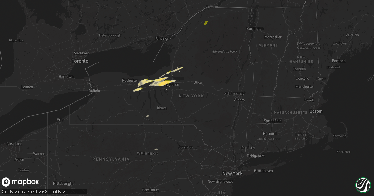
Hail Map in New York on August 24, 2025
Get this storm
August 24 map
$229
one time, instant access
Download today. No call, no setup
Keep the $229
Bought the map and want the full workflow? Apply the entire $229 to a subscription within 7 days. None of it is wasted.
Every map, not just this one
This buys you this map. Subscription and you get every map we run, in the markets you choose from a few cities to whole states to nationwide. Plus real-time alerts the moment a storm fires.
Contact data
Name, contact info, occupancy, even credit band for addresses in the footprint. You go from where it hit to who to call.
Become the source they trust
Unlimited branding weather history reports on demand. You already have the documented answer ready for the property owner, and you are the one who showed up with it.
Property data and RoofTrace estimates
Pull up any address you have got, its value and the exact code rules for that jurisdiction, straight from One Click Code. Then RoofTrace estimates the squares, pitch, and roof value, priced the way you price.
Storm reports in New York
New York
| Date | Description |
|---|---|
| 08/24/20254:30 PM CDT | County dispatch fielded a few calls about trees and wires down in town of tully. Radar-estimated time. |
| 08/24/20254:25 PM CDT | Tree and power lines down on highway 11b. |
| 08/24/20254:18 PM CDT | Multiple trees down on west parishville road. |
| 08/24/20254:16 PM CDT | Power lines down with tree on house on church st. |
| 08/24/20254:16 PM CDT | Tree and power lines down on pumpkin hill road. |
| 08/24/20254:11 PM CDT | Tree down blocking butternut ridge rd. |
| 08/24/20253:13 PM CDT | County dispatch fielded multiple calls of trees and wires down in the cicero area... Especially to southeast. Radar-estimated time. |
| 08/24/20253:01 PM CDT | Picture on social media |
| 08/24/20253:01 PM CDT | Picture on social media of a tree down on a house. |
| 08/24/20253:01 PM CDT | Photo on social med |
| 08/24/20253:01 PM CDT | Photo on social media of quarter-sized hail in salina/liverpool. |
| 08/24/20252:56 PM CDT | A local report indicates 1.00 inch wind near 1 N Lakeland |
| 08/24/20252:56 PM CDT | Report from social media. |
| 08/24/20252:54 PM CDT | *** 1 inj *** update to previous tstm wnd dmg report. Large tent collapsed outside of gate 4 of the great new york state fair and brought down a utility wire onto state |
| 08/24/20252:54 PM CDT | A tent collapsed outside of gate 4 of the great new york state fair and brought down a utility wire onto sate fair boulevard. An awning of another stand was damaged as |
| 08/24/20252:50 PM CDT | Tree down on wires. |
| 08/24/20252:46 PM CDT | Hail size estimated from picture. |
| 08/24/20252:46 PM CDT | Picture on social media of several quarter to half dollar sized hail stones along with a quarter for comparison. |
| 08/24/20252:40 PM CDT | Tree down on wires. |
| 08/24/20252:37 PM CDT | Photos of large tree branches down heading toward jordan via social media. |
| 08/24/20252:34 PM CDT | Tree down on wires. |
| 08/24/20252:33 PM CDT | A local report indicates 1.00 inch wind near Jordan |
| 08/24/20252:33 PM CDT | Report on social media of golf ball sized hail near lysander. |
| 08/24/20252:33 PM CDT | Trees and wires down. |
| 08/24/20252:32 PM CDT | Several barns damaged and one destroyed along river road. A few trees on houses and cars. Siding torn off of one house... Garage damage for another. Additional damage o |
| 08/24/20252:21 PM CDT | Several trees down in cato. Time estimated from radar. |
| 08/24/20252:17 PM CDT | Several trees down in weedsport. Time estimated from radar. |
| 08/24/20252:10 PM CDT | Several trees down in port byron. Time estimated from radar. |
| 08/24/20251:57 PM CDT | Reports of multiple trees down in savannah. Time estimated from radar. |
| 08/24/20251:52 PM CDT | Trees down in sodus. Time estimated from radar. |
| 08/24/20251:35 PM CDT | Multiple trees down in the town of acadia. Time estimated from radar. |
| 08/24/20251:35 PM CDT | Multiple calls taken by county dispatch for trees and wires down north and west of baldwinsville. Radar-estimated time. |
| 08/24/20251:15 PM CDT | Tree fell into roadway. |
| 08/24/20251:11 PM CDT | Estimated hail size from picture. Time estimated from radar. |
| 08/24/20251:09 PM CDT | Report of 2 trees down in the town of ira. Time estimated from radar. |
| 08/24/20251:09 PM CDT | Tree down partially blocking oakmount road. |
| 08/24/20251:08 PM CDT | Tree down blocking half of the road. |
| 08/24/20251:04 PM CDT | Report of half of a tree and wires down across state route 444. |
| 08/24/202512:38 PM CDT | Report of 2 trees down in palermo. Time estimated from radar. |
All States Impacted by Hail Map on August 24, 2025
Cities Impacted by Hail Map on August 24, 2025
- North Platte, NE
- Imperial, NE
- Enders, NE
- Wauneta, NE
- La Crosse, KS
- Nekoma, KS
- Rush Center, KS
- Palisade, NE
- Larned, KS
- Miller, NE
- Sumner, NE
- Brule, NE
- Big Springs, NE
- Marion, NY
- Palmyra, NY
- Newark, NY
- Macedon, NY
- Walworth, NY
- Quinter, KS
- Venango, NE
- Sodus, NY
- Lyons, NY
- Clyde, NY
- North Rose, NY
- Savannah, NY
- Wolcott, NY
- Fulton, NY
- Phoenix, NY
- Central Square, NY
- Parish, NY
- Port Byron, NY
- Red Creek, NY
- Cato, NY
- Mexico, NY
- Bloomfield, NY
- Victor, NY
- Canandaigua, NY
- Farmington, NY
- Shortsville, NY
- Clifton Springs, NY
- Manchester, NY
- Weedsport, NY
- Williamstown, NY
- West Monroe, NY
- Altmar, NY
- Camden, NY
- Redfield, NY
- Hanston, KS
- Waterloo, NY
- Seneca Falls, NY
- Montezuma, NY
- Kinsley, KS
- Jordan, NY
- Elbridge, NY
- Spearville, KS
- Offerle, KS
- Auburn, NY
- Syracuse, NY
- Baldwinsville, NY
- Warners, NY
- Memphis, NY
- Camillus, NY
- Escalante, UT
- Bucklin, KS
- Liverpool, NY
- Greensburg, KS
- Arriba, CO
- Clay, NY
- Flagler, CO
- Cicero, NY
- East Syracuse, NY
- Hannibal, NY
- Hastings, NY
- Colorado Springs, CO
- Pennellville, NY
- Bridgeport, NY
- Cripple Creek, CO
- Martville, NY
- Skaneateles, NY
- Fountain, CO
- Hugo, CO
- Canton, NY
- Potsdam, NY
- Colton, NY
- Pueblo, CO
- Kit Carson, CO
- Kirkland, AZ
- Corning, NY
- Karval, CO
- Beaver Dams, NY
- Horseheads, NY
- Thermal, CA
- Lipscomb, TX
- Higgins, TX
- Canadian, TX
- Rush, CO
- Reydon, OK
- Simla, CO
- Eads, CO
- Vici, OK
- Walsenburg, CO
- Erin, NY
- Sharon, OK
- Arnett, OK
- Ordway, CO
- Briscoe, TX
- Woodward, OK
- Mutual, OK
- Leedey, OK
- Camargo, OK
- Taloga, OK
- Ramah, CO
- Haswell, CO
- Sweetwater, OK
- Butler, OK
- Custer City, OK
- Wheeler, TX
- Sugar City, CO
- Calhan, CO
- Agate, CO
- Durham, OK
- Clinton, OK
- Grantsville, WV
- Big Bend, WV
- Pinon, AZ
- Elkland, PA
- Arapaho, OK
- Shamrock, TX
- Pampa, TX
- Marietta, NY
- Limon, CO
- Bosler, WY
- Foss, OK
- Cordell, OK
- Dill City, OK
- Canute, OK
- Laramie, WY
- Big Springs, WV
- Mobeetie, TX
- Lowman, NY
- Flemington, WV
- Bridgeport, WV
- Genoa, CO
- Dugway, UT
- Wendover, UT
- Woodrow, CO
- Clarendon, TX
- Anton, CO
- Lindon, CO
- Haviland, KS
- Wilmore, KS
- Mullinville, KS
- Muncy Valley, PA
- Hughesville, PA
- Williamsport, PA
- Akron, CO
- Cope, CO
- Yuma, CO
- Addison, NY
- Huntingdon, PA
- Petersburg, PA
- Paw Paw, WV
- Marcellus, NY
- Matheson, CO
- Holyoke, CO
- Sells, AZ
- Grant, NE


