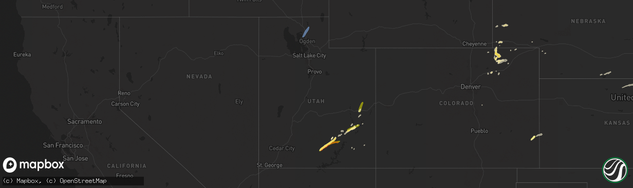
Hail Map in Utah on August 23, 2024
The weather event in Utah on August 23, 2024 includes Hail and Wind maps. 12 states and 304 cities were impacted and suffered possible damage. The total estimated number of properties impacted is 179.
Want more than just the map?
Turn this storm into a full workflow.
- Owner + property data so you know who to knock
- OnDemand branded weather history reports to win the "did we even have hail?" argument
- RoofTrace estimate so reps stop guessing numbers at the door
Bought this map? Upgrade within 7 days and we'll credit the $230. (10-15 min setup call)
Hail
Wind
179
Estimated number of impacted properties by a 1.00" hail or larger24
Estimated number of impacted properties by a 1.75" hail or larger0
Estimated number of impacted properties by a 2.50" hail or largerStorm reports in Utah
Utah
| Date | Description |
|---|---|
| 08/23/20245:43 PM CDT | A local report indicates 1.25 inch wind near Thompson Springs |
| 08/23/20245:00 PM CDT | Mesonet station psrim peter sinks rim. |
| 08/23/20244:50 PM CDT | Reported at logan-cache airport. |
| 08/23/20244:50 PM CDT | Mesonet station pc124 crow mountain. |
| 08/23/20244:42 PM CDT | 6 inch estimated limbs down in smithfield. |
| 08/23/20244:30 PM CDT | Mesonet station utwld i-15 at willard poe. |
| 08/23/20243:55 PM CDT | American fork marina mesonet site. |
All States Impacted by Hail Map on August 23, 2024
Cities Impacted by Hail Map on August 23, 2024
- Augusta, KS
- Andover, KS
- Rose Hill, KS
- Douglass, KS
- Culbertson, MT
- Fairview, MT
- Leon, KS
- Bainville, MT
- Saint David, AZ
- Mackay, ID
- Leadore, ID
- Lima, MT
- Menan, ID
- Palestine, TX
- Dubois, ID
- Oakwood, TX
- Ganado, AZ
- Keams Canyon, AZ
- Florahome, FL
- Fairfield, TX
- Kanab, UT
- Buffalo, TX
- Blanding, UT
- Teague, TX
- Vail, AZ
- Chinle, AZ
- Escalante, UT
- Granada, CO
- Waelder, TX
- Jewett, TX
- Holly, CO
- Mexia, TX
- Groesbeck, TX
- Wortham, TX
- Richland, TX
- Streetman, TX
- Benson, AZ
- Marquez, TX
- Boulder, UT
- Thompson Falls, MT
- Plains, MT
- Animas, NM
- Coolidge, TX
- Spencer, ID
- Philipsburg, MT
- Stevensville, MT
- Clinton, MT
- Drummond, MT
- Florence, MT
- Missoula, MT
- Lolo, MT
- Huson, MT
- Alberton, MT
- Milltown, MT
- Frenchtown, MT
- Bonner, MT
- Dillon, MT
- Virginia City, MT
- Dawson, TX
- Giddings, TX
- Prairie Hill, TX
- Mart, TX
- Purdon, TX
- Abilene, TX
- Willard, UT
- Brigham City, UT
- Mantua, UT
- Hyrum, UT
- Logan, UT
- Wellsville, UT
- Arlee, MT
- Alder, MT
- Sheridan, MT
- McAllister, MT
- Harrisburg, NE
- Grover, CO
- Syracuse, KS
- Paige, TX
- Dixon, MT
- Clancy, MT
- Helena, MT
- Fort Harrison, MT
- Canyon Creek, MT
- Wolf Creek, MT
- Saint Ignatius, MT
- Ravalli, MT
- Charlo, MT
- Hubbard, TX
- Breckenridge, TX
- Hanksville, UT
- Marion, MT
- Libby, MT
- Smithville, TX
- Temple, TX
- Mount Calm, TX
- Axtell, TX
- Thompson, UT
- Oracle, AZ
- New Raymer, CO
- Cascade, MT
- Wiggins, CO
- Roggen, CO
- Tucson, AZ
- Troy, TX
- Moulton, TX
- Peridot, AZ
- Eloy, AZ
- Sun River, MT
- Fort Shaw, MT
- Simms, MT
- Fairfield, MT
- Clyde, TX
- Gering, NE
- Casa Grande, AZ
- Coolidge, AZ
- Lorena, TX
- Rosanky, TX
- Fort Morgan, CO
- Gonzales, TX
- Ronan, MT
- Hot Springs, MT
- Polson, MT
- Pablo, MT
- Pony, MT
- Silver Star, MT
- Cardwell, MT
- Norris, MT
- Bayard, NE
- Bushnell, NE
- Newcastle, TX
- Crawford, TX
- McGregor, TX
- Belton, TX
- Kimball, NE
- Lonepine, MT
- Big Arm, MT
- Rollins, MT
- Dayton, MT
- Lakeside, MT
- Kila, MT
- Proctor, MT
- Elmo, MT
- Great Falls, MT
- Ulm, MT
- Sand Coulee, MT
- Augusta, MT
- Power, MT
- Choteau, MT
- Vaughn, MT
- Black Eagle, MT
- Floweree, MT
- Stockett, MT
- Dutton, MT
- Carter, MT
- Highwood, MT
- Fort Benton, MT
- Shiner, TX
- Flatonia, TX
- Rexford, MT
- Mcgrew, NE
- Marana, AZ
- Jarrell, TX
- Ledger, MT
- Loma, MT
- Brady, MT
- Valier, MT
- Chester, MT
- Conrad, MT
- Pendroy, MT
- Bynum, MT
- Stoneham, CO
- Young, AZ
- Salado, TX
- Georgetown, TX
- Merino, CO
- Snyder, CO
- Baird, TX
- Stockdale, TX
- Mooreland, OK
- Monticello, UT
- Nashua, MT
- Kalispell, MT
- Killeen, TX
- Browning, MT
- Dupuyer, MT
- Heart Butte, MT
- Cut Bank, MT
- Babb, MT
- Ethridge, MT
- Shelby, MT
- Galata, MT
- Oilmont, MT
- Sunburst, MT
- Lothair, MT
- Kevin, MT
- Sweet Grass, MT
- Joplin, MT
- Big Sandy, MT
- Rudyard, MT
- Whitlash, MT
- Inverness, MT
- Johnson City, TX
- Round Mountain, TX
- Roosevelt, AZ
- Albany, TX
- Florence, AZ
- Florence, TX
- Winslow, AZ
- Cisco, TX
- Geraldine, MT
- Chinook, MT
- Box Elder, MT
- Havre, MT
- Lloyd, MT
- Kremlin, MT
- Gildford, MT
- Hingham, MT
- Hays, MT
- Harlem, MT
- Turner, MT
- Zurich, MT
- Loring, MT
- Dodson, MT
- Hogeland, MT
- Moab, UT
- Green Valley, AZ
- Chambers, AZ
- Ovalo, TX
- Whitefish, MT
- Strawn, TX
- Larslan, MT
- Columbia Falls, MT
- San Simon, AZ
- Padroni, CO
- Sterling, CO
- Burnet, TX
- Moran, TX
- Peetz, CO
- Bertram, TX
- Lometa, TX
- Spring Branch, TX
- Kendalia, TX
- Richland, MT
- Opheim, MT
- Mason, TX
- Lampasas, TX
- Bend, TX
- San Saba, TX
- Hinsdale, MT
- Tow, TX
- Bluffton, TX
- Chappell, NE
- Buchanan Dam, TX
- Eastland, TX
- Rising Star, TX
- Cherokee, TX
- Valley Spring, TX
- Caddo, TX
- Carbon, TX
- Graford, TX
- Glentana, MT
- Peerless, MT
- Pontotoc, TX
- Frazer, MT
- Art, TX
- Cross Plains, TX
- Coleman, TX
- Whitewater, MT
- Venango, NE
- Fort Peck, MT
- Saco, MT
- Grant, NE
- Brusett, MT
- Glasgow, MT
- Corsicana, TX
- Malta, MT
- Scobey, MT
- Peyton, CO
- Redstone, MT
- Orleans, NE
- Alma, NE
- Elgin, AZ
- Republican City, NE
- Naponee, NE
- Jamestown, KS
- Beloit, KS
- Concordia, KS
- Bloomington, NE
- Mankato, KS
- Esbon, KS
- Aurora, KS
- Formoso, KS
- Courtland, KS
- Clyde, KS
- Belleville, KS
- Scandia, KS
- Westmoreland, KS
- Amazonia, MO
- Leesville, TX
- Oregon, MO
- Savannah, MO
- Maysville, MO
- Kansas City, MO
- Albany, MO


