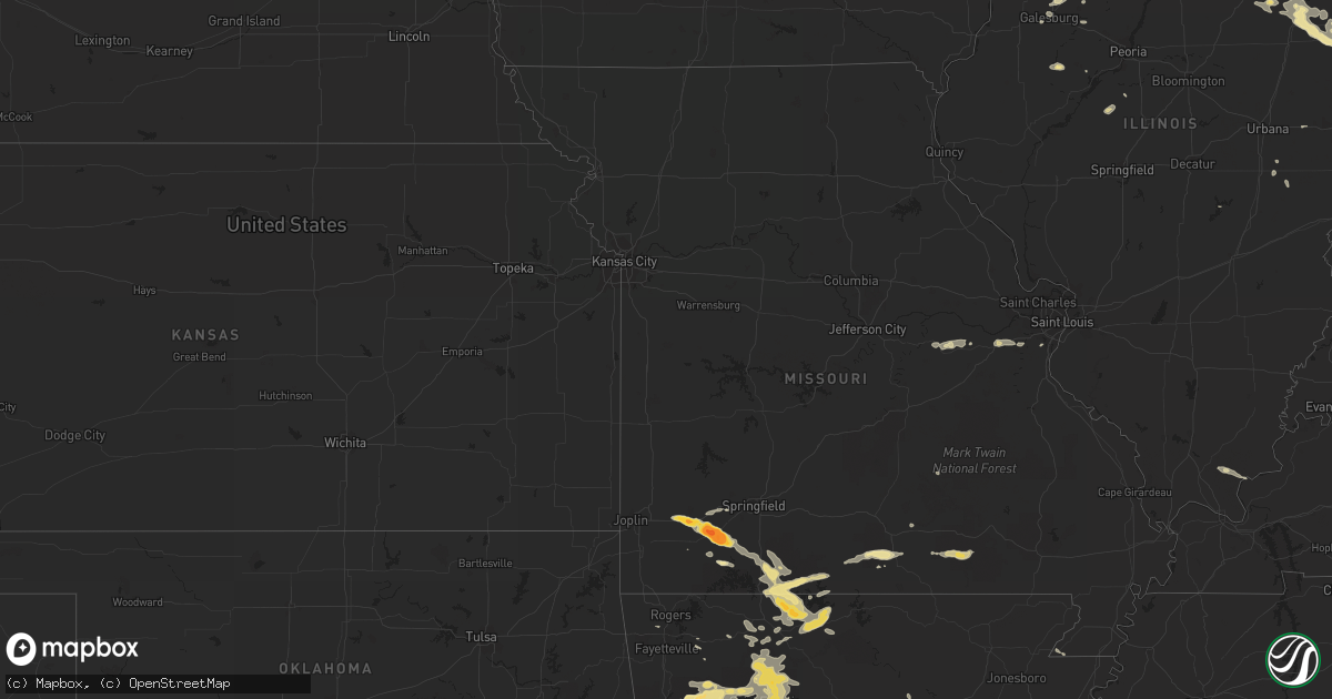
Hail Map in Illinois on August 20, 2011
Get this storm
August 20 map
$229
one time, instant access
Download today. No call, no setup
Keep the $229
Bought the map and want the full workflow? Apply the entire $229 to a subscription within 7 days. None of it is wasted.
Every map, not just this one
This buys you this map. Subscription and you get every map we run, in the markets you choose from a few cities to whole states to nationwide. Plus real-time alerts the moment a storm fires.
Contact data
Name, contact info, occupancy, even credit band for addresses in the footprint. You go from where it hit to who to call.
Become the source they trust
Unlimited branding weather history reports on demand. You already have the documented answer ready for the property owner, and you are the one who showed up with it.
Property data and RoofTrace estimates
Pull up any address you have got, its value and the exact code rules for that jurisdiction, straight from One Click Code. Then RoofTrace estimates the squares, pitch, and roof value, priced the way you price.
Storm reports in Illinois
Illinois
| Date | Description |
|---|---|
| 08/20/201110:40 AM CDT | Delayed report. Power lines downed...igniting a gas fire. |
| 08/20/201110:08 AM CDT | Numerous six to twelve inch tree branches downed in the area. |
| 08/20/201110:04 AM CDT | Delayed report.several trees and tree limbs down. |
| 08/20/20119:40 AM CDT | Delayed report. Burst of wind between 940 am and 942 am resulting in multiple large tree limbs down. |
| 08/20/20118:35 AM CDT | Cocorahs observer. |
| 08/20/20118:26 AM CDT | Trees down. Size unknown at this time. |
| 08/19/20118:10 PM CDT | Barn blown apart with debris in trees and power lines. 1 mile east of rt. 40 near camp grove road. Time estimated. |
All States Impacted by Hail Map on August 20, 2011
Cities Impacted by Hail Map on August 20, 2011
- Lake Providence, LA
- Peck, MI
- Melvin, MI
- Croswell, MI
- Yale, MI
- Gladwin, MI
- Muskegon, MI
- Lead Hill, AR
- Harrison, AR
- Yellville, AR
- Kissee Mills, MO
- Powersite, MO
- Rockaway Beach, MO
- Kirbyville, MO
- Cedarcreek, MO
- Forsyth, MO
- Branson, MO
- Cape Fair, MO
- Aurora, MO
- Rudy, AR
- Texarkana, AR
- Valentine, NE
- Wood Lake, NE
- Rossville, TN
- Story, AR
- Sims, AR
- Register, GA
- Statesboro, GA
- Brooklet, GA
- Sheldon, IL
- Saint Anne, IL
- Watseka, IL
- Chebanse, IL
- Earl Park, IN
- Ashkum, IL
- Kankakee, IL
- Clifton, IL
- Kentland, IN
- Martinton, IL
- Buckingham, IL
- Reddick, IL
- Northbrook, IL
- Winnetka, IL
- Atoka, TN
- Millington, TN
- Oak Grove, LA
- Orchard, CO
- Weldona, CO
- Deer, AR
- Clinton, SC
- Kinards, SC
- Morocco, IN
- Donovan, IL
- Brook, IN
- Saint Matthews, SC
- Manhattan, IL
- Isabella, MO
- Protem, MO
- Taneyville, MO
- Hollister, MO
- Rueter, MO
- Theodosia, MO
- Omaha, AR
- Peel, AR
- Thornfield, MO
- Walnut Shade, MO
- Glennie, MI
- Mikado, MI
- Cruger, MS
- Tchula, MS
- Spring Grove, IL
- Twin Lakes, WI
- Richmond, IL
- Genoa City, WI
- Howard City, MI
- Newaygo, MI
- Columbiaville, MI
- Clio, MI
- Otisville, MI
- Otter Lake, MI
- Mount Morris, MI
- Flushing, MI
- Crookston, NE
- Kilgore, NE
- Saint Francis, SD
- West Monroe, LA
- Mount Vernon, MO
- Verona, MO
- Crane, MO
- Marionville, MO
- Smackover, AR
- El Dorado, AR
- Galva, IL
- Kewanee, IL
- Altona, IL
- Simpson, IL
- Eddyville, IL
- Spearsville, LA
- Ainsworth, NE
- Johnstown, NE
- Grover, CO
- Carpenter, WY
- Pine Bluffs, WY
- Fort Morgan, CO
- Whitman, NE
- Merriman, NE
- Juda, WI
- Brodhead, WI
- Cotter, AR
- Flippin, AR
- Lakeview, AR
- Bull Shoals, AR
- Summit, AR
- West Plains, MO
- Pomona, MO
- Oark, AR
- Jasper, AR
- Parthenon, AR
- Dover, AR
- Saint Paul, AR
- Mount Judea, AR
- Ozone, AR
- Hector, AR
- Ozark, AR
- Vendor, AR
- Clarksville, AR
- Hagarville, AR
- Combs, AR
- Pelsor, AR
- Dora, MO
- Stoneham, CO
- Holly Springs, MS
- Bonfield, IL
- Birch Tree, MO
- Alton, MO
- Fremont, MO
- Harvey, AR
- Gravelly, AR
- Millington, MI
- Erie, PA
- Fleming, CO
- Mendota, IL
- Beaufort, MO
- Burns, WY
- Walworth, WI
- Sharon, WI
- South Beloit, IL
- Poplar Grove, IL
- Janesville, WI
- Beloit, WI
- Clinton, WI
- Darien, WI
- Capron, IL
- Harvard, IL
- Orfordville, WI
- Caledonia, IL
- Rockton, IL
- Roscoe, IL
- Machesney Park, IL
- Durand, IL
- Davis, IL
- Rockford, IL
- Transylvania, LA
- Tuthill, SD
- Farwell, MI
- Lake, MI
- Collierville, TN
- Wiggins, CO
- Martin, SC
- Clarksville, TN
- West Olive, MI
- Libertyville, IL
- Gurnee, IL
- Waukegan, IL
- Dyer, AR
- Mulberry, AR
- Alma, AR
- Booneville, AR
- Magazine, AR
- Ash, NC
- Eads, TN
- Wadsworth, IL
- Big Rapids, MI
- White Cloud, MI
- Parmelee, SD
- McKean, PA
- Waterford, PA
- Edinboro, PA
- Evart, MI
- Barryton, MI
- Hersey, MI
- Rodney, MI
- Chippewa Lake, MI
- Paris, MI
- Sears, MI
- Cheyenne, WY
- Golconda, IL
- Smithland, KY
- Isola, MS
- Inverness, MS
- Hollandale, MS
- Salley, SC
- North, SC
- Lupton, MI
- South Branch, MI
- Vaiden, MS
- West, MS
- Forsyth, GA
- Blackfoot, ID
- Easton, IL
- San Jose, IL
- Mason City, IL
- Norman, AR
- Mount Ida, AR
- Shirland, IL
- Pettigrew, AR
- Elkins, AR
- Mountainburg, AR
- Witts Springs, AR
- Lavaca, AR
- Charleston, AR
- Winslow, AR
- Hasty, AR
- Western Grove, AR
- Rose City, MI
- Floral, AR
- Grover, NC
- Kings Mountain, NC
- Salt Lake City, UT
- West Jordan, UT
- Morris, IL
- Coal City, IL
- Mazon, IL
- Canton, IL
- Ellisville, IL
- Smithfield, IL
- Cuba, IL
- Grand Haven, MI
- Rayville, LA
- Gordon, NE
- Harleyville, SC
- Bowman, SC
- Saint George, SC
- Spring Hill, FL
- Brooksville, FL
- Belmont, MI
- Rockford, MI
- Hale, MI
- Ashland City, TN
- Chapmansboro, TN
- Mantee, MS
- Mathiston, MS
- Twin Lake, MI
- Holton, MI
- Fremont, MI
- Ravenna, MI
- Grant, MI
- Toulon, IL
- Wataga, IL
- Oneida, IL
- Windsor, IL
- Campbell, OH
- Canfield, OH
- Youngstown, OH
- Hillsdale, WY
- Applegate, MI
- Lexington, MI
- Sumner, MI
- Island Lake, IL
- Mchenry, IL
- Crystal Lake, IL
- Homer, LA
- Randolph, MS
- Villa Grove, IL
- Wayan, ID
- Grenada, MS
- Purdy, MO
- Garrett, WY
- Lake Zurich, IL
- Delavan, WI
- Lake Geneva, WI
- Hebron, IL
- Wauconda, IL
- Cary, IL
- Barrington, IL
- Round Lake, IL
- Woodstock, IL
- Monroe, WI
- Wonder Lake, IL
- Fox River Grove, IL
- Mundelein, IL
- Palatine, IL
- Bolton, MS
- Flora, MS
- Canton, MS
- Bentonia, MS
- Whitmire, SC
- Pierce City, MO
- Stotts City, MO
- North Branch, MI
- Harleton, TX
- Spring Lake, MI
- Coleman, MI
- Solano, NM
- Conchas Dam, NM
- Mosquero, NM
- Cardwell, MO
- Cabery, IL
- Dwight, IL
- Herscher, IL
- Malta, ID
- McCarley, MS
- Winona, MS
- Glencoe, NM
- Alto, NM
- Atlanta, TX
- Sarcoxie, MO
- Wentworth, MO
- Thomaston, GA
- Molena, GA
- Meansville, GA
- Zebulon, GA
- Concord, GA
- Comstock Park, MI
- Delight, AR
- Antoine, AR
- Alma, MI
- Mission, SD
- Martin, SD
- Aiken, SC
- Windsor, SC
- Williston, SC
- Mona, UT
- Prescott, AR
- Blevins, AR
- Genesee, MI
- Fostoria, MI
- Flint, MI
- Merino, CO
- Arlington, TN
- Lecanto, FL
- Edwards, MS
- Norris, SD
- Lincolnwood, IL
- Skokie, IL
- Chicago, IL
- Evanston, IL
- South Wilmington, IL
- Essex, IL
- Gardner, IL
- Fithian, IL
- Convoy, OH
- Douglassville, TX
- Morley, MI
- Bartlett, IL
- Elgin, IL
- Streamwood, IL
- Schaumburg, IL
- Hoffman Estates, IL
- Lincoln, MI
- Harrisville, MI
- Pioneer, LA
- Brown City, MI
- Marlette, MI
- Platteville, CO
- La Fontaine, IN
- Vestaburg, MI
- Edmore, MI
- Galena, MO
- Freistatt, MO
- Everton, AR
- Reeds Spring, MO
- Monett, MO
- Gassville, AR
- Spokane, MO
- Billings, MO
- Mountain View, MO
- Wesley, AR
- Hindsville, AR
- Huntsville, AR
- Braidwood, IL
- Wilmington, IL
- Plum Branch, SC
- Edgefield, SC
- McCormick, SC
- Ridgeway, OH
- Magnolia, AR
- Springfield, GA
- Clyo, GA
- Gerald, MO
- Coffeeville, MS
- Springdale, AR
- Akron, CO
- Atwood, CO
- Sterling, CO
- Berryville, AR
- Stanton, MI
- Pacific, MO
- Villa Ridge, MO
- Gray Summit, MO
- Homosassa, FL
- Nashville, AR
- Inkom, ID
- Camargo, IL
- Tuscola, IL
- Pelion, SC
- Swansea, SC
- Republic, MO
- West Branch, MI
- Paris, AR
- East Tawas, MI
- Oakley, ID
- Lillie, LA
- Junction City, AR
- Bernice, LA
- Fairview, PA
- Rock Creek, OH
- Springer, NM
- Gladstone, NM
- Raymond, MS
- Bivins, TX
- Dundee, IL
- Algonquin, IL
- Union, IL
- Lake In The Hills, IL
- Huntley, IL
- Salters, SC
- Andrews, SC
- Branchville, SC
- Holcomb, MS
- Monee, IL
- Alamo, GA
- Girard, PA
- North East, PA
- Ripley, NY
- Bessemer, AL
- Middle River, MD
- White Marsh, MD
- Perry Hall, MD
- Duck Hill, MS
- Vardaman, MS
- Chiefland, FL
- Marshall, TX
- Newport, MI
- Lincolnton, GA
- Elwell, MI
- Crystal, MI
- Riverdale, MI
- Chesaning, MI
- Elsie, MI
- Saint Charles, MI
- Henderson, MI
- Oakley, MI
- Alpena, AR
- Green Forest, AR
- Marble Falls, AR
- Compton, AR
- Green Valley, IL
- Ridgeville, SC
- Midvale, UT
- Ruidoso, NM
- Sidon, MS
- Willow Springs, MO
- Heber Springs, AR
- Eastover, SC
- Oxford, MS
- Haynesville, LA
- Boles, AR
- Willoughby, OH
- Vernon Hills, IL
- Russell, PA
- Sugar Grove, PA
- Warren, PA
- Grand Rapids, MI
- Sparta, MI
- Gainesville, MO
- Brixey, MO
- Zanoni, MO
- Birch Run, MI
- Eureka, MO
- Iroquois, IL
- Papineau, IL
- Goodland, IN
- Beaverville, IL
- Steinhatchee, FL
- Bailey, MI
- Cordova, TN
- Coopersville, MI
- Conklin, MI
- Guyton, GA
- Wattsburg, PA
- Hampshire, IL
- Marengo, IL
- Gilberts, IL
- Rosebud, MO
- Niles, OH
- South Paris, ME
- Streator, IL
- Grand Ridge, IL
- Barnwell, SC
- Allendale, SC
- Oakland, MS
- Burt, MI
- Montrose, MI
- Nakina, NC
- Calhoun City, MS
- Eupora, MS
- Epps, LA
- Jessieville, AR
- Clare, MI
- Hope, MI
- Sanford, MI
- Arnold, MO
- Fenton, MO
- Bluffton, AR
- Danville, AR
- Waldron, AR
- Delhi, LA
- Winnsboro, LA
- Eudora, AR
- Larkspur, CO
- La Rue, OH
- Mount Victory, OH
- Richwood, OH
- Columbus, MS
- Utica, MS
- Arlington, IL
- Manning, SC
- Columbus, PA
- Panama, NY
- Bear Lake, PA
- Shepherd, MI
- Belle Center, OH
- Rushsylvania, OH
- Morriston, FL
- Hesperia, MI
- Hampden, ME
- Avoca, MI
- Jeddo, MI
- Byhalia, MS
- West Mansfield, OH
- Warren, OH
- Sheffield, IL
- Annawan, IL
- Barton City, MI
- Peotone, IL
- Lewisville, AR
- Houlka, MS
- Bruce, MS
- Minooka, IL
- Newark, IL
- Owensville, MO
- New Haven, MO
- Saint Helen, MI
- Locust Grove, AR
- Belzoni, MS
- Twin City, GA
- Oil Trough, AR
- Dahinda, IL
- Williamsfield, IL
- Land O'Lakes, FL
- New Raymer, CO
- Monroe, LA
- Pottersville, MO
- Ithaca, MI
- Ashley, MI
- Snover, MI
- Ubly, MI
- Carrollton, MS
- Adams, TN
- Nunica, MI
- Memphis, TN
- Chardon, OH
- Mentor, OH
- Stanwood, MI
- Oakland, IL
- Brocton, IL
- Waterford, MS
- West Chicago, IL
- Mansfield, AR
- Galesburg, IL
- Bois D Arc, MO
- Ash Grove, MO
- Kennesaw, GA
- Avon, IL
- Water Valley, MS
- Prudenville, MI
- Okolona, AR
- Kalamazoo, MI
- Portage, MI
- Arbyrd, MO
- Tampa, FL
- Odessa, FL
- Salem, MO
- Jadwin, MO
- Oakland, AR
- Pontiac, MO
- Bronson, FL
- Arlington Heights, IL
- Mount Prospect, IL
- Marion, OH
- McNabb, IL
- Magnolia, IL
- Gastonia, NC
- Bessemer City, NC
- Victoria, IL
- La Fayette, IL
- Idaville, IN
- Monticello, IN
- Davison, MI
- Imlay City, MI
- Rosedale, MD
- Nottingham, MD
- Essex, MD
- Pleasant View, TN
- Cedar Hill, TN
- Coloma, MI
- Joanna, SC
- Ringwood, IL
- Leslie, MO
- Bellefontaine, MS
- Southaven, MS
- Marne, MI
- Cameron, IL
- Columbus, GA
- Red Banks, MS
- Malden, IL
- Merrill, MI
- Hemlock, MI
- Stamps, AR
- Buckner, AR
- Lamar, AR
- Joelton, TN
- Lena, IL
- Gore Springs, MS
- Bradford, ME
- Hudson, ME


