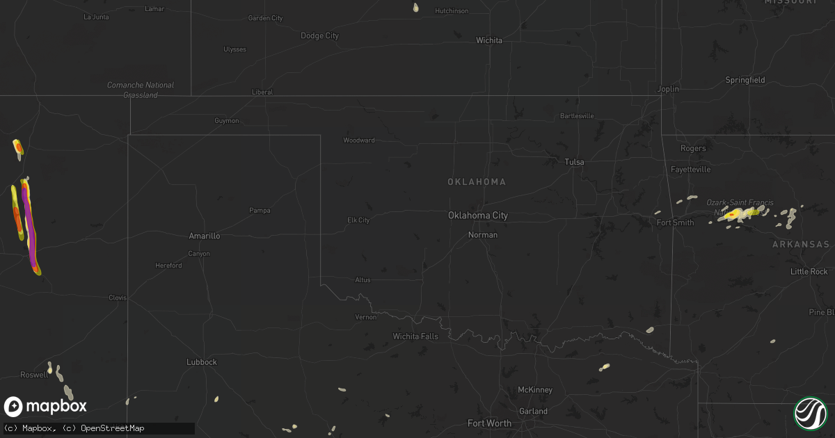
Hail Map in Oklahoma on August 19, 2018
Get this storm
August 19 map
$229
one time, instant access
Download today. No call, no setup
Keep the $229
Bought the map and want the full workflow? Apply the entire $229 to a subscription within 7 days. None of it is wasted.
Every map, not just this one
This buys you this map. Subscription and you get every map we run, in the markets you choose from a few cities to whole states to nationwide. Plus real-time alerts the moment a storm fires.
Contact data
Name, contact info, occupancy, even credit band for addresses in the footprint. You go from where it hit to who to call.
Become the source they trust
Unlimited branding weather history reports on demand. You already have the documented answer ready for the property owner, and you are the one who showed up with it.
Property data and RoofTrace estimates
Pull up any address you have got, its value and the exact code rules for that jurisdiction, straight from One Click Code. Then RoofTrace estimates the squares, pitch, and roof value, priced the way you price.
Storm reports in Oklahoma
Oklahoma
| Date | Description |
|---|---|
| 08/19/20184:01 PM CDT | Barns and outbuildings damaged along highway 69 near mazie. Likely tornado damage. Approximate location. |
| 08/19/20183:43 PM CDT | Spotter reported tornado southwest of mazie and causing damage. |
| 08/19/20183:40 PM CDT | Barn destroyed... Several other outbuildings damaged or destroyed. Lots of tree damage. Possible tornado. |
| 08/19/201812:16 AM CDT | At 515 PM CDT, severe thunderstorms were located along a line extending from near Liberal to near Carterville to near South West City, moving east at 35 mph. HAZARD...60 mph wind gusts and penny size hail. SOURCE...Radar indicated. IMPACT...Expect damage to roofs, siding, and trees. Locations impacted include... Joplin... Carthage... Neosho... Webb City... Prairie State Park... Big Sugar Creek State Park... Carl Junction... Lamar... Oronogo... Seneca... Granby... Anderson... Carterville... Noel... Duquesne... Dodge... Sarcoxie... Goodman... Duenweg... South West City...This includes the following highways... Interstate 44 between mile markers 4 and 32. Interstate 49 between mile markers 1 and 76. |
| 08/18/201811:22 PM CDT | At 422 PM CDT, severe thunderstorms were located along a line extending from near Arcadia to near Columbus to Miami, moving east at 40 mph. HAZARD...60 mph wind gusts and nickel size hail. SOURCE...Radar indicated. IMPACT...Expect damage to roofs, siding, and trees. Locations impacted include... Joplin... Pittsburg... Carthage... Neosho... Webb City... Prairie State Park... Carl Junction... Lamar... Baxter Springs... Frontenac... Columbus... Galena... Girard... Oronogo... Seneca... Granby... Carterville... Duquesne... Arma... Sarcoxie...This includes the following highways... Interstate 44 between mile markers 0 and 31. Interstate 49 between mile markers 22 and 76. |
| 08/18/201811:12 PM CDT | At 412 PM CDT, a severe thunderstorm was located 4 miles south of Brushy, moving northeast at 30 mph. HAZARD...60 mph wind gusts and quarter size hail. SOURCE...Radar indicated. IMPACT...Hail damage to vehicles is expected. Expect wind damage to roofs, siding, and trees. Locations in or near the path include... Brushy... Short...This includes Interstate 40 in Oklahoma between mile markers 312 and313. |
All States Impacted by Hail Map on August 19, 2018
Cities Impacted by Hail Map on August 19, 2018
- Trementina, NM
- Otis, KS
- Paris, TX
- Pattonville, TX
- Douglas, AZ
- Hudson, KS
- Cuervo, NM
- Lamar, AR
- Clarksville, AR
- Garita, NM
- Santa Rosa, NM
- Big Spring, TX
- Tahoka, TX
- Roby, TX
- Gladstone, NM
- Union Hall, VA
- Roswell, NM
- Miami, NM
- Springer, NM
- Norcatur, KS
- Monticello, AR
- Dover, AR
- Pelsor, AR
- Plant City, FL
- Sylvia, KS
- St John, KS
- Myakka City, FL
- Ona, FL
- Gretna, VA
- Cimarron, NM
- Hampden Sydney, VA
- Farmville, VA
- Bisbee, AZ
- Scotland, AR
- Cleveland, AR
- Gorham, KS
- Catharine, KS
- Plainville, KS
- Wagon Mound, NM
- Anson, TX
- Hawley, TX
- Java, VA
- Nogales, AZ
- Russell, KS
- Sallisaw, OK
- Hays, KS
- Denver City, TX
- London, AR
- Creedmoor, NC
- Plains, TX
- Kinder, LA
- Oberlin, LA
- Broken Bow, OK
- Hattieville, AR
- Olmitz, KS
- Great Bend, KS
- Twin Brooks, SD
- Crescent City, FL
- Pomona Park, FL
- Miltona, MN
- Parkers Prairie, MN
- Cedarville, AR
- Chester, AR
- Lakeland, FL
- Raleigh, NC
- Ellinwood, KS
- Las Vegas, NM
- Hartman, AR
- Hagarville, AR
- Ozark, AR
- Ratcliff, AR
- Kirkland, AZ
- Solgohachia, AR
- Springfield, AR
- Center Ridge, AR
- Clinton, AR
- Odessa, TX
- Victoria, KS
- Carlsbad, NM
- Hector, AR
- Ellis, KS
- Subiaco, AR
- Scranton, AR
- Halifax, VA
- Nathalie, VA
- Valmora, NM
- Polk City, FL
- Patagonia, AZ
- Breckenridge, TX
- Bartow, FL
- Cove City, NC
- Franklinton, NC
- Oxford, NC
- Stem, NC
- Butner, NC
- Slaughter, LA
- Ethel, LA
- Mountainburg, AR
- Holly Grove, AR
- Donaldsonville, LA
- Sweetwater, TX
- Jerusalem, AR
- Hagerman, NM
- Fort McCoy, FL
- Sorrento, LA
- Gonzales, LA
- Zephyrhills, FL
- Springfield, GA
- Clyo, GA
- Cooper, TX
- Lake Creek, TX
- Hoisington, KS
- Knoxville, AR
- Altus, AR
- Coal Hill, AR
- Minneota, MN
- Haskell, TX
- Zachary, LA
- Jackson, LA
- Parrish, FL
- New Blaine, AR
- Delaware, AR
- Sparkman, AR
- Nolan, TX
- Blackwell, TX
- Willard, NC
- Ivanhoe, NC
- Orlando, FL
- Mulberry, FL
- Shirley, AR


