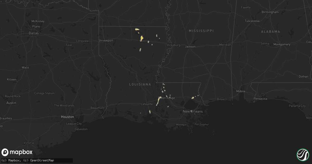
Hail Map in Louisiana on August 17, 2025
Get this storm
August 17 map
$229
one time, instant access
Download today. No call, no setup
Keep the $229
Bought the map and want the full workflow? Apply the entire $229 to a subscription within 7 days. None of it is wasted.
Every map, not just this one
This buys you this map. Subscription and you get every map we run, in the markets you choose from a few cities to whole states to nationwide. Plus real-time alerts the moment a storm fires.
Contact data
Name, contact info, occupancy, even credit band for addresses in the footprint. You go from where it hit to who to call.
Become the source they trust
Unlimited branding weather history reports on demand. You already have the documented answer ready for the property owner, and you are the one who showed up with it.
Property data and RoofTrace estimates
Pull up any address you have got, its value and the exact code rules for that jurisdiction, straight from One Click Code. Then RoofTrace estimates the squares, pitch, and roof value, priced the way you price.
Storm reports in Louisiana
Louisiana
| Date | Description |
|---|---|
| 08/17/20256:52 PM CDT | A tree and multiple large limbs were snapped behind and adjacent to a home in the northern sections of west monroe. Report from social media. |
| 08/17/20256:35 PM CDT | Trees down across highway 2 east at stewart road. |
| 08/17/20256:33 PM CDT | A tree top was snapped and fell across jimmy johnson road just north of highway 15. |
| 08/17/20256:20 PM CDT | A skirting was blown off of a mobile home in the conway community. Large tree limbs were snapped as well. Report via social media. |
| 08/16/20257:10 PM CDT | Public call of limbs up to 2 inches broken along with power outages in the woodridge neighborhood in mandeville. Time estimated by radar. |
| 08/16/20257:10 PM CDT | Public call of limbs up to 2 inches broken along with power outages in the woodridge neighborhood in mandeville. Time estimated by radar. |
All States Impacted by Hail Map on August 17, 2025
Cities Impacted by Hail Map on August 17, 2025
- Ipswich, SD
- Aberdeen, SD
- Columbia, SD
- Houghton, SD
- Claremont, SD
- Amherst, SD
- Andover, SD
- Langford, SD
- Mount Auburn, IL
- Conde, SD
- Webster, SD
- Roslyn, SD
- Eden, SD
- Britton, SD
- Pierpont, SD
- Mechanicsburg, IL
- Lake City, SD
- Grenville, SD
- Buffalo, IL
- Leola, SD
- Roscoe, SD
- Bath, SD
- Westport, SD
- Groton, SD
- Bristol, SD
- Waubay, SD
- Sisseton, SD
- Peever, SD
- Ellendale, ND
- Fullerton, ND
- Henley, MO
- Greensburg, PA
- Bovard, PA
- Jeannette, PA
- Latrobe, PA
- Bradenville, PA
- Youngstown, PA
- Derry, PA
- Hostetter, PA
- Ligonier, PA
- Loyalhanna, PA
- Pleasant Unity, PA
- Rector, PA
- Acme, PA
- Laughlintown, PA
- Stahlstown, PA
- Mount Pleasant, PA
- Hunker, PA
- Youngwood, PA
- Luxor, PA
- Bradford, AR
- Boswell, PA
- Somerset, PA
- Smithton, MO
- Fowler, IL
- Quincy, IL
- McRae, AR
- Holts Summit, MO
- Searcy, AR
- Rose Bud, AR
- Custer, SD
- New Bloomfield, MO
- Fulton, MO
- Hot Springs, SD
- Buffalo Gap, SD
- White Castle, LA
- Belfast, ME
- Gulfport, MS
- Mokane, MO
- Collinsville, AL
- Lubbock, TX
- Quitman, AR
- Long Beach, MS
- Carbon Hill, AL
- Linn, MO
- Hannibal, MO
- Pass Christian, MS
- Payson, IL
- Warren, AR
- Columbia, MO
- Hull, IL
- Bankston, AL
- Plainville, IL
- Center, MO
- Alton, MO
- Pequea, PA
- Winnsboro, LA
- Quarryville, PA
- Drumore, PA
- Holtwood, PA
- Sturkie, AR
- Viola, AR
- Salem, AR
- Greenwell Springs, LA
- Baton Rouge, LA
- Couch, MO
- Shallowater, TX
- New Providence, PA
- Nemo, SD
- Deadwood, SD
- Harrisburg, MO
- Lecanto, FL
- Piedmont, SD
- Abbeville, LA
- Mena, AR
- Peach Bottom, PA
- Clarendon, TX
- Slaughter, LA
- Centreville, AL
- Conowingo, MD
- Washington, MO
- Mobeetie, TX
- Sturgis, SD
- Zachary, LA
- Jackson, LA
- Miami, TX
- Bowling Green, MO
- Rolla, MO
- Rising Sun, MD
- Lynchburg, MO
- Quitaque, TX
- Vichy, MO
- Starkville, MS
- Winona, MS
- Duck Hill, MS
- Pioneer, LA
- Epps, LA
- Camden, AR
- Hampton, AR
- Darlington, MD
- Ethelsville, AL
- Stanford, MT
- Geyser, MT
- Lead, SD
- Canadian, TX
- Coffeeville, MS
- Ventress, LA
- Glynn, LA
- Jarreau, LA
- Turkey, TX
- Mangum, OK
- Olustee, OK
- Duke, OK
- Saint Francisville, LA
- Centreville, MS
- Rayville, LA
- Woodville, MS
- Colora, MD
- Moccasin, MT
- Hobson, MT
- Sayre, OK
- Matador, TX
- Port Allen, LA
- Columbus, MS
- Conestoga, PA
- Bogue, KS
- Moore, MT
- Lewistown, MT
- Lockney, TX
- Maringouin, LA
- Stockton, KS
- Grosse Tete, LA
- Clarksdale, MS
- Rosedale, LA
- Erick, OK
- Durham, OK
- Vaiden, MS
- Mangham, LA
- Flomot, TX
- Thomson, IL
- Lula, GA
- Elk City, OK
- Morrison, IL
- New Iberia, LA
- Marion, LA
- Saint Martinville, LA
- Denton, MT
- San Angelo, TX
- Hilger, MT
- Thedford, NE
- Hay Springs, NE
- Farmerville, LA
- Spearsville, LA
- Bridgeton, MO
- Saint Ann, MO
- Central City, IA
- Saint Louis, MO
- Hazelwood, MO
- Sidney, MT
- Licking, MO
- Fairmont, MN
- Armstrong, IA
- Dolliver, IA
- Ceylon, MN
- Coggon, IA
- Sullivan, MO
- Bourbon, MO
- Jal, NM
- Sulligent, AL
- Plainville, KS
- Damar, KS
- Roy, MT
- Grass Range, MT
- Rushville, NE
- Leslie, MO
- Chadron, NE
- Butler, OK
- Canute, OK
- Estherville, IA
- Duke, MO
- Cheyenne, OK
- Valentine, NE
- Walker, IA
- Hooker, OK
- Okolona, AR
- Winnett, MT
- Granada, MN
- Sumner, IA
- Westgate, IA
- Edgar Springs, MO
- Downsville, LA
- West Monroe, LA
- Beulah, MO
- Buffalo, OK
- Rosston, OK
- Laverne, OK
- Winnebago, MN
- Blue Earth, MN
- Windom, MN
- Bingham Lake, MN
- Mountain Lake, MN
- Bingham, NE
- Hammon, OK
- Hartley, TX
- Edgemont, SD
- Pearl River, LA
- Sheffield, IA
- Delavan, MN
- Leedey, OK
- Minnesota Lake, MN
- Easton, MN
- Mapleton, MN
- Waldorf, MN
- Saint James, MN
- Butterfield, MN
- Comfrey, MN
- Darfur, MN
- Hampton, IA
- Dougherty, IA
- Grayson, LA
- Agra, KS
- Kensington, KS
- Kirwin, KS
- Foss, OK
- Pemberton, MN
- Janesville, MN
- Phillipsburg, KS
- Musselshell, MT
- Ellsworth, NE
- Madelia, MN
- Sleepy Eye, MN
- Hanska, MN
- Brusett, MT
- Mosby, MT
- Elmore, MN
- Swea City, IA
- Ledyard, IA
- Abita Springs, LA
- Winner, SD
- Mission, SD
- Freedom, OK
- Wood Lake, NE
- Gordon, NE
- Johnstown, NE
- Salem, MO
- Dalhart, TX
- Rogersville, MO
- Logan, KS
- Ozark, MO
- Dunnell, MN
- Sand Springs, MT
- Nicollet, MN
- New Ulm, MN
- Mankato, MN
- Lake Crystal, MN
- Courtland, MN
- Saint Peter, MN
- Ashby, NE
- Wyoming, IA
- Sparks, NE
- Merriman, NE
- Mandeville, LA
- Covington, LA
- Preston, MO
- Clinton, OK
- Oxford Junction, IA
- Olin, IA
- Woodward, OK
- Stratford, TX
- Springview, NE
- Fort Supply, OK
- Clarence, IA
- Lowden, IA
- Fortuna, ND
- Alva, OK
- Witten, SD
- Wheatland, IA
- Ainsworth, NE
- Zahl, ND
- New Liberty, IA
- Calamus, IA
- Grand Mound, IA
- Dixon, IA
- Alamo, ND
- Taloga, OK
- Westby, MT
- Dagmar, MT
- Lost Nation, IA
- New Orleans, LA
- Metairie, LA
- Cody, NE
- Donahue, IA
- Long Grove, IA
- Long Pine, NE
- Eldridge, IA
- Medicine Lodge, KS
- Mills, NE
- Baldwin, IA
- Pine Ridge, SD
- Bassett, NE
- Grenora, ND
- Davenport, IA
- Belle Chasse, LA
- Solon, IA
- Mount Vernon, IA
- Gregory, SD
- Newport, NE
- Platte, SD
- Naper, NE
- Stuart, NE
- Atkinson, NE
- Miles City, MT
- Weston, WY
- Truman, MN
- White Lake, SD
- Stickney, SD
- Plankinton, SD
- Volborg, MT
- Kinsey, MT
- Ismay, MT
- Lake Andes, SD
- Armour, SD
- Wessington Springs, SD
- Mount Vernon, SD
- Ethan, SD
- Mitchell, SD
- Corsica, SD
- Dimock, SD
- Woonsocket, SD
- Parkston, SD
- Alexandria, SD
- Fulton, SD
- Olivet, SD
- Emery, SD
- Spencer, SD
- Morse Bluff, NE
- White Sulphur Springs, MT
- Wilsall, MT
- Big Timber, MT
- Freeman, SD
- Bridgewater, SD
- Canistota, SD
- Salem, SD
- Marion, SD
- Silver Creek, NE
- Genoa, NE
- Albion, NE
- Newman Grove, NE
- Saint Edward, NE
- Montrose, SD
- Monroe, SD
- Hartford, SD
- Humboldt, SD
- Lyons, SD
- Baltic, SD
- Crooks, SD
- Colton, SD
- Lindsay, NE
- Monroe, NE
- Humphrey, NE
- Spirit Lake, IA
- Okoboji, IA
- Arnolds Park, IA
- Platte Center, NE
- Osceola, NE
- Columbus, NE
- Duncan, NE
- Sioux Falls, SD
- Renner, SD
- Larchwood, IA
- Brandon, SD
- Valley Springs, SD
- Lester, IA
- Hills, MN
- Rock Rapids, IA
- Garretson, SD
- Steen, MN
- Beaver Creek, MN
- Luverne, MN
- Kanaranzi, MN
- Lakefield, MN
- Shelby, NE
- Stromsburg, NE
- Gresham, NE
- Harris, IA
- Geneva, NE
- Fullerton, NE
- Palmer, NE
- David City, NE
- Rising City, NE
- Bellwood, NE
- Ellsworth, MN
- Magnolia, MN
- Ulysses, NE
- Surprise, NE
- Sherburn, MN
- Waco, NE
- Ohiowa, NE
- Milligan, NE
- Alpha, MN
- Exeter, NE
- Fairmont, NE
- Utica, NE
- Beaver Crossing, NE
- York, NE
- Friend, NE
- Cordova, NE
- Reeder, ND
- New Hampton, IA
- Tobias, NE
- Pilger, NE
- Benedict, NE
- Bowman, ND
- Ringsted, IA
- McCool Junction, NE
- Western, NE
- Swanton, NE
- Plymouth, NE
- Daykin, NE
- Fairbury, NE
- Wisner, NE
- Rhame, ND
- Amidon, ND
- Capitol, MT
- New England, ND
- Wilber, NE
- Dorchester, NE
- Buffalo, SD
- Ekalaka, MT
- De Witt, NE
- Lytton, IA
- Sac City, IA
- Jansen, NE
- Crete, NE
- Ludlow, SD
- Lodgepole, SD
- Rockwell City, IA
- Jolley, IA
- Regent, ND
- Diller, NE
- Endicott, NE
- Woolstock, IA
- Steele City, NE
- Brunswick, NE
- Ireton, IA
- Milford, IA
- Lefor, ND
- Lake Park, IA
- Ocheyedan, IA
- Odell, NE
- Concordia, KS
- Staplehurst, NE
- Polk, NE


