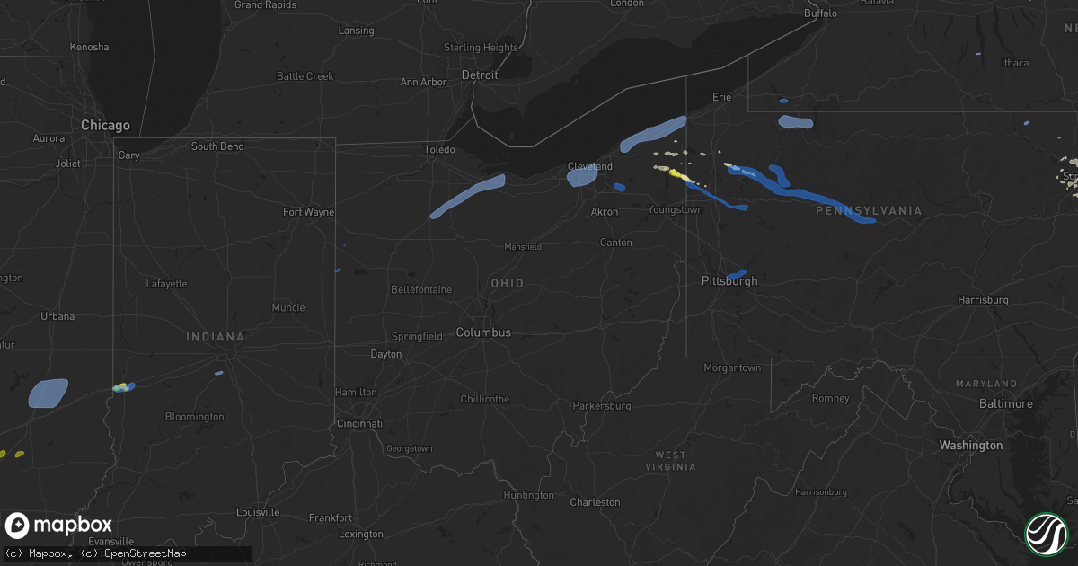
Hail Map in Ohio on August 17, 2019
Get this storm
August 17 map
$229
one time, instant access
Download today. No call, no setup
Keep the $229
Bought the map and want the full workflow? Apply the entire $229 to a subscription within 7 days. None of it is wasted.
Every map, not just this one
This buys you this map. Subscription and you get every map we run, in the markets you choose from a few cities to whole states to nationwide. Plus real-time alerts the moment a storm fires.
Contact data
Name, contact info, occupancy, even credit band for addresses in the footprint. You go from where it hit to who to call.
Become the source they trust
Unlimited branding weather history reports on demand. You already have the documented answer ready for the property owner, and you are the one who showed up with it.
Property data and RoofTrace estimates
Pull up any address you have got, its value and the exact code rules for that jurisdiction, straight from One Click Code. Then RoofTrace estimates the squares, pitch, and roof value, priced the way you price.
Storm reports in Ohio
Ohio
| Date | Description |
|---|---|
| 08/17/20192:59 PM CDT | 8 inch diameter limb down also. |
| 08/17/20192:46 PM CDT | A local report indicates 1.00 inch wind near 8 NNW ORANGEVILLE |
| 08/17/20192:33 PM CDT | One tree and one large branch blown down. Time estimated from radar data. |
| 08/17/20192:33 PM CDT | 30-40 ft tree down. |
| 08/17/20192:32 PM CDT | Several trees down in the area. |
| 08/17/20196:32 AM CDT | Tree down in conneaut. |
| 08/17/20196:24 AM CDT | Many trees down. |
| 08/17/20196:20 AM CDT | A section of tree down on house along with utility lines. Numerous 1-2 inch diameter limbs down as well. |
| 08/17/20196:14 AM CDT | Many trees down. |
| 08/17/20196:04 AM CDT | Large tree branch snapped off. |
| 08/17/20195:58 AM CDT | Trees down on route 84 near 528 in madison. |
| 08/17/20195:54 AM CDT | Tree and wires down on dewey road. |
| 08/17/20195:42 AM CDT | Many trees down in painesville. |
| 08/17/20195:16 AM CDT | Tree down on fairmount blvd. |
| 08/17/20195:06 AM CDT | Tree down on fence on west side of cleveland. |
| 08/17/20195:05 AM CDT | A large tree was blown down onto an exterior garage on haverhill ave near parma. |
| 08/17/20194:56 AM CDT | Delayed report: trees and wires down on w228. |
| 08/17/20194:54 AM CDT | Large tree down onto fence and playground set. |
| 08/17/20194:50 AM CDT | Also... Many tree limbs down. |
| 08/17/20193:56 AM CDT | Trees down. |
| 08/17/20193:16 AM CDT | Large tree branch down. |
| 08/17/20193:14 AM CDT | Tree down near us 224. |
| 08/17/20193:00 AM CDT | Tree down. |
| 08/17/20191:33 AM CDT | Damage to a turkey barn and a house. Time estimated from radar. |
| 08/17/20191:25 AM CDT | A couple of fields of corn stalks laid flat. |
| 08/17/20191:20 AM CDT | 40x60ft barn leveled. Sheet metal torn off another barn... Some sheet metal thrown 1/2mi se. Area of limbs/branches/trees down from sr 49 eastward to 1mi e of glenmore |
| 08/16/201910:33 PM CDT | At 333 PM EDT, a severe thunderstorm was located over Kinsman, or 14 miles northwest of Sharpsville, moving east at 25 mph. HAZARD...60 mph wind gusts and quarter size hail. SOURCE...Radar indicated. IMPACT...Minor damage to vehicles is possible. Expect damage to trees and power lines. Locations impacted include... Cortland, Kinsman, Mecca, Johnston and Orangeville. |
| 08/16/201910:31 PM CDT | At 331 PM EDT, a severe thunderstorm was located over Kinsman, or 13 miles northwest of Sharpsville, moving east at 30 mph. HAZARD...Wind gusts to 60 mph and quarter-size hail. SOURCE...Radar. IMPACT...Minor hail damage to vehicles is possible. Expect wind damage to trees and power lines, resulting in some power outages. Locations impacted include... Greenville... Stoneboro... Sandy Lake... Jamestown... Fredonia... New Lebanon... Sheakleyville... Maurice K Goddard State Park...This includes Interstate 79 in Pennsylvania between mile markers 125and 137. |
| 08/16/201910:29 PM CDT | At 329 PM EDT, a severe thunderstorm was located near Twinsburg, or 13 miles northwest of Ravenna, moving southeast at 20 mph. HAZARD...60 mph wind gusts and quarter size hail and heavy rain. SOURCE...Radar indicated. IMPACT...Minor damage to vehicles is possible. Expect damage to trees and power lines. Locations impacted include... Solon, Hudson, Twinsburg, Streetsboro, Warrensville Heights, Macedonia, South Russell, Highland Hills, Mantua, Maple Heights, Aurora, Bedford, Bedford Heights, Chagrin Falls, Northfield, Reminderville, Orange, Moreland Hills, Walton Hills and Boston Heights. |
All States Impacted by Hail Map on August 17, 2019
Cities Impacted by Hail Map on August 17, 2019
- Armour, SD
- Chokio, MN
- Newberry, SC
- Groton, SD
- Watertown, SD
- White River, SD
- Collyer, KS
- Wakeeney, KS
- Burke, SD
- Hamill, SD
- Gregory, SD
- Saint Francis, KS
- Carter, OK
- Ortonville, MN
- Newcastle, WY
- Bejou, MN
- Harrison, SD
- Platte, SD
- Geddes, SD
- Corsica, SD
- Witten, SD
- Ideal, SD
- Revillo, SD
- Big Stone City, SD
- Corona, SD
- Utica, KS
- Prosperity, SC
- Chittenango, NY
- Harrold, SD
- Trenton, IL
- Pukwana, SD
- Chamberlain, SD
- Vivian, SD
- Draper, SD
- Pierre, SD
- Presho, SD
- Mahnomen, MN
- Hill City, SD
- Correll, MN
- Fosston, MN
- Greenville, PA
- Towanda, KS
- El Dorado, KS
- Strandburg, SD
- Franklin, PA
- Oil City, PA
- White Lake, SD
- Odessa, MN
- Burghill, OH
- Kinsman, OH
- Factoryville, PA
- Dalton, PA
- Wood, SD
- Lake Andes, SD
- Barney, ND
- Lengby, MN
- Schenectady, NY
- Tunkhannock, PA
- Ramah, CO
- North Platte, NE
- Whitewood, SD
- Fairfax, SD
- Kimball, SD
- Plankinton, SD
- Highmore, SD
- Rapid City, SD
- Bellingham, MN
- Madison, MN
- Idalia, CO
- Wray, CO
- New Holland, SD
- Plainville, KS
- Ellis, KS
- Deadwood, SD
- Lead, SD
- Spearfish, SD
- Sturgis, SD
- Huntersville, NC
- Kinards, SC
- Whitmire, SC
- Waymart, PA
- Edgemont, SD
- Onida, SD
- Scranton, PA
- Clinton, MN
- Blunt, SD
- Piedmont, SD
- Nemo, SD
- Winger, MN
- Ogallah, KS
- Morris, MN
- Appleton, MN
- Kennebec, SD
- Cochranton, PA
- Utica, PA
- Barry, MN
- Graceville, MN
- Orwell, OH
- North Bloomfield, OH
- Saint Louis, MO
- Wagner, SD
- Dexter, KS
- Cedar Vale, KS
- Winner, SD
- Ree Heights, SD
- Waubun, MN
- Taylor, PA
- Olyphant, PA
- Jessup, PA
- Goodwin, SD
- Silverstreet, SC
- Farmdale, OH
- South Shore, SD
- Stockholm, SD
- Columbia, SD
- Bath, SD
- Carlyle, IL
- Coudersport, PA
- Burns, KS
- Naytahwaush, MN
- Lenoxville, PA
- Carbondale, PA
- Elk City, OK
- Chappells, SC
- Clearbrook, MN
- Fredonia, PA
- Jamestown, PA
- Glen Burnie, MD
- Pasadena, MD
- Maryland Heights, MO
- Cherryvale, KS
- Wessington, SD
- Upton, WY
- Delmont, SD
- Hazel, SD
- Linesville, PA
- Wolsey, SD
- Crownsville, MD
- Severna Park, MD
- Jermyn, PA
- Andover, OH
- Hulett, WY
- Saint Lawrence, SD
- Terre Haute, IN
- Burlington, CO
- Carlisle, SC
- Peckville, PA
- Duryea, PA
- Old Forge, PA
- Archbald, PA
- Moosic, PA
- Pittston, PA
- Bridgeport, NY
- Cicero, NY
- Murdo, SD
- Gann Valley, SD
- Wessington Springs, SD
- Fort Meade, SD
- Ballston Spa, NY
- Castlewood, SD
- Waverly, PA
- Clarks Summit, PA
- Mountville, SC
- West Terre Haute, IN
- Lower Brule, SD
- Harrison Valley, PA
- Genesee, PA
- Addieville, IL
- Okawville, IL
- Whitewater, KS
- Potwin, KS
- Dumont, MN
- Dorset, OH
- Hill City, KS
- Beardsley, MN
- Millersville, MD
- Rock Creek, OH
- Rome, OH
- Bagley, MN
- Limon, CO
- Hayti, SD
- Kranzburg, SD
- Cross Hill, SC
- Augusta, KS
- Labolt, SD
- Fort Thompson, SD
- Milbank, SD
- Saluda, SC
- Cassoday, KS
- Transfer, PA
- Batesburg, SC
- Gettysburg, SD
- Cooperstown, PA
- Inman, KS
- Roulette, PA
- Appleton, NY
- Barker, NY
- Gouldsboro, PA
- Newfoundland, PA
- Moscow, PA
- Wellsboro, PA
- Gaines, PA
- Williamsfield, OH
- Reliance, SD
- Wilkes Barre, PA
- Miller, SD
- Agate, CO
- Kiowa, CO
- Jefferson, OH
- Wyoming, PA
- Dallas, PA
- Fort Morgan, CO
- Wiggins, CO
- Stickney, SD
- Benton, KS
- Hutchinson, KS
- Shamrock, TX
- Mclean, TX
- Clinton, SC
- Port Allegany, PA
- Pickstown, SD
- Shavertown, PA
- Andover, KS
- Marietta, MN
- Russell, PA
- Warren, PA
- Blair, SC
- Lake Ariel, PA
- Forest City, PA
- Palco, KS
- Meadville, PA
- Woodrow, CO
- Akron, CO
- Conneaut Lake, PA
- Kirkville, NY
- Morland, KS
- Belle Fourche, SD
- Chesterfield, MO
- Burt, NY
- Olcott, NY
- Cortland, OH
- Youngsville, PA
- Sugar Grove, PA
- Irvine, PA
- Streetsboro, OH
- Aurora, OH
- Mantua, OH
- Charlotte, NC
- Ohio City, OH
- Coldwater, OH
- Celina, OH
- Fort Recovery, OH
- Findlay, OH
- Clyde, OH
- Monroeville, OH
- Bellevue, OH
- Vickery, OH
- Alvada, OH
- Castalia, OH
- Kansas, OH
- Old Fort, OH
- Tiffin, OH
- Sandusky, OH
- Green Springs, OH
- Fremont, OH
- Bettsville, OH
- Burgoon, OH
- Fostoria, OH
- Arcadia, OH
- Brookpark, OH
- Rocky River, OH
- Strongsville, OH
- Independence, OH
- Cleveland, OH
- Berea, OH
- North Royalton, OH
- Columbia Station, OH
- Westlake, OH
- North Olmsted, OH
- Olmsted Falls, OH
- Broadview Heights, OH
- Lakewood, OH
- Geneva, OH
- Conneaut, OH
- North Kingsville, OH
- Mentor, OH
- Ashtabula, OH
- Perry, OH
- West Springfield, PA
- Thompson, OH
- Austinburg, OH
- Painesville, OH
- Chardon, OH
- Kingsville, OH
- Madison, OH
- Lebanon, IL
- Mascoutah, IL
- New Baden, IL
- Kinmundy, IL
- Saint Peter, IL
- Louisville, IL
- Farina, IL
- Xenia, IL
- Ballwin, MO
- Cuttingsville, VT
- Plymouth, VT
- Mount Holly, VT
- West Hartford, VT
- Sharon, VT
- Norwich, VT
- White River Junction, VT
- Spirit Lake, IA
- Milford, IA
- George, IA
- Harris, IA
- Little Rock, IA
- Sibley, IA
- Lake Park, IA
- Terril, IA
- Arnolds Park, IA
- Ocheyedan, IA
- Okoboji, IA
- Rock Rapids, IA
- Greenwood, IN
- Mooresville, IN
- Bargersville, IN
- Martinsville, IN
- Bogue, KS
- Hays, KS
- Geneseo, KS
- Chase, KS
- Lyons, KS
- Russell, KS
- Brownell, KS
- Ransom, KS
- Gorham, KS
- Victoria, KS
- Little River, KS
- Windom, KS
- Walton, KS
- Newton, KS
- Hesston, KS
- Halstead, KS
- Quinter, KS
- Lecompton, KS
- Perry, KS
- Lawrence, KS
- Rosalia, KS
- Leon, KS
- Piedmont, KS
- Valley Falls, KS
- Ozawkie, KS
- Oskaloosa, KS
- Meriden, KS
- Kit Carson, CO
- Altus Afb, OK
- Elmer, OK
- Altus, OK
- Olustee, OK
- Headrick, OK
- Rushmore, MN
- Adrian, MN
- Reading, MN
- Worthington, MN
- Bigelow, MN
- Sisseton, SD
- New Effington, SD
- Rosholt, SD
- Independence, KS
- Greenup, IL
- Toledo, IL
- Trilla, IL
- Neoga, IL
- Westfield, IL
- Sigel, IL
- Ashmore, IL
- Mattoon, IL
- Lerna, IL
- Charleston, IL
- Gays, IL
- Windsor, IL
- Pfafftown, NC
- Winston Salem, NC
- Lewisville, NC
- Hilliards, PA
- Grove City, PA
- Boyers, PA
- Harrisville, PA
- Eau Claire, PA
- Sharpsville, PA
- Mercer, PA
- Parker, PA
- Fryburg, PA
- Reynoldsville, PA
- Falls Creek, PA
- Sigel, PA
- Cranberry, PA
- Corsica, PA
- Penfield, PA
- Rouseville, PA
- Carlton, PA
- Hyde, PA
- West Decatur, PA
- Seneca, PA
- Shippenville, PA
- Mineral Springs, PA
- Marble, PA
- Clarion, PA
- Clearfield, PA
- Brookville, PA
- Brockway, PA
- Venus, PA
- Morrisdale, PA
- Woodland, PA
- Reno, PA
- Bigler, PA
- Lucinda, PA
- Du Bois, PA
- Strattanville, PA
- Clarington, PA
- Rockton, PA
- Lickingville, PA
- Leeper, PA
- Pleasantville, PA
- Tionesta, PA
- Pittsburgh, PA
- Oakmont, PA
- Springdale, PA
- New Kensington, PA
- Cheswick, PA
- Verona, PA
- Rome, PA
- Ulster, PA
- Montrose, PA
- Wells, VT
- West Pawlet, VT
- Granville, NY
- Poultney, VT
- West Rutland, VT
- Proctor, VT
- Moundridge, KS
- North Newton, KS
- Walker, KS
- Holyrood, KS
- Lorraine, KS
- Mcpherson, KS
- Canton, KS
- Claflin, KS
- Kanopolis, KS
- Valley Center, KS
- Marquette, KS
- Wilson, KS
- Peabody, KS
- Elbing, KS
- Ellsworth, KS
- Galva, KS
- Bunker Hill, KS
- Dorrance, KS
- Hoisington, KS
- Baldwinsville, NY
- Memphis, NY
- Weedsport, NY
- Cato, NY
- Jordan, NY
- East Syracuse, NY
- Syracuse, NY
- Oneida, NY
- Durhamville, NY
- Minoa, NY
- Canastota, NY
- Lakewood, NY
- Jamestown, NY
- Ashville, NY
- Hagaman, NY
- Galway, NY
- Rexford, NY
- Alplaus, NY
- Clifton Park, NY
- Rome, NY
- Whitesboro, NY
- Westmoreland, NY
- Oriskany, NY
- Clinton, NY
- Cobleskill, NY
- Esperance, NY
- Sloansville, NY
- Delanson, NY
- Lake Luzerne, NY
- Greenfield Center, NY
- Corinth, NY
- Porter Corners, NY
- Fort Edward, NY
- Gansevoort, NY
- Saratoga Springs, NY
- Stillwater, NY
- Schaghticoke, NY
- Mechanicville, NY
- Freeman, VA
- Emporia, VA
- Lawrenceville, VA
- Iona, MN
- Westbrook, MN
- Kenneth, MN
- Amboy, MN
- Granada, MN
- Wilmont, MN
- Pemberton, MN
- Emery, SD
- Hartford, SD
- Heron Lake, MN
- Brewster, MN
- Egan, SD
- Bingham Lake, MN
- Odin, MN
- Eagle Lake, MN
- Waseca, MN
- Avoca, MN
- Dell Rapids, SD
- Minnesota Lake, MN
- Montrose, SD
- Garretson, SD
- Chandler, MN
- Chester, SD
- Vernon Center, MN
- Waldorf, MN
- Madison, SD
- Jasper, MN
- Lakefield, MN
- Edgerton, MN
- Humboldt, SD
- Saint Clair, MN
- Winnebago, MN
- Fulton, SD
- Truman, MN
- Good Thunder, MN
- Janesville, MN
- Storden, MN
- Mitchell, SD
- Mount Vernon, SD
- Leota, MN
- Mapleton, MN
- Lake Crystal, MN
- Wentworth, SD
- Fairmont, MN
- Spencer, SD
- Colman, SD
- Slayton, MN
- Fulda, MN
- Butterfield, MN
- Baltic, SD
- Garden City, MN
- Hardwick, MN
- Bridgewater, SD
- Trent, SD
- Lismore, MN
- Windom, MN
- Pipestone, MN
- Alexandria, SD
- Holland, MN
- Madelia, MN
- Saint James, MN
- Easton, MN
- Mountain Lake, MN
- Ormsby, MN
- Woodstock, MN
- Flandreau, SD
- Winfred, SD
- Mankato, MN
- Delavan, MN
- Trimont, MN
- Salem, SD
- Lake Wilson, MN
- Currie, MN
- Lewisville, MN
- Colton, SD
- Oacoma, SD
- Dundee, NY
- Schoharie, NY
- Brazil, IN
- Kittrell, NC
- Goodland, KS
- Kanorado, KS
- Edson, KS


