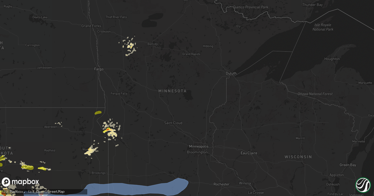
Hail Map in Minnesota on August 17, 2019
Get this storm
August 17 map
$229
one time, instant access
Download today. No call, no setup
Keep the $229
Bought the map and want the full workflow? Apply the entire $229 to a subscription within 7 days. None of it is wasted.
Every map, not just this one
This buys you this map. Subscription and you get every map we run, in the markets you choose from a few cities to whole states to nationwide. Plus real-time alerts the moment a storm fires.
Contact data
Name, contact info, occupancy, even credit band for addresses in the footprint. You go from where it hit to who to call.
Become the source they trust
Unlimited branding weather history reports on demand. You already have the documented answer ready for the property owner, and you are the one who showed up with it.
Property data and RoofTrace estimates
Pull up any address you have got, its value and the exact code rules for that jurisdiction, straight from One Click Code. Then RoofTrace estimates the squares, pitch, and roof value, priced the way you price.
Storm reports in Minnesota
Minnesota
| Date | Description |
|---|---|
| 08/17/20196:57 PM CDT | Wind speed estimated 40-50mph. Relayed through nws fgf. |
| 08/17/20196:53 PM CDT | Large tree limbs down. Time estimated from radar. |
| 08/17/20195:24 PM CDT | Mostly quarter sized hail... Some bigger. Time estimated based on radar. |
| 08/17/20196:39 AM CDT | At 1138 PM CDT, severe thunderstorms were located along a line extending from near Jackson In Jackson County to near Superior to near Milford, moving east at 60 mph. HAZARD...60 mph wind gusts and quarter size hail. SOURCE...Radar indicated. IMPACT...Hail damage to vehicles is expected. Expect wind damage to roofs, siding, and trees. Locations impacted include... Estherville, Emmetsburg, Swan Lake, Five Island Lake, Ingham Lake, High Lake, Lost Island Lake, Okamanpedan Lake, Iowa Lake, Union Slogh, Armstrong, Graettinger, Ruthven, Bancroft, Swea City, Burt, Ringsted, Fenton, Lakota and Wallingford. |
| 08/17/20196:26 AM CDT | At 1125 PM CDT, severe thunderstorms were located along a line extending from near Storden to near Lakefield, moving northeast at 60 mph. HAZARD...60 mph wind gusts and quarter size hail. SOURCE...Public. IMPACT...Hail damage to vehicles is expected. Expect wind damage to roofs, siding, and trees. Locations impacted include... St. James, Sleepy Eye, Madelia, Springfield, Butterfield, Hanska, Comfrey, Lewisville, South Branch, Darfur, Odin and La Salle.This includes U.S. Highway 14 between mile markers 69 and 90. |
| 08/17/20194:52 AM CDT | At 952 PM CDT, severe thunderstorms were located along a line extending from near Sinai to near Wentworth to near Colton, moving east at 45 mph. HAZARD...60 mph wind gusts and quarter size hail. SOURCE...Radar indicated. IMPACT...Hail damage to vehicles is expected. Expect wind damage to roofs, siding, and trees. Severe thunderstorms will be near... Colton and Chester around 955 PM CDT. Volga, Baltic and Colman around 1005 PM CDT. Brookings around 1010 PM CDT. Flandreau, Egan and Trent around 1015 PM CDT. Aurora and Palisades State Park around 1020 PM CDT. Garretson and Sherman around 1025 PM CDT. Pipestone, Elkton, Jasper and Pipestone National Monument around 1030 PM CDT.Other locations impacted by these severe thunderstorms includeBushnell and Ihlen. |
| 08/17/20193:13 AM CDT | At 813 PM CDT, a severe thunderstorm was located near Madison, or 18 miles west of Montevideo, moving east at 30 mph. HAZARD...60 mph wind gusts and half dollar size hail. SOURCE...Radar indicated. IMPACT...Hail damage to vehicles is expected. Expect wind damage to roofs, siding, and trees. Locations impacted include... Montevideo, Madison, Dawson, Milan, Watson, Cerro Gordo, Big Bend City, Madison Airport and Montevideo Airport.This includes the following highways... U.S. Highway 212 between mile markers 10 and 37. U.S. Highway 75 between mile markers 98 and 112. U.S. Highway 59 between mile markers 106 and 107. |
| 08/17/20192:59 AM CDT | At 758 PM CDT, a severe thunderstorm was located near Correll, or 14 miles east of Ortonville, moving east at 20 mph. HAZARD...60 mph wind gusts and half dollar size hail. SOURCE...Radar indicated. IMPACT...Hail damage to vehicles is expected. Expect wind damage to roofs, siding, and trees. Locations impacted include... Appleton, Lake Oliver, Artichoke Lake, Louisburg and Appleton Airport.This includes the following highways... U.S. Highway 12 between mile markers 17 and 25. U.S. Highway 75 between mile markers 126 and 127. U.S. Highway 59 between mile markers 136 and 140. |
| 08/17/20192:44 AM CDT | At 744 PM CDT, a severe thunderstorm was located near Correll, or 10 miles east of Ortonville, moving east at 15 mph. HAZARD...Ping pong ball size hail and 60 mph wind gusts. SOURCE...Radar indicated. IMPACT...People and animals outdoors will be injured. Expect hail damage to roofs, siding, windows, and vehicles. Expect wind damage to roofs, siding, and trees. Locations impacted include... Odessa, Correll and Artichoke Lake. |
| 08/17/20192:11 AM CDT | At 711 PM CDT, a severe thunderstorm was located near Clinton, or 9 miles northeast of Ortonville, moving east at 15 mph. HAZARD...60 mph wind gusts and quarter size hail. SOURCE...Radar indicated. IMPACT...Hail damage to vehicles is expected. Expect wind damage to roofs, siding, and trees. Locations impacted include... Artichoke and Artichoke Lake. |
| 08/17/20191:46 AM CDT | At 645 PM CDT, a severe thunderstorm was located near Alida, or 21 miles southwest of Bemidji, moving east at 30 mph. HAZARD...60 mph wind gusts and quarter size hail. SOURCE...Radar indicated. IMPACT...Hail damage to vehicles is expected. Expect wind damage to roofs, siding, and trees. Locations impacted include... Bemidji, Plantagenet Lake, Lavinia, Guthrie, Lake Itasca, Rosby and Alida. |
| 08/17/20191:18 AM CDT | One large branch and several smaller branches down. Time estimated from radar. Twitter. |
| 08/17/20191:09 AM CDT | Tree down on powerline with tree on fire - delayed report... Time estimated from radar. |
| 08/17/201912:54 AM CDT | Large tree fell on house in janesville - delayed report... Time estimated from radar. |
| 08/17/201912:43 AM CDT | A couple trees down in mankato - delayed report... Time estimated from radar. |
| 08/17/201912:33 AM CDT | Tree damage in mapleton and damage to transformer - delayed report... Time estimated from radar. |
| 08/17/201912:25 AM CDT | 2-3 inch diameter branches down. |
| 08/17/201912:20 AM CDT | 6-8 inch diameter branch down. |
| 08/17/201912:14 AM CDT | Powerlines down in medilia... Also trees down across the county - delayed report... Time estimated from radar. |
| 08/17/201912:09 AM CDT | At 509 PM CDT, a severe thunderstorm was located over Fosston moving northeast at 30 mph. HAZARD...60 mph wind gusts and quarter size hail. SOURCE...Radar indicated. IMPACT...Hail damage to vehicles is expected. Expect wind damage to roofs, siding, and trees. This severe thunderstorm will be near... Olga around 525 PM CDT. Weme around 530 PM CDT. Clearbrook and Gonvick around 540 PM CDT. Berner around 550 PM CDT. |
| 08/17/201912:03 AM CDT | Powerlines down in st james - delayed report... Time estimated from radar. |
| 08/16/201911:54 PM CDT | Large tree down that caused gas leak - delayed report... Time estimated from radar. |
| 08/16/201911:50 PM CDT | Rwis station. |
| 08/16/201911:45 PM CDT | Tree branches down blocking the road at 12th street and miller ave on the east side of town. |
| 08/16/201911:31 PM CDT | At 431 PM CDT, a severe thunderstorm was located over Lockhart moving east at 40 mph. HAZARD...60 mph wind gusts and quarter size hail. SOURCE...Radar indicated. IMPACT...Hail damage to vehicles is expected. Expect wind damage to roofs, siding, and trees. Locations impacted include... Fertile, Winger, Gary, Beltrami, Bejou, Lockhart and Rindal. |
| 08/16/201911:25 PM CDT | Start of 1/2 mile path. Corn flattened and shredded. Max path width of 20 yards. |
| 08/16/201911:14 PM CDT | Start of slightly over one mile long damage path. During the two-minute tornado... Some damage was done to farm outbuildings and corn was flattened. |
| 08/16/201911:08 PM CDT | Start of nearly mile long damage path. Over the path... Corn was flattened... Several trees damaged and an old barn destroyed. |
| 08/16/201911:03 PM CDT | End of 4 mile damage path. |
| 08/16/201910:59 PM CDT | Start of damage path. Trees uprooted with several large branches down. |
| 08/16/201910:59 PM CDT | Start of damage path. Corn flattened. |
| 08/16/201910:57 PM CDT | Time estimated based on radar. Additional detail from storm survey will be compiled monday... 8-19-2019. |
| 08/16/201910:56 PM CDT | Structural damage to a pair of garages in town. One garage blown off its foundation with cinder blocks from foundation rolled northeast. Additional damage to trees in t |
| 08/16/201910:53 PM CDT | Power lines down in wilmont. Picture via social media. |
| 08/16/201910:48 PM CDT | Garage blown off of foundation. Numerous large tree limbs down. |
| 08/16/201910:46 PM CDT | Several branches down. Time estimated based on radar. |
| 08/16/201910:32 PM CDT | Some power outages reported around town. |
| 08/16/201910:27 PM CDT | Corrects time of previous tstm wnd gst report from pipestone. Some power outages reported around town. |
| 08/16/20197:47 PM CDT | Lots of hail with some quarters. Shredded bean fields and cattails east of property. |
| 08/16/20197:15 PM CDT | Time estimated by radar. |
All States Impacted by Hail Map on August 17, 2019
Cities Impacted by Hail Map on August 17, 2019
- Armour, SD
- Chokio, MN
- Newberry, SC
- Groton, SD
- Watertown, SD
- White River, SD
- Collyer, KS
- Wakeeney, KS
- Burke, SD
- Hamill, SD
- Gregory, SD
- Saint Francis, KS
- Carter, OK
- Ortonville, MN
- Newcastle, WY
- Bejou, MN
- Harrison, SD
- Platte, SD
- Geddes, SD
- Corsica, SD
- Witten, SD
- Ideal, SD
- Revillo, SD
- Big Stone City, SD
- Corona, SD
- Utica, KS
- Prosperity, SC
- Chittenango, NY
- Harrold, SD
- Trenton, IL
- Pukwana, SD
- Chamberlain, SD
- Vivian, SD
- Draper, SD
- Pierre, SD
- Presho, SD
- Mahnomen, MN
- Hill City, SD
- Correll, MN
- Fosston, MN
- Greenville, PA
- Towanda, KS
- El Dorado, KS
- Strandburg, SD
- Franklin, PA
- Oil City, PA
- White Lake, SD
- Odessa, MN
- Burghill, OH
- Kinsman, OH
- Factoryville, PA
- Dalton, PA
- Wood, SD
- Lake Andes, SD
- Barney, ND
- Lengby, MN
- Schenectady, NY
- Tunkhannock, PA
- Ramah, CO
- North Platte, NE
- Whitewood, SD
- Fairfax, SD
- Kimball, SD
- Plankinton, SD
- Highmore, SD
- Rapid City, SD
- Bellingham, MN
- Madison, MN
- Idalia, CO
- Wray, CO
- New Holland, SD
- Plainville, KS
- Ellis, KS
- Deadwood, SD
- Lead, SD
- Spearfish, SD
- Sturgis, SD
- Huntersville, NC
- Kinards, SC
- Whitmire, SC
- Waymart, PA
- Edgemont, SD
- Onida, SD
- Scranton, PA
- Clinton, MN
- Blunt, SD
- Piedmont, SD
- Nemo, SD
- Winger, MN
- Ogallah, KS
- Morris, MN
- Appleton, MN
- Kennebec, SD
- Cochranton, PA
- Utica, PA
- Barry, MN
- Graceville, MN
- Orwell, OH
- North Bloomfield, OH
- Saint Louis, MO
- Wagner, SD
- Dexter, KS
- Cedar Vale, KS
- Winner, SD
- Ree Heights, SD
- Waubun, MN
- Taylor, PA
- Olyphant, PA
- Jessup, PA
- Goodwin, SD
- Silverstreet, SC
- Farmdale, OH
- South Shore, SD
- Stockholm, SD
- Columbia, SD
- Bath, SD
- Carlyle, IL
- Coudersport, PA
- Burns, KS
- Naytahwaush, MN
- Lenoxville, PA
- Carbondale, PA
- Elk City, OK
- Chappells, SC
- Clearbrook, MN
- Fredonia, PA
- Jamestown, PA
- Glen Burnie, MD
- Pasadena, MD
- Maryland Heights, MO
- Cherryvale, KS
- Wessington, SD
- Upton, WY
- Delmont, SD
- Hazel, SD
- Linesville, PA
- Wolsey, SD
- Crownsville, MD
- Severna Park, MD
- Jermyn, PA
- Andover, OH
- Hulett, WY
- Saint Lawrence, SD
- Terre Haute, IN
- Burlington, CO
- Carlisle, SC
- Peckville, PA
- Duryea, PA
- Old Forge, PA
- Archbald, PA
- Moosic, PA
- Pittston, PA
- Bridgeport, NY
- Cicero, NY
- Murdo, SD
- Gann Valley, SD
- Wessington Springs, SD
- Fort Meade, SD
- Ballston Spa, NY
- Castlewood, SD
- Waverly, PA
- Clarks Summit, PA
- Mountville, SC
- West Terre Haute, IN
- Lower Brule, SD
- Harrison Valley, PA
- Genesee, PA
- Addieville, IL
- Okawville, IL
- Whitewater, KS
- Potwin, KS
- Dumont, MN
- Dorset, OH
- Hill City, KS
- Beardsley, MN
- Millersville, MD
- Rock Creek, OH
- Rome, OH
- Bagley, MN
- Limon, CO
- Hayti, SD
- Kranzburg, SD
- Cross Hill, SC
- Augusta, KS
- Labolt, SD
- Fort Thompson, SD
- Milbank, SD
- Saluda, SC
- Cassoday, KS
- Transfer, PA
- Batesburg, SC
- Gettysburg, SD
- Cooperstown, PA
- Inman, KS
- Roulette, PA
- Appleton, NY
- Barker, NY
- Gouldsboro, PA
- Newfoundland, PA
- Moscow, PA
- Wellsboro, PA
- Gaines, PA
- Williamsfield, OH
- Reliance, SD
- Wilkes Barre, PA
- Miller, SD
- Agate, CO
- Kiowa, CO
- Jefferson, OH
- Wyoming, PA
- Dallas, PA
- Fort Morgan, CO
- Wiggins, CO
- Stickney, SD
- Benton, KS
- Hutchinson, KS
- Shamrock, TX
- Mclean, TX
- Clinton, SC
- Port Allegany, PA
- Pickstown, SD
- Shavertown, PA
- Andover, KS
- Marietta, MN
- Russell, PA
- Warren, PA
- Blair, SC
- Lake Ariel, PA
- Forest City, PA
- Palco, KS
- Meadville, PA
- Woodrow, CO
- Akron, CO
- Conneaut Lake, PA
- Kirkville, NY
- Morland, KS
- Belle Fourche, SD
- Chesterfield, MO
- Burt, NY
- Olcott, NY
- Cortland, OH
- Youngsville, PA
- Sugar Grove, PA
- Irvine, PA
- Streetsboro, OH
- Aurora, OH
- Mantua, OH
- Charlotte, NC
- Ohio City, OH
- Coldwater, OH
- Celina, OH
- Fort Recovery, OH
- Findlay, OH
- Clyde, OH
- Monroeville, OH
- Bellevue, OH
- Vickery, OH
- Alvada, OH
- Castalia, OH
- Kansas, OH
- Old Fort, OH
- Tiffin, OH
- Sandusky, OH
- Green Springs, OH
- Fremont, OH
- Bettsville, OH
- Burgoon, OH
- Fostoria, OH
- Arcadia, OH
- Brookpark, OH
- Rocky River, OH
- Strongsville, OH
- Independence, OH
- Cleveland, OH
- Berea, OH
- North Royalton, OH
- Columbia Station, OH
- Westlake, OH
- North Olmsted, OH
- Olmsted Falls, OH
- Broadview Heights, OH
- Lakewood, OH
- Geneva, OH
- Conneaut, OH
- North Kingsville, OH
- Mentor, OH
- Ashtabula, OH
- Perry, OH
- West Springfield, PA
- Thompson, OH
- Austinburg, OH
- Painesville, OH
- Chardon, OH
- Kingsville, OH
- Madison, OH
- Lebanon, IL
- Mascoutah, IL
- New Baden, IL
- Kinmundy, IL
- Saint Peter, IL
- Louisville, IL
- Farina, IL
- Xenia, IL
- Ballwin, MO
- Cuttingsville, VT
- Plymouth, VT
- Mount Holly, VT
- West Hartford, VT
- Sharon, VT
- Norwich, VT
- White River Junction, VT
- Spirit Lake, IA
- Milford, IA
- George, IA
- Harris, IA
- Little Rock, IA
- Sibley, IA
- Lake Park, IA
- Terril, IA
- Arnolds Park, IA
- Ocheyedan, IA
- Okoboji, IA
- Rock Rapids, IA
- Greenwood, IN
- Mooresville, IN
- Bargersville, IN
- Martinsville, IN
- Bogue, KS
- Hays, KS
- Geneseo, KS
- Chase, KS
- Lyons, KS
- Russell, KS
- Brownell, KS
- Ransom, KS
- Gorham, KS
- Victoria, KS
- Little River, KS
- Windom, KS
- Walton, KS
- Newton, KS
- Hesston, KS
- Halstead, KS
- Quinter, KS
- Lecompton, KS
- Perry, KS
- Lawrence, KS
- Rosalia, KS
- Leon, KS
- Piedmont, KS
- Valley Falls, KS
- Ozawkie, KS
- Oskaloosa, KS
- Meriden, KS
- Kit Carson, CO
- Altus Afb, OK
- Elmer, OK
- Altus, OK
- Olustee, OK
- Headrick, OK
- Rushmore, MN
- Adrian, MN
- Reading, MN
- Worthington, MN
- Bigelow, MN
- Sisseton, SD
- New Effington, SD
- Rosholt, SD
- Independence, KS
- Greenup, IL
- Toledo, IL
- Trilla, IL
- Neoga, IL
- Westfield, IL
- Sigel, IL
- Ashmore, IL
- Mattoon, IL
- Lerna, IL
- Charleston, IL
- Gays, IL
- Windsor, IL
- Pfafftown, NC
- Winston Salem, NC
- Lewisville, NC
- Hilliards, PA
- Grove City, PA
- Boyers, PA
- Harrisville, PA
- Eau Claire, PA
- Sharpsville, PA
- Mercer, PA
- Parker, PA
- Fryburg, PA
- Reynoldsville, PA
- Falls Creek, PA
- Sigel, PA
- Cranberry, PA
- Corsica, PA
- Penfield, PA
- Rouseville, PA
- Carlton, PA
- Hyde, PA
- West Decatur, PA
- Seneca, PA
- Shippenville, PA
- Mineral Springs, PA
- Marble, PA
- Clarion, PA
- Clearfield, PA
- Brookville, PA
- Brockway, PA
- Venus, PA
- Morrisdale, PA
- Woodland, PA
- Reno, PA
- Bigler, PA
- Lucinda, PA
- Du Bois, PA
- Strattanville, PA
- Clarington, PA
- Rockton, PA
- Lickingville, PA
- Leeper, PA
- Pleasantville, PA
- Tionesta, PA
- Pittsburgh, PA
- Oakmont, PA
- Springdale, PA
- New Kensington, PA
- Cheswick, PA
- Verona, PA
- Rome, PA
- Ulster, PA
- Montrose, PA
- Wells, VT
- West Pawlet, VT
- Granville, NY
- Poultney, VT
- West Rutland, VT
- Proctor, VT
- Moundridge, KS
- North Newton, KS
- Walker, KS
- Holyrood, KS
- Lorraine, KS
- Mcpherson, KS
- Canton, KS
- Claflin, KS
- Kanopolis, KS
- Valley Center, KS
- Marquette, KS
- Wilson, KS
- Peabody, KS
- Elbing, KS
- Ellsworth, KS
- Galva, KS
- Bunker Hill, KS
- Dorrance, KS
- Hoisington, KS
- Baldwinsville, NY
- Memphis, NY
- Weedsport, NY
- Cato, NY
- Jordan, NY
- East Syracuse, NY
- Syracuse, NY
- Oneida, NY
- Durhamville, NY
- Minoa, NY
- Canastota, NY
- Lakewood, NY
- Jamestown, NY
- Ashville, NY
- Hagaman, NY
- Galway, NY
- Rexford, NY
- Alplaus, NY
- Clifton Park, NY
- Rome, NY
- Whitesboro, NY
- Westmoreland, NY
- Oriskany, NY
- Clinton, NY
- Cobleskill, NY
- Esperance, NY
- Sloansville, NY
- Delanson, NY
- Lake Luzerne, NY
- Greenfield Center, NY
- Corinth, NY
- Porter Corners, NY
- Fort Edward, NY
- Gansevoort, NY
- Saratoga Springs, NY
- Stillwater, NY
- Schaghticoke, NY
- Mechanicville, NY
- Freeman, VA
- Emporia, VA
- Lawrenceville, VA
- Iona, MN
- Westbrook, MN
- Kenneth, MN
- Amboy, MN
- Granada, MN
- Wilmont, MN
- Pemberton, MN
- Emery, SD
- Hartford, SD
- Heron Lake, MN
- Brewster, MN
- Egan, SD
- Bingham Lake, MN
- Odin, MN
- Eagle Lake, MN
- Waseca, MN
- Avoca, MN
- Dell Rapids, SD
- Minnesota Lake, MN
- Montrose, SD
- Garretson, SD
- Chandler, MN
- Chester, SD
- Vernon Center, MN
- Waldorf, MN
- Madison, SD
- Jasper, MN
- Lakefield, MN
- Edgerton, MN
- Humboldt, SD
- Saint Clair, MN
- Winnebago, MN
- Fulton, SD
- Truman, MN
- Good Thunder, MN
- Janesville, MN
- Storden, MN
- Mitchell, SD
- Mount Vernon, SD
- Leota, MN
- Mapleton, MN
- Lake Crystal, MN
- Wentworth, SD
- Fairmont, MN
- Spencer, SD
- Colman, SD
- Slayton, MN
- Fulda, MN
- Butterfield, MN
- Baltic, SD
- Garden City, MN
- Hardwick, MN
- Bridgewater, SD
- Trent, SD
- Lismore, MN
- Windom, MN
- Pipestone, MN
- Alexandria, SD
- Holland, MN
- Madelia, MN
- Saint James, MN
- Easton, MN
- Mountain Lake, MN
- Ormsby, MN
- Woodstock, MN
- Flandreau, SD
- Winfred, SD
- Mankato, MN
- Delavan, MN
- Trimont, MN
- Salem, SD
- Lake Wilson, MN
- Currie, MN
- Lewisville, MN
- Colton, SD
- Oacoma, SD
- Dundee, NY
- Schoharie, NY
- Brazil, IN
- Kittrell, NC
- Goodland, KS
- Kanorado, KS
- Edson, KS


