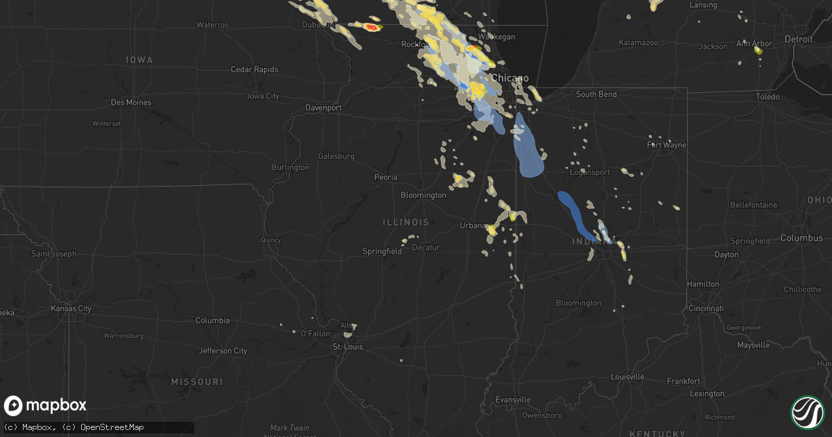
Hail Map in Illinois on August 16, 2025
Get this storm
August 16 map
$229
one time, instant access
Download today. No call, no setup
Keep the $229
Bought the map and want the full workflow? Apply the entire $229 to a subscription within 7 days. None of it is wasted.
Every map, not just this one
This buys you this map. Subscription and you get every map we run, in the markets you choose from a few cities to whole states to nationwide. Plus real-time alerts the moment a storm fires.
Contact data
Name, contact info, occupancy, even credit band for addresses in the footprint. You go from where it hit to who to call.
Become the source they trust
Unlimited branding weather history reports on demand. You already have the documented answer ready for the property owner, and you are the one who showed up with it.
Property data and RoofTrace estimates
Pull up any address you have got, its value and the exact code rules for that jurisdiction, straight from One Click Code. Then RoofTrace estimates the squares, pitch, and roof value, priced the way you price.
Storm reports in Illinois
Illinois
| Date | Description |
|---|---|
| 08/16/20256:48 PM CDT | Delayed report. Received pictures and video of a tornado briefly touching down just north of homer... Il in a field. Ef-u. |
| 08/16/20256:48 PM CDT | Corrects previous tornado report from 1 n homer. Drone footage showed a barn lost its roof and corn damage was seen along catlin-homer road just west of county road 200 |
| 08/16/20255:57 PM CDT | Public report of small branches broken east of manhattan. |
| 08/16/20255:44 PM CDT | Whole trees snapped in the vicinity of lockport high school baseball fields. |
| 08/16/20255:43 PM CDT | Multiple photos shared to social media show large branches broken in lockport. Some branches at least several inches in diameter. One large trunk of a rotted tree fell |
| 08/16/20255:40 PM CDT | Very large tree limbs snapped and blown down the street. |
| 08/16/20255:35 PM CDT | Gas station canopy damaged and tilting. Tree damage in the vicinity extends from normantown road to romeoville high school. Multiple branches around 12 inches in diamet |
| 08/16/20255:35 PM CDT | Photo shared to social media shows roofing material pulled from strip mall near romeo road and il-53. Time estimated by radar. |
| 08/16/20255:22 PM CDT | Public report of a large tree branch downed in arlington heights. |
| 08/16/20255:14 PM CDT | Relayed via mping. |
| 08/16/20255:14 PM CDT | Relayed via mping. |
| 08/16/20255:12 PM CDT | Photo shared on social media shows 1 hail. |
| 08/16/20255:06 PM CDT | Photo shared on social media showed a large section of a healthy tree split and blocking part of a residential road. |
| 08/16/20255:03 PM CDT | Photos shared on social media show several 3 to 6 inch diameter tree limbs down as well as a 12 inch diameter tree snapped at base in the vicinity of the intersection o |
| 08/16/20254:55 PM CDT | Trees up to one foot diameter downed or split. Multiple trees blocking bliss road. Time estimated from radar and other reports. |
| 08/16/20254:53 PM CDT | Photo shows large branch broken near pleasant avenue and castle street in sandwich. Time estimated by radar. |
| 08/16/20254:44 PM CDT | Flattened corn near main street just west of bunker road. Time estimated by radar. |
| 08/16/20254:44 PM CDT | Report from mping: half dollar |
| 08/16/20254:40 PM CDT | Newspaper article with pictures showing numerous tents blowen around and destroyed at the niles founders day festivities at golf mill park. Also was some downed trees. |
| 08/16/20254:39 PM CDT | Report from mping: quarter (1.0 |
| 08/16/20254:39 PM CDT | Power pole snapped near harter road and county line road south of maple park. Time estimated by rada |
| 08/16/20254:39 PM CDT | Power pole snapped near harter road and county line road south of maple park. Time estimated by radar. |
| 08/16/20254:39 PM CDT | Report from mping: quarter |
| 08/16/20254:38 PM CDT | A local report indicates 1.00 inch wind near 1 S Des Plaines |
| 08/16/20254:35 PM CDT | Portion of roof removed from apartment building near huntington commons road and linneman road in mount prospect. Photo shared via social media shows debris from roof d |
| 08/16/20254:33 PM CDT | 1333 chicago ave. |
| 08/16/20254:30 PM CDT | Photos and videos shared to social media show few inch diameter branches downed. Rotted tree uprooted or snapped in vicinity. Time estimated by radar. |
| 08/16/20254:28 PM CDT | Harper college. Multiple large branches also broken. |
| 08/16/20254:26 PM CDT | Photo shared to social media shows large tree branch broken between dekalb and sycamore. Time estimated by radar. |
| 08/16/20254:26 PM CDT | A local report indicates 73 MPH wind near 3 NNW DeKalb |
| 08/16/20254:25 PM CDT | Multiple photos shared to social media show numerous branches broken southeast of palatine. Most branches at least multiple inches in diameter. At least one tree trunk |
| 08/16/20254:25 PM CDT | A local report indicates 1.25 inch wind near 1 E Palatine |
| 08/16/20254:23 PM CDT | Several tree limbs 8 to 12 inches in diameter were blown down near mundhank road and south freeman road. |
| 08/16/20254:22 PM CDT | 1 ft diameter tree snapped at spaulding and stroger. |
| 08/16/20254:21 PM CDT | Photos depict an uprooted softwood tree and 8 to 12 inch diameter tree limb snapped in the vicinity of greenbrier court. Time estimated by radar. |
| 08/16/20254:10 PM CDT | Near rt 47 and plato. |
| 08/16/20254:10 PM CDT | 1 inch diameter branches broken near elgin due to thunderstorm outflow. |
| 08/16/20254:08 PM CDT | Village of barrington reported via social media that multiple tree branches broken in the area. Public report of large tree branch blocking oak knoll road west of barri |
| 08/16/20254:06 PM CDT | Photo shared via social media shows several inch diameter branch broken near northwest highway and kelsey road. Time estimated by radar. |
| 08/16/20254:05 PM CDT | Relayed via mping. |
| 08/16/20254:05 PM CDT | Downed trees... Branches... And power lines. Hail of unknown size as well. Time estimated from radar. |
| 08/16/20254:04 PM CDT | Relayed via mping. |
| 08/16/20254:02 PM CDT | Numerous photos shared to social media of large branches broken in and near cary. At least one tree uprooted. Time estimated by radar. |
| 08/16/20254:02 PM CDT | Public report of multiple branches broken from tree near carpentersville. |
| 08/16/20254:00 PM CDT | Many large trees uprooted... Large branches broken... And parts of corn fields flattened near oak lawn farm |
| 08/16/20253:54 PM CDT | Report from mping: quarter |
| 08/16/20253:51 PM CDT | Photo shared to social media shows large branched broken from tops of trees near main street and cary road in algonquin. Time estimated by radar. |
| 08/16/20253:51 PM CDT | Relayed via mping. |
| 08/16/20253:51 PM CDT | Tree down on 3 cars on webster street near rt 62 and 31. Time estimated by radar. |
| 08/16/20253:51 PM CDT | Relayed via mping. |
| 08/16/20253:50 PM CDT | Updated report. Two two-foot diameter trees downed near jackson and gardner in belvidere. Time estimated by radar. |
| 08/16/20253:47 PM CDT | 6-12 inch diameter branches broken near jackson and gardner in belvidere. |
| 08/16/20253:47 PM CDT | Numerous trees down... Some into powerlines and on cars. Time estimated by radar. |
| 08/16/20253:45 PM CDT | Woodstock police department reports multiple power lines downed in woodstock. Relayed by mchenry county ema. Time estimated by radar. |
| 08/16/20253:42 PM CDT | Boone county em reports numerous trees down along the southeast side of town. Time estimated by radar. |
| 08/16/20253:40 PM CDT | 3-4 foot diameter trees snapped on north appleton rd between douglas and maryland. Time estimated by radar. |
| 08/16/20253:40 PM CDT | Seven trees down at the corner of whitney blvd and 2nd street... The largest 4 feet in diameter. Power lines also down. |
| 08/16/20253:40 PM CDT | Tree on a house along clay street in woodstock. Time estimated by radar. |
| 08/16/20253:15 PM CDT | Delayed report relayed via broadcast media of 1 inch hail stone at 1515pm from public viewer. |
| 08/16/20254:49 AM CDT | Power lines down in the town. |
| 08/16/20253:31 AM CDT | Multiple trees and wires down. |
| 08/16/20253:02 AM CDT | Tree at least one foot in diameter snapped at base. |
| 08/16/20252:59 AM CDT | Large tree reported down on 167 street east of central ave. Time estimated by radar. |
| 08/16/20252:59 AM CDT | Large tree |
| 08/16/20252:58 AM CDT | Photo shared on social media shows 8 inch diameter tree limb snapped. Time estimated by radar. |
| 08/16/20252:58 AM CDT | Corrects previous tstm wnd gst report from 1 nne palos hills. Peak wind gust of 60 mph. |
| 08/16/20252:52 AM CDT | Downed power lines... Snapped trunk and several large branches down in the vicinity of 63rd st and main st. |
| 08/16/20252:46 AM CDT | Several large tree limbs at least 6 to 12 inches in diameter downed near 59th and carpenter. |
| 08/16/20252:39 AM CDT | Highland ave closed at 31st street due to downed power lines. |
| 08/16/20252:38 AM CDT | Several downed trees and limbs. |
| 08/16/20252:35 AM CDT | Measured wind gust of 61 mph. |
| 08/16/20252:33 AM CDT | Large tree at least 1 foot in diameter uprooted blocking street. Time estimated by radar. |
| 08/16/20252:30 AM CDT | Numerous trees down with power outages. |
| 08/16/20251:55 AM CDT | Social media report of 63.2 mph wind gust on personal weather station. |
| 08/15/20258:56 PM CDT | Tree in roadway with power lines down near intersection of 1300 e and 2450 n near piper city. Time estimated by radar. |
| 08/15/20257:33 PM CDT | Report from mping. This report was corroborated with photographic evidence of a jagged hailstone around 3 to 3.5 inches in diameter. |
| 08/15/20257:33 PM CDT | Report from mping. This report was corroborated with photographic evidence of |
| 08/15/20257:33 PM CDT | Report from mping. This report was corroborated with photographic evidenc |
| 08/15/20257:33 PM CDT | Report from mping. This report was corroborated with photographic evidence of a jagged hailstone around 3 to 3.5 inch |
| 08/15/20257:19 PM CDT | A local report indicates 1.00 inch wind near Winslow |
All States Impacted by Hail Map on August 16, 2025
Cities Impacted by Hail Map on August 16, 2025
- Breckenridge, MN
- Good Thunder, MN
- Saint Paul, MN
- Rosemount, MN
- Maiden Rock, WI
- Plum City, WI
- Stockholm, WI
- Onaway, MI
- Foxhome, MN
- Alma, WI
- Arkansaw, WI
- Arcadia, WI
- Greenwood, WI
- Strum, WI
- Blair, WI
- Vesper, WI
- Arpin, WI
- Unity, WI
- Colby, WI
- Spencer, WI
- Loyal, WI
- Ettrick, WI
- Gould City, MI
- Taylor, WI
- Milladore, WI
- Junction City, WI
- Abbotsford, WI
- Tigerton, WI
- Pittsville, WI
- Granton, WI
- Wisconsin Rapids, WI
- Rudolph, WI
- Stevens Point, WI
- Neillsville, WI
- Chili, WI
- Hixton, WI
- Black River Falls, WI
- Plover, WI
- Bancroft, WI
- Plainfield, WI
- Warrens, WI
- Babcock, WI
- Greentown, IN
- Nekoosa, WI
- Necedah, WI
- Wautoma, WI
- Wild Rose, WI
- Almond, WI
- Mauston, WI
- Elroy, WI
- Camp Douglas, WI
- Kendall, WI
- New Lisbon, WI
- Oxford, WI
- Markesan, WI
- Princeton, WI
- Wisconsin Dells, WI
- Montello, WI
- Dalton, WI
- Pardeeville, WI
- Tomah, WI
- Lyndon Station, WI
- Cambria, WI
- Sparta, WI
- Beaver Dam, WI
- Independence, WI
- Whitehall, WI
- Hancock, WI
- Hillpoint, WI
- Plain, WI
- Lone Rock, WI
- Fox Lake, WI
- Deforest, WI
- Rio, WI
- Spring Green, WI
- Woodbine, GA
- Gaylord, MI
- Spring, TX
- Conroe, TX
- Sauk City, WI
- Prairie Du Sac, WI
- Sun Prairie, WI
- Columbus, WI
- Harbor Beach, MI
- Mazomanie, WI
- Cochrane, WI
- Fountain City, WI
- Waterloo, WI
- Marshall, WI
- Middleton, WI
- Decker, MI
- Arena, WI
- Blue Mounds, WI
- Black Earth, WI
- Dane, WI
- Cross Plains, WI
- Wabasha, MN
- Kellogg, MN
- Arlington, WI
- Barneveld, WI
- Mccordsville, IN
- Waunakee, WI
- Windsor, WI
- Snover, MI
- Greenfield, IN
- Melrose, WI
- Mount Horeb, WI
- Madison, WI
- Brooklyn, WI
- Oregon, WI
- Belleville, WI
- Mcfarland, WI
- Savannah, GA
- Verona, WI
- Stoughton, WI
- Evansville, WI
- Convoy, OH
- Van Wert, OH
- Iowa, LA
- Edgerton, WI
- Janesville, WI
- Lake Charles, LA
- New Glarus, WI
- Fountaintown, IN
- Milton, WI
- Monticello, WI
- Avalon, WI
- Clinton, WI
- Hustler, WI
- Beloit, WI
- Albany, WI
- Darien, WI
- Bangor, WI
- Mindoro, WI
- Brighton, MI
- Howell, MI
- Shelbyville, IN
- Waldron, IN
- Wilton, WI
- Brodhead, WI
- Monroe, WI
- Whitewater, WI
- Sharon, WI
- Capron, IL
- Poplar Grove, IL
- Adams, WI
- Friendship, WI
- Grand Marsh, WI
- Harvard, IL
- Orfordville, WI
- Norwalk, WI
- Bismarck, IL
- Danville, IL
- Fowlerville, MI
- Westlake, LA
- Vinton, LA
- Arkdale, WI
- Delavan, WI
- Walworth, WI
- Coloma, WI
- Westfield, WI
- Neshkoro, WI
- Merryville, LA
- Rockton, IL
- Durand, IL
- Paint Lick, KY
- Berkeley Springs, WV
- West Lebanon, IN
- Alvin, IL
- Williamsport, IN
- Rockford, IL
- Roscoe, IL
- Loves Park, IL
- Machesney Park, IL
- Garden Prairie, IL
- South Beloit, IL
- Woodstock, IL
- Hebron, IL
- Caledonia, IL
- Belvidere, IL
- Wonder Lake, IL
- Berlin, WI
- Florissant, MO
- Saint Louis, MO
- Marengo, IL
- Flat Rock, IN
- Portage, WI
- Winfield, MO
- Starks, LA
- East Alton, IL
- Alton, IL
- Wood River, IL
- Endeavor, WI
- Briggsville, WI
- Packwaukee, WI
- Green Lake, WI
- Fontana, WI
- Baraboo, WI
- Marquette, WI
- Ripon, WI
- Poynette, WI
- Kingston, WI
- Crystal Lake, IL
- Lake In The Hills, IL
- Mchenry, IL
- Algonquin, IL
- Wyocena, WI
- Randolph, WI
- Waupun, WI
- Brandon, WI
- Fairwater, WI
- Friesland, WI
- Fall River, WI
- Orange, TX
- Buna, TX
- Cottage Hills, IL
- Blue Ridge, GA
- McCaysville, GA
- Cherry Valley, IL
- Hopkins, MI
- Allegan, MI
- Union, IL
- Lake Geneva, WI
- Dundee, IL
- Cary, IL
- Carpentersville, IL
- Barrington, IL
- Doylestown, WI
- Fox River Grove, IL
- Wauconda, IL
- Monroe Center, IL
- Kirkland, IL
- Live Oak, FL
- Elizabethtown, IN
- Watersmeet, MI
- Granite City, IL
- Owen, WI
- Footville, WI
- Afton, WI
- Huntley, IL
- Davis Junction, IL
- Lake Zurich, IL
- Elgin, IL
- Hoffman Estates, IL
- Streamwood, IL
- Kingston, IL
- Sycamore, IL
- Reeseville, WI
- Burnett, WI
- Lowell, WI
- Juneau, WI
- Watertown, WI
- Horicon, WI
- Mayville, WI
- Iron Ridge, WI
- Clyman, WI
- Hustisford, WI
- Neosho, WI
- Palatine, IL
- Milan, MI
- Columbus, IN
- Biloxi, MS
- Dexter, MI
- Wright City, MO
- Lee, FL
- Gilberts, IL
- Foristell, MO
- Esmond, IL
- Genoa, IL
- Roxana, IL
- Hartford, IL
- Clare, IL
- Lindenwood, IL
- Schaumburg, IL
- Hanover Park, IL
- Rolling Meadows, IL
- Cortland, IL
- Maple Park, IL
- Hampshire, IL
- Saint Charles, IL
- Signal Mountain, TN
- Hastings, MI
- Lake Odessa, MI
- Ann Arbor, MI
- Hoyleton, IL
- Freeport, MI
- Middleville, MI
- Dekalb, IL
- Alto, MI
- Clarksville, MI
- Wesley Chapel, FL
- San Antonio, FL
- Elk Grove Village, IL
- Mount Prospect, IL
- Arlington Heights, IL
- Rubicon, WI
- Lebanon, WI
- Des Plaines, IL
- Cayuga, IN
- Perrysville, IN
- Elburn, IL
- Lake Station, IN
- Gary, IN
- Saline, MI
- Ypsilanti, MI
- Malta, IL
- Sugar Grove, IL
- Batavia, IL
- Aurora, IL
- North Aurora, IL
- Montgomery, IL
- Mooseheart, IL
- Woodridge, IL
- Downers Grove, IL
- Lisle, IL
- Dade City, FL
- Naperville, IL
- Shabbona, IL
- Lee, IL
- Archer, FL
- Park Ridge, IL
- Clinton, MI
- Oswego, IL
- Eaton Rapids, MI
- Waterman, IL
- Rossville, IL
- Potomac, IL
- Gulfport, MS
- Dana, IN
- Jonesburg, MO
- Dahlonega, GA
- Plainfield, IL
- Bolingbrook, IL
- Romeoville, IL
- Joliet, IL
- Lockport, IL
- Crest Hill, IL
- Darien, IL
- Lemont, IL
- Jasper, TX
- Adel, GA
- Zephyrhills, FL
- Ridge Farm, IL
- Tecumseh, MI
- Muncie, IL
- Fithian, IL
- Ellijay, GA
- Homer Glen, IL
- Plant City, FL
- Channahon, IL
- Elwood, IL
- New Lenox, IL
- Mokena, IL
- Wilmington, IL
- Manhattan, IL
- Frankfort, IL
- Pall Mall, TN
- Robbins, TN
- Saint Joseph, IL
- Paron, AR
- Lufkin, TX
- Cleveland, GA
- Oakwood, IL
- Jefferson, WI
- Lake Mills, WI
- Johnson Creek, WI
- Rochester, IN
- Monterey, IN
- Culver, IN
- Henning, IL
- Perkinston, MS
- Monee, IL
- Peotone, IL
- Manteno, IL
- Pine Ridge, SD
- Rushville, NE
- Batesland, SD
- Sanford, FL
- Coal City, IL
- Allardt, TN
- Jamestown, TN
- Ogden, IL
- Valparaiso, IN
- Hobart, IN
- Crown Point, IN
- Columbia City, IN
- Grant Park, IL
- Fairmount, IL
- Homer, IL
- Shullsburg, WI
- Apple River, IL
- Maybee, MI
- Westville, IL
- West Chicago, IL
- Richton Park, IL
- University Park, IL
- Matteson, IL
- Lake Mary, FL
- Collison, IL
- Georgetown, IL
- Ingleside, IL
- Crete, IL
- Rensselaer, IN
- Dubuque, IA
- Cairo, GA
- Warren, IL
- Park Forest, IL
- Lake Village, IN
- Hay Springs, NE
- Nelson, WI
- Holy Cross, IA
- North Buena Vista, IA
- Logansport, IN
- Potosi, WI
- Cuba City, WI
- Fort Wayne, IN
- Round Lake, IL
- Royal Center, IN
- Gratiot, WI
- Lena, IL
- Winslow, IL
- Chana, IL
- Oregon, IL
- Oakfield, WI
- Buffalo, IL
- Dickeyville, WI
- Poplarville, MS
- Sherrill, IA
- Guttenberg, IA
- Browntown, WI
- Rochelle, IL
- Monticello, IN
- McConnell, IL
- Akron, CO
- South Wayne, WI
- Cassville, WI
- Mount Pulaski, IL
- Idaville, IN
- Burnettsville, IN
- Glen Ellyn, IL
- Bloomingdale, IL
- Lombard, IL
- Addison, IL
- Glendale Heights, IL
- Medinah, IL
- Roselle, IL
- Orangeville, IL
- Lavina, MT
- Platteville, WI
- Steward, IL
- Covington, IN
- Skokie, IL
- Lincolnwood, IL
- Nora, IL
- Wabash, IN
- Illiopolis, IL
- Oak Brook, IL
- Elmhurst, IL
- Villa Park, IL
- Wheaton, IL
- Frankfort, IN
- Forest, IN
- Michigantown, IN
- Gillette, WY
- Hazel Green, WI
- Camilla, GA
- Amboy, IN
- Star City, IN
- East Dubuque, IL
- Bloomington, WI
- Prairie Du Chien, WI
- Latham, IL
- Scales Mound, IL
- Galena, IL
- Carol Stream, IL
- Huntington, IN
- Havre, MT
- La Fontaine, IN
- Lancaster, WI
- Allerton, IL
- Compton, IL
- Warren, IN
- Naples, FL
- Pelham, GA
- Warrensburg, IL
- Elizabeth, IL
- Earlville, IL
- Marsland, NE
- Kirklin, IN
- Elwood, IN
- Braidwood, IL
- Momence, IL
- Stockton, IL
- Onarga, IL
- Fairmount, IN
- Sheridan, IN
- Summitville, IN
- Noblesville, IN
- Westfield, IN
- Carmel, IN
- Cicero, IN
- West Lafayette, IN
- Lafayette, IN
- Buck Creek, IN
- Battle Ground, IN
- Dayton, IN
- Rossville, IN
- Mulberry, IN
- Delphi, IN
- Colfax, IN
- Lebanon, IN
- Thorntown, IN
- Knox, IN
- Plymouth, IN
- Alexandria, IN
- Reddick, IL
- Essex, IL
- Fort Atkinson, WI
- Piper City, IL
- Chatsworth, IL
- Kieler, WI
- Arcadia, IN
- Indianapolis, IN
- Fishers, IN
- Hermosa, SD
- Helenville, WI
- Hartford City, IN
- Cornell, IL
- Murphy, ID
- Whitestown, IN
- Sunbright, TN
- Zionsville, IN
- Odell, IL
- Union Grove, WI
- Roberts, IL
- Pontiac, IL
- Flanagan, IL
- Graymont, IL
- Cissna Park, IL
- Sullivan, WI
- Portland, IN
- Ridgeville, IN
- Mount Carroll, IL
- Dunkirk, IN
- Kenosha, WI
- Kewanna, IN
- Lansing, IA
- Avon, IN
- Brownsburg, IN
- Rankin, IL
- Buckley, IL
- Saunemin, IL
- Fortville, IN
- Bartlett, IL
- South Elgin, IL
- Wayne, IL
- Itasca, IL
- Bensenville, IL
- Wood Dale, IL
- Plainfield, IN
- Chenoa, IL
- Fairbury, IL
- Forrest, IL
- Chinook, MT
- De Soto, WI
- Upton, WY
- Strawn, IL
- Hoopeston, IL
- Benton, WI
- Newcastle, WY
- Sibley, IL
- Harpers Ferry, IA
- Melvin, IL
- Cropsey, IL
- Colfax, IL
- Belle Fourche, SD
- Alzada, MT
- Avoca, WI
- Paxton, IL
- Loda, IL
- Eastman, WI
- Decorah, IA
- Dorchester, IA
- Muscoda, WI
- Lloyd, MT
- Anchor, IL
- Ludlow, IL
- Waterford, WI
- Big Bend, WI
- Waukon, IA
- Waterville, IA
- Osage, WY
- Antioch, IL
- Burlington, WI
- Steuben, WI
- Wauzeka, WI
- Beulah, WY
- Pleasant Prairie, WI
- Lake Villa, IL
- Gotham, WI
- Wilmette, IL
- Kenilworth, IL
- Trevor, WI
- Salem, WI
- Bristol, WI
- Buffalo, SD
- Freeport, IL
- Grayslake, IL
- Gurnee, IL
- Wadsworth, IL
- Waukegan, IL
- Faith, SD
- Hays, MT
- Catlin, IL
- Libertyville, IL
- Mundelein, IL
- Spearfish, SD
- Buffalo Grove, IL
- Lincolnshire, IL
- Broadlands, IL
- Highland, WI
- Scranton, ND
- Ludlow, SD
- Vernon Hills, IL
- Mud Butte, SD
- Cottage Grove, WI
- Camargo, IL
- Newman, IL
- Winfield, IL
- Winnetka, IL
- Darlington, WI
- Newell, SD
- Indianola, IL
- Niles, IL
- Morton Grove, IL
- Glenview, IL
- Lead, SD
- Golf, IL
- Evanston, IL
- Hume, IL
- Oakland, IL
- Fennimore, WI
- Mount Hope, WI
- Hill City, SD
- Woodman, WI
- East Chicago, IN
- Hammond, IN
- Monona, IA
- Saint Onge, SD
- Chrisman, IL
- Belt, MT
- Great Falls, MT
- Harmony, MN
- Preston, MN
- Paris, IL
- Mabel, MN
- Canton, MN
- Whitewood, SD
- McGregor, IA
- Melrose Park, IL
- Burlington, IL
- Vermilion, IL
- Elmwood Park, IL
- Chicago, IL
- Lanesboro, MN
- Cresco, IA
- Deadwood, SD
- Sturgis, SD
- Reva, SD
- Western Springs, IL
- Westchester, IL
- La Grange Park, IL
- Whiting, IN
- West Terre Haute, IN
- Bellwood, IL
- Berkeley, IL
- Riverside, IL
- Hines, IL
- Hillside, IL
- River Forest, IL
- Forest Park, IL
- Stone Park, IL
- Maywood, IL
- Broadview, IL
- Dennison, IL
- Balaton, MN
- Merrillville, IN
- Springfield, MN
- Sanborn, MN
- La Grange, IL
- Summit Argo, IL
- Brookfield, IL
- Lyons, IL
- Lamberton, MN
- Terre Haute, IN
- Bagley, WI
- Willow Springs, IL
- Willowbrook, IL
- Chicago Heights, IL
- Glenwood, IL
- Waseca, MN
- Fort Meade, SD
- Eagle Butte, SD
- Union Center, SD
- Lowell, IN
- Beecher, IL
- Alsip, IL
- Tinley Park, IL
- Country Club Hills, IL
- Oak Forest, IL
- Orland Park, IL
- Russell, MN
- Isabel, SD
- Enning, SD
- Meadow, SD
- River Grove, IL
- Franklin Park, IL
- Westmont, IL
- Lynd, MN
- Steger, IL
- Dupree, SD
- Janesville, MN
- Glen Haven, WI
- Ellendale, MN
- New Richland, MN
- McIntosh, SD
- Ivanhoe, MN
- Eagle Lake, MN
- Keldron, SD
- Clarendon Hills, IL
- Watauga, SD
- Morristown, SD
- Portage, IN
- Mankato, MN
- Warrenville, IL
- Minneota, MN
- Wasco, IL
- Geneva, IL
- Hinsdale, IL
- Lantry, SD
- Chesterton, IN
- Ridgeway, IA
- Hickory Hills, IL
- Bridgeview, IL
- Oak Lawn, IL
- Burbank, IL
- Chicago Ridge, IL
- Palos Park, IL
- Worth, IL
- Berwyn, IL
- Justice, IL
- Palos Hills, IL
- Timber Lake, SD
- McLaughlin, SD
- Marshall, MN
- Tracy, MN
- Slayton, MN
- Garvin, MN
- Midlothian, IL
- Markham, IL
- Palos Heights, IL
- Schneider, IN
- Cedar Lake, IN
- Shelby, IN
- Hebron, IN
- Ridgeview, SD
- Whitehorse, SD
- Dexter, MN
- Grand Meadow, MN
- Walnut Grove, MN
- Hazel Crest, IL
- Arco, MN
- Tyler, MN
- Elkton, MN
- Bristol, IL
- Big Rock, IL
- Glencross, SD
- Trail City, SD
- Selfridge, ND
- Saint John, IN
- Dyer, IN
- Morocco, IN
- Demotte, IN
- Thayer, IN
- Pembroke Township, IL
- Beaverville, IL
- Fair Oaks, IN
- Minooka, IL
- Shorewood, IL
- Yorkville, IL
- Little Eagle, SD
- Wakpala, SD
- Gettysburg, SD
- Plano, IL
- Mount Ayr, IN
- Kentland, IN
- Brook, IN
- Mobridge, SD
- Brandt, SD
- Goodland, IN
- Earl Park, IN
- Wolcott, IN
- Remington, IN
- Fowler, IN
- Pollock, SD
- Glenham, SD
- Mound City, SD
- Selby, SD
- Herreid, SD
- Fort Yates, ND
- Shields, ND
- Akaska, SD
- Strasburg, ND
- Linton, ND
- Hoven, SD
- Java, SD
- Solen, ND
- Canby, MN
- Bowdle, SD
- Eureka, SD
- Hague, ND
- Milesville, SD
- Midland, SD
- Ransom, IL
- Streator, IL
- Porter, MN
- Zeeland, ND
- Roscoe, SD
- Hosmer, SD
- Hazelton, ND
- Kinsman, IL
- Blackstone, IL
- Braddock, ND
- Moffit, ND
- Long Lake, SD
- Ashley, ND
- Tolstoy, SD
- Dwight, IL
- Leola, SD
- Lake City, PA
- Onaka, SD
- Ipswich, SD
- Kingman, IN
- Cresbard, SD
- Frederick, SD
- Westport, SD
- Granada, MN
- Blue Earth, MN
- Fairmont, MN
- Winnebago, MN


