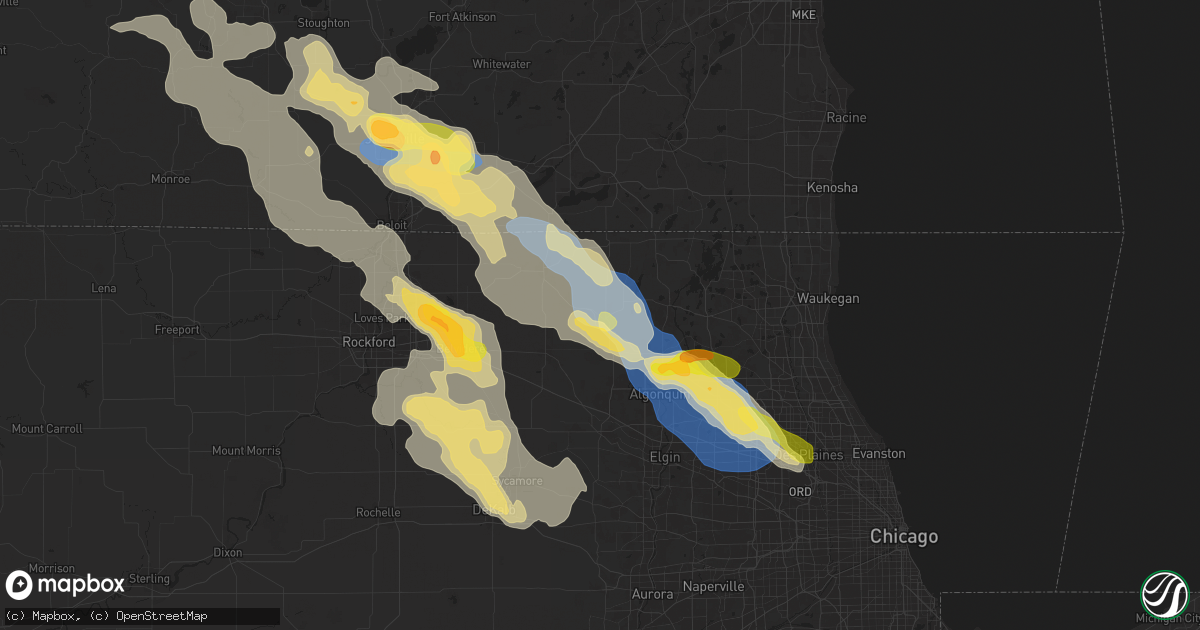
Hail Map in Woodstock, IL on August 16, 2025
Get this storm
August 16 map
$229
one time, instant access
Download today. No call, no setup
Keep the $229
Bought the map and want the full workflow? Apply the entire $229 to a subscription within 7 days. None of it is wasted.
Every map, not just this one
This buys you this map. Subscription and you get every map we run, in the markets you choose from a few cities to whole states to nationwide. Plus real-time alerts the moment a storm fires.
Contact data
Name, contact info, occupancy, even credit band for addresses in the footprint. You go from where it hit to who to call.
Become the source they trust
Unlimited branding weather history reports on demand. You already have the documented answer ready for the property owner, and you are the one who showed up with it.
Property data and RoofTrace estimates
Pull up any address you have got, its value and the exact code rules for that jurisdiction, straight from One Click Code. Then RoofTrace estimates the squares, pitch, and roof value, priced the way you price.
Storm reports in Woodstock, IL
Woodstock, IL
| Date | Description |
|---|---|
| 08/16/20253:51 PM CDT | Relayed via mping. |
| 08/16/20253:45 PM CDT | Woodstock police department reports multiple power lines downed in woodstock. Relayed by mchenry county ema. Time estimated by radar. |
| 08/16/20253:40 PM CDT | Tree on a house along clay street in woodstock. Time estimated by radar. |
All States Impacted by Hail Map on August 16, 2025
All Cities Impacted by Hail Map on August 16, 2025
- Breckenridge, MN
- Good Thunder, MN
- Saint Paul, MN
- Rosemount, MN
- Maiden Rock, WI
- Plum City, WI
- Stockholm, WI
- Onaway, MI
- Foxhome, MN
- Alma, WI
- Arkansaw, WI
- Arcadia, WI
- Greenwood, WI
- Strum, WI
- Blair, WI
- Vesper, WI
- Arpin, WI
- Unity, WI
- Colby, WI
- Spencer, WI
- Loyal, WI
- Ettrick, WI
- Gould City, MI
- Taylor, WI
- Milladore, WI
- Junction City, WI
- Abbotsford, WI
- Tigerton, WI
- Pittsville, WI
- Granton, WI
- Wisconsin Rapids, WI
- Rudolph, WI
- Stevens Point, WI
- Neillsville, WI
- Chili, WI
- Hixton, WI
- Black River Falls, WI
- Plover, WI
- Bancroft, WI
- Plainfield, WI
- Warrens, WI
- Babcock, WI
- Greentown, IN
- Nekoosa, WI
- Necedah, WI
- Wautoma, WI
- Wild Rose, WI
- Almond, WI
- Mauston, WI
- Elroy, WI
- Camp Douglas, WI
- Kendall, WI
- New Lisbon, WI
- Oxford, WI
- Markesan, WI
- Princeton, WI
- Wisconsin Dells, WI
- Montello, WI
- Dalton, WI
- Pardeeville, WI
- Tomah, WI
- Lyndon Station, WI
- Cambria, WI
- Sparta, WI
- Beaver Dam, WI
- Independence, WI
- Whitehall, WI
- Hancock, WI
- Hillpoint, WI
- Plain, WI
- Lone Rock, WI
- Fox Lake, WI
- Deforest, WI
- Rio, WI
- Spring Green, WI
- Woodbine, GA
- Gaylord, MI
- Spring, TX
- Conroe, TX
- Sauk City, WI
- Prairie Du Sac, WI
- Sun Prairie, WI
- Columbus, WI
- Harbor Beach, MI
- Mazomanie, WI
- Cochrane, WI
- Fountain City, WI
- Waterloo, WI
- Marshall, WI
- Middleton, WI
- Decker, MI
- Arena, WI
- Blue Mounds, WI
- Black Earth, WI
- Dane, WI
- Cross Plains, WI
- Wabasha, MN
- Kellogg, MN
- Arlington, WI
- Barneveld, WI
- Mccordsville, IN
- Waunakee, WI
- Windsor, WI
- Snover, MI
- Greenfield, IN
- Melrose, WI
- Mount Horeb, WI
- Madison, WI
- Brooklyn, WI
- Oregon, WI
- Belleville, WI
- Mcfarland, WI
- Savannah, GA
- Verona, WI
- Stoughton, WI
- Evansville, WI
- Convoy, OH
- Van Wert, OH
- Iowa, LA
- Edgerton, WI
- Janesville, WI
- Lake Charles, LA
- New Glarus, WI
- Fountaintown, IN
- Milton, WI
- Monticello, WI
- Avalon, WI
- Clinton, WI
- Hustler, WI
- Beloit, WI
- Albany, WI
- Darien, WI
- Bangor, WI
- Mindoro, WI
- Brighton, MI
- Howell, MI
- Shelbyville, IN
- Waldron, IN
- Wilton, WI
- Brodhead, WI
- Monroe, WI
- Whitewater, WI
- Sharon, WI
- Capron, IL
- Poplar Grove, IL
- Adams, WI
- Friendship, WI
- Grand Marsh, WI
- Harvard, IL
- Orfordville, WI
- Norwalk, WI
- Bismarck, IL
- Danville, IL
- Fowlerville, MI
- Westlake, LA
- Vinton, LA
- Arkdale, WI
- Delavan, WI
- Walworth, WI
- Coloma, WI
- Westfield, WI
- Neshkoro, WI
- Merryville, LA
- Rockton, IL
- Durand, IL
- Paint Lick, KY
- Berkeley Springs, WV
- West Lebanon, IN
- Alvin, IL
- Williamsport, IN
- Rockford, IL
- Roscoe, IL
- Loves Park, IL
- Machesney Park, IL
- Garden Prairie, IL
- South Beloit, IL
- Woodstock, IL
- Hebron, IL
- Caledonia, IL
- Belvidere, IL
- Wonder Lake, IL
- Berlin, WI
- Florissant, MO
- Saint Louis, MO
- Marengo, IL
- Flat Rock, IN
- Portage, WI
- Winfield, MO
- Starks, LA
- East Alton, IL
- Alton, IL
- Wood River, IL
- Endeavor, WI
- Briggsville, WI
- Packwaukee, WI
- Green Lake, WI
- Fontana, WI
- Baraboo, WI
- Marquette, WI
- Ripon, WI
- Poynette, WI
- Kingston, WI
- Crystal Lake, IL
- Lake In The Hills, IL
- Mchenry, IL
- Algonquin, IL
- Wyocena, WI
- Randolph, WI
- Waupun, WI
- Brandon, WI
- Fairwater, WI
- Friesland, WI
- Fall River, WI
- Orange, TX
- Buna, TX
- Cottage Hills, IL
- Blue Ridge, GA
- McCaysville, GA
- Cherry Valley, IL
- Hopkins, MI
- Allegan, MI
- Union, IL
- Lake Geneva, WI
- Dundee, IL
- Cary, IL
- Carpentersville, IL
- Barrington, IL
- Doylestown, WI
- Fox River Grove, IL
- Wauconda, IL
- Monroe Center, IL
- Kirkland, IL
- Live Oak, FL
- Elizabethtown, IN
- Watersmeet, MI
- Granite City, IL
- Owen, WI
- Footville, WI
- Afton, WI
- Huntley, IL
- Davis Junction, IL
- Lake Zurich, IL
- Elgin, IL
- Hoffman Estates, IL
- Streamwood, IL
- Kingston, IL
- Sycamore, IL
- Reeseville, WI
- Burnett, WI
- Lowell, WI
- Juneau, WI
- Watertown, WI
- Horicon, WI
- Mayville, WI
- Iron Ridge, WI
- Clyman, WI
- Hustisford, WI
- Neosho, WI
- Palatine, IL
- Milan, MI
- Columbus, IN
- Biloxi, MS
- Dexter, MI
- Wright City, MO
- Lee, FL
- Gilberts, IL
- Foristell, MO
- Esmond, IL
- Genoa, IL
- Roxana, IL
- Hartford, IL
- Clare, IL
- Lindenwood, IL
- Schaumburg, IL
- Hanover Park, IL
- Rolling Meadows, IL
- Cortland, IL
- Maple Park, IL
- Hampshire, IL
- Saint Charles, IL
- Signal Mountain, TN
- Hastings, MI
- Lake Odessa, MI
- Ann Arbor, MI
- Hoyleton, IL
- Freeport, MI
- Middleville, MI
- Dekalb, IL
- Alto, MI
- Clarksville, MI
- Wesley Chapel, FL
- San Antonio, FL
- Elk Grove Village, IL
- Mount Prospect, IL
- Arlington Heights, IL
- Rubicon, WI
- Lebanon, WI
- Des Plaines, IL
- Cayuga, IN
- Perrysville, IN
- Elburn, IL
- Lake Station, IN
- Gary, IN
- Saline, MI
- Ypsilanti, MI
- Malta, IL
- Sugar Grove, IL
- Batavia, IL
- Aurora, IL
- North Aurora, IL
- Montgomery, IL
- Mooseheart, IL
- Woodridge, IL
- Downers Grove, IL
- Lisle, IL
- Dade City, FL
- Naperville, IL
- Shabbona, IL
- Lee, IL
- Archer, FL
- Park Ridge, IL
- Clinton, MI
- Oswego, IL
- Eaton Rapids, MI
- Waterman, IL
- Rossville, IL
- Potomac, IL
- Gulfport, MS
- Dana, IN
- Jonesburg, MO
- Dahlonega, GA
- Plainfield, IL
- Bolingbrook, IL
- Romeoville, IL
- Joliet, IL
- Lockport, IL
- Crest Hill, IL
- Darien, IL
- Lemont, IL
- Jasper, TX
- Adel, GA
- Zephyrhills, FL
- Ridge Farm, IL
- Tecumseh, MI
- Muncie, IL
- Fithian, IL
- Ellijay, GA
- Homer Glen, IL
- Plant City, FL
- Channahon, IL
- Elwood, IL
- New Lenox, IL
- Mokena, IL
- Wilmington, IL
- Manhattan, IL
- Frankfort, IL
- Pall Mall, TN
- Robbins, TN
- Saint Joseph, IL
- Paron, AR
- Lufkin, TX
- Cleveland, GA
- Oakwood, IL
- Jefferson, WI
- Lake Mills, WI
- Johnson Creek, WI
- Rochester, IN
- Monterey, IN
- Culver, IN
- Henning, IL
- Perkinston, MS
- Monee, IL
- Peotone, IL
- Manteno, IL
- Pine Ridge, SD
- Rushville, NE
- Batesland, SD
- Sanford, FL
- Coal City, IL
- Allardt, TN
- Jamestown, TN
- Ogden, IL
- Valparaiso, IN
- Hobart, IN
- Crown Point, IN
- Columbia City, IN
- Grant Park, IL
- Fairmount, IL
- Homer, IL
- Shullsburg, WI
- Apple River, IL
- Maybee, MI
- Westville, IL
- West Chicago, IL
- Richton Park, IL
- University Park, IL
- Matteson, IL
- Lake Mary, FL
- Collison, IL
- Georgetown, IL
- Ingleside, IL
- Crete, IL
- Rensselaer, IN
- Dubuque, IA
- Cairo, GA
- Warren, IL
- Park Forest, IL
- Lake Village, IN
- Hay Springs, NE
- Nelson, WI
- Holy Cross, IA
- North Buena Vista, IA
- Logansport, IN
- Potosi, WI
- Cuba City, WI
- Fort Wayne, IN
- Round Lake, IL
- Royal Center, IN
- Gratiot, WI
- Lena, IL
- Winslow, IL
- Chana, IL
- Oregon, IL
- Oakfield, WI
- Buffalo, IL
- Dickeyville, WI
- Poplarville, MS
- Sherrill, IA
- Guttenberg, IA
- Browntown, WI
- Rochelle, IL
- Monticello, IN
- McConnell, IL
- Akron, CO
- South Wayne, WI
- Cassville, WI
- Mount Pulaski, IL
- Idaville, IN
- Burnettsville, IN
- Glen Ellyn, IL
- Bloomingdale, IL
- Lombard, IL
- Addison, IL
- Glendale Heights, IL
- Medinah, IL
- Roselle, IL
- Orangeville, IL
- Lavina, MT
- Platteville, WI
- Steward, IL
- Covington, IN
- Skokie, IL
- Lincolnwood, IL
- Nora, IL
- Wabash, IN
- Illiopolis, IL
- Oak Brook, IL
- Elmhurst, IL
- Villa Park, IL
- Wheaton, IL
- Frankfort, IN
- Forest, IN
- Michigantown, IN
- Gillette, WY
- Hazel Green, WI
- Camilla, GA
- Amboy, IN
- Star City, IN
- East Dubuque, IL
- Bloomington, WI
- Prairie Du Chien, WI
- Latham, IL
- Scales Mound, IL
- Galena, IL
- Carol Stream, IL
- Huntington, IN
- Havre, MT
- La Fontaine, IN
- Lancaster, WI
- Allerton, IL
- Compton, IL
- Warren, IN
- Naples, FL
- Pelham, GA
- Warrensburg, IL
- Elizabeth, IL
- Earlville, IL
- Marsland, NE
- Kirklin, IN
- Elwood, IN
- Braidwood, IL
- Momence, IL
- Stockton, IL
- Onarga, IL
- Fairmount, IN
- Sheridan, IN
- Summitville, IN
- Noblesville, IN
- Westfield, IN
- Carmel, IN
- Cicero, IN
- West Lafayette, IN
- Lafayette, IN
- Buck Creek, IN
- Battle Ground, IN
- Dayton, IN
- Rossville, IN
- Mulberry, IN
- Delphi, IN
- Colfax, IN
- Lebanon, IN
- Thorntown, IN
- Knox, IN
- Plymouth, IN
- Alexandria, IN
- Reddick, IL
- Essex, IL
- Fort Atkinson, WI
- Piper City, IL
- Chatsworth, IL
- Kieler, WI
- Arcadia, IN
- Indianapolis, IN
- Fishers, IN
- Hermosa, SD
- Helenville, WI
- Hartford City, IN
- Cornell, IL
- Murphy, ID
- Whitestown, IN
- Sunbright, TN
- Zionsville, IN
- Odell, IL
- Union Grove, WI
- Roberts, IL
- Pontiac, IL
- Flanagan, IL
- Graymont, IL
- Cissna Park, IL
- Sullivan, WI
- Portland, IN
- Ridgeville, IN
- Mount Carroll, IL
- Dunkirk, IN
- Kenosha, WI
- Kewanna, IN
- Lansing, IA
- Avon, IN
- Brownsburg, IN
- Rankin, IL
- Buckley, IL
- Saunemin, IL
- Fortville, IN
- Bartlett, IL
- South Elgin, IL
- Wayne, IL
- Itasca, IL
- Bensenville, IL
- Wood Dale, IL
- Plainfield, IN
- Chenoa, IL
- Fairbury, IL
- Forrest, IL
- Chinook, MT
- De Soto, WI
- Upton, WY
- Strawn, IL
- Hoopeston, IL
- Benton, WI
- Newcastle, WY
- Sibley, IL
- Harpers Ferry, IA
- Melvin, IL
- Cropsey, IL
- Colfax, IL
- Belle Fourche, SD
- Alzada, MT
- Avoca, WI
- Paxton, IL
- Loda, IL
- Eastman, WI
- Decorah, IA
- Dorchester, IA
- Muscoda, WI
- Lloyd, MT
- Anchor, IL
- Ludlow, IL
- Waterford, WI
- Big Bend, WI
- Waukon, IA
- Waterville, IA
- Osage, WY
- Antioch, IL
- Burlington, WI
- Steuben, WI
- Wauzeka, WI
- Beulah, WY
- Pleasant Prairie, WI
- Lake Villa, IL
- Gotham, WI
- Wilmette, IL
- Kenilworth, IL
- Trevor, WI
- Salem, WI
- Bristol, WI
- Buffalo, SD
- Freeport, IL
- Grayslake, IL
- Gurnee, IL
- Wadsworth, IL
- Waukegan, IL
- Faith, SD
- Hays, MT
- Catlin, IL
- Libertyville, IL
- Mundelein, IL
- Spearfish, SD
- Buffalo Grove, IL
- Lincolnshire, IL
- Broadlands, IL
- Highland, WI
- Scranton, ND
- Ludlow, SD
- Vernon Hills, IL
- Mud Butte, SD
- Cottage Grove, WI
- Camargo, IL
- Newman, IL
- Winfield, IL
- Winnetka, IL
- Darlington, WI
- Newell, SD
- Indianola, IL
- Niles, IL
- Morton Grove, IL
- Glenview, IL
- Lead, SD
- Golf, IL
- Evanston, IL
- Hume, IL
- Oakland, IL
- Fennimore, WI
- Mount Hope, WI
- Hill City, SD
- Woodman, WI
- East Chicago, IN
- Hammond, IN
- Monona, IA
- Saint Onge, SD
- Chrisman, IL
- Belt, MT
- Great Falls, MT
- Harmony, MN
- Preston, MN
- Paris, IL
- Mabel, MN
- Canton, MN
- Whitewood, SD
- McGregor, IA
- Melrose Park, IL
- Burlington, IL
- Vermilion, IL
- Elmwood Park, IL
- Chicago, IL
- Lanesboro, MN
- Cresco, IA
- Deadwood, SD
- Sturgis, SD
- Reva, SD
- Western Springs, IL
- Westchester, IL
- La Grange Park, IL
- Whiting, IN
- West Terre Haute, IN
- Bellwood, IL
- Berkeley, IL
- Riverside, IL
- Hines, IL
- Hillside, IL
- River Forest, IL
- Forest Park, IL
- Stone Park, IL
- Maywood, IL
- Broadview, IL
- Dennison, IL
- Balaton, MN
- Merrillville, IN
- Springfield, MN
- Sanborn, MN
- La Grange, IL
- Summit Argo, IL
- Brookfield, IL
- Lyons, IL
- Lamberton, MN
- Terre Haute, IN
- Bagley, WI
- Willow Springs, IL
- Willowbrook, IL
- Chicago Heights, IL
- Glenwood, IL
- Waseca, MN
- Fort Meade, SD
- Eagle Butte, SD
- Union Center, SD
- Lowell, IN
- Beecher, IL
- Alsip, IL
- Tinley Park, IL
- Country Club Hills, IL
- Oak Forest, IL
- Orland Park, IL
- Russell, MN
- Isabel, SD
- Enning, SD
- Meadow, SD
- River Grove, IL
- Franklin Park, IL
- Westmont, IL
- Lynd, MN
- Steger, IL
- Dupree, SD
- Janesville, MN
- Glen Haven, WI
- Ellendale, MN
- New Richland, MN
- McIntosh, SD
- Ivanhoe, MN
- Eagle Lake, MN
- Keldron, SD
- Clarendon Hills, IL
- Watauga, SD
- Morristown, SD
- Portage, IN
- Mankato, MN
- Warrenville, IL
- Minneota, MN
- Wasco, IL
- Geneva, IL
- Hinsdale, IL
- Lantry, SD
- Chesterton, IN
- Ridgeway, IA
- Hickory Hills, IL
- Bridgeview, IL
- Oak Lawn, IL
- Burbank, IL
- Chicago Ridge, IL
- Palos Park, IL
- Worth, IL
- Berwyn, IL
- Justice, IL
- Palos Hills, IL
- Timber Lake, SD
- McLaughlin, SD
- Marshall, MN
- Tracy, MN
- Slayton, MN
- Garvin, MN
- Midlothian, IL
- Markham, IL
- Palos Heights, IL
- Schneider, IN
- Cedar Lake, IN
- Shelby, IN
- Hebron, IN
- Ridgeview, SD
- Whitehorse, SD
- Dexter, MN
- Grand Meadow, MN
- Walnut Grove, MN
- Hazel Crest, IL
- Arco, MN
- Tyler, MN
- Elkton, MN
- Bristol, IL
- Big Rock, IL
- Glencross, SD
- Trail City, SD
- Selfridge, ND
- Saint John, IN
- Dyer, IN
- Morocco, IN
- Demotte, IN
- Thayer, IN
- Pembroke Township, IL
- Beaverville, IL
- Fair Oaks, IN
- Minooka, IL
- Shorewood, IL
- Yorkville, IL
- Little Eagle, SD
- Wakpala, SD
- Gettysburg, SD
- Plano, IL
- Mount Ayr, IN
- Kentland, IN
- Brook, IN
- Mobridge, SD
- Brandt, SD
- Goodland, IN
- Earl Park, IN
- Wolcott, IN
- Remington, IN
- Fowler, IN
- Pollock, SD
- Glenham, SD
- Mound City, SD
- Selby, SD
- Herreid, SD
- Fort Yates, ND
- Shields, ND
- Akaska, SD
- Strasburg, ND
- Linton, ND
- Hoven, SD
- Java, SD
- Solen, ND
- Canby, MN
- Bowdle, SD
- Eureka, SD
- Hague, ND
- Milesville, SD
- Midland, SD
- Ransom, IL
- Streator, IL
- Porter, MN
- Zeeland, ND
- Roscoe, SD
- Hosmer, SD
- Hazelton, ND
- Kinsman, IL
- Blackstone, IL
- Braddock, ND
- Moffit, ND
- Long Lake, SD
- Ashley, ND
- Tolstoy, SD
- Dwight, IL
- Leola, SD
- Lake City, PA
- Onaka, SD
- Ipswich, SD
- Kingman, IN
- Cresbard, SD
- Frederick, SD
- Westport, SD
- Granada, MN
- Blue Earth, MN
- Fairmont, MN
- Winnebago, MN


