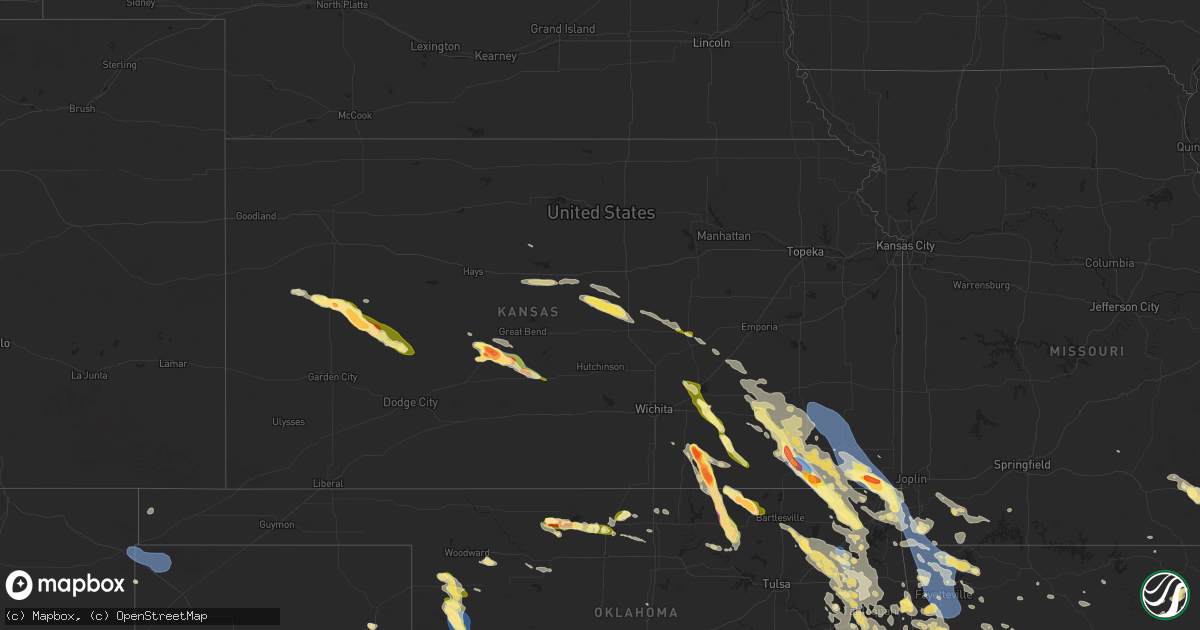
Hail Map in Kansas on August 16, 2024
Get this storm
August 16 map
$229
one time, instant access
Download today. No call, no setup
Keep the $229
Bought the map and want the full workflow? Apply the entire $229 to a subscription within 7 days. None of it is wasted.
Every map, not just this one
This buys you this map. Subscription and you get every map we run, in the markets you choose from a few cities to whole states to nationwide. Plus real-time alerts the moment a storm fires.
Contact data
Name, contact info, occupancy, even credit band for addresses in the footprint. You go from where it hit to who to call.
Become the source they trust
Unlimited branding weather history reports on demand. You already have the documented answer ready for the property owner, and you are the one who showed up with it.
Property data and RoofTrace estimates
Pull up any address you have got, its value and the exact code rules for that jurisdiction, straight from One Click Code. Then RoofTrace estimates the squares, pitch, and roof value, priced the way you price.
Storm reports in Kansas
Kansas
| Date | Description |
|---|---|
| 08/16/20246:54 PM CDT | Measured wind gust from home weather observing station. |
| 08/16/20246:30 PM CDT | Barn blown down. |
| 08/16/20246:30 PM CDT | Several metal buildings and barns damaged or destroyed across the southwestern portions of cherokee county. |
| 08/16/20246:10 PM CDT | A local report indicates 60 MPH wind near Chanute |
| 08/16/20246:03 PM CDT | A local report indicates 63 MPH wind near Chanute Martin Airport |
| 08/16/20244:54 PM CDT | Relayed by emergency management. |
| 08/16/202411:10 AM CDT | A local report indicates 1.00 inch wind near Saint John |
| 08/16/202410:47 AM CDT | A local report indicates 1.00 inch wind near 5 S Radium |
| 08/16/202410:35 AM CDT | A local report indicates 2.75 inch wind near Larned |
| 08/16/202410:32 AM CDT | Report from mping: golf ball |
| 08/16/202410:25 AM CDT | A local report indicates 72 MPH wind near Larned |
| 08/16/202410:25 AM CDT | A local report indicates 1.50 inch wind near Larned |
| 08/16/202410:25 AM CDT | Report from mping: quarter |
| 08/16/202410:10 AM CDT | A local report indicates 1.75 inch wind near 3 SSE Amy |
| 08/16/202410:03 AM CDT | A local report indicates 1.50 inch wind near 2 S Manning |
| 08/16/20249:29 AM CDT | A local report indicates 1.75 inch wind near 6 S Scott State Lake |
| 08/16/20241:10 AM CDT | Received via social media. Time and location estimated from radar. |
| 08/15/20248:27 PM CDT | 6 x 8 shed rolled along with metal roof peeled off another shed. In addition... Numerous large tree branches down. Report came in via social media and time estimated by |
| 08/15/20248:26 PM CDT | A local report indicates 1.00 inch wind near 1 E Coffeyville |
| 08/15/20248:14 PM CDT | A local report indicates 80 MPH wind near 2 S Independence |
| 08/15/20248:11 PM CDT | Reported trees and power lines down in town. |
| 08/15/20248:08 PM CDT | Also had estimated winds to 70 mph with large trees over the roadway. |
| 08/15/20248:05 PM CDT | A local report indicates 70 MPH wind near 1 W Independence |
| 08/15/20248:04 PM CDT | A local report indicates 1.00 inch wind near Leon |
| 08/15/20247:58 PM CDT | A local report indicates 2.50 inch wind near 4 SW Dexter |
| 08/15/20247:52 PM CDT | A local report indicates 1.00 inch wind near 1 N El Dorado |
| 08/15/20247:38 PM CDT | A local report indicates 1.00 inch wind near Buxton |
| 08/15/20247:37 PM CDT | Report was 1 mile southwest of winfield city lake. |
| 08/15/20247:35 PM CDT | A local report indicates 1.75 inch wind near 5 NE Melrose |
| 08/15/20247:33 PM CDT | A local report indicates 1.25 inch wind near 4 NE Winfield |
| 08/15/20247:31 PM CDT | A local report indicates 2.75 inch wind near 7 E Winfield |
| 08/15/20247:30 PM CDT | Corrects previous tstm wnd dmg report from 2 nw melrose. Several metal buildings and barns damaged or destroyed across the southwestern portions of cherokee county. |
| 08/15/20247:30 PM CDT | Portions of metal roof blown off metal building. |
| 08/15/20247:30 PM CDT | Corrects previous tstm wnd dmg report from 3 nne melrose. Barn blown down. |
| 08/15/20247:25 PM CDT | A local report indicates 80 MPH wind near 4 E Faulkner |
| 08/15/20247:22 PM CDT | A local report indicates 1.00 inch wind near 5 NE Winfield |
| 08/15/20247:15 PM CDT | A local report indicates 1.00 inch wind near Severy |
| 08/15/20247:09 PM CDT | A local report indicates 70 MPH wind near Oswego |
All States Impacted by Hail Map on August 16, 2024
Cities Impacted by Hail Map on August 16, 2024
- Cumberland, IA
- Massena, IA
- Corning, IA
- Bridgewater, IA
- Knobel, AR
- Corning, AR
- Rector, AR
- Wray, CO
- Winona, KS
- Leoti, KS
- Scott City, KS
- Healy, KS
- Dighton, KS
- Larned, KS
- Beeler, KS
- Ness City, KS
- Jetmore, KS
- Cimarron, KS
- St John, KS
- Stafford, KS
- Pittsville, WI
- Pawnee Rock, KS
- Vesper, WI
- Turon, KS
- Corbin, KY
- Woodbine, KY
- Wisconsin Rapids, WI
- Gray, KY
- Barbourville, KY
- Plover, WI
- Malvern, AR
- New London, WI
- Russell, KS
- Williamsburg, KY
- Dorrance, KS
- Bunker Hill, KS
- Wilson, KS
- Poyen, AR
- Macon, MS
- Sheridan, AR
- Amherst, WI
- Union, MS
- Ellsworth, KS
- Leola, AR
- Scandinavia, WI
- Scooba, MS
- Appleton, WI
- Kanopolis, KS
- Marquette, KS
- Carthage, AR
- Amity, AR
- Burden, KS
- Cambridge, KS
- Pattison, MS
- Hazlehurst, MS
- Geneseo, KS
- Arnett, OK
- Gage, OK
- Fargo, OK
- Louisville, MS
- Cedar Vale, KS
- Lindsborg, KS
- Toney, AL
- Athens, AL
- Kenton, OK
- Eagle River, WI
- Mcpherson, KS
- Shidler, OK
- Pawhuska, OK
- Harvest, AL
- Valier, MT
- Saint Germain, WI
- Carrollton, AL
- Sharon, OK
- Brookville, KS
- McCool, MS
- Powers, MI
- Gordo, AL
- Huntsville, AL
- Bailey, MS
- Meridian, MS
- Mendenhall, MS
- Magee, MS
- Daleville, MS
- Hermanville, MS
- Utica, MS
- Luray, KS
- Wesson, MS
- Shelby, MT
- Falun, KS
- Spalding, MI
- Vaughn, NM
- Millport, AL
- Hollytree, AL
- Princeton, AL
- Newkirk, NM
- Bartlesville, OK
- Mooreland, OK
- Woodward, OK
- Brookhaven, MS
- Eutaw, AL
- Leedey, OK
- Tuscaloosa, AL
- Gypsum, KS
- Canton, KS
- Caddo Gap, AR
- Norman, AR
- Noxapater, MS
- Durham, KS
- Hillsboro, KS
- Adger, AL
- Seminary, MS
- Banks, AR
- Ethridge, MT
- Cut Bank, MT
- Marion, KS
- Conchas Dam, NM
- West Point, MS
- Vinita, OK
- Cheyenne, OK
- Hammon, OK
- Natchez, MS
- Moundville, AL
- Rogers, AR
- Hindsville, AR
- Hampton, AR
- Collins, MS
- Scottsboro, AL
- Ocoee, TN
- Benton, TN
- Old Fort, TN
- Bessemer, AL
- Bogalusa, LA
- Franklinton, LA
- Harrell, AR
- Stevens Point, WI
- Prairie, MS
- Dutton, AL
- Glenwood, AR
- Cedar Point, KS
- Eureka, KS
- Garfield, AR
- Section, AL
- Hermitage, AR
- Corona, NM
- Forsyth, MT
- Brandon, MS
- Fyffe, AL
- Rainsville, AL
- Woodville, MS
- Duncanville, AL
- Blountville, TN
- Kingsport, TN
- Piney Flats, TN
- Bluff City, TN
- Claude, TX
- Amarillo, TX
- Quitman, MS
- Butler, AL
- Huntsville, AR
- Union Grove, AL
- Camden, MS
- Cottondale, AL
- Carthage, MS
- Langston, AL
- Canyon, TX
- Canton, MS
- Bay Springs, MS
- Linden, AL
- Newhope, AR
- Florence, KS
- Brent, AL
- Centreville, AL
- Butler, OK
- Umpire, AR
- Lena, MS
- Sylvania, AL
- Pisgah, AL
- Henagar, AL
- Matfield Green, KS
- Dacoma, OK
- Dierks, AR
- Alva, OK
- Cherokee, OK
- Volborg, MT
- Buffalo, KS
- Benedict, KS
- Yates Center, KS
- Chanute, KS
- Galesburg, KS
- Thayer, KS
- Altoona, KS
- Erie, KS
- Rio Rico, AZ
- Carmen, OK
- Somerville, AL
- Norwood, LA
- Wilmot, AR
- Vail, AZ
- Laceys Spring, AL
- Helena, OK
- Jet, OK
- Nash, OK
- Happy, TX
- Tulia, TX
- Sayre, OK
- Carter, OK
- Elk City, OK
- Lockney, TX
- Canadian, TX
- Canute, OK
- Foss, OK
- Dill City, OK
- Pond Creek, OK
- Western Grove, AR
- Arab, AL
- Winfield, KS
- Rock, KS
- Fall River, KS
- Severy, KS
- Hereford, TX
- Saint Joseph, MI
- Benton Harbor, MI
- Marshall, AR
- Jasper, AR
- Bartlett, KS
- Oswego, KS
- Columbus, KS
- Guntersville, AL
- Piedmont, AL
- Floydada, TX
- Dimmitt, TX
- Tumacacori, AZ
- Patagonia, AZ
- Green Valley, AZ
- Amado, AZ
- Sonoita, AZ
- Kremlin, OK
- Medford, OK
- Hunter, OK
- Chetopa, KS
- Howard, KS
- Sentinel, OK
- Roswell, NM
- Dexter, KS
- Vici, OK
- Fredonia, KS
- Longton, KS
- Baxter Springs, KS
- Miami, OK
- Commerce, OK
- Quapaw, OK
- Treece, KS
- Picher, OK
- Wyandotte, OK
- Saint Paul, KS
- McCune, KS
- Parsons, KS
- Altamont, KS
- Dennis, KS
- Elk City, KS
- Branson, CO
- Potwin, KS
- El Dorado, KS
- Towanda, KS
- Udall, KS
- Garber, OK
- Briscoe, TX
- Saint Francisville, LA
- Toxey, AL
- Granite, OK
- Willow, OK
- Lamont, OK
- Independence, KS
- Maple City, KS
- Anderson, MO
- Arkansas City, KS
- Seligman, MO
- Tonkawa, OK
- Fairland, OK
- Billings, OK
- Tucson, AZ
- Clinton, LA
- Lanagan, MO
- Pineville, MO
- Granby, MO
- Stark City, MO
- Pierce City, MO
- Leon, KS
- Augusta, KS
- Kim, CO
- Centreville, MS
- Grove, OK
- Cherryvale, KS
- Seneca, MO
- Liberty, KS
- Coffeyville, KS
- Latham, KS
- Nazareth, TX
- Kress, TX
- Plainview, TX
- Olton, TX
- Hale Center, TX
- Hart, TX
- Lombard, IL
- Addison, IL
- Hillside, IL
- Berkeley, IL
- Glen Ellyn, IL
- West Chicago, IL
- Melrose Park, IL
- Carol Stream, IL
- Downers Grove, IL
- Naperville, IL
- North Aurora, IL
- Westmont, IL
- Lisle, IL
- Warrenville, IL
- Aurora, IL
- Batavia, IL
- Wheaton, IL
- Oak Brook, IL
- Elmhurst, IL
- Sugar Grove, IL
- Villa Park, IL
- Glendale Heights, IL
- Geneva, IL
- Winfield, IL
- Mooseheart, IL
- Chicago, IL
- River Forest, IL
- Stone Park, IL
- Maywood, IL
- Bellwood, IL
- Oak Park, IL
- Elmwood Park, IL
- River Grove, IL
- Forest Park, IL
- Hines, IL
- Riverside, IL
- Westchester, IL
- Cicero, IL
- Broadview, IL
- Berwyn, IL
- Brookfield, IL
- La Grange Park, IL
- Lyons, IL
- Western Springs, IL
- Hinsdale, IL
- New Lenox, IL
- Joliet, IL
- Mokena, IL
- Frankfort, IL
- Matteson, IL
- Monee, IL
- Richton Park, IL
- University Park, IL
- Purdy, MO
- Fairview, MO
- Monett, MO
- Ralls, TX
- Goodman, MO
- Toronto, KS
- Virgil, KS
- Highwood, MT
- Washburn, MO
- Blackwell, OK
- Noel, MO
- Bella Vista, AR
- Bentonville, AR
- Centerton, AR
- Gravette, AR
- Sulphur Springs, AR
- Gentry, AR
- Hiwasse, AR
- Decatur, AR
- South West City, MO
- Tiff City, MO
- S Coffeyville, OK
- Lenapah, OK
- Fort Benton, MT
- Jordan, MT
- Ralston, OK
- Ponca City, OK
- Jay, OK
- Butterfield, MO
- Cassville, MO
- Wheaton, MO
- Texline, TX
- Stella, MO
- Burbank, OK
- Springdale, AR
- Cave Springs, AR
- Siloam Springs, AR
- Welch, OK
- Delaware, OK
- Fairfax, OK
- Grenola, KS
- Fayetteville, AR
- Lowell, AR
- Clayton, NM
- Cohagen, MT
- Ramona, OK
- Waynesboro, MS
- Aurora, MO
- Douglas, AZ
- East Peoria, IL
- Bluejacket, OK
- Wynona, OK
- Lorenzo, TX
- Nowata, OK
- Chelsea, OK
- Elkins, AR
- Prairie Grove, AR
- Winslow, AR
- Lincoln, AR
- Farmington, AR
- West Fork, AR
- Adair, OK
- Pryor, OK
- Dalhart, TX
- Pekin, IL
- Tremont, IL
- Morton, IL
- Groveland, IL
- Talala, OK
- Hammond, MT
- Hominy, OK
- Washington, IL
- Galena, MO
- Richton, MS
- Ovett, MS
- Bloomington, IL
- Towanda, IL
- Normal, IL
- Ellsworth, IL
- Le Roy, IL
- Downs, IL
- Heyworth, IL
- Oologah, OK
- Claremore, OK
- Colstrip, MT
- Broadus, MT
- Otter, MT
- Salina, OK
- Pea Ridge, AR
- Spavinaw, OK
- Alzada, MT
- Newkirk, OK
- Wesley, AR
- Proctor, OK
- Stilwell, OK
- Westville, OK
- Harrison, AR
- Pearce, AZ
- Cochise, AZ
- Benson, AZ
- Dragoon, AZ
- Saint David, AZ
- Capitol, MT
- Sand Springs, MT
- Saint Paul, AR
- Pettigrew, AR
- Sedan, NM
- Galata, MT
- Tahlequah, OK
- Hulbert, OK
- Farwell, TX
- Inola, OK
- Nogales, AZ
- Welling, OK
- Chouteau, OK
- Afton, OK
- Park Hill, OK
- Bunch, OK
- Cookson, OK
- Mountainburg, AR
- Chester, AR
- Buffalo, SD
- Armington, IL
- McLean, IL
- Atlanta, IL
- Deer, AR
- Ozone, AR
- Oark, AR
- Fairview, OK
- Sallisaw, OK
- Natural Dam, AR
- Canehill, AR
- Rudy, AR
- Chester, MT
- Mountain Home, AR
- Van Buren, AR
- Clarksville, AR
- Cedarville, AR
- Alma, AR
- Neodesha, KS
- Ozark, AR
- Mulberry, AR
- Yellville, AR
- Tubac, AZ
- Uniontown, AR
- Kevin, MT
- Summersville, MO
- Eminence, MO
- Lavaca, AR
- Dyer, AR
- West Plains, MO
- Fort Smith, AR
- Norfork, AR
- Altus, AR
- Ratcliff, AR
- Branch, AR
- Paris, AR
- Sturkie, AR
- Salem, AR
- Charleston, AR
- Coal Hill, AR
- Roland, OK
- Muldrow, OK
- Cecil, AR
- Magazine, AR
- Huntington, AR
- Barling, AR
- Mansfield, AR
- Greenwood, AR
- Arkoma, OK
- Booneville, AR
- Hackett, AR
- Pocola, OK
- Demotte, IN
- Wheatfield, IN
- Birch Tree, MO
- Des Moines, NM
- Dardanelle, AR
- Evening Shade, AR
- Winona, MO
- Belleville, AR
- Batesville, AR
- Sidney, AR
- Mount Pleasant, AR
- Mound Valley, KS
- Huggins, MO
- Graff, MO
- Floral, AR
- Great Bend, KS
- Cave City, AR
- Mulvane, KS
- Alton, MO
- Hudson, KS
- Poughkeepsie, AR
- Enid, OK
- Lafe, AR
- Van Buren, MO
- Fremont, MO
- Sedan, KS
- Cabool, MO
- Locust Grove, OK
- Summers, AR
- Marmaduke, AR
- Doniphan, MO
- Rose, OK
- Edna, KS
- Watts, OK
- Peggs, OK
- Piedmont, KS
- Fort Gibson, OK
- Grandin, MO
- Neelyville, MO
- Naylor, MO
- Couch, MO
- Evansville, AR
- Hamilton, KS
- Strang, OK
- Big Cabin, OK
- Oxly, MO
- Shelbyville, IL
- Newport, AR
- Cash, AR
- Union City, OK
- Piggott, AR
- Harviell, MO
- Gatewood, MO
- Warm Springs, AR
- Trumann, AR
- El Reno, OK
- Pollard, AR
- Success, AR
- Tuttle, OK
- Kennett, MO
- Senath, MO
- Vian, OK
- Tyronza, AR
- Earle, AR
- Greenway, AR
- Holcomb, MO
- Hornersville, MO
- Qulin, MO
- Gilmore, AR
- Turrell, AR
- Crawfordsville, AR
- Paragould, AR
- Joiner, AR
- Wagoner, OK
- Gobler, MO
- Fairdealing, MO
- Proctor, AR
- Steele, MO
- Blytheville, AR
- Gans, OK
- Eucha, OK
- Kansas, OK
- West Memphis, AR
- Marion, AR
- Covington, TN
- Finley, TN
- Halls, TN
- Cameron, OK
- Gore, OK
- Brighton, TN
- Caruthersville, MO
- Cooter, MO
- Ripley, TN
- Oaks, OK
- Porter, OK
- Muskogee, OK
- Stanton, TN
- Braggs, OK
- Gates, TN
- Friendship, TN
- Keota, OK
- Dyersburg, TN
- Spiro, OK
- Jackson, TN
- Humboldt, TN
- Mccurtain, OK
- Oakfield, TN
- Ketchum, OK
- Shady Point, OK
- Bokoshe, OK
- Farmer City, IL
- Lakewood, IL
- Stigler, OK
- Twin Oaks, OK
- Wister, OK
- Poteau, OK
- Scammon, KS
- Red Oak, OK
- Heavener, OK
- Howe, OK
- Hodgen, OK
- Ochelata, OK
- Guthrie, OK
- De Kalb, MS


