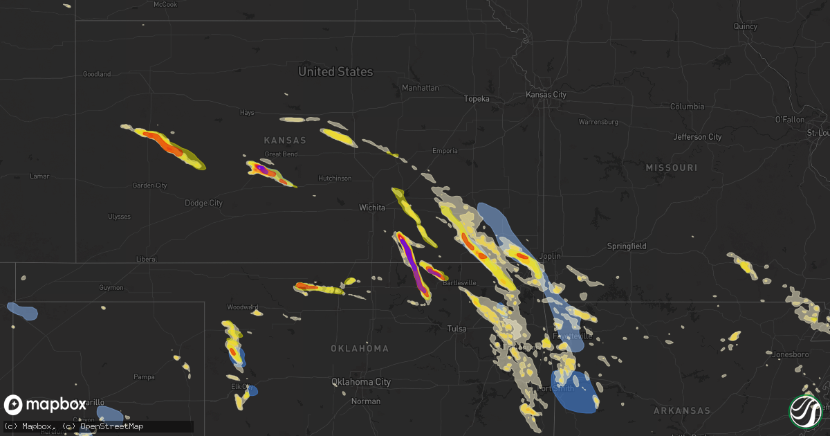
Hail Map on August 16, 2024
Get this storm
August 16 map
$229
one time, instant access
Download today. No call, no setup
Keep the $229
Bought the map and want the full workflow? Apply the entire $229 to a subscription within 7 days. None of it is wasted.
Every map, not just this one
This buys you this map. Subscription and you get every map we run, in the markets you choose from a few cities to whole states to nationwide. Plus real-time alerts the moment a storm fires.
Contact data
Name, contact info, occupancy, even credit band for addresses in the footprint. You go from where it hit to who to call.
Become the source they trust
Unlimited branding weather history reports on demand. You already have the documented answer ready for the property owner, and you are the one who showed up with it.
Property data and RoofTrace estimates
Pull up any address you have got, its value and the exact code rules for that jurisdiction, straight from One Click Code. Then RoofTrace estimates the squares, pitch, and roof value, priced the way you price.
States Impacted by Hail Map on August 16, 2024
Storm reports
Tennessee
| Date | Description |
|---|---|
| 08/16/20245:33 PM CDT | Half dozen trees down and estimated 65 mph winds. |
| 08/16/20245:09 PM CDT | A local report indicates 59 MPH wind near Tri-City Airport |
| 08/16/20244:50 PM CDT | Trees and powerlines down with 4...400 power outages across the county. |
| 08/16/20244:20 PM CDT | Multiple reports of trees down via dispatch. |
| 08/16/20244:00 PM CDT | Numerous trees and powerlines down with just under 1...400 power outages in roane county. |
| 08/16/20243:55 PM CDT | Numerous trees and powerlines down with over 1...300 power outages/nearly 270f tracked customers out. |
| 08/16/20243:48 AM CDT | Report of a tree fallen onto a home in maury city. |
| 08/16/20243:22 AM CDT | Several large tree limbs downed in the gift community. |
| 08/16/20243:15 AM CDT | Large tree blown down onto a vehicle in newbern. |
North Carolina
| Date | Description |
|---|---|
| 08/16/20246:52 PM CDT | Tree down 1900 block old fort sugar hill rd. |
| 08/16/20246:50 PM CDT | Tree down in 3200 block of hankins rd. |
| 08/16/20246:45 PM CDT | Tree down on deep ford road. Time estimated from radar. |
| 08/16/20246:38 PM CDT | 911 communications reported multiple trees down with one blocking roadway on rodeo drive. |
| 08/16/20246:36 PM CDT | Multiple reports of trees blown down along rosman hwy between rosman and brevard. Time estimated by radar. |
| 08/16/20246:21 PM CDT | Trees and power lines down on beaver creek rd. Times estimated from radar. |
| 08/16/20246:21 PM CDT | Tree down on little laurel road. Time estimated from radar. |
| 08/16/20246:10 PM CDT | Trees and power lines down on lucy morgan ln. Radar estimated time. |
| 08/16/20245:54 PM CDT | Report from mping: 1-inch tree limbs broken; shingles blown off. |
| 08/16/20245:52 PM CDT | Trees and power lines down around waynesville. |
| 08/16/20245:42 PM CDT | Trees down. |
| 08/16/20245:35 PM CDT | Trees down on sweetwater rd. |
| 08/15/20247:40 PM CDT | 911 communications reported multiple trees down in the forest city and sandy mush area. Some blocking roadways. |
| 08/15/20247:15 PM CDT | Scattered reports of tree limbs down across the county. |
Louisiana
| Date | Description |
|---|---|
| 08/16/20245:15 PM CDT | Delayed report of tree down on thigpen creek rd. Time estimated by radar. |
| 08/16/20245:10 PM CDT | Delayed report of tree down on south choctaw rd. |
Missouri
| Date | Description |
|---|---|
| 08/16/20243:05 AM CDT | A tree downed a powerline on willow and s ward. |
| 08/16/20243:01 AM CDT | Powerline down on state hwy dd. Time radar estimated. |
| 08/16/20242:29 AM CDT | Tree down on state hwy 164 near steele. |
| 08/15/202410:05 PM CDT | Two inch tree limbs reported to have been downed. |
| 08/15/20249:00 PM CDT | Tree limbs reported to be downed. |
| 08/15/20248:50 PM CDT | Trees down on a home. |
| 08/15/20248:50 PM CDT | Trees reported to be downed in the eagle rock and shell knob areas. |
| 08/15/20248:45 PM CDT | Trees down on road. |
| 08/15/20248:35 PM CDT | Tree limbs down. |
| 08/15/20248:22 PM CDT | Trees and power lines reported to have been downed. Time estimated by radar. |
| 08/15/20248:20 PM CDT | Tree down across road. |
| 08/15/20248:15 PM CDT | Wall of metal building collapsed. |
| 08/15/20248:10 PM CDT | Tree limbs reported downed over the road. |
| 08/15/20248:00 PM CDT | A local report indicates 70 MPH wind near 1 NNE Seneca |
| 08/15/20248:00 PM CDT | Large tree uprooted. |
Indiana
| Date | Description |
|---|---|
| 08/15/20249:28 PM CDT | Photo shared on social media showing a large tree branch downed onto a car in the demotte area. A canopy and trampoline were lofted by the winds and impaled into a hors |
Arkansas
| Date | Description |
|---|---|
| 08/16/20246:00 PM CDT | Tree downed across highway 84 near the post office in umpire. |
| 08/16/20246:00 PM CDT | Trees and power lines downed near the intersection of tollett road and bissell road. |
| 08/16/20246:00 PM CDT | Trees downed along tollett road just south of the intersection with hill loop. |
| 08/16/20246:00 PM CDT | Updating tstm wnd dmg report from 9 nne dierks. Tree downed along tollett road just south of the intersection with hill loop... Falling onto a home... Two vehicles and |
| 08/16/20244:15 PM CDT | A weather observer reported multiple trees down between bismarck and deroche especially on highway 84. There are reportedly trees on some homes as well. The observer no |
| 08/16/20243:15 PM CDT | Corrects previous tstm wnd dmg report from 3 w de roche - corrected for time. A weather observer reported multiple trees down between bismarck and deroche especially on |
| 08/16/20242:51 PM CDT | Report from mping: 1-inch tree limbs broken; shingles blown off. |
| 08/16/20242:22 AM CDT | Several trees down and large hail in the areas of clay rds 492... 473... And 475. |
| 08/16/20242:03 AM CDT | Tree down across the highway in payneway. |
| 08/16/20241:55 AM CDT | Several trees down along highway 163 north between holly springs lane and andrew lane. |
| 08/16/20241:10 AM CDT | A local report indicates 1.00 inch wind near Rector |
| 08/16/202412:51 AM CDT | Em reports multiple trees and power lines down across the county with some roads blocked. |
| 08/16/202412:48 AM CDT | Observer reports trees down across parts of hwy 88 and 270. |
| 08/16/202412:16 AM CDT | Em reports trees and power lines down across the county with some roadways blocked. |
| 08/15/202411:41 PM CDT | Franklin county em relayed a measured wind gust of 58 mph 3 miles east of booneville on highway 10. |
| 08/15/202411:30 PM CDT | Large tree down. Power lines down. |
| 08/15/202411:25 PM CDT | Limbs of 6 inch diameter down. |
| 08/15/202411:17 PM CDT | A local report indicates 60 MPH wind near Fort Smith |
| 08/15/202411:10 PM CDT | Reported extensive tree damage and trees uprooted. Damage to roofs. Measured wind gust of 85 mph. |
| 08/15/202411:10 PM CDT | Trees down on old union town road. |
| 08/15/202411:07 PM CDT | Trees down. |
| 08/15/20249:15 PM CDT | Reports of campers overturned near the beaver lake dam. Relayed by the county em. Time estimated from radar. |
| 08/15/20248:45 PM CDT | Trees down on a few homes. Relayed from social media reports. Time estimated via radar. |
| 08/15/20248:41 PM CDT | 56 knot |
Texas
| Date | Description |
|---|---|
| 08/16/20246:37 PM CDT | A local report indicates 65 MPH wind near 1 E Happy |
| 08/16/20245:27 PM CDT | A local report indicates 64 MPH wind near 10 ENE Palo Duro Canyon |
| 08/15/20248:47 PM CDT | A local report indicates 66 MPH wind near 2 N Texline |
| 08/15/20247:51 PM CDT | A local report indicates 59 MPH wind near 3 N Hart |
Illinois
| Date | Description |
|---|---|
| 08/15/20249:26 PM CDT | Estimated around 60 mph. |
| 08/15/20248:45 PM CDT | 20 ft long tree limb down on powerlines in the 2900 block of springfield rd... East peoria. |
| 08/15/20248:09 PM CDT | Measured gust to 62 mph at a private weather station. |
| 08/15/20248:02 PM CDT | Picture of a roughly 6 inches diameter tree branch down received via social media. Time estimated from radar. |
| 08/15/20247:58 PM CDT | Photo shared on social media shows a tree approximately 18 inches in diameter completely snapped off roughly 20 feet above the ground. Time estimated. |
| 08/15/20247:50 PM CDT | A tree was broken in half from the top and a fence was blown down... Far north side of joliet approximately one mile west of route 53. Relayed from social media. Time e |
| 08/15/20247:44 PM CDT | Photo shared on social media showing a large tree limb snapped and dangling from a tree in woodridge. Time estimated from radar. |
| 08/15/20247:34 PM CDT | Photo shared on social media shows a large tree limb blown down between landsdown avenue and mistflower lane. Time estimated. |
| 08/15/20247:28 PM CDT | Measured gust to 69 mph at private weather station. |
| 08/15/20247:10 PM CDT | Photos show several large tree limbs snapped... One hanging on power lines. Time estimated. |
| 08/15/20247:08 PM CDT | Flag pole snapped and tree damage observed near lake holiday. A shared video also showed an apparent gustnado over lake holiday. |
Wisconsin
| Date | Description |
|---|---|
| 08/16/20241:30 PM CDT | Few large trees snapped. On crystal river lane southwest of waupaca. Time based on radar. |
Arizona
| Date | Description |
|---|---|
| 08/16/20246:48 PM CDT | Mesonet station qhpa3 hopkins. Time estimated by radar. |
| 08/15/202410:14 PM CDT | Personal weather station estimate of 60 mph wind gust. |
Alabama
| Date | Description |
|---|---|
| 08/16/20246:09 PM CDT | Trees down near fyffe. |
| 08/16/20245:58 PM CDT | Trees and power lines down in broomtown. |
| 08/16/20245:48 PM CDT | Trees were twisted and snapped with power lines entangled on cr 329 between al highways 75 and 227. Time estimated by radar. |
| 08/16/20245:38 PM CDT | Trees down near pine ridge. |
| 08/16/20245:34 PM CDT | Trees down near cr 610 and cr 85 near the bottom of sand mountain. |
| 08/16/20245:33 PM CDT | Tree down near cr 85 in hammondville. |
| 08/16/20245:33 PM CDT | Tree down near cr 85 in hammondville. |
| 08/16/20245:20 PM CDT | Corrects previous tstm wnd dmg report from 5 s henagar. Trees down near cr 114 and cr 85 in henagar. |
| 08/16/20245:15 PM CDT | Trees down near cr 114 and cr 85 in henagar. |
Kansas
| Date | Description |
|---|---|
| 08/16/20246:54 PM CDT | Measured wind gust from home weather observing station. |
| 08/16/20246:30 PM CDT | Barn blown down. |
| 08/16/20246:30 PM CDT | Several metal buildings and barns damaged or destroyed across the southwestern portions of cherokee county. |
| 08/16/20246:10 PM CDT | A local report indicates 60 MPH wind near Chanute |
| 08/16/20246:03 PM CDT | A local report indicates 63 MPH wind near Chanute Martin Airport |
| 08/16/20244:54 PM CDT | Relayed by emergency management. |
| 08/16/202411:10 AM CDT | A local report indicates 1.00 inch wind near Saint John |
| 08/16/202410:47 AM CDT | A local report indicates 1.00 inch wind near 5 S Radium |
| 08/16/202410:35 AM CDT | A local report indicates 2.75 inch wind near Larned |
| 08/16/202410:32 AM CDT | Report from mping: golf ball |
| 08/16/202410:25 AM CDT | A local report indicates 1.50 inch wind near Larned |
| 08/16/202410:25 AM CDT | A local report indicates 72 MPH wind near Larned |
| 08/16/202410:25 AM CDT | Report from mping: quarter |
| 08/16/202410:10 AM CDT | A local report indicates 1.75 inch wind near 3 SSE Amy |
| 08/16/202410:03 AM CDT | A local report indicates 1.50 inch wind near 2 S Manning |
| 08/16/20249:29 AM CDT | A local report indicates 1.75 inch wind near 6 S Scott State Lake |
| 08/16/20241:10 AM CDT | Received via social media. Time and location estimated from radar. |
| 08/15/20248:27 PM CDT | 6 x 8 shed rolled along with metal roof peeled off another shed. In addition... Numerous large tree branches down. Report came in via social media and time estimated by |
| 08/15/20248:26 PM CDT | A local report indicates 1.00 inch wind near 1 E Coffeyville |
| 08/15/20248:14 PM CDT | A local report indicates 80 MPH wind near 2 S Independence |
| 08/15/20248:11 PM CDT | Reported trees and power lines down in town. |
| 08/15/20248:08 PM CDT | Also had estimated winds to 70 mph with large trees over the roadway. |
| 08/15/20248:05 PM CDT | A local report indicates 70 MPH wind near 1 W Independence |
| 08/15/20248:04 PM CDT | A local report indicates 1.00 inch wind near Leon |
| 08/15/20247:58 PM CDT | A local report indicates 2.50 inch wind near 4 SW Dexter |
| 08/15/20247:52 PM CDT | A local report indicates 1.00 inch wind near 1 N El Dorado |
| 08/15/20247:38 PM CDT | A local report indicates 1.00 inch wind near Buxton |
| 08/15/20247:37 PM CDT | Report was 1 mile southwest of winfield city lake. |
| 08/15/20247:35 PM CDT | A local report indicates 1.75 inch wind near 5 NE Melrose |
| 08/15/20247:33 PM CDT | A local report indicates 1.25 inch wind near 4 NE Winfield |
| 08/15/20247:31 PM CDT | A local report indicates 2.75 inch wind near 7 E Winfield |
| 08/15/20247:30 PM CDT | Corrects previous tstm wnd dmg report from 3 nne melrose. Barn blown down. |
| 08/15/20247:30 PM CDT | Portions of metal roof blown off metal building. |
| 08/15/20247:30 PM CDT | Corrects previous tstm wnd dmg report from 2 nw melrose. Several metal buildings and barns damaged or destroyed across the southwestern portions of cherokee county. |
| 08/15/20247:25 PM CDT | A local report indicates 80 MPH wind near 4 E Faulkner |
| 08/15/20247:22 PM CDT | A local report indicates 1.00 inch wind near 5 NE Winfield |
| 08/15/20247:15 PM CDT | A local report indicates 1.00 inch wind near Severy |
| 08/15/20247:09 PM CDT | A local report indicates 70 MPH wind near Oswego |
Ohio
| Date | Description |
|---|---|
| 08/16/20246:24 PM CDT | Reports of multiple trees down. |
| 08/16/20245:59 PM CDT | Picture of a power pole twisted in power lines. |
Georgia
| Date | Description |
|---|---|
| 08/16/20245:51 PM CDT | Tree across the road near the intersection of hwy 48 and eleventh ave. |
| 08/16/20245:45 PM CDT | A tree was downed across hwy 337 in front of menlo school. |
| 08/16/20244:53 AM CDT | Per local emc there was a broken and downed powerline along nugget ridge rd. |
| 08/16/20244:48 AM CDT | Per local emc there was a broken and downed powerline along mcclain mountain rd nw of marblehill georgia. |
Mississippi
| Date | Description |
|---|---|
| 08/16/20245:50 PM CDT | Trees downed in the farmhaven area... Including some blocking the road on miggins rd and pat luckett rd. |
| 08/16/20245:27 PM CDT | A large limb was downed blocking mary crapps rd. |
| 08/16/20245:15 PM CDT | A few trees were downed around covington county. |
| 08/16/20245:15 PM CDT | A portion of the roof of a clinic along the highway 49 frontage rd was blown off. Report via social media. |
| 08/16/20245:05 PM CDT | A tree was downed on a powerline along wilson cove. A large tree was downed across the road at jodie dr and holly bush rd. |
| 08/16/20244:50 PM CDT | Trees downed at springhill rd and baggett rd. Report via social media. |
| 08/16/20244:45 PM CDT | Report of trees and power lines downed on ms 145 near springhill rd and a tree downed across s anderson rd. Report via social media. |
| 08/16/20243:15 PM CDT | A tree was downed across monticello rd about 3 miles east of us highway 51. |
| 08/16/20243:10 PM CDT | A tree fell on a store in martinville. |
| 08/16/20242:45 PM CDT | Trees downed on ms hwy 15 and cr 248. |
West Virginia
| Date | Description |
|---|---|
| 08/16/20245:10 AM CDT | Tree on power line. |
Oklahoma
| Date | Description |
|---|---|
| 08/16/20246:53 PM CDT | A local report indicates 1.00 inch wind near 6 W Pond Creek |
| 08/16/20246:40 PM CDT | A local report indicates 61 MPH wind near 2 WSW Burns Flat |
| 08/16/20246:30 PM CDT | Delayed report from friday... August 16. Roof damage to a mobile home. Relayed image. Radar estimated time. |
| 08/16/20245:40 PM CDT | A local report indicates 60 MPH wind near 4 NW Hammon |
| 08/16/20244:14 PM CDT | A lot of hail up to 2 inches in size covering the ground on highway 99 north of pawhuska. |
| 08/16/20244:37 AM CDT | A local report indicates 1.00 inch wind near Braggs |
| 08/16/20243:26 AM CDT | Tree limbs and power lines down. |
| 08/16/20243:20 AM CDT | Four large trees down and power lines downed to the south of the location. Relayed by wfo norman. Time estimated. |
| 08/16/20241:30 AM CDT | Report from mping: quarter |
| 08/15/20249:03 PM CDT | Report from mping: quarter |
| 08/15/20248:00 PM CDT | Several reports of large tree limbs and power lines downed in seneca. |
| 08/15/20247:55 PM CDT | Trees down across highway 60 between wyandotte and seneca missouri. Time and exact location estimated. Report relayed via the quapaw nation marshal service facebook pag |
| 08/15/20247:40 PM CDT | Measured at the miami ok mesonet station. |
| 08/15/20247:40 PM CDT | 8 inch diameter tree limbs downed just east of miami. Relayed by off-duty nws employee. |
| 08/15/20247:35 PM CDT | Report from mping: 3-inch tree limbs broken; power poles broken. Time adjusted from original report using radar estimate. |
| 08/15/20247:35 PM CDT | Significant damage in hockerville... Including a roof to a shop blown across a road and 6 poles blown down. Relayed by the public on the quapaw nation marshals service |
| 08/15/20247:00 PM CDT | Delayed report from friday... August 16. A metal barn had its roof blown off and damage to bay doors. Relayed image. Radar estimated time. |
Cities Impacted by Hail Map on August 16, 2024
- Cumberland, IA
- Massena, IA
- Corning, IA
- Bridgewater, IA
- Knobel, AR
- Corning, AR
- Rector, AR
- Wray, CO
- Winona, KS
- Leoti, KS
- Scott City, KS
- Healy, KS
- Dighton, KS
- Larned, KS
- Beeler, KS
- Ness City, KS
- Jetmore, KS
- Cimarron, KS
- St John, KS
- Stafford, KS
- Pittsville, WI
- Pawnee Rock, KS
- Vesper, WI
- Turon, KS
- Corbin, KY
- Woodbine, KY
- Wisconsin Rapids, WI
- Gray, KY
- Barbourville, KY
- Plover, WI
- Malvern, AR
- New London, WI
- Russell, KS
- Williamsburg, KY
- Dorrance, KS
- Bunker Hill, KS
- Wilson, KS
- Poyen, AR
- Macon, MS
- Sheridan, AR
- Amherst, WI
- Union, MS
- Ellsworth, KS
- Leola, AR
- Scandinavia, WI
- Scooba, MS
- Appleton, WI
- Kanopolis, KS
- Marquette, KS
- Carthage, AR
- Amity, AR
- Burden, KS
- Cambridge, KS
- Pattison, MS
- Hazlehurst, MS
- Geneseo, KS
- Arnett, OK
- Gage, OK
- Fargo, OK
- Louisville, MS
- Cedar Vale, KS
- Lindsborg, KS
- Toney, AL
- Athens, AL
- Kenton, OK
- Eagle River, WI
- Mcpherson, KS
- Shidler, OK
- Pawhuska, OK
- Harvest, AL
- Valier, MT
- Saint Germain, WI
- Carrollton, AL
- Sharon, OK
- Brookville, KS
- McCool, MS
- Powers, MI
- Gordo, AL
- Huntsville, AL
- Bailey, MS
- Meridian, MS
- Mendenhall, MS
- Magee, MS
- Daleville, MS
- Hermanville, MS
- Utica, MS
- Luray, KS
- Wesson, MS
- Shelby, MT
- Falun, KS
- Spalding, MI
- Vaughn, NM
- Millport, AL
- Hollytree, AL
- Princeton, AL
- Newkirk, NM
- Bartlesville, OK
- Mooreland, OK
- Woodward, OK
- Brookhaven, MS
- Eutaw, AL
- Leedey, OK
- Tuscaloosa, AL
- Gypsum, KS
- Canton, KS
- Caddo Gap, AR
- Norman, AR
- Noxapater, MS
- Durham, KS
- Hillsboro, KS
- Adger, AL
- Seminary, MS
- Banks, AR
- Ethridge, MT
- Cut Bank, MT
- Marion, KS
- Conchas Dam, NM
- West Point, MS
- Vinita, OK
- Cheyenne, OK
- Hammon, OK
- Natchez, MS
- Moundville, AL
- Rogers, AR
- Hindsville, AR
- Hampton, AR
- Collins, MS
- Scottsboro, AL
- Ocoee, TN
- Benton, TN
- Old Fort, TN
- Bessemer, AL
- Bogalusa, LA
- Franklinton, LA
- Harrell, AR
- Stevens Point, WI
- Prairie, MS
- Dutton, AL
- Glenwood, AR
- Cedar Point, KS
- Eureka, KS
- Garfield, AR
- Section, AL
- Hermitage, AR
- Corona, NM
- Forsyth, MT
- Brandon, MS
- Fyffe, AL
- Rainsville, AL
- Woodville, MS
- Duncanville, AL
- Blountville, TN
- Kingsport, TN
- Piney Flats, TN
- Bluff City, TN
- Claude, TX
- Amarillo, TX
- Quitman, MS
- Butler, AL
- Huntsville, AR
- Union Grove, AL
- Camden, MS
- Cottondale, AL
- Carthage, MS
- Langston, AL
- Canyon, TX
- Canton, MS
- Bay Springs, MS
- Linden, AL
- Newhope, AR
- Florence, KS
- Brent, AL
- Centreville, AL
- Butler, OK
- Umpire, AR
- Lena, MS
- Sylvania, AL
- Pisgah, AL
- Henagar, AL
- Matfield Green, KS
- Dacoma, OK
- Dierks, AR
- Alva, OK
- Cherokee, OK
- Volborg, MT
- Buffalo, KS
- Benedict, KS
- Yates Center, KS
- Chanute, KS
- Galesburg, KS
- Thayer, KS
- Altoona, KS
- Erie, KS
- Rio Rico, AZ
- Carmen, OK
- Somerville, AL
- Norwood, LA
- Wilmot, AR
- Vail, AZ
- Laceys Spring, AL
- Helena, OK
- Jet, OK
- Nash, OK
- Happy, TX
- Tulia, TX
- Sayre, OK
- Carter, OK
- Elk City, OK
- Lockney, TX
- Canadian, TX
- Canute, OK
- Foss, OK
- Dill City, OK
- Pond Creek, OK
- Western Grove, AR
- Arab, AL
- Winfield, KS
- Rock, KS
- Fall River, KS
- Severy, KS
- Hereford, TX
- Saint Joseph, MI
- Benton Harbor, MI
- Marshall, AR
- Jasper, AR
- Bartlett, KS
- Oswego, KS
- Columbus, KS
- Guntersville, AL
- Piedmont, AL
- Floydada, TX
- Dimmitt, TX
- Tumacacori, AZ
- Patagonia, AZ
- Green Valley, AZ
- Amado, AZ
- Sonoita, AZ
- Kremlin, OK
- Medford, OK
- Hunter, OK
- Chetopa, KS
- Howard, KS
- Sentinel, OK
- Roswell, NM
- Dexter, KS
- Vici, OK
- Fredonia, KS
- Longton, KS
- Baxter Springs, KS
- Miami, OK
- Commerce, OK
- Quapaw, OK
- Treece, KS
- Picher, OK
- Wyandotte, OK
- Saint Paul, KS
- McCune, KS
- Parsons, KS
- Altamont, KS
- Dennis, KS
- Elk City, KS
- Branson, CO
- Potwin, KS
- El Dorado, KS
- Towanda, KS
- Udall, KS
- Garber, OK
- Briscoe, TX
- Saint Francisville, LA
- Toxey, AL
- Granite, OK
- Willow, OK
- Lamont, OK
- Independence, KS
- Maple City, KS
- Anderson, MO
- Arkansas City, KS
- Seligman, MO
- Tonkawa, OK
- Fairland, OK
- Billings, OK
- Tucson, AZ
- Clinton, LA
- Lanagan, MO
- Pineville, MO
- Granby, MO
- Stark City, MO
- Pierce City, MO
- Leon, KS
- Augusta, KS
- Kim, CO
- Centreville, MS
- Grove, OK
- Cherryvale, KS
- Seneca, MO
- Liberty, KS
- Coffeyville, KS
- Latham, KS
- Nazareth, TX
- Kress, TX
- Plainview, TX
- Olton, TX
- Hale Center, TX
- Hart, TX
- Lombard, IL
- Addison, IL
- Hillside, IL
- Berkeley, IL
- Glen Ellyn, IL
- West Chicago, IL
- Melrose Park, IL
- Carol Stream, IL
- Downers Grove, IL
- Naperville, IL
- North Aurora, IL
- Westmont, IL
- Lisle, IL
- Warrenville, IL
- Aurora, IL
- Batavia, IL
- Wheaton, IL
- Oak Brook, IL
- Elmhurst, IL
- Sugar Grove, IL
- Villa Park, IL
- Glendale Heights, IL
- Geneva, IL
- Winfield, IL
- Mooseheart, IL
- Chicago, IL
- River Forest, IL
- Stone Park, IL
- Maywood, IL
- Bellwood, IL
- Oak Park, IL
- Elmwood Park, IL
- River Grove, IL
- Forest Park, IL
- Hines, IL
- Riverside, IL
- Westchester, IL
- Cicero, IL
- Broadview, IL
- Berwyn, IL
- Brookfield, IL
- La Grange Park, IL
- Lyons, IL
- Western Springs, IL
- Hinsdale, IL
- New Lenox, IL
- Joliet, IL
- Mokena, IL
- Frankfort, IL
- Matteson, IL
- Monee, IL
- Richton Park, IL
- University Park, IL
- Purdy, MO
- Fairview, MO
- Monett, MO
- Ralls, TX
- Goodman, MO
- Toronto, KS
- Virgil, KS
- Highwood, MT
- Washburn, MO
- Blackwell, OK
- Noel, MO
- Bella Vista, AR
- Bentonville, AR
- Centerton, AR
- Gravette, AR
- Sulphur Springs, AR
- Gentry, AR
- Hiwasse, AR
- Decatur, AR
- South West City, MO
- Tiff City, MO
- S Coffeyville, OK
- Lenapah, OK
- Fort Benton, MT
- Jordan, MT
- Ralston, OK
- Ponca City, OK
- Jay, OK
- Butterfield, MO
- Cassville, MO
- Wheaton, MO
- Texline, TX
- Stella, MO
- Burbank, OK
- Springdale, AR
- Cave Springs, AR
- Siloam Springs, AR
- Welch, OK
- Delaware, OK
- Fairfax, OK
- Grenola, KS
- Fayetteville, AR
- Lowell, AR
- Clayton, NM
- Cohagen, MT
- Ramona, OK
- Waynesboro, MS
- Aurora, MO
- Douglas, AZ
- East Peoria, IL
- Bluejacket, OK
- Wynona, OK
- Lorenzo, TX
- Nowata, OK
- Chelsea, OK
- Elkins, AR
- Prairie Grove, AR
- Winslow, AR
- Lincoln, AR
- Farmington, AR
- West Fork, AR
- Adair, OK
- Pryor, OK
- Dalhart, TX
- Pekin, IL
- Tremont, IL
- Morton, IL
- Groveland, IL
- Talala, OK
- Hammond, MT
- Hominy, OK
- Washington, IL
- Galena, MO
- Richton, MS
- Ovett, MS
- Bloomington, IL
- Towanda, IL
- Normal, IL
- Ellsworth, IL
- Le Roy, IL
- Downs, IL
- Heyworth, IL
- Oologah, OK
- Claremore, OK
- Colstrip, MT
- Broadus, MT
- Otter, MT
- Salina, OK
- Pea Ridge, AR
- Spavinaw, OK
- Alzada, MT
- Newkirk, OK
- Wesley, AR
- Proctor, OK
- Stilwell, OK
- Westville, OK
- Harrison, AR
- Pearce, AZ
- Cochise, AZ
- Benson, AZ
- Dragoon, AZ
- Saint David, AZ
- Capitol, MT
- Sand Springs, MT
- Saint Paul, AR
- Pettigrew, AR
- Sedan, NM
- Galata, MT
- Tahlequah, OK
- Hulbert, OK
- Farwell, TX
- Inola, OK
- Nogales, AZ
- Welling, OK
- Chouteau, OK
- Afton, OK
- Park Hill, OK
- Bunch, OK
- Cookson, OK
- Mountainburg, AR
- Chester, AR
- Buffalo, SD
- Armington, IL
- McLean, IL
- Atlanta, IL
- Deer, AR
- Ozone, AR
- Oark, AR
- Fairview, OK
- Sallisaw, OK
- Natural Dam, AR
- Canehill, AR
- Rudy, AR
- Chester, MT
- Mountain Home, AR
- Van Buren, AR
- Clarksville, AR
- Cedarville, AR
- Alma, AR
- Neodesha, KS
- Ozark, AR
- Mulberry, AR
- Yellville, AR
- Tubac, AZ
- Uniontown, AR
- Kevin, MT
- Summersville, MO
- Eminence, MO
- Lavaca, AR
- Dyer, AR
- West Plains, MO
- Fort Smith, AR
- Norfork, AR
- Altus, AR
- Ratcliff, AR
- Branch, AR
- Paris, AR
- Sturkie, AR
- Salem, AR
- Charleston, AR
- Coal Hill, AR
- Roland, OK
- Muldrow, OK
- Cecil, AR
- Magazine, AR
- Huntington, AR
- Barling, AR
- Mansfield, AR
- Greenwood, AR
- Arkoma, OK
- Booneville, AR
- Hackett, AR
- Pocola, OK
- Demotte, IN
- Wheatfield, IN
- Birch Tree, MO
- Des Moines, NM
- Dardanelle, AR
- Evening Shade, AR
- Winona, MO
- Belleville, AR
- Batesville, AR
- Sidney, AR
- Mount Pleasant, AR
- Mound Valley, KS
- Huggins, MO
- Graff, MO
- Floral, AR
- Great Bend, KS
- Cave City, AR
- Mulvane, KS
- Alton, MO
- Hudson, KS
- Poughkeepsie, AR
- Enid, OK
- Lafe, AR
- Van Buren, MO
- Fremont, MO
- Sedan, KS
- Cabool, MO
- Locust Grove, OK
- Summers, AR
- Marmaduke, AR
- Doniphan, MO
- Rose, OK
- Edna, KS
- Watts, OK
- Peggs, OK
- Piedmont, KS
- Fort Gibson, OK
- Grandin, MO
- Neelyville, MO
- Naylor, MO
- Couch, MO
- Evansville, AR
- Hamilton, KS
- Strang, OK
- Big Cabin, OK
- Oxly, MO
- Shelbyville, IL
- Newport, AR
- Cash, AR
- Union City, OK
- Piggott, AR
- Harviell, MO
- Gatewood, MO
- Warm Springs, AR
- Trumann, AR
- El Reno, OK
- Pollard, AR
- Success, AR
- Tuttle, OK
- Kennett, MO
- Senath, MO
- Vian, OK
- Tyronza, AR
- Earle, AR
- Greenway, AR
- Holcomb, MO
- Hornersville, MO
- Qulin, MO
- Gilmore, AR
- Turrell, AR
- Crawfordsville, AR
- Paragould, AR
- Joiner, AR
- Wagoner, OK
- Gobler, MO
- Fairdealing, MO
- Proctor, AR
- Steele, MO
- Blytheville, AR
- Gans, OK
- Eucha, OK
- Kansas, OK
- West Memphis, AR
- Marion, AR
- Covington, TN
- Finley, TN
- Halls, TN
- Cameron, OK
- Gore, OK
- Brighton, TN
- Caruthersville, MO
- Cooter, MO
- Ripley, TN
- Oaks, OK
- Porter, OK
- Muskogee, OK
- Stanton, TN
- Braggs, OK
- Gates, TN
- Friendship, TN
- Keota, OK
- Dyersburg, TN
- Spiro, OK
- Jackson, TN
- Humboldt, TN
- Mccurtain, OK
- Oakfield, TN
- Ketchum, OK
- Shady Point, OK
- Bokoshe, OK
- Farmer City, IL
- Lakewood, IL
- Stigler, OK
- Twin Oaks, OK
- Wister, OK
- Poteau, OK
- Scammon, KS
- Red Oak, OK
- Heavener, OK
- Howe, OK
- Hodgen, OK
- Ochelata, OK
- Guthrie, OK
- De Kalb, MS