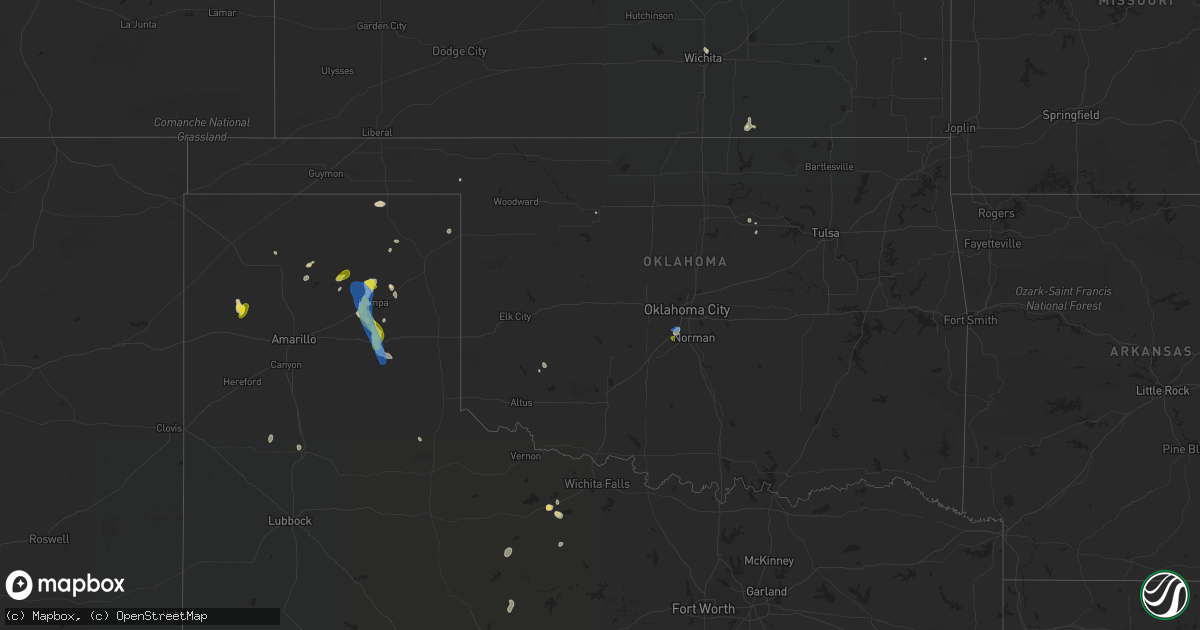
Hail Map in Oklahoma on August 16, 2021
Get this storm
August 16 map
$229
one time, instant access
Download today. No call, no setup
Keep the $229
Bought the map and want the full workflow? Apply the entire $229 to a subscription within 7 days. None of it is wasted.
Every map, not just this one
This buys you this map. Subscription and you get every map we run, in the markets you choose from a few cities to whole states to nationwide. Plus real-time alerts the moment a storm fires.
Contact data
Name, contact info, occupancy, even credit band for addresses in the footprint. You go from where it hit to who to call.
Become the source they trust
Unlimited branding weather history reports on demand. You already have the documented answer ready for the property owner, and you are the one who showed up with it.
Property data and RoofTrace estimates
Pull up any address you have got, its value and the exact code rules for that jurisdiction, straight from One Click Code. Then RoofTrace estimates the squares, pitch, and roof value, priced the way you price.
Storm reports in Oklahoma
Oklahoma
| Date | Description |
|---|---|
| 08/16/20213:43 AM CDT | At 842 PM CDT, a severe thunderstorm was located near Blanchard, moving southwest at 25 mph. HAZARD...60 mph wind gusts and dime size hail. SOURCE...Radar indicated. IMPACT...Expect damage to roofs, siding, and trees. Locations impacted include... Newcastle, Blanchard, Dibble and Middleberg. |
| 08/16/20212:54 AM CDT | At 753 PM CDT, a severe thunderstorm was located near Newcastle, moving south at 5 mph. HAZARD...60 mph wind gusts and quarter size hail. SOURCE...Radar indicated. IMPACT...Hail damage to vehicles is expected. Expect wind damage to roofs, siding, and trees. Locations impacted include... Southern Oklahoma City, western Norman, Moore, Newcastle, Blanchard, Tuttle, Goldsby and Bridge Creek. |
| 08/16/20211:50 AM CDT | At 650 PM CDT, a severe thunderstorm was located over southwestern Oklahoma City, or near Will Rogers Airport, moving southeast at 10 mph. HAZARD...60 mph wind gusts and quarter size hail. SOURCE...Radar indicated. IMPACT...Hail damage to vehicles is expected. Expect wind damage to roofs, siding, and trees. Locations impacted include... Oklahoma City, western Norman, Moore, Midwest City, Del City, Newcastle, Bethany, Mustang, Warr Acres, The Village, Spencer, Nichols Hills, Valley Brook, Tinker Air Force Base, Stanley Draper Lake, Forest Park, Woodlawn Park, Lake Aluma and Smith Village. |
| 08/15/20218:06 PM CDT | A local report indicates 60 MPH wind near 4 NW NEWCASTLE |
All States Impacted by Hail Map on August 16, 2021
Cities Impacted by Hail Map on August 16, 2021
- Holbrook, AZ
- Roosevelt, AZ
- Flagstaff, AZ
- Tucson, AZ
- Wichita, KS
- Buna, TX
- Sedona, AZ
- Queen Creek, AZ
- Pampa, TX
- Clarendon, TX
- San Carlos, AZ
- Pima, AZ
- Seligman, AZ
- Forest Lakes, AZ
- Miami, TX
- Gold Canyon, AZ
- San Tan Valley, AZ
- Vega, TX
- Payson, AZ
- Wagon Mound, NM
- Prescott, AZ
- Kermit, TX
- Plainview, TX
- Pinon, AZ
- Tubac, AZ
- Tumacacori, AZ
- Amado, AZ
- Happy Jack, AZ
- Seymour, TX
- Arkansas City, KS
- Heber, AZ
- Sunray, TX
- Lone Wolf, OK
- Fort Mcdowell, AZ
- Tonto Basin, AZ
- Perryton, TX
- Merryville, LA
- Scottsdale, AZ
- Pawnee, OK
- Simpson, KS
- Glasco, KS
- Beloit, KS
- Fountain Hills, AZ
- Ganado, AZ
- Borger, TX
- Peridot, AZ
- Bon Wier, TX
- Call, TX
- Vidor, TX
- Dexter, KS
- Apache Junction, AZ
- Elfrida, AZ
- Groom, TX
- Pine, AZ
- Holliday, TX
- Sells, AZ
- Oracle, AZ
- Las Vegas, NM
- Mesa, AZ
- Olney, TX
- Haskell, TX
- Fairview, OK
- Westlake, LA
- Sulphur, LA
- Cypress, TX
- Mayer, AZ
- Cornville, AZ
- Willcox, AZ
- Albany, TX
- Skellytown, TX
- White Deer, TX
- Concho, AZ
- Houston, TX
- Munds Park, AZ
- Paducah, TX
- Higgins, TX
- Black Canyon City, AZ
- Fort Scott, KS
- Beaumont, TX
- Dumas, TX
- Rio Verde, AZ
- Sahuarita, AZ
- Maple City, KS
- Winfield, KS
- Gilbert, AZ
- Laverne, OK
- Encino, NM
- Yale, OK
- Maramec, OK
- Crosby, TX
- Green Valley, AZ
- Bellaire, TX
- Hobart, OK
- Floyd, NM
- Newcastle, OK
- Olton, TX
- Hart, TX
- Roy, NM
- Blanchard, OK
- Oklahoma City, OK
- Tuttle, OK
- Bapchule, AZ
- Coolidge, AZ
- Chandler, AZ
- Maricopa, AZ
- Tempe, AZ
- Laveen, AZ
- Phoenix, AZ
- Overgaard, AZ
- Apalachicola, FL
- Blountstown, FL
- Hosford, FL
- Wewahitchka, FL
- Eastpoint, FL
- Carrabelle, FL
- Bristol, FL
- Crawfordville, FL
- Sopchoppy, FL
- Panacea, FL
- Lynn Haven, FL
- Youngstown, FL
- Panama City, FL
- Panama City Beach, FL
- Chipley, FL
- Grantville, GA
- Luthersville, GA
- Wagener, SC
- Mauldin, SC
- Webster, MA
- North Grosvenordale, CT
- Americus, GA
- Madison, GA
- Greensboro, GA
- Commerce, GA
- Danielsville, GA
- Hull, GA
- Homer, GA
- Gray Court, SC
- Fountain Inn, SC
- North Augusta, SC
- Clarks Hill, SC
- Batesburg, SC
- Leesville, SC
- Prosperity, SC
- Chapin, SC
- Orangeburg, SC
- Stony Point, NC
- Statesville, NC
- Union Grove, NC
- Ronda, NC


