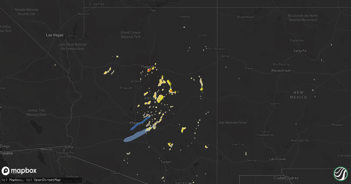
Hail Map on August 16, 2021
Get this storm
August 16 map
$229
one time, instant access
Download today. No call, no setup
Keep the $229
Bought the map and want the full workflow? Apply the entire $229 to a subscription within 7 days. None of it is wasted.
Every map, not just this one
This buys you this map. Subscription and you get every map we run, in the markets you choose from a few cities to whole states to nationwide. Plus real-time alerts the moment a storm fires.
Contact data
Name, contact info, occupancy, even credit band for addresses in the footprint. You go from where it hit to who to call.
Become the source they trust
Unlimited branding weather history reports on demand. You already have the documented answer ready for the property owner, and you are the one who showed up with it.
Property data and RoofTrace estimates
Pull up any address you have got, its value and the exact code rules for that jurisdiction, straight from One Click Code. Then RoofTrace estimates the squares, pitch, and roof value, priced the way you price.
States Impacted by Hail Map on August 16, 2021
Storm reports
Texas
| Date | Description |
|---|---|
| 08/16/20213:03 PM CDT | Large tree limbs 1 to 3 inches in diameter were blown down. |
| 08/16/20212:58 PM CDT | Wind flipped over a large air conditioning unit mounted on the roof of white deer elementary school. Time estimated from radar. |
| 08/16/20212:37 PM CDT | Sheriff reported hail along with heavy rain in the kingsmill area. |
| 08/16/20211:57 PM CDT | Awos station kppa pampa. |
| 08/16/20211:08 PM CDT | Corrects report source from previous tstm wnd gst report from 9 nnw pampa. Spotter estimates a 60 mph gust with trees bending nearly 90 degrees. |
| 08/16/20217:39 AM CDT | At 1239 PM CDT, a severe thunderstorm was located 12 miles north of Pampa, moving east at 10 mph. HAZARD...Ping pong ball size hail and 60 mph wind gusts. SOURCE...Radar indicated. IMPACT...Minor damage to roofs, siding, and trees is possible. People and animals outdoors will be injured. Expect hail damage to roofs, siding, windows, and vehicles. This severe thunderstorm will remain over mainly rural areas of southwestern Roberts County. |
| 08/16/20212:22 AM CDT | At 722 PM CDT, a severe thunderstorm was located 7 miles northwest of Caprock, or 9 miles northeast of Slaton, moving west at 10 mph. HAZARD...60 mph wind gusts. SOURCE...Radar indicated. IMPACT...Expect damage to roofs, siding, and trees. Locations impacted include... Lubbock, Slaton, Idalou, Ransom Canyon and Buffalo Springs. |
| 08/16/202112:32 AM CDT | At 532 PM CDT, a severe thunderstorm was located 6 miles southwest of Dundee, moving north at 10 mph. HAZARD...60 mph wind gusts and quarter size hail. SOURCE...Radar indicated. IMPACT...Hail damage to vehicles is expected. Expect wind damage to roofs, siding, and trees. Locations impacted include... Dundee, Mankins, Mabelle, Lake Kickapoo, Lake Diversion and northeastern Lake Kemp. |
| 08/16/202112:09 AM CDT | At 509 PM CDT, a severe thunderstorm was located 8 miles northeast of Turkey, moving east at 20 mph. HAZARD...Golf ball size hail and 60 mph wind gusts. SOURCE...Radar indicated. IMPACT...People and animals outdoors will be injured. Expect hail damage to roofs, siding, windows, and vehicles. Expect wind damage to roofs, siding, and trees. Locations impacted include... Lakeview and Plaska Community. |
| 08/15/202110:18 PM CDT | At 318 PM CDT, a severe thunderstorm was located over Lake Mcclellan, or 18 miles north of Clarendon, moving southeast at 20 mph. HAZARD...70 mph wind gusts and ping pong ball size hail. SOURCE...Radar indicated. IMPACT...Expect some tree damage. Damage is likely to mobile homes, roofs, and outbuildings. People and animals outdoors will be injured. Expect hail damage to roofs, siding, windows, and vehicles. Locations impacted include... Howardwick, Lake Mcclellan, Alanreed and Greenbelt Lake. |
| 08/15/20219:54 PM CDT | At 253 PM CDT, a severe thunderstorm was located 8 miles southeast of White Deer, or 14 miles south of Pampa, moving south at 15 mph. HAZARD...70 mph wind gusts and ping pong ball size hail. SOURCE...Radar indicated. IMPACT...Expect some tree damage. Damage is likely to mobile homes, roofs, and outbuildings. People and animals outdoors will be injured. Expect hail damage to roofs, siding, windows, and vehicles. Locations impacted include... White Deer, Groom, Kingsmill and Lake Mcclellan. |
| 08/15/20219:09 PM CDT | At 209 PM CDT, a severe thunderstorm was located 4 miles west of Pampa, moving southwest at 15 mph. HAZARD...60 mph wind gusts and quarter size hail. SOURCE...Radar indicated. IMPACT...Minor damage to roofs, siding, and trees is possible. Hail damage to vehicles is expected. Locations impacted include... Pampa, Panhandle, White Deer, Skellytown and Kingsmill. |
| 08/15/20218:42 PM CDT | At 142 PM CDT, a severe thunderstorm was located 8 miles north of Pampa, moving south at 5 mph. HAZARD...60 mph wind gusts and quarter size hail. SOURCE...Radar indicated. IMPACT...Minor damage to roofs, siding, and trees is possible. Hail damage to vehicles is expected. Locations impacted include... Pampa. |
Idaho
| Date | Description |
|---|---|
| 08/15/20218:25 PM CDT | Several residents described sudden wind storm occurring with little if any rain and lasting about 5 to 10 minutes between approximately 7:20 pm and 7:30 pm. A resident |
Virginia
| Date | Description |
|---|---|
| 08/16/20215:57 PM CDT | Thunderstorm winds blew down one tree near the intersection of cassell drive and morning side drive. |
| 08/16/20215:49 PM CDT | Thunderstorm winds blew down one tree on route 220 blocking one of the southbound lanes near the intersection of branscome drive. |
Georgia
| Date | Description |
|---|---|
| 08/16/20216:32 AM CDT | Emergency manager reported a tree down in the road at hickory leaf road and jordan road |
| 08/16/20216:15 AM CDT | Emergency manager reported a tree down in the road around halehaven drive and fortune court |
| 08/16/20216:00 AM CDT | A portion of a barn collapsed near the intersection of old farmington rd and astondale rd |
| 08/16/20215:37 AM CDT | Emergency manager reported a tree down blocking the road on edward hill road |
| 08/16/20215:37 AM CDT | Tree blocking the road at edward hill rd |
| 08/16/20215:28 AM CDT | Report of a few trees downed near union hill church rd and kitchens rd |
| 08/16/20215:28 AM CDT | Emergency manager reported a few trees down around union hill church road and kitchens road |
| 08/16/20215:23 AM CDT | Multiple reports of damage... Mainly trees down with minor structural damage... In the arrowhead subdivision. Time estimated from radar. |
| 08/16/20214:51 AM CDT | Multiple trees downed near prospect church rd and hwy 96 |
| 08/16/20214:48 AM CDT | Multiple reports of damage in the area of missle base rd. Boats overturned at academy sports distribution center...damage to a nearby pump house...and a tractor trailer |
| 08/16/20213:51 AM CDT | 3 trees down on road at norwood rd. And ralls rd. |
| 08/16/20213:44 AM CDT | Tree down at mooty bridge rd. And cameron mill rd. |
| 08/16/20213:42 AM CDT | Tree down along antioch rd. |
| 08/16/20213:41 AM CDT | Tree down along hudson rd. |
| 08/16/20213:37 AM CDT | Tree down along ashford circle. |
| 08/16/20213:34 AM CDT | Reports of several very large trees down across coleman creek circle associated with a radar confirmed tornadic circulation around 4:34 am edt |
| 08/16/20213:21 AM CDT | Tree down at gray hill school rd. And jim turner rd. |
| 08/16/20213:19 AM CDT | Tree down on road at old hutchinson mill rd. And mcgraw rd. |
| 08/16/20213:18 AM CDT | Tree down at robert taylor rd. And cannonville rd. |
| 08/16/20213:04 AM CDT | Tree down at stovall rd. And hamby rd. |
| 08/16/202112:25 AM CDT | Likely tornado damage near pinecrest dr and sharon dr in americus. Many trees down... Several on structures. |
Montana
| Date | Description |
|---|---|
| 08/16/20216:07 PM CDT | Outbuilding displaced by wind. |
| 08/16/20216:04 PM CDT | A local report indicates 59 MPH wind near 3 NW BILLINGS |
| 08/16/20214:14 PM CDT | A local report indicates 63 MPH wind near 6 SE JACKSON |
| 08/15/202111:56 PM CDT | At 456 PM MDT, a severe thunderstorm was located near Billings West End, or 8 miles northwest of Billings, moving east at 35 mph. HAZARD...60 mph wind gusts and pea size hail. SOURCE...Radar indicated. IMPACT...Expect damage to roofs, siding, and trees. Locations impacted include... Shepherd, Huntley, Worden, Ballantine, Pompeys Pillar and Acton. |
| 08/15/20217:59 PM CDT | A local report indicates 59 MPH wind near 3 SSE CROW AGENCY |
| 08/15/20217:12 PM CDT | A local report indicates 58 MPH wind near 17 NE WILSALL |
Oklahoma
| Date | Description |
|---|---|
| 08/16/20213:43 AM CDT | At 842 PM CDT, a severe thunderstorm was located near Blanchard, moving southwest at 25 mph. HAZARD...60 mph wind gusts and dime size hail. SOURCE...Radar indicated. IMPACT...Expect damage to roofs, siding, and trees. Locations impacted include... Newcastle, Blanchard, Dibble and Middleberg. |
| 08/16/20212:54 AM CDT | At 753 PM CDT, a severe thunderstorm was located near Newcastle, moving south at 5 mph. HAZARD...60 mph wind gusts and quarter size hail. SOURCE...Radar indicated. IMPACT...Hail damage to vehicles is expected. Expect wind damage to roofs, siding, and trees. Locations impacted include... Southern Oklahoma City, western Norman, Moore, Newcastle, Blanchard, Tuttle, Goldsby and Bridge Creek. |
| 08/16/20211:50 AM CDT | At 650 PM CDT, a severe thunderstorm was located over southwestern Oklahoma City, or near Will Rogers Airport, moving southeast at 10 mph. HAZARD...60 mph wind gusts and quarter size hail. SOURCE...Radar indicated. IMPACT...Hail damage to vehicles is expected. Expect wind damage to roofs, siding, and trees. Locations impacted include... Oklahoma City, western Norman, Moore, Midwest City, Del City, Newcastle, Bethany, Mustang, Warr Acres, The Village, Spencer, Nichols Hills, Valley Brook, Tinker Air Force Base, Stanley Draper Lake, Forest Park, Woodlawn Park, Lake Aluma and Smith Village. |
| 08/15/20218:06 PM CDT | A local report indicates 60 MPH wind near 4 NW NEWCASTLE |
Arizona
| Date | Description |
|---|---|
| 08/16/20215:13 PM CDT | A local report indicates 2.00 inch wind near 4 E FLAGSTAFF AIRPORT |
| 08/16/20215:01 PM CDT | A local report indicates 1.50 inch wind near MOUNTAINAIRE |
| 08/16/20214:48 PM CDT | A local report indicates 1.00 inch wind near 8 E MOUNTAINAIRE |
| 08/16/20214:45 PM CDT | Along lake mary road. Spotter reports several homes with roof damage. |
| 08/16/20213:52 PM CDT | A local report indicates 1.00 inch wind near 2 WSW HEBER-OVERGAARD |
| 08/16/20217:49 AM CDT | At 1248 AM MST, a severe thunderstorm was located near Aguila, or 19 miles west of Wickenburg, moving southwest at 40 mph. HAZARD...60 mph wind gusts and penny size hail. SOURCE...Radar indicated. IMPACT...Expect damage to roofs, siding, and trees. Locations impacted include... Wickenburg, Alamo Lake, Alamo Lake State Park, Aguila, Wenden and Gladden.This includes US Highway 60 between mile markers 61 and 118. |
| 08/16/20217:40 AM CDT | At 1240 AM MST, severe thunderstorms were located along a line extending from 17 miles southwest of Yava to 10 miles southwest of Congress, moving southwest at 20 mph. HAZARD...60 mph wind gusts and quarter size hail. SOURCE...Radar indicated. IMPACT...Hail damage to vehicles is expected. Expect wind damage to roofs, siding, and trees. These severe thunderstorms will remain over mainly rural areas of Yavapai County. |
| 08/16/20217:20 AM CDT | At 1219 PM MST, a severe thunderstorm was located over Oracle, moving south at 5 mph. HAZARD...60 mph wind gusts and quarter size hail. SOURCE...Radar indicated. IMPACT...Hail damage to vehicles is expected. Expect wind damage to roofs, siding, and trees. Locations impacted include... Oracle, Saddlebrooke, Campo Bonito, Biosphere 2 and Oracle Junction. |
| 08/16/20217:08 AM CDT | At 1207 AM MST, a severe thunderstorm was located near Kirkland, or 25 miles southwest of Prescott Valley, moving south at 20 mph. HAZARD...Ping pong ball size hail and 60 mph wind gusts. SOURCE...Radar indicated. IMPACT...People and animals outdoors will be injured. Expect hail damage to roofs, siding, windows, and vehicles. Expect wind damage to roofs, siding, and trees. Locations impacted include... Yarnell, Peeples Valley, Kirkland and Glen Ilah. |
| 08/16/20216:52 AM CDT | At 1151 PM MST, a severe thunderstorm was located near Cave Creek, or 10 miles southeast of New River, moving southwest at 10 mph. HAZARD...60 mph wind gusts and quarter size hail. SOURCE...Radar indicated. IMPACT...Hail damage to vehicles is expected. Expect wind damage to roofs, siding, and trees. Locations impacted include... Phoenix, Scottsdale, New River, Cave Creek, Carefree, Deer Valley Airport and Anthem.This includes the following highways...AZ Interstate 17 between mile markers 218 and 227.AZ Route 74 between mile markers 28 and 30.AZ Route 303 between mile markers 137 and 139. |
| 08/16/20216:41 AM CDT | At 1140 PM MST, severe thunderstorms were located along a line extending from near White Tank Mountain Park to near Palo Verde to 10 miles northeast of Cotton Center to near Estrella to 11 miles west of Chui-Chu, moving southwest at 35 mph. HAZARD...70 mph wind gusts and nickel size hail. SOURCE...Radar indicated. IMPACT...Expect considerable tree damage. Damage is likely to mobile homes, roofs, and outbuildings. Locations impacted include... Avondale, Goodyear, Buckeye, Casa Grande, Gila Bend, Tonopah, Cashion, Maricopa, Estrella, Arizona City, Litchfield Park, Palo Verde, White Tank Mountain Park, Big Horn and Cotton Center.This includes the following highways...AZ Interstate 10 between mile markers 89 and 131.AZ Interstate 8 between mile markers 100 and 176.AZ Route 238 between mile markers 1 and 44. |
| 08/16/20216:31 AM CDT | At 1131 PM MST, a severe thunderstorm was located 8 miles southeast of Black Canyon City, or 9 miles northeast of New River, moving southwest at 10 mph. HAZARD...60 mph wind gusts and quarter size hail. SOURCE...Radar indicated. IMPACT...Hail damage to vehicles is expected. Expect wind damage to roofs, siding, and trees. Locations impacted include... New River, Cave Creek, Lake Pleasant, Seven Springs and Anthem. This includes AZ Interstate 17 between mile markers 227 and 240. |
| 08/16/20216:16 AM CDT | At 1115 PM MST, a severe thunderstorm was located near Arizona City moving southwest at 5 mph. Additional thunderstorms will be developing in the next hour that may become severe. HAZARD...60 mph wind gusts and quarter size hail. SOURCE...Radar indicated. IMPACT...Hail damage to vehicles is expected. Expect wind damage to roofs, siding, and trees. Locations impacted include... Eloy, Picacho, Chui-Chu, Picacho Peak State Park, Red Rock, Cockleburr, North Komelik, Kohatk, Jack Rabbit, Shopishk and East Chui-Chu. |
| 08/16/20215:54 AM CDT | At 1054 PM MST, severe thunderstorms were located along a line extending from near Deer Valley Airport to Arizona State Fairgrounds to South Phoenix to 6 miles east of Bapchule, moving southwest at 30 mph. THESE ARE DESTRUCTIVE STORMS FOR PHOENIX METRO AREA. HAZARD...80 mph wind gusts and quarter size hail. SOURCE...Radar indicated. IMPACT...Flying debris will be dangerous to those caught without shelter. Mobile homes will be heavily damaged. Expect considerable damage to roofs, windows, and vehicles. Extensive tree damage and power outages are likely. Locations impacted include... Phoenix, Mesa, Chandler, Glendale, Scottsdale, Gilbert, Tempe, Peoria, Surprise, Avondale, Goodyear, Buckeye, Casa Grande, Apache Junction and El Mirage.This includes the following highways...AZ Interstate 10 between mile markers 117 and 204.AZ Interstate 17 between mile markers 195 and 237.AZ Interstate 8 between mile markers 146 and 178. |
| 08/16/20215:33 AM CDT | At 1033 PM MST, a severe thunderstorm was located near Horseshoe Reservoir, or 16 miles northwest of Sycamore Creek, moving southwest at 15 mph. HAZARD...60 mph wind gusts and quarter size hail. SOURCE...Radar indicated. IMPACT...Hail damage to vehicles is expected. Expect wind damage to roofs, siding, and trees. Locations impacted include... Horseshoe Reservoir. |
| 08/16/20215:24 AM CDT | At 1023 PM MST, a several severe thunderstorms across eastern Pinal county. One was located near Mammoth while another one was approaching Kearny. These storms were movint to the south around 10 to 15 mph. HAZARD...60 mph wind gusts. SOURCE...Radar indicated. IMPACT...Expect damage to roofs, siding, and trees. Locations impacted include... Oracle, Mammoth, Saddlebrooke, San Manuel, Kearny, Dudleyville, Aravaipa Canyon Wilderness, Cactus Forest, Campo Bonito, Kelvin, Oracle Junction, Biosphere 2 and San Carlos Reservoir. |
| 08/16/20215:14 AM CDT | At 1014 PM MST, severe thunderstorms were located along a line extending from near Camp Creek to near Rio Verde to near Apache Junction to near Gold Canyon to near Superior, moving southwest at 30 mph. HAZARD...70 mph wind gusts and quarter size hail. SOURCE...Radar indicated. IMPACT...Hail damage to vehicles is expected. Expect considerable tree damage. Wind damage is also likely to mobile homes, roofs, and outbuildings. Locations impacted include... Phoenix, Mesa, Chandler, Glendale, Scottsdale, Gilbert, Tempe, Apache Junction, Florence, Fountain Hills, Paradise Valley, Coolidge, Superior, East Mesa and Sunflower.This includes the following highways...AZ Interstate 10 between mile markers 143 and 185.AZ Interstate 17 between mile markers 195 and 241.AZ Route 51 between mile markers 1 and 15. |
| 08/16/20215:01 AM CDT | At 1000 PM MST, severe thunderstorms were located along a line extending from near Horseshoe Reservoir to 7 miles southwest of Rye, moving southwest at 35 mph. HAZARD...60 mph wind gusts and penny size hail. SOURCE...Radar indicated. IMPACT...Expect damage to roofs, siding, and trees. Locations impacted include... Horseshoe Reservoir. |
| 08/16/20214:49 AM CDT | At 949 PM MST, a severe thunderstorm was located near Rye, or 11 miles southwest of Payson, moving southwest at 30 mph. HAZARD...70 mph wind gusts and quarter size hail. SOURCE...Radar indicated. IMPACT...Hail damage to vehicles is expected. Expect considerable tree damage. Wind damage is also likely to mobile homes, roofs, and outbuildings. Locations impacted include... Scottsdale, Round Valley, Ballantine Trailhead, Sugarloaf Mountain, Sycamore Creek, Sunflower, Desert Mountain, Camp Creek and Horseshoe Reservoir.This includes AZ Route 87 between mile markers 204 and 229. |
| 08/16/20214:41 AM CDT | At 941 PM MST, severe thunderstorms were located along a line extending from near Four Peaks to near Apache Lake to Miami, moving south at 15 mph. HAZARD...60 mph wind gusts and penny size hail. SOURCE...Radar indicated. IMPACT...Expect damage to roofs, siding, and trees. Locations impacted include... Superior, Miami, Queen Valley, Canyon Lake, Superstition Mountains, Lost Dutchman State Park, Goldfield, Apache Lake, Boyce Thompson Arboretum, Top-Of-The-World, Gold Camp and Tortilla Flat.This includes the following highways...US Highway 60 between mile markers 218 and 243.AZ Route 77 near mile marker 156.AZ Route 177 between mile markers 159 and 167. |
| 08/16/20214:22 AM CDT | At 922 PM MST, severe thunderstorms were located along a line extending from 6 miles east of Jakes Corner to Roosevelt Dam to near Claypool, moving west at 10 mph. HAZARD...60 mph wind gusts and penny size hail. SOURCE...Radar indicated. IMPACT...Expect damage to roofs, siding, and trees. Locations impacted include... Globe, Roosevelt, Miami, Punkin Center, Roosevelt Dam, Claypool, Central Heights-Midland City, Tonto Basin, Tonto National Monument, Four Peaks, Apache Lake, Inspiration and Roosevelt Estates.This includes the following highways...US Highway 60 between mile markers 240 and 261.AZ Route 87 between mile markers 220 and 229.AZ Route 70 between mile markers 253 and 255. |
| 08/16/20214:18 AM CDT | At 917 PM MST, severe thunderstorms were located along a line extending from Pine to near Haigler Creek, moving south at 25 mph. HAZARD...60 mph wind gusts and quarter size hail. SOURCE...Radar indicated. IMPACT...Hail damage to vehicles is expected. Expect wind damage to roofs, siding, and trees. Locations impacted include... Payson, Star Valley, Oxbow Estates, Round Valley, Haigler Creek, Flowing Springs, Mesa Del Caballo, Gisela, Geronimo Estates, Freedom Acres, Pine, Strawberry, East Verde Estates, Jakes Corner, Rye, Houston Mesa Campground, Tonto Natural Bridge State Park, Beaver Valley. |
| 08/16/20213:21 AM CDT | At 820 PM MST, a severe thunderstorm was located over Tremaine Lake moving southwest at 30 mph. HAZARD...Ping pong ball size hail and 60 mph wind gusts. SOURCE...Radar indicated. IMPACT...People and animals outdoors will be injured. Expect hail damage to roofs, siding, windows, and vehicles. Expect wind damage to roofs, siding, and trees. Locations impacted include... Clints Well, Tremaine Lake, Happy Jack, Starlight Pines, Clints Well Campground, Blue Ridge Campground, Long Lake, Rock Crossing Campground and Chavez Mountain. |
| 08/16/20213:04 AM CDT | At 802 PM MST, a severe thunderstorm was located near the Mohave/Coconino County border 12 miles south of I-40 moving southwest at 15 mph. HAZARD...60 mph wind gusts and quarter size hail. SOURCE...Radar indicated. IMPACT...Hail damage to vehicles is expected. Expect wind damage to roofs, siding, and trees. Locations impacted include... Mount Hope. |
| 08/16/20212:57 AM CDT | At 756 PM MST, a severe thunderstorm was located near Starlight Pines moving southwest at 10 mph. HAZARD...60 mph wind gusts and half dollar size hail. SOURCE...Radar indicated. IMPACT...Hail damage to vehicles is expected. Expect wind damage to roofs, siding, and trees. Locations impacted include... Starlight Pines, Tremaine Lake, Chavez Mountain and Long Lake. |
| 08/16/20212:42 AM CDT | At 742 PM MST, a severe thunderstorm was located 23 miles southeast of Diamond M Ranch, or 34 miles northeast of Wikieup, moving southwest at 15 mph. HAZARD...60 mph wind gusts and quarter size hail. SOURCE...Radar indicated. IMPACT...Hail damage to vehicles is expected. Expect wind damage to roofs, siding, and trees. Locations impacted include... Mount Hope. |
| 08/16/20212:37 AM CDT | At 737 PM MST, a severe thunderstorm was located 10 miles northeast of Starlight Pines moving southwest at 10 mph. HAZARD...60 mph wind gusts and half dollar size hail. SOURCE...Radar indicated. IMPACT...Hail damage to vehicles is expected. Expect wind damage to roofs, siding, and trees. Locations impacted include... Chavez Mountain. |
| 08/16/20212:24 AM CDT | At 723 PM MST, Severe thunderstorms were located near Hickiwan, or 20 miles east of Ajo and along Highway 86, moving south at 5 mph. HAZARD...60 mph wind gusts and quarter size hail. SOURCE...Radar indicated. IMPACT...Hail damage to vehicles is expected. Expect wind damage to roofs, siding, and trees. Locations impacted include... San Simon, Charco 27, Gunsight and San Simon West. |
| 08/16/20212:09 AM CDT | At 708 PM MST, a severe thunderstorm was located just north of Tubac, moving south at 10 mph. HAZARD...60 mph wind gusts and nickel size hail. SOURCE...Radar indicated. IMPACT...Expect damage to roofs, siding, and trees. Locations impacted include... Tubac, Tumacacori and Amado. |
| 08/16/20212:08 AM CDT | At 707 PM MST, a severe thunderstorm was located 17 miles southwest of Seligman moving southwest at 15 mph. HAZARD...60 mph wind gusts. SOURCE...Radar indicated. IMPACT...Expect damage to roofs, siding, and trees. This severe thunderstorm will remain over mainly rural areas of Yavapai County. |
| 08/16/20211:59 AM CDT | Flood control district of maricopa county az alert mesonet station. |
| 08/16/20211:56 AM CDT | Awos station kcgz casa granda. |
| 08/16/20211:45 AM CDT | **delayed report** several downed trees within neighborhoods surrounding estrella parkway and yuma rd. Largest tree was 40 ft tall. Radar estimated winds were 45-55 mph |
| 08/16/20211:40 AM CDT | *** delayed report *** photo from social media post shows palm tree split in half resulting in damage to a parked car and wooden fence. No injuries reported. |
| 08/16/20211:33 AM CDT | At 633 PM MST, a severe thunderstorm was located near Page Springs, or near Sedona, moving southeast at 5 mph. HAZARD...60 mph wind gusts and quarter size hail. SOURCE...Radar indicated. IMPACT...Hail damage to vehicles is expected. Expect wind damage to roofs, siding, and trees. Locations impacted include... Page Springs and Red Rock State Park. |
| 08/16/20211:31 AM CDT | Mesonet station fw4391 avondale. |
| 08/16/20211:16 AM CDT | Corrects timing of previous tstm wnd gst report from 5 nnw casa grande. Awos station kcgz casa granda. |
| 08/16/20211:16 AM CDT | ***delayed report *** photo shows downed power pole. |
| 08/16/20211:14 AM CDT | *** delayed report*** mesonet station srp42 4.1 s coolidge |
| 08/16/20211:14 AM CDT | At 613 PM MST, a severe thunderstorm was located near San Carlos, or 21 miles east of Globe, moving southeast at 10 mph. HAZARD...60 mph wind gusts and quarter size hail. SOURCE...Radar indicated. IMPACT...Hail damage to vehicles is expected. Expect wind damage to roofs, siding, and trees. Locations impacted include... Globe, San Carlos, Cutter and Central Heights-Midland City. This includes the following highways...US Highway 60 between mile markers 250 and 255.AZ Route 70 between mile markers 253 and 271.AZ Route 77 between mile markers 163 and 170. |
| 08/16/20211:11 AM CDT | At 611 PM MST, a severe thunderstorm was located 9 miles southeast of San Carlos, or 25 miles east of Globe, moving south at 10 mph. HAZARD...60 mph wind gusts and quarter size hail. SOURCE...Radar indicated. IMPACT...Hail damage to vehicles is expected. Expect wind damage to roofs, siding, and trees. Locations impacted include... Bylas, Calva and San Carlos Reservoir. |
| 08/16/20211:10 AM CDT | *** delayed report *** photo from social media shows large tree uprooted. Time estimated using radar. |
| 08/16/20211:08 AM CDT | *** delayed report *** six-inch diameter tree limb broken off palo verde tree. |
| 08/16/20211:04 AM CDT | ***delayed report***large tree down on power lines near lower buckeye between 67th and 75th ave. Time of 60-65 mph winds estimated by tphx radar. |
| 08/16/20211:00 AM CDT | *** delayed report *** photo from social media shows multiple trees uprooted |
| 08/16/202112:56 AM CDT | A local report indicates 59 MPH wind near 9 SE QUEEN CREEK |
| 08/16/202112:55 AM CDT | *** delayed report *** measured from handheld anemometer. |
| 08/16/202112:53 AM CDT | Asos station kphx phoenix sky hrbr. |
| 08/16/202112:50 AM CDT | *** delayed report *** one large tree about 4 feet in diameter uprooted near oasis ln and hunt hwy. Time estimated from radar. |
| 08/16/202112:50 AM CDT | *** delayed report *** multiple reports of trees down and a trampoline along hunt hwy. Between gary rd. And bella vista rd. A fence was destroyed by a downed tree near |
| 08/16/202112:40 AM CDT | Srp mesonet station quail. |
| 08/16/202112:35 AM CDT | At 534 PM MST, a severe thunderstorm was located over East Sahuarita, or near Sahuarita, with another severe storm near Rita Ranch and both are nearly stationary. HAZARD...60 mph wind gusts and quarter size hail. SOURCE...Radar indicated. IMPACT...Hail damage to vehicles is expected. Expect wind damage to roofs, siding, and trees. Locations impacted include... Tucson, Sahuarita, Green Valley, Vail, East Sahuarita, Summit and Rita Ranch. |
| 08/16/202112:20 AM CDT | Mature lemon tree uprooted and some lawn furniture damaged/displaced. Mostly smaller trees pulled out of the ground or broken - limbs. 8 to 10 trees. Two mature ocotill |
| 08/15/202111:44 PM CDT | At 444 PM MST, a severe thunderstorm was located 14 miles southeast of Solomon, or 18 miles southeast of Safford, and is nearly stationary. HAZARD...60 mph wind gusts and quarter size hail. SOURCE...Radar indicated. IMPACT...Hail damage to vehicles is expected. Expect wind damage to roofs, siding, and trees. This severe thunderstorm will remain over mainly remote areas of southeastern Graham County. |
| 08/15/202111:34 PM CDT | At 434 PM MST, a severe thunderstorm was located near Gisela, or 9 miles southeast of Payson, moving southwest at 15 mph. HAZARD...60 mph wind gusts and quarter size hail. SOURCE...Radar indicated. IMPACT...Hail damage to vehicles is expected. Expect wind damage to roofs, siding, and trees. Locations impacted include... Oxbow Estates, Round Valley, Jakes Corner, Gisela, Rye and Deer Creek. |
| 08/15/202111:25 PM CDT | At 424 PM MST, a severe thunderstorm was located 7 miles south of Concho moving southeast at 15 mph. HAZARD...60 mph wind gusts and quarter size hail. SOURCE...Radar indicated. IMPACT...Hail damage to vehicles is expected. Expect wind damage to roofs, siding, and trees. Locations impacted include... Concho and Little Ortega Lake. |
| 08/15/202111:06 PM CDT | At 405 PM MDT, a severe thunderstorm was located near Hubbell Trading Post National Historic Site, or 34 miles south of Chinle, moving southwest at 20 mph. HAZARD...Quarter size hail. SOURCE...Radar indicated. IMPACT...Damage to vehicles is expected. Locations impacted include... Cornfields Chapter House, Kinlichee Chapter House, Burnside, Klagetoh, Hubbell Trading Post National Historic Site, Sunrise Springs and Ganado. |
| 08/15/202110:57 PM CDT | At 357 PM MST, a severe thunderstorm was located over Concho moving southeast at 15 mph. HAZARD...60 mph wind gusts. SOURCE...Radar indicated. IMPACT...Expect damage to roofs, siding, and trees. Locations impacted include... Concho and Little Ortega Lake. |
| 08/15/202110:39 PM CDT | At 339 PM MST, a severe thunderstorm was located over Tonto Village, or 12 miles east of Payson, moving southeast at 15 mph. HAZARD...60 mph wind gusts and quarter size hail. SOURCE...Radar indicated. IMPACT...Hail damage to vehicles is expected. Expect wind damage to roofs, siding, and trees. Locations impacted include... Tonto Village, Haigler Creek, Kohls Ranch, Hunter Creek, Christopher Creek, Bear Flat, Upper Tonto Creek Campground, Christopher Creek Campground, Alderwood Campground, Ponderosa Campground, Sharp Creek Campground and Haigler Canyon Campground. |
| 08/15/20219:41 PM CDT | At 241 PM MST, a severe thunderstorm was located over Mountainaire, or 7 miles south of Flagstaff, moving southwest at 10 mph. HAZARD...Golf ball size hail. SOURCE...Radar indicated. IMPACT...People and animals outdoors will be injured. Expect damage to roofs, siding, windows, and vehicles. Locations impacted include... Flagstaff, Munds Park, Junipine Resort, Garland's Oak Creek Lodge, Kachina Village, Slide Rock State Park, Mountainaire, West Fork Of Oak Creek, Cave Springs Campground, Pine Flat Campground, Manzanita Campground, Sterling Fish Hatchery, Lower Lake Mary and Canyon Vista Campground. |
| 08/15/20219:38 PM CDT | At 237 PM MST, a severe thunderstorm was located near Forest Lakes, moving west at 15 mph. HAZARD...Golf ball size hail. SOURCE...Radar indicated. IMPACT...People and animals outdoors will be injured. Expect damage to roofs, siding, windows, and vehicles. Locations impacted include... Forest Lakes, Forest Road 9350 Campground, Forest Road 169 Campground, Spillway Campground, Promontory Pit Road Campground, Woods Canyon Lake Campground, Chevelon Canyon Dam, Forest Road 195 Campground, Chevelon Canyon Lake Campground and Forest Road 237 Camping Area. |
| 08/15/20219:30 PM CDT | At 229 PM MST/329 PM MDT/, a severe thunderstorm was located over Jeddito, or 7 miles southeast of Keams Canyon, moving southwest at 5 mph. HAZARD...Quarter size hail. SOURCE...Radar indicated. IMPACT...Damage to vehicles is expected. Locations impacted include... Jadito, White Cone, Jeddito and Navajo. |
| 08/15/20219:27 PM CDT | At 226 PM MST, a severe thunderstorm was located 16 miles east of Starlight Pines, or 24 miles north of Forest Lakes, moving southeast at 25 mph. HAZARD...Golf ball size hail. SOURCE...Radar indicated. IMPACT...People and animals outdoors will be injured. Expect damage to roofs, siding, windows, and vehicles. Locations impacted include... Chevelon Butte, Chevelon Crossing Campground, Chevelon Canyon Lake Campground and Chevelon Canyon Dam. |
| 08/15/20219:25 PM CDT | At 225 PM MST, a severe thunderstorm was located near Walnut Canyon National Monument, or near Flagstaff, and is nearly stationary. HAZARD...Ping pong ball size hail. SOURCE...Radar indicated. IMPACT...People and animals outdoors will be injured. Expect damage to roofs, siding, windows, and vehicles. Locations impacted include... Mountainaire, Walnut Canyon National Monument, Mormon Lake, Upper Lake Mary, Upper Lake Mary Boat Ramps, Pinegrove Campground, Lower Lake Mary, Canyon Vista Campground and Lake View Campground. |
| 08/15/20218:54 PM CDT | At 154 AM MST, a severe thunderstorm was located 7 miles east of Bouse, or 27 miles southeast of Parker, moving southwest at 30 mph. HAZARD...60 mph wind gusts and quarter size hail. SOURCE...Radar indicated. IMPACT...Hail damage to vehicles is expected. Expect wind damage to roofs, siding, and trees. Locations impacted include... Quartzsite, Salome, Brenda, Vicksburg Junction, Wenden, Vicksburg, Bouse and Harcuvar.This includes the following highways...AZ Interstate 10 between mile markers 15 and 61.US Highway 60 between mile markers 31 and 69.AZ Route 72 between mile markers 15 and 49. |
| 08/15/20218:47 PM CDT | At 146 PM MST, a severe thunderstorm was located 10 miles northeast of Tremaine Lake, or 24 miles southwest of Winslow, moving southeast at 20 mph. HAZARD...Quarter size hail. SOURCE...Radar indicated. IMPACT...Damage to vehicles is expected. Locations impacted include... Starlight Pines, Chevelon Butte and Chavez Mountain. |
| 08/15/20218:38 PM CDT | At 137 PM MST, a severe thunderstorm was located 9 miles west of Aripine, or 12 miles east of Forest Lakes, and is nearly stationary. HAZARD...Up to quarter size hail. SOURCE...Radar indicated. IMPACT...Hail damage to vehicles is expected. Locations impacted include... Heber-overgaard. |
| 08/15/20218:30 PM CDT | At 129 PM MST, a severe thunderstorm was located near Winona, or 10 miles east of Flagstaff, and is nearly stationary. HAZARD...60 mph wind gusts and quarter size hail. SOURCE...Radar indicated. IMPACT...Hail damage to vehicles is expected. Expect wind damage to roofs, siding, and trees. Locations impacted include... Cosnino, Angell, Winona, Walnut Canyon National Monument, Twin Arrows, Walnut Canyon Visitors Center and Upper Lake Mary. |
| 08/15/20218:27 PM CDT | At 127 PM MST, a severe thunderstorm was located 11 miles southwest of Dudleyville, or 11 miles west of Mammoth, and is nearly stationary. HAZARD...60 mph wind gusts and quarter size hail. SOURCE...Radar indicated. IMPACT...Hail damage to vehicles is expected. Expect wind damage to roofs, siding, and trees. Locations impacted include... Dudleyville. |
| 08/15/20218:00 PM CDT | At 1259 AM MST, severe thunderstorms were located along a line extending from 17 miles north of Gladden to 6 miles east of Aguila, moving southwest at 15 mph. HAZARD...60 mph wind gusts and half dollar size hail. SOURCE...Radar indicated. IMPACT...Hail damage to vehicles is expected. Expect wind damage to roofs, siding, and trees. These severe thunderstorms will remain over mainly rural areas of Yavapai County. |
Cities Impacted by Hail Map on August 16, 2021
- Holbrook, AZ
- Roosevelt, AZ
- Flagstaff, AZ
- Tucson, AZ
- Wichita, KS
- Buna, TX
- Sedona, AZ
- Queen Creek, AZ
- Pampa, TX
- Clarendon, TX
- San Carlos, AZ
- Pima, AZ
- Seligman, AZ
- Forest Lakes, AZ
- Miami, TX
- Gold Canyon, AZ
- San Tan Valley, AZ
- Vega, TX
- Payson, AZ
- Wagon Mound, NM
- Prescott, AZ
- Kermit, TX
- Plainview, TX
- Pinon, AZ
- Tubac, AZ
- Tumacacori, AZ
- Amado, AZ
- Happy Jack, AZ
- Seymour, TX
- Arkansas City, KS
- Heber, AZ
- Sunray, TX
- Lone Wolf, OK
- Fort Mcdowell, AZ
- Tonto Basin, AZ
- Perryton, TX
- Merryville, LA
- Scottsdale, AZ
- Pawnee, OK
- Simpson, KS
- Glasco, KS
- Beloit, KS
- Fountain Hills, AZ
- Ganado, AZ
- Borger, TX
- Peridot, AZ
- Bon Wier, TX
- Call, TX
- Vidor, TX
- Dexter, KS
- Apache Junction, AZ
- Elfrida, AZ
- Groom, TX
- Pine, AZ
- Holliday, TX
- Sells, AZ
- Oracle, AZ
- Las Vegas, NM
- Mesa, AZ
- Olney, TX
- Haskell, TX
- Fairview, OK
- Westlake, LA
- Sulphur, LA
- Cypress, TX
- Mayer, AZ
- Cornville, AZ
- Willcox, AZ
- Albany, TX
- Skellytown, TX
- White Deer, TX
- Concho, AZ
- Houston, TX
- Munds Park, AZ
- Paducah, TX
- Higgins, TX
- Black Canyon City, AZ
- Fort Scott, KS
- Beaumont, TX
- Dumas, TX
- Rio Verde, AZ
- Sahuarita, AZ
- Maple City, KS
- Winfield, KS
- Gilbert, AZ
- Laverne, OK
- Encino, NM
- Yale, OK
- Maramec, OK
- Crosby, TX
- Green Valley, AZ
- Bellaire, TX
- Hobart, OK
- Floyd, NM
- Newcastle, OK
- Olton, TX
- Hart, TX
- Roy, NM
- Blanchard, OK
- Oklahoma City, OK
- Tuttle, OK
- Bapchule, AZ
- Coolidge, AZ
- Chandler, AZ
- Maricopa, AZ
- Tempe, AZ
- Laveen, AZ
- Phoenix, AZ
- Overgaard, AZ
- Apalachicola, FL
- Blountstown, FL
- Hosford, FL
- Wewahitchka, FL
- Eastpoint, FL
- Carrabelle, FL
- Bristol, FL
- Crawfordville, FL
- Sopchoppy, FL
- Panacea, FL
- Lynn Haven, FL
- Youngstown, FL
- Panama City, FL
- Panama City Beach, FL
- Chipley, FL
- Grantville, GA
- Luthersville, GA
- Wagener, SC
- Mauldin, SC
- Webster, MA
- North Grosvenordale, CT
- Americus, GA
- Madison, GA
- Greensboro, GA
- Commerce, GA
- Danielsville, GA
- Hull, GA
- Homer, GA
- Gray Court, SC
- Fountain Inn, SC
- North Augusta, SC
- Clarks Hill, SC
- Batesburg, SC
- Leesville, SC
- Prosperity, SC
- Chapin, SC
- Orangeburg, SC
- Stony Point, NC
- Statesville, NC
- Union Grove, NC
- Ronda, NC