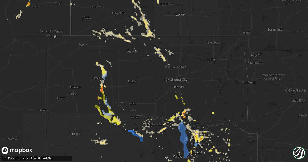
Hail Map in Oklahoma on August 16, 2020
Get this storm
August 16 map
$229
one time, instant access
Download today. No call, no setup
Keep the $229
Bought the map and want the full workflow? Apply the entire $229 to a subscription within 7 days. None of it is wasted.
Every map, not just this one
This buys you this map. Subscription and you get every map we run, in the markets you choose from a few cities to whole states to nationwide. Plus real-time alerts the moment a storm fires.
Contact data
Name, contact info, occupancy, even credit band for addresses in the footprint. You go from where it hit to who to call.
Become the source they trust
Unlimited branding weather history reports on demand. You already have the documented answer ready for the property owner, and you are the one who showed up with it.
Property data and RoofTrace estimates
Pull up any address you have got, its value and the exact code rules for that jurisdiction, straight from One Click Code. Then RoofTrace estimates the squares, pitch, and roof value, priced the way you price.
Storm reports in Oklahoma
Oklahoma
| Date | Description |
|---|---|
| 08/16/20205:40 PM CDT | A local report indicates 67 MPH wind near 3 W GOULD |
| 08/16/20205:40 PM CDT | A local report indicates 70 MPH wind near 2 SE BURNEYVILLE |
| 08/16/20205:35 PM CDT | A local report indicates 80 MPH wind near 2 SE BURNEYVILLE |
| 08/16/20205:30 PM CDT | A local report indicates 59 MPH wind near 3 W GOULD |
| 08/16/20205:30 PM CDT | A local report indicates 68 MPH wind near 2 SE BURNEYVILLE |
| 08/16/20204:56 PM CDT | Twitter report. |
| 08/16/20204:55 PM CDT | A local report indicates 70 MPH wind near WILSON |
| 08/16/20204:47 PM CDT | A local report indicates 1.00 inch wind near KINGSTON |
| 08/16/20204:42 PM CDT | Twitter report with picture. |
| 08/16/20204:25 PM CDT | Half dollar to golf ball size hail in ardmore via facebook. |
| 08/16/20204:24 PM CDT | Quarter size hail with picture via twitter. |
| 08/16/20204:04 PM CDT | A local report indicates 1.00 inch wind near 2 S WYNNEWOOD |
| 08/16/20203:57 PM CDT | Pea to quarter size hail at wynnewood zoo. Pic sent via facebook. Time estimated from radar. |
| 08/16/20203:41 PM CDT | A local report indicates 1.00 inch wind near 1 SSE PAOLI |
| 08/16/20203:02 PM CDT | A local report indicates 1.00 inch wind near PAYNE |
| 08/16/20206:38 AM CDT | At 1138 AM CDT, a severe thunderstorm was located 4 miles south of Drummond, moving southeast at 20 mph. HAZARD...60 mph wind gusts and quarter size hail. SOURCE...Radar indicated. IMPACT...Hail damage to vehicles is expected. Expect wind damage to roofs, siding, and trees. Locations impacted include... Enid, Hennessey, Waukomis, Lahoma, Dover, Drummond, Ames, Vance Air Force Base, Bison and Lacey. |
| 08/16/20205:54 AM CDT | At 1054 AM CDT, a severe thunderstorm was located near Ringwood, moving southeast at 15 mph. HAZARD...60 mph wind gusts and quarter size hail. SOURCE...Radar indicated. IMPACT...Hail damage to vehicles is expected. Expect wind damage to roofs, siding, and trees. Locations impacted include... Enid, Fairview, Helena, Lahoma, Ringwood, Drummond, Cleo Springs, Goltry, Ames, Meno, Aline, Carrier, Orienta and Isabella. |
| 08/16/20203:10 AM CDT | At 809 PM CDT, the leading edge of winds from a line of severe thunderstorms was located along a line extending from 4 miles southwest of Randlett to near Dean to 3 miles southeast of Jolly, moving east at 30 mph. HAZARD...60 mph wind gusts. SOURCE...Radar indicated. IMPACT...Expect damage to roofs, siding, and trees. Locations impacted include... Northeastern Wichita Falls, Burkburnett, Henrietta, Temple, Ryan, Petrolia, Byers, Dean, Randlett, Terral, Jolly, Sugden, Sheppard AFB, Taylor, Charlie and Cashion. |
| 08/16/20202:44 AM CDT | At 744 PM CDT, severe thunderstorms were located along a line extending from 3 miles southeast of Electra to 5 miles northeast of Mankins to 3 miles northwest of Holliday, moving east at 25 mph. HAZARD...60 mph wind gusts. SOURCE...Radar indicated. IMPACT...Expect damage to roofs, siding, and trees. Locations impacted include... Wichita Falls, Burkburnett, Iowa Park, Electra, Dean, Randlett, Sheppard AFB, Pleasant Valley and Cashion. |
| 08/16/20202:23 AM CDT | At 723 PM CDT, a severe thunderstorm was located near Whitewright, or 9 miles southwest of Bonham, moving east at 20 mph. HAZARD...60 mph wind gusts and nickel size hail. SOURCE...Radar indicated. IMPACT...Expect damage to roofs, siding, and trees. Locations impacted include... Bonham, Leonard, Whitewright, Wolfe City, Bells, Tom Bean, Savoy, Ector, Dodd City, Bailey, Ravenna, Bonham State Park, Trenton and Windom. |
| 08/16/20202:02 AM CDT | At 702 PM CDT, severe thunderstorms were located along a line extending from near Frederick to 4 miles north of Vernon to 5 miles west of Grayback, moving east at 40 mph. HAZARD...70 mph wind gusts and quarter size hail. SOURCE...Radar indicated. IMPACT...Hail damage to vehicles is expected. Expect considerable tree damage. Wind damage is also likely to mobile homes, roofs, and outbuildings. Locations impacted include... Vernon, Frederick, Iowa Park, Electra, Grandfield, Tipton, Olustee, Chattanooga, Davidson, Manitou, Elmer, Hollister, Loveland, Harrold, Lockett, Fargo, Humphreys, Odell, Oklaunion and Grayback. |
| 08/16/20201:33 AM CDT | At 632 PM CDT, severe thunderstorms were located along a line extending from 5 miles northeast of Eldorado to 6 miles northwest of Chillicothe to 4 miles northwest of Margaret, moving east at 45 mph. HAZARD...70 mph wind gusts and quarter size hail. SOURCE...Radar indicated. IMPACT...Hail damage to vehicles is expected. Expect considerable tree damage. Wind damage is also likely to mobile homes, roofs, and outbuildings. Locations impacted include... Vernon, Frederick, Quanah, Tipton, Chillicothe, Olustee, Eldorado, Davidson, Manitou, Elmer, Thalia, Margaret, Lockett, Fargo, Medicine Mound, Humphreys, Odell, Oklaunion, Grayback and Rayland. |
| 08/16/20201:30 AM CDT | At 629 PM CDT, severe thunderstorms were located along a line extending from Whitesboro to near Princeton, moving southeast at 20 mph. HAZARD...60 mph wind gusts and quarter size hail. SOURCE...Radar indicated. IMPACT...Hail damage to vehicles is expected. Expect wind damage to roofs, siding, and trees. Locations impacted include... Plano, McKinney, Carrollton, Frisco, Denton, Richardson, Lewisville, Allen, Flower Mound, Wylie, Coppell, Sherman, The Colony, Southlake, Sachse, Corinth, Gainesville, Highland Village, Addison and Lake Dallas.This includes Interstate 35E between mile markers 446 and 465. |
| 08/16/20201:09 AM CDT | At 609 PM CDT, severe thunderstorms were located along a line extending from 6 miles south of Hollis to 6 miles southwest of Goodlett to 12 miles southeast of Swearingen, moving east at 25 mph. HAZARD...70 mph wind gusts and quarter size hail. SOURCE...Radar indicated. IMPACT...Hail damage to vehicles is expected. Expect considerable tree damage. Wind damage is also likely to mobile homes, roofs, and outbuildings. Locations impacted include... Quanah, Hollis, Crowell, Chillicothe, Eldorado, Gould, Margaret, Goodlett, Medicine Mound, Duke, Copper Breaks State Park and McQueen. |
| 08/16/202012:51 AM CDT | At 551 PM CDT, the leading edge of winds from a line of severe thunderstorms was located along a line extending from 3 miles north of Hobart to 3 miles west of Martha to 5 miles northwest of Goodlett, moving southeast at 40 mph. HAZARD...60 mph wind gusts. SOURCE...A 67 mph wind gust was measured at the Gould Mesonet along the gust front. IMPACT...Expect damage to roofs, siding, and trees. Locations impacted include... Altus, Vernon, Frederick, Hobart, Quanah, Snyder, Tipton, Blair, Chillicothe, Olustee, Eldorado, Lone Wolf, Mountain Park, Indiahoma, Roosevelt, Manitou, Martha, Elmer, Headrick and Friendship. |
| 08/16/202012:38 AM CDT | At 537 PM CDT, a cluster of severe thunderstorms was located near the Red River, moving south at 30 mph. HAZARD...60 mph wind gusts and quarter size hail. SOURCE...Radar indicated. IMPACT...Hail damage to vehicles is expected. Expect wind damage to roofs, siding, and trees. Locations impacted include... Sherman, Gainesville, Bowie, Whitesboro, Nocona, Pilot Point, Van Alstyne, Howe, Pottsboro, Collinsville, Muenster, Gunter, St. Jo, Lindsay, Callisburg, Knollwood, Dorchester, Lake Kiowa, Ray Roberts Park Johnson Branch and Forestburg.This includes Interstate 35 between mile markers 482 and 503. |
| 08/16/202012:26 AM CDT | At 526 PM CDT, severe thunderstorms were located along a line extending from 13 miles southeast of Memphis to 10 miles south of Cee Vee, moving southeast at 25 mph. HAZARD...70 mph wind gusts and quarter size hail. SOURCE...Radar indicated. IMPACT...Hail damage to vehicles is expected. Expect considerable tree damage. Wind damage is also likely to mobile homes, roofs, and outbuildings. Locations impacted include... Childress, Paducah, Cee Vee, Tell, Kirkland, Northfield, Delwin, Chalk, Swearingen, Hackberry and Estelline. |
| 08/15/202011:46 PM CDT | At 446 PM CDT, severe thunderstorms were located along a line extending from 5 miles west of Mill Creek to near Springer to near Lone Grove, moving southeast at 15 mph. HAZARD...Ping pong ball size hail and 60 mph wind gusts. SOURCE...Public. IMPACT...People and animals outdoors will be injured. Expect hail damage to roofs, siding, windows, and vehicles. Expect wind damage to roofs, siding, and trees. Locations impacted include... Ardmore, Sulphur, Madill, Tishomingo, Davis, Lone Grove, Kingston, Dickson, Mannsville, Springer, Ravia, Mill Creek, Milburn, Dougherty, Gene Autry, Fillmore, Reagan, Turner Falls, Overbrook and Lake Of The Arbuckles. |
| 08/15/202011:19 PM CDT | At 419 PM CDT, severe thunderstorms were located along a line extending from near Springer to 3 miles southeast of Graham to 5 miles northwest of Healdton, moving southwest at 15 mph. HAZARD...60 mph wind gusts and quarter size hail. SOURCE...Radar indicated. IMPACT...Hail damage to vehicles is expected. Expect wind damage to roofs, siding, and trees. Locations impacted include... Ardmore, Lone Grove, Healdton, Wilson, Dickson, Ringling, Springer, Gene Autry, Graham, Overbrook, Lake Murray, Milo and Cornish. |
| 08/15/202010:57 PM CDT | At 356 PM CDT, a severe thunderstorm was located near Wynnewood, moving south at 15 mph. HAZARD...60 mph wind gusts and quarter size hail. SOURCE...Radar indicated. IMPACT...Hail damage to vehicles is expected. Expect wind damage to roofs, siding, and trees. Locations impacted include... Pauls Valley, Sulphur, Davis, Wynnewood, Lake Of The Arbuckles and Turner Falls. |
| 08/15/202010:42 PM CDT | At 342 PM CDT, a severe thunderstorm was located near Mill Creek, moving southwest at 10 mph. Another severe thunderstorm was located near Gene Autry moving south at 10 mph. HAZARD...60 mph wind gusts and quarter size hail. SOURCE...Radar indicated. IMPACT...Hail damage to vehicles is expected. Expect wind damage to roofs, siding, and trees. Locations impacted include... Ardmore, Sulphur, Dickson, Springer, Mill Creek, Dougherty, Gene Autry and Lake Of The Arbuckles. |
| 08/15/202010:23 PM CDT | At 323 PM CDT, a severe thunderstorm was located 12 miles southwest of Lipscomb, moving southeast at 15 mph. HAZARD...60 mph wind gusts and quarter size hail. SOURCE...Radar indicated. IMPACT...Minor damage to roofs, siding, and trees is possible. Hail damage to vehicles is expected. Locations impacted include... Lipscomb, Canadian, Higgins, Glazier and Lake Marvin. |
| 08/15/202010:14 PM CDT | At 314 PM CDT, a severe thunderstorm was located over Paoli, moving south at 20 mph. HAZARD...60 mph wind gusts and quarter size hail. SOURCE...Radar indicated. IMPACT...Hail damage to vehicles is expected. Expect wind damage to roofs, siding, and trees. Locations impacted include... Pauls Valley, Wynnewood, Paoli, Rosedale and Whitebead. |
| 08/15/202010:08 PM CDT | At 307 PM CDT, a severe thunderstorm was located 6 miles east of Lindsay, moving southeast at 10 mph. HAZARD...60 mph wind gusts and quarter size hail. SOURCE...Public. IMPACT...Hail damage to vehicles is expected. Expect wind damage to roofs, siding, and trees. Locations impacted include... Lindsay, Maysville, Erin Springs, Payne and Whitebead. |
| 08/15/20209:07 PM CDT | At 206 PM CDT, a severe thunderstorm was located near Lane, moving southeast at 10 mph. HAZARD...60 mph wind gusts and quarter size hail. SOURCE...Radar indicated. IMPACT...Hail damage to vehicles is expected. Expect wind damage to roofs, siding, and trees. Locations impacted include... Lane, McGee Creek Lake and Darwin. |
All States Impacted by Hail Map on August 16, 2020
Cities Impacted by Hail Map on August 16, 2020
- Woodville, TX
- Cleveland, TX
- Liberty, TX
- Camden, MS
- Canton, MS
- New Waverly, TX
- Iowa, LA
- Welsh, LA
- Mullinville, KS
- Greensburg, KS
- Quinlan, TX
- Hoskins, NE
- Winside, NE
- Mclean, TX
- Marietta, OK
- Sun City, KS
- Lake City, KS
- Medicine Lodge, KS
- Coats, KS
- Pratt, KS
- Windthorst, TX
- Bee, NE
- Garland, NE
- Moorefield, NE
- Ringwood, OK
- Meno, OK
- Wittmann, AZ
- Champion, NE
- Clarks, NE
- Central City, NE
- Fullerton, NE
- Genoa, NE
- Silver Creek, NE
- Enid, OK
- Fairmont, OK
- Fort Worth, TX
- Culbertson, NE
- McCook, NE
- Mankato, KS
- Protection, KS
- Ashland, KS
- Natoma, KS
- Nacogdoches, TX
- Palestine, TX
- Frankston, TX
- Rush, CO
- Dallas, TX
- Jayton, TX
- Girard, TX
- Snyder, TX
- Mckinney, TX
- Princeton, TX
- Beaver, OK
- Winters, TX
- Wahoo, NE
- Memphis, NE
- Waverly, NE
- Mead, NE
- Prague, NE
- Colon, NE
- Greenwood, NE
- Ithaca, NE
- Weston, NE
- Malmo, NE
- Morse Bluff, NE
- Yutan, NE
- North Bend, NE
- Ceresco, NE
- Eagle, NE
- Alvo, NE
- Cedar Bluffs, NE
- Ashland, NE
- Glen Elder, KS
- Cawker City, KS
- Canadian, TX
- Sutton, NE
- Edgar, NE
- Helena, OK
- Kaufman, TX
- Kirk, CO
- Ardmore, OK
- Springer, OK
- Alva, OK
- Holyoke, CO
- Wray, CO
- Imperial, NE
- Parks, NE
- Davis, OK
- Lone Grove, OK
- Trinidad, TX
- Red Oak, TX
- Cedar Hill, TX
- Midlothian, TX
- Bellwood, NE
- David City, NE
- Columbus, NE
- Miami, TX
- Amherst, NE
- Royse City, TX
- Caddo Mills, TX
- Hugoton, KS
- Liberal, KS
- Prentiss, MS
- Elm Creek, NE
- Wichita Falls, TX
- Wilson, OK
- Lena, MS
- Forest, MS
- Raleigh, MS
- Eckley, CO
- Idalia, CO
- Sallis, MS
- Deridder, LA
- Alexandria, NE
- Carthage, MS
- Apple Springs, TX
- Crockett, TX
- Moscow, TX
- Livingston, TX
- Elkhart, TX
- Grapeland, TX
- Kennard, TX
- Corrigan, TX
- Alto, TX
- Pollok, TX
- Diboll, TX
- Saratoga, TX
- Wells, TX
- Groveton, TX
- Lufkin, TX
- Matador, TX
- Ringling, OK
- Lake Creek, TX
- Sulphur Bluff, TX
- Murchison, TX
- Athens, TX
- Eustace, TX
- Stratton, NE
- Agenda, KS
- Gibbon, NE
- Minden, NE
- Shelton, NE
- Burlington, OK
- Lone Oak, TX
- Clay Center, KS
- Miltonvale, KS
- Minneapolis, KS
- Whitewright, TX
- Trenton, TX
- Anna, TX
- Van Alstyne, TX
- Melissa, TX
- Celina, TX
- Leonard, TX
- Blue Ridge, TX
- Howe, TX
- Sherman, TX
- Gunter, TX
- Holliday, TX
- Casa Grande, AZ
- Greenville, TX
- Rosston, OK
- Ordway, CO
- Chapman, NE
- Grand Island, NE
- Phillips, NE
- Republican City, NE
- Onaga, KS
- Sawyer, KS
- Alpha, MN
- Sherburn, MN
- Lebanon, KS
- Esbon, KS
- Madison, MS
- Madill, OK
- Aurora, NE
- Marquette, NE
- Hardtner, KS
- Kiowa, KS
- Big Lake, TX
- Brainard, NE
- Benkelman, NE
- Wakefield, NE
- Farnam, NE
- Brady, NE
- Maxwell, NE
- Curtis, NE
- Plano, TX
- Rose Hill, MS
- Funk, NE
- Holdrege, NE
- Pitkin, LA
- Joes, CO
- Vona, CO
- Bethune, CO
- Stratton, CO
- Gaylord, KS
- Turpin, OK
- Scotland, TX
- Archer City, TX
- Kemp, TX
- Scurry, TX
- Van, TX
- Ben Wheeler, TX
- Syracuse, KS
- Coolidge, KS
- Black Canyon City, AZ
- Childress, TX
- Cee Vee, TX
- Seymour, TX
- Blossom, TX
- Oakwood, TX
- Yuma, CO
- Point, TX
- Cumby, TX
- Emory, TX
- Enterprise, MS
- Clarendon, TX
- Belleville, KS
- Palisade, NE
- Malakoff, TX
- Mabank, TX
- Warren, TX
- Leigh, NE
- Clarkson, NE
- Washington, OK
- Blanchard, OK
- Talco, TX
- Natchez, MS
- Ravenna, NE
- Waynoka, OK
- Mineola, TX
- Quitman, TX
- Paducah, TX
- San Manuel, AZ
- Roaring Springs, TX
- Abilene, TX
- Healdton, OK
- Grand Chenier, LA
- Omaha, NE
- Walnut Grove, MS
- Aline, OK
- Rozel, KS
- Larned, KS
- Brownsboro, TX
- Tennessee Colony, TX
- Kingman, AZ
- Garland, TX
- Rowlett, TX
- Granbury, TX
- Lipan, TX
- Tucson, AZ
- Oracle, AZ
- Dwight, NE
- Lincoln, NE
- Avoca, NE
- Milford, NE
- Murdock, NE
- Rogers, NE
- Linwood, NE
- Syracuse, NE
- Dodge, NE
- Ulysses, NE
- Valparaiso, NE
- Seward, NE
- Malcolm, NE
- Unadilla, NE
- Staplehurst, NE
- Elmwood, NE
- Bruno, NE
- Schuyler, NE
- Pleasant Dale, NE
- Denton, NE
- Beloit, KS
- Clinton, MS
- Carson, MS
- Henrietta, TX
- Haviland, KS
- Bruning, NE
- Dateland, AZ
- Elgin, NE
- Petersburg, NE
- Tilden, NE
- Oakdale, NE
- Snyder, NE
- West Point, NE
- Scribner, NE
- Wilmore, KS
- Bells, TX
- Savoy, TX
- Bonham, TX
- Ravenna, TX
- Buckeye, AZ
- Gila Bend, AZ
- Milligan, NE
- Friend, NE
- Fairbury, NE
- Jansen, NE
- Buffalo, OK
- Plevna, KS
- Chase, KS
- Lyons, KS
- Alden, KS
- Sterling, KS
- Abbyville, KS
- Jacksboro, TX
- Alba, TX
- Yantis, TX
- Norfolk, NE
- Madison, NE
- York, NE
- Winona, KS
- Bassfield, MS
- Saint Edward, NE
- Pilot Point, TX
- Hayes Center, NE
- Memphis, TX
- Bolton, MS
- Saint Francis, KS
- Hampton, NE
- Globe, AZ
- Miami, AZ
- Superior, AZ
- Superior, NE
- Hillsboro, TX
- Geneva, NE
- Holly, MI
- Nocona, TX
- Campbell, TX
- Morton, MS
- Geneva, FL
- Oviedo, FL
- Hedley, TX
- Fairfield, NE
- Clay Center, NE
- Deweese, NE
- Carleton, NE
- Oxford, NE
- Beaver City, NE
- Stamford, NE
- Orleans, NE
- Kensington, KS
- Alma, NE
- Naponee, NE
- Edison, NE
- Agra, KS
- Phillipsburg, KS
- Longdale, OK
- Edwards, MS
- Raymond, MS
- Blue Hill, NE
- Lawrence, NE
- Downs, KS
- West, MS
- Kosciusko, MS
- Goodman, MS
- Goltry, OK
- Winkelman, AZ
- Winnsboro, TX
- Cedar Rapids, NE
- Paoli, OK
- Waxahachie, TX
- Italy, TX
- Milford, TX
- Mccomb, MS
- Magnolia, MS
- Lovelady, TX
- Trinity, TX
- Kit Carson, CO
- Hillsboro, OH
- Lynchburg, OH
- Martinsville, OH
- Midland, OH
- Pampa, TX
- Strang, NE
- Shickley, NE
- Denison, TX
- Tyler, TX
- Weatherford, TX
- Meade, KS
- Karval, CO
- Coldwater, KS
- Lane, OK
- Atoka, OK
- Hanover, KS
- Hollenberg, KS
- Fairfield, TX
- Kerens, TX
- Mesquite, TX
- Grand Saline, TX
- Collins, MS
- Ryan, OK
- Ector, TX
- Wolfe City, TX
- Celeste, TX
- Trenton, NE
- Atwood, KS
- Milford, KS
- Drummond, OK
- Waukomis, OK
- Hennessey, OK
- Ames, OK
- Paris, TX
- Cushing, TX
- Douglass, TX
- Green, KS
- Washington, KS
- Narka, KS
- Palmer, KS
- Clifton, KS
- Mahaska, KS
- Haddam, KS
- Linn, KS
- Greenleaf, KS
- Morrowville, KS
- Randolph, KS
- Leonardville, KS
- Ohiowa, NE
- Hebron, NE
- Gilead, NE
- Crete, NE
- Dorchester, NE
- Rusk, TX
- Farmersville, TX
- Nevada, TX
- Indianola, NE
- Maywood, NE
- Whitesboro, TX
- Sadler, TX
- Mount Vernon, TX
- Ferriday, LA
- Congress, AZ
- Electra, TX
- Iowa Park, TX
- Dannebrog, NE
- Wauneta, NE
- Model, CO
- Hordville, NE
- Cairo, NE
- Daykin, NE
- Harvard, NE
- Davenport, NE
- Henderson, NE
- Hubbell, NE
- Fairmont, NE
- Bradshaw, NE
- Exeter, NE
- Reynolds, NE
- Clyde, KS
- Oak, NE
- Polk, NE
- Western, NE
- Giltner, NE
- Glenvil, NE
- Tobias, NE
- Saronville, NE
- Ong, NE
- Inland, NE
- Saint Libory, NE
- Alda, NE
- McCool Junction, NE
- Nelson, NE
- Utica, MS
- Leesville, LA
- Coldspring, TX
- Sugar City, CO
- Arlington, CO
- Hunter, KS
- Collinsville, TX
- Gainesville, TX
- Walsenburg, CO
- Mooreland, OK
- Windom, TX
- Honey Grove, TX
- Huntsville, TX
- Aubrey, TX
- Groesbeck, TX
- Bird City, KS
- Morristown, AZ
- Rocky Ford, CO
- Manzanola, CO
- Kismet, KS
- Kearney, NE
- Gate, OK
- Lorman, MS
- Dover, OK
- Tipton, KS
- Osborne, KS
- Jacksonville, TX
- Cleo Springs, OK
- Turkey, TX
- Beaver Crossing, NE
- Waco, NE
- Pelahatchie, MS
- Brandon, MS
- Belpre, KS
- Lewis, KS
- Byers, KS
- Garfield, KS
- Spur, TX
- Dickens, TX
- Lelia Lake, TX
- Vaughan, MS
- Millsap, TX
- Onalaska, TX
- Carmen, OK
- Max, NE
- Hineston, LA
- Boise City, OK
- Lindsay, OK
- Ringgold, TX
- Bellevue, TX
- Grand Prairie, TX
- Abbott, TX
- Kinder, LA
- Canton, TX
- Tenaha, TX
- Itasca, TX
- Lancaster, TX
- Desoto, TX
- Jackson, MS
- Frankfort, KS
- Lebanon, NE
- Perryton, TX
- Cooper, TX
- Ben Franklin, TX
- Montalba, TX
- Pauls Valley, OK
- Maysville, OK
- Crowell, TX
- Burneyville, OK
- Overbrook, OK
- Justiceburg, TX
- Ackerman, MS
- Weir, MS
- Venus, TX
- Norton, KS
- Larue, TX
- Peshtigo, WI
- Marinette, WI
- Barnes, KS
- Ayr, NE
- Saint Jo, TX
- Leon, OK
- Muenster, TX
- Bloomington, NE
- Kirkland, AZ
- Port Gibson, MS
- Hermanville, MS
- Vicksburg, MS
- Bennington, KS
- Pachuta, MS
- Luray, KS
- Kingston, OK
- Grandview, TX
- Rugby, ND
- Creston, NE
- Goodland, KS
- Sanger, TX
- Sulphur, OK
- Ames, NE
- Fremont, NE
- Morganville, KS
- Addison, TX
- Burkburnett, TX
- Wilsonville, NE
- Powderly, TX
- Sells, AZ
- Cameron, LA
- Livonia, MI
- Shubuta, MS
- Terral, OK
- Mendenhall, MS
- Magee, MS
- Fairview, OK
- McDonald, KS
- Forgan, OK
- Dougherty, OK
- Albion, NE
- Smith Center, KS
- Burr Oak, KS
- Lake, MS
- Pulaski, MS
- Benedict, NE
- Stromsburg, NE
- Hermleigh, TX
- Marana, AZ
- Davisburg, MI
- Bogue, KS
- Hill City, KS
- Hazelton, KS
- Roll, AZ
- Louisville, MS
- Doniphan, NE
- Wood River, NE
- Bailey, TX
- Tioga, TX
- Allen, TX
- Gordonville, TX
- Valley View, TX
- Trimont, MN
- Welcome, MN
- Vossburg, MS
- Aspermont, TX
- Monticello, MS
- Danbury, NE
- Peoria, AZ
- Prescott, AZ
- Lee Vining, CA
- Denton, TX
- Tampa, KS
- Mathiston, MS
- Raymond, NE
- Palmyra, NE
- Battle Creek, NE
- Stanton, NE
- Howells, NE
- Weeping Water, NE
- Abie, NE
- Haigler, NE
- Selden, KS
- Dresden, KS
- Plainville, KS
- Boelus, NE
- Chandler, TX
- Hendley, NE
- Plains, KS
- Homer, NE
- Hubbard, NE
- Quanah, TX
- Detroit, TX
- Dike, TX
- Saltillo, TX
- Newman Grove, NE
- Clearwater, NE
- Pickens, MS
- Flowood, MS
- Chunky, MS
- Hawkins, TX
- Jackson, KY
- Wayne, OK
- Riley, KS
- Belgrade, NE
- Endicott, NE
- Cuba, KS
- Webber, KS
- Plymouth, NE
- Hastings, NE
- Maricopa, AZ
- Conroe, TX
- Thompsons Station, TN
- Ragley, LA
- Houlka, MS
- Pontotoc, MS
- Bertrand, NE
- Jasper, TX
- Houston, MS
- Scroggins, TX
- Kingwood, TX
- Mill Creek, OK
- Fowler, KS
- Louin, MS
- Heidelberg, MS
- Carrollton, TX
- Vermillion, KS
- Bentonia, MS
- Allen, NE
- Dixon, NE
- Reeves, LA
- Enders, NE
- Morland, KS
- Ridgeland, MS
- Diller, NE
- Steele City, NE
- Hull, TX
- Minneola, KS
- Moorefield, KY
- Ewing, KY
- Englewood, KS
- Fort Towson, OK
- Dayton, TX
- Carrier, OK
- Willis, TX
- Akron, CO
- Findlay, OH
- Irving, TX
- Commerce, TX
- Perrin, TX
- Richardson, TX
- Joaquin, TX
- Bingham Lake, MN
- Clarkston, MI
- La Salle, CO
- Newton, MS
- Philadelphia, MS
- Osyka, MS
- Liberty, MS
- Nekoma, KS
- Hendrix, OK
- Elkhorn, NE
- Waterloo, NE
- Centerville, TX
- Maben, MS
- Campbell, NE
- Freedom, OK
- Oakhurst, TX
- Burchard, NE
- Beattie, KS
- Summerfield, KS
- Liberty, NE
- Oketo, KS
- Wills Point, TX
- Woodward, OK
- Peridot, AZ
- Pointblank, TX
- Davey, NE
- Walton, NE
- Lumberton, MS
- Foxworth, MS
- Purvis, MS
- Carriere, MS
- Franklinton, LA
- Angie, LA
- Tylertown, MS
- Bogalusa, LA
- Sumrall, MS
- Columbia, MS
- Hattiesburg, MS
- Mount Olive, MS
- Sandy Hook, MS
- Poplarville, MS
- Wynnewood, OK
- Bartley, NE
- Mobeetie, TX
- Wellington, TX
- Lakeview, TX
- Thackerville, OK
- Hurst, TX
- Era, TX
- Lindsay, TX
- Krum, TX
- Keller, TX
- Decatur, TX
- Grapevine, TX
- Southlake, TX
- Roanoke, TX
- Arlington, TX
- Euless, TX
- Lewisville, TX
- Argyle, TX
- Bedford, TX
- Flower Mound, TX
- Coppell, TX
- Colleyville, TX
- Gould, OK
- Vernon, TX
- Odell, TX
- Newcastle, TX
- Olney, TX
- Sheppard Afb, TX
- Sharon Springs, KS
- Wallace, KS
- Edson, KS
- Leoti, KS


