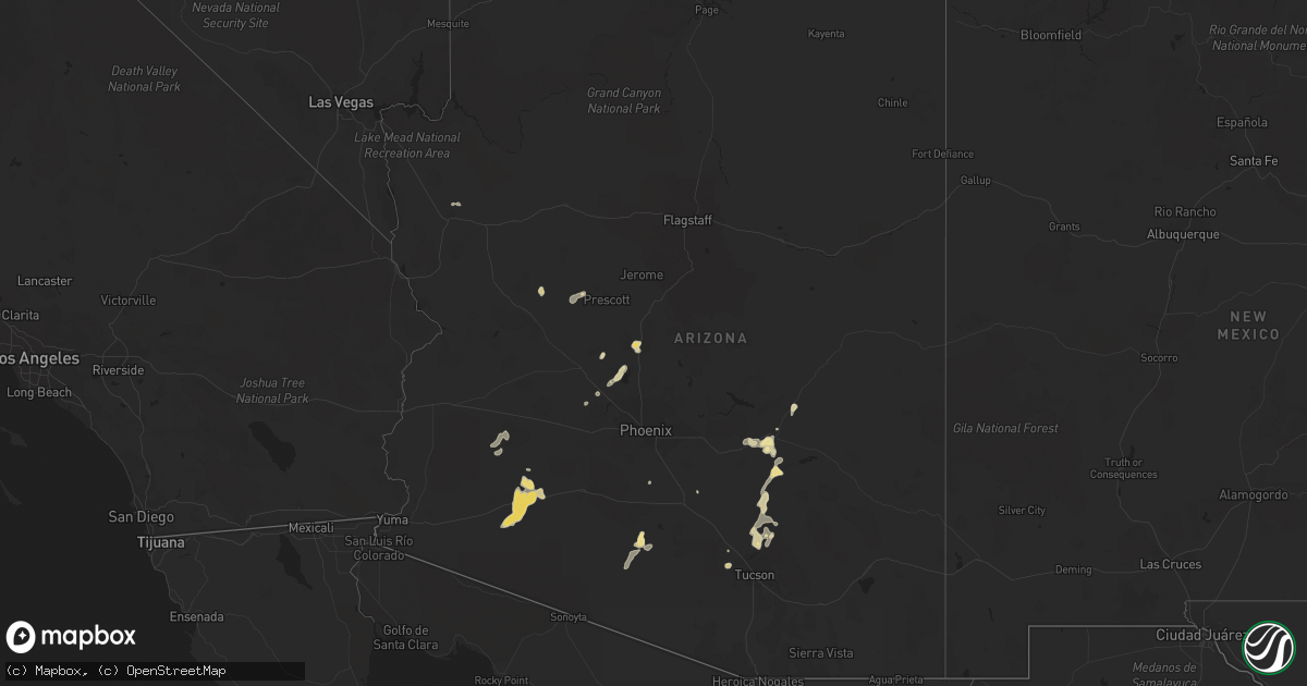
Hail Map in Arizona on August 16, 2020
Get this storm
August 16 map
$229
one time, instant access
Download today. No call, no setup
Keep the $229
Bought the map and want the full workflow? Apply the entire $229 to a subscription within 7 days. None of it is wasted.
Every map, not just this one
This buys you this map. Subscription and you get every map we run, in the markets you choose from a few cities to whole states to nationwide. Plus real-time alerts the moment a storm fires.
Contact data
Name, contact info, occupancy, even credit band for addresses in the footprint. You go from where it hit to who to call.
Become the source they trust
Unlimited branding weather history reports on demand. You already have the documented answer ready for the property owner, and you are the one who showed up with it.
Property data and RoofTrace estimates
Pull up any address you have got, its value and the exact code rules for that jurisdiction, straight from One Click Code. Then RoofTrace estimates the squares, pitch, and roof value, priced the way you price.
Storm reports in Arizona
Arizona
| Date | Description |
|---|---|
| 08/16/20206:53 PM CDT | Mesonet station qspa3 sunset point. |
| 08/16/20206:38 PM CDT | Thunderstorm wind damage to property. Down tree branches... Some roof and siding damage... And estimated wind gust of 64.6 mph on personal weather sensor. |
| 08/16/20204:04 PM CDT | Tree limbs down. Several weather stations in the area recorded gusts 60-68 mph. |
| 08/16/20201:25 AM CDT | At 625 PM MST, a severe thunderstorm was located near Maricopa, or 17 miles southwest of Sun Lakes, moving southwest at 10 mph. HAZARD...60 mph wind gusts. SOURCE...Radar indicated. IMPACT...Expect damage to roofs, siding, and trees. Locations impacted include... Maricopa and Ak-Chin Village. |
| 08/16/20201:15 AM CDT | At 614 PM MST, a severe thunderstorm was located 10 miles southeast of Kaka moving southwest at 30 mph. HAZARD...60 mph wind gusts and quarter size hail. SOURCE...Radar indicated. IMPACT...Hail damage to vehicles is expected. Expect wind damage to roofs, siding, and trees. Locations impacted include... Santa Rosa, Anegam, North Komelik, Kohatk, Palo Verde Stand, Ventana, Vaya Chin, San Luis and Santa Rosa School. |
| 08/16/202012:38 AM CDT | At 537 PM MST, a severe thunderstorm was located 9 miles east of Kaka moving southwest at 25 mph. HAZARD...60 mph wind gusts. SOURCE...Radar indicated. IMPACT...Expect damage to roofs, siding, and trees. Locations impacted include... Santa Rosa, Anegam, North Komelik, Kohatk, Palo Verde Stand, Ventana, Vaya Chin, Jack Rabbit, San Luis and Santa Rosa School. |
| 08/16/202012:35 AM CDT | At 535 PM MST, a severe thunderstorm was located near Lake Pleasant, or 12 miles northeast of Wittmann, moving southwest at 15 mph. HAZARD...60 mph wind gusts and quarter size hail. SOURCE...Radar indicated. IMPACT...Hail damage to vehicles is expected. Expect wind damage to roofs, siding, and trees. Locations impacted include... Lake Pleasant and Vistancia. |
| 08/16/202012:06 AM CDT | At 505 PM MST, a severe thunderstorm was located 8 miles west of Saguaro National Park West, or 13 miles southwest of Marana, moving west at 20 mph. HAZARD...60 mph wind gusts and quarter size hail. Blowing dust with less than one quarter of a mile visibility possible. SOURCE...Radar indicated. IMPACT...Hail damage to vehicles is expected. Expect wind damage to roofs, siding, and trees. Locations impacted include... Marana, Three Points, Avra Valley, Saguaro National Park West, Tucson Estates, Picture Rocks, San Pedro, Pan Tak and Silver Bell.This includes the following highways... Interstate 10 between mile markers 238 and 243. Route 86 between mile markers 132 and 153. Route 286 between mile markers 42 and 45. |
| 08/15/202011:55 PM CDT | At 454 PM MST, a severe thunderstorm was located near Bumble Bee, or 16 miles north of New River, moving southwest at 10 mph. HAZARD...60 mph wind gusts and quarter size hail. SOURCE...Radar indicated. IMPACT...Hail damage to vehicles is expected. Expect wind damage to roofs, siding, and trees. Locations impacted include... Rock Springs, Bumble Bee, Black Canyon City, Turney Gulch Group Campground and Hazlett Hollow Campground. |
| 08/15/202011:25 PM CDT | At 424 PM MST, severe thunderstorms were located along a line extending from near Hayden to near Catalina State Park north of Tucson, moving southwest at 10 to 15 mph. HAZARD...60 mph wind gusts and quarter size hail. SOURCE...Radar indicated. IMPACT...Hail damage to vehicles is expected. Expect wind damage to roofs, siding, and trees. Locations impacted include... Catalina, Oro Valley, Marana, Oracle, Saddlebrooke, Tortolita, Kearny, Dudleyville, Picture Rocks, Oracle Junction, Biosphere 2 and Dove Mountain.This includes the following highways... Interstate 10 between mile markers 241 and 245. Route 77 between mile markers 83 and 101, and near mile marker 134. Route 79 between mile markers 92 and 108. Route 177 between mile markers 139 and 146. |
| 08/15/202011:20 PM CDT | At 419 PM MST, a severe thunderstorm was located near Huachuca City, or 8 miles northwest of Sierra Vista, moving southwest at 20 mph. HAZARD...60 mph wind gusts and quarter size hail. SOURCE...Radar indicated. IMPACT...Hail damage to vehicles is expected. Expect wind damage to roofs, siding, and trees. Locations impacted include... Sierra Vista, Hereford, Whetstone, Huachuca City, Elgin, Fort Huachuca, Parker Canyon Lake, Palominas, Charleston, Canelo, Fairbank, Coronado National Memorial and Ramsey Canyon Preserve.This includes the following highways... Route 82 between mile markers 47 and 64. Route 83 between mile markers 3 and 16. Route 90 between mile markers 306 and 331. Route 92 between mile markers 322 and 345. |
| 08/15/202011:09 PM CDT | At 408 PM MST, a severe thunderstorm was located near Bagdad, or 28 miles east of Wikieup, and is nearly stationary. HAZARD...60 mph wind gusts and quarter size hail. SOURCE...Radar indicated. IMPACT...Hail damage to vehicles is expected. Expect wind damage to roofs, siding, and trees. Locations impacted include... Bagdad. |
| 08/15/202010:57 PM CDT | At 356 PM MST, a severe thunderstorm was located near New Kingman-Butler, or 7 miles northeast of Kingman, moving southwest at 15 mph. HAZARD...60 mph wind gusts and quarter size hail. SOURCE...Radar indicated. IMPACT...Hail damage to vehicles is expected. Expect wind damage to roofs and trees. Locations impacted include... Kingman, Golden Valley and New Kingman-Butler. This includes Interstate 40 in Arizona between mile markers 40 and59. |
| 08/15/202010:53 PM CDT | At 351 PM MST, a severe thunderstorm was located near Catalina, moving southwest at 10 to 15 mph. HAZARD...60 mph wind gusts and quarter size hail. SOURCE...Radar indicated. IMPACT...Hail damage to vehicles is expected. Expect wind damage to roofs, siding, and trees. Locations impacted include... Catalina, Oro Valley, Marana, Northwest Tucson, Casas Adobes, Flowing Wells, Saddlebrooke, Tortolita, Catalina State Park, Catalina Foothills, Dove Mountain, Oracle Junction and Biosphere 2.This includes the following highways... Interstate 10 between mile markers 243 and 255. Route 77 between mile markers 71 and 96. Route 79 between mile markers 92 and 94. |
| 08/15/202010:51 PM CDT | Employee from yuma fd traveling along i-8 reported substantial roof... Tree... And car damage from a collapsing thunderstorm at the sentinel rest area. Wind gusts were |
| 08/15/202010:30 PM CDT | At 330 PM MST, a severe thunderstorm was located near Miami, or near Globe, moving southwest at 15 mph. HAZARD...60 mph wind gusts and quarter size hail. SOURCE...Radar indicated. IMPACT...Hail damage to vehicles is expected. Expect wind damage to roofs, siding, and trees. Locations impacted include... Globe, Superior, Miami, Cutter, Central Heights-Midland City, Top-Of-The-World, Claypool and Inspiration. |
| 08/15/202010:15 PM CDT | At 314 PM MST, a severe thunderstorm was located 7 miles northwest of Skull Valley, or 22 miles west of Prescott Valley, moving southwest at 15 mph. HAZARD...60 mph wind gusts and penny size hail. SOURCE...Radar indicated. IMPACT...Expect damage to roofs, siding, and trees. Locations impacted include... Yava. |
| 08/15/202010:15 PM CDT | At 314 PM MST, a severe thunderstorm was located over Catalina State Park, or over Oro Valley, moving west at 5 to 10 mph. HAZARD...60 mph wind gusts and nickel size hail. SOURCE...Radar indicated. IMPACT...Expect damage to roofs, siding, and trees. Locations impacted include... Northern Tucson, Catalina, Oro Valley, Marana, Casas Adobes, Flowing Wells, Tortolita, Catalina Foothills, Catalina State Park and Dove Mountain.This includes Route 77 between mile markers 70 and 87. |
| 08/15/20207:55 PM CDT | Awos station kavq marana regional airport. |
| 08/15/20207:44 PM CDT | **delayed report**...approximately 20 trees down on golf course with the largest trees 10-12 inches in diameter. Manager also reported additional damage... Including fe |
| 08/15/20207:15 PM CDT | Dime to quarter size hail. |
All States Impacted by Hail Map on August 16, 2020
Cities Impacted by Hail Map on August 16, 2020
- Woodville, TX
- Cleveland, TX
- Liberty, TX
- Camden, MS
- Canton, MS
- New Waverly, TX
- Iowa, LA
- Welsh, LA
- Mullinville, KS
- Greensburg, KS
- Quinlan, TX
- Hoskins, NE
- Winside, NE
- Mclean, TX
- Marietta, OK
- Sun City, KS
- Lake City, KS
- Medicine Lodge, KS
- Coats, KS
- Pratt, KS
- Windthorst, TX
- Bee, NE
- Garland, NE
- Moorefield, NE
- Ringwood, OK
- Meno, OK
- Wittmann, AZ
- Champion, NE
- Clarks, NE
- Central City, NE
- Fullerton, NE
- Genoa, NE
- Silver Creek, NE
- Enid, OK
- Fairmont, OK
- Fort Worth, TX
- Culbertson, NE
- McCook, NE
- Mankato, KS
- Protection, KS
- Ashland, KS
- Natoma, KS
- Nacogdoches, TX
- Palestine, TX
- Frankston, TX
- Rush, CO
- Dallas, TX
- Jayton, TX
- Girard, TX
- Snyder, TX
- Mckinney, TX
- Princeton, TX
- Beaver, OK
- Winters, TX
- Wahoo, NE
- Memphis, NE
- Waverly, NE
- Mead, NE
- Prague, NE
- Colon, NE
- Greenwood, NE
- Ithaca, NE
- Weston, NE
- Malmo, NE
- Morse Bluff, NE
- Yutan, NE
- North Bend, NE
- Ceresco, NE
- Eagle, NE
- Alvo, NE
- Cedar Bluffs, NE
- Ashland, NE
- Glen Elder, KS
- Cawker City, KS
- Canadian, TX
- Sutton, NE
- Edgar, NE
- Helena, OK
- Kaufman, TX
- Kirk, CO
- Ardmore, OK
- Springer, OK
- Alva, OK
- Holyoke, CO
- Wray, CO
- Imperial, NE
- Parks, NE
- Davis, OK
- Lone Grove, OK
- Trinidad, TX
- Red Oak, TX
- Cedar Hill, TX
- Midlothian, TX
- Bellwood, NE
- David City, NE
- Columbus, NE
- Miami, TX
- Amherst, NE
- Royse City, TX
- Caddo Mills, TX
- Hugoton, KS
- Liberal, KS
- Prentiss, MS
- Elm Creek, NE
- Wichita Falls, TX
- Wilson, OK
- Lena, MS
- Forest, MS
- Raleigh, MS
- Eckley, CO
- Idalia, CO
- Sallis, MS
- Deridder, LA
- Alexandria, NE
- Carthage, MS
- Apple Springs, TX
- Crockett, TX
- Moscow, TX
- Livingston, TX
- Elkhart, TX
- Grapeland, TX
- Kennard, TX
- Corrigan, TX
- Alto, TX
- Pollok, TX
- Diboll, TX
- Saratoga, TX
- Wells, TX
- Groveton, TX
- Lufkin, TX
- Matador, TX
- Ringling, OK
- Lake Creek, TX
- Sulphur Bluff, TX
- Murchison, TX
- Athens, TX
- Eustace, TX
- Stratton, NE
- Agenda, KS
- Gibbon, NE
- Minden, NE
- Shelton, NE
- Burlington, OK
- Lone Oak, TX
- Clay Center, KS
- Miltonvale, KS
- Minneapolis, KS
- Whitewright, TX
- Trenton, TX
- Anna, TX
- Van Alstyne, TX
- Melissa, TX
- Celina, TX
- Leonard, TX
- Blue Ridge, TX
- Howe, TX
- Sherman, TX
- Gunter, TX
- Holliday, TX
- Casa Grande, AZ
- Greenville, TX
- Rosston, OK
- Ordway, CO
- Chapman, NE
- Grand Island, NE
- Phillips, NE
- Republican City, NE
- Onaga, KS
- Sawyer, KS
- Alpha, MN
- Sherburn, MN
- Lebanon, KS
- Esbon, KS
- Madison, MS
- Madill, OK
- Aurora, NE
- Marquette, NE
- Hardtner, KS
- Kiowa, KS
- Big Lake, TX
- Brainard, NE
- Benkelman, NE
- Wakefield, NE
- Farnam, NE
- Brady, NE
- Maxwell, NE
- Curtis, NE
- Plano, TX
- Rose Hill, MS
- Funk, NE
- Holdrege, NE
- Pitkin, LA
- Joes, CO
- Vona, CO
- Bethune, CO
- Stratton, CO
- Gaylord, KS
- Turpin, OK
- Scotland, TX
- Archer City, TX
- Kemp, TX
- Scurry, TX
- Van, TX
- Ben Wheeler, TX
- Syracuse, KS
- Coolidge, KS
- Black Canyon City, AZ
- Childress, TX
- Cee Vee, TX
- Seymour, TX
- Blossom, TX
- Oakwood, TX
- Yuma, CO
- Point, TX
- Cumby, TX
- Emory, TX
- Enterprise, MS
- Clarendon, TX
- Belleville, KS
- Palisade, NE
- Malakoff, TX
- Mabank, TX
- Warren, TX
- Leigh, NE
- Clarkson, NE
- Washington, OK
- Blanchard, OK
- Talco, TX
- Natchez, MS
- Ravenna, NE
- Waynoka, OK
- Mineola, TX
- Quitman, TX
- Paducah, TX
- San Manuel, AZ
- Roaring Springs, TX
- Abilene, TX
- Healdton, OK
- Grand Chenier, LA
- Omaha, NE
- Walnut Grove, MS
- Aline, OK
- Rozel, KS
- Larned, KS
- Brownsboro, TX
- Tennessee Colony, TX
- Kingman, AZ
- Garland, TX
- Rowlett, TX
- Granbury, TX
- Lipan, TX
- Tucson, AZ
- Oracle, AZ
- Dwight, NE
- Lincoln, NE
- Avoca, NE
- Milford, NE
- Murdock, NE
- Rogers, NE
- Linwood, NE
- Syracuse, NE
- Dodge, NE
- Ulysses, NE
- Valparaiso, NE
- Seward, NE
- Malcolm, NE
- Unadilla, NE
- Staplehurst, NE
- Elmwood, NE
- Bruno, NE
- Schuyler, NE
- Pleasant Dale, NE
- Denton, NE
- Beloit, KS
- Clinton, MS
- Carson, MS
- Henrietta, TX
- Haviland, KS
- Bruning, NE
- Dateland, AZ
- Elgin, NE
- Petersburg, NE
- Tilden, NE
- Oakdale, NE
- Snyder, NE
- West Point, NE
- Scribner, NE
- Wilmore, KS
- Bells, TX
- Savoy, TX
- Bonham, TX
- Ravenna, TX
- Buckeye, AZ
- Gila Bend, AZ
- Milligan, NE
- Friend, NE
- Fairbury, NE
- Jansen, NE
- Buffalo, OK
- Plevna, KS
- Chase, KS
- Lyons, KS
- Alden, KS
- Sterling, KS
- Abbyville, KS
- Jacksboro, TX
- Alba, TX
- Yantis, TX
- Norfolk, NE
- Madison, NE
- York, NE
- Winona, KS
- Bassfield, MS
- Saint Edward, NE
- Pilot Point, TX
- Hayes Center, NE
- Memphis, TX
- Bolton, MS
- Saint Francis, KS
- Hampton, NE
- Globe, AZ
- Miami, AZ
- Superior, AZ
- Superior, NE
- Hillsboro, TX
- Geneva, NE
- Holly, MI
- Nocona, TX
- Campbell, TX
- Morton, MS
- Geneva, FL
- Oviedo, FL
- Hedley, TX
- Fairfield, NE
- Clay Center, NE
- Deweese, NE
- Carleton, NE
- Oxford, NE
- Beaver City, NE
- Stamford, NE
- Orleans, NE
- Kensington, KS
- Alma, NE
- Naponee, NE
- Edison, NE
- Agra, KS
- Phillipsburg, KS
- Longdale, OK
- Edwards, MS
- Raymond, MS
- Blue Hill, NE
- Lawrence, NE
- Downs, KS
- West, MS
- Kosciusko, MS
- Goodman, MS
- Goltry, OK
- Winkelman, AZ
- Winnsboro, TX
- Cedar Rapids, NE
- Paoli, OK
- Waxahachie, TX
- Italy, TX
- Milford, TX
- Mccomb, MS
- Magnolia, MS
- Lovelady, TX
- Trinity, TX
- Kit Carson, CO
- Hillsboro, OH
- Lynchburg, OH
- Martinsville, OH
- Midland, OH
- Pampa, TX
- Strang, NE
- Shickley, NE
- Denison, TX
- Tyler, TX
- Weatherford, TX
- Meade, KS
- Karval, CO
- Coldwater, KS
- Lane, OK
- Atoka, OK
- Hanover, KS
- Hollenberg, KS
- Fairfield, TX
- Kerens, TX
- Mesquite, TX
- Grand Saline, TX
- Collins, MS
- Ryan, OK
- Ector, TX
- Wolfe City, TX
- Celeste, TX
- Trenton, NE
- Atwood, KS
- Milford, KS
- Drummond, OK
- Waukomis, OK
- Hennessey, OK
- Ames, OK
- Paris, TX
- Cushing, TX
- Douglass, TX
- Green, KS
- Washington, KS
- Narka, KS
- Palmer, KS
- Clifton, KS
- Mahaska, KS
- Haddam, KS
- Linn, KS
- Greenleaf, KS
- Morrowville, KS
- Randolph, KS
- Leonardville, KS
- Ohiowa, NE
- Hebron, NE
- Gilead, NE
- Crete, NE
- Dorchester, NE
- Rusk, TX
- Farmersville, TX
- Nevada, TX
- Indianola, NE
- Maywood, NE
- Whitesboro, TX
- Sadler, TX
- Mount Vernon, TX
- Ferriday, LA
- Congress, AZ
- Electra, TX
- Iowa Park, TX
- Dannebrog, NE
- Wauneta, NE
- Model, CO
- Hordville, NE
- Cairo, NE
- Daykin, NE
- Harvard, NE
- Davenport, NE
- Henderson, NE
- Hubbell, NE
- Fairmont, NE
- Bradshaw, NE
- Exeter, NE
- Reynolds, NE
- Clyde, KS
- Oak, NE
- Polk, NE
- Western, NE
- Giltner, NE
- Glenvil, NE
- Tobias, NE
- Saronville, NE
- Ong, NE
- Inland, NE
- Saint Libory, NE
- Alda, NE
- McCool Junction, NE
- Nelson, NE
- Utica, MS
- Leesville, LA
- Coldspring, TX
- Sugar City, CO
- Arlington, CO
- Hunter, KS
- Collinsville, TX
- Gainesville, TX
- Walsenburg, CO
- Mooreland, OK
- Windom, TX
- Honey Grove, TX
- Huntsville, TX
- Aubrey, TX
- Groesbeck, TX
- Bird City, KS
- Morristown, AZ
- Rocky Ford, CO
- Manzanola, CO
- Kismet, KS
- Kearney, NE
- Gate, OK
- Lorman, MS
- Dover, OK
- Tipton, KS
- Osborne, KS
- Jacksonville, TX
- Cleo Springs, OK
- Turkey, TX
- Beaver Crossing, NE
- Waco, NE
- Pelahatchie, MS
- Brandon, MS
- Belpre, KS
- Lewis, KS
- Byers, KS
- Garfield, KS
- Spur, TX
- Dickens, TX
- Lelia Lake, TX
- Vaughan, MS
- Millsap, TX
- Onalaska, TX
- Carmen, OK
- Max, NE
- Hineston, LA
- Boise City, OK
- Lindsay, OK
- Ringgold, TX
- Bellevue, TX
- Grand Prairie, TX
- Abbott, TX
- Kinder, LA
- Canton, TX
- Tenaha, TX
- Itasca, TX
- Lancaster, TX
- Desoto, TX
- Jackson, MS
- Frankfort, KS
- Lebanon, NE
- Perryton, TX
- Cooper, TX
- Ben Franklin, TX
- Montalba, TX
- Pauls Valley, OK
- Maysville, OK
- Crowell, TX
- Burneyville, OK
- Overbrook, OK
- Justiceburg, TX
- Ackerman, MS
- Weir, MS
- Venus, TX
- Norton, KS
- Larue, TX
- Peshtigo, WI
- Marinette, WI
- Barnes, KS
- Ayr, NE
- Saint Jo, TX
- Leon, OK
- Muenster, TX
- Bloomington, NE
- Kirkland, AZ
- Port Gibson, MS
- Hermanville, MS
- Vicksburg, MS
- Bennington, KS
- Pachuta, MS
- Luray, KS
- Kingston, OK
- Grandview, TX
- Rugby, ND
- Creston, NE
- Goodland, KS
- Sanger, TX
- Sulphur, OK
- Ames, NE
- Fremont, NE
- Morganville, KS
- Addison, TX
- Burkburnett, TX
- Wilsonville, NE
- Powderly, TX
- Sells, AZ
- Cameron, LA
- Livonia, MI
- Shubuta, MS
- Terral, OK
- Mendenhall, MS
- Magee, MS
- Fairview, OK
- McDonald, KS
- Forgan, OK
- Dougherty, OK
- Albion, NE
- Smith Center, KS
- Burr Oak, KS
- Lake, MS
- Pulaski, MS
- Benedict, NE
- Stromsburg, NE
- Hermleigh, TX
- Marana, AZ
- Davisburg, MI
- Bogue, KS
- Hill City, KS
- Hazelton, KS
- Roll, AZ
- Louisville, MS
- Doniphan, NE
- Wood River, NE
- Bailey, TX
- Tioga, TX
- Allen, TX
- Gordonville, TX
- Valley View, TX
- Trimont, MN
- Welcome, MN
- Vossburg, MS
- Aspermont, TX
- Monticello, MS
- Danbury, NE
- Peoria, AZ
- Prescott, AZ
- Lee Vining, CA
- Denton, TX
- Tampa, KS
- Mathiston, MS
- Raymond, NE
- Palmyra, NE
- Battle Creek, NE
- Stanton, NE
- Howells, NE
- Weeping Water, NE
- Abie, NE
- Haigler, NE
- Selden, KS
- Dresden, KS
- Plainville, KS
- Boelus, NE
- Chandler, TX
- Hendley, NE
- Plains, KS
- Homer, NE
- Hubbard, NE
- Quanah, TX
- Detroit, TX
- Dike, TX
- Saltillo, TX
- Newman Grove, NE
- Clearwater, NE
- Pickens, MS
- Flowood, MS
- Chunky, MS
- Hawkins, TX
- Jackson, KY
- Wayne, OK
- Riley, KS
- Belgrade, NE
- Endicott, NE
- Cuba, KS
- Webber, KS
- Plymouth, NE
- Hastings, NE
- Maricopa, AZ
- Conroe, TX
- Thompsons Station, TN
- Ragley, LA
- Houlka, MS
- Pontotoc, MS
- Bertrand, NE
- Jasper, TX
- Houston, MS
- Scroggins, TX
- Kingwood, TX
- Mill Creek, OK
- Fowler, KS
- Louin, MS
- Heidelberg, MS
- Carrollton, TX
- Vermillion, KS
- Bentonia, MS
- Allen, NE
- Dixon, NE
- Reeves, LA
- Enders, NE
- Morland, KS
- Ridgeland, MS
- Diller, NE
- Steele City, NE
- Hull, TX
- Minneola, KS
- Moorefield, KY
- Ewing, KY
- Englewood, KS
- Fort Towson, OK
- Dayton, TX
- Carrier, OK
- Willis, TX
- Akron, CO
- Findlay, OH
- Irving, TX
- Commerce, TX
- Perrin, TX
- Richardson, TX
- Joaquin, TX
- Bingham Lake, MN
- Clarkston, MI
- La Salle, CO
- Newton, MS
- Philadelphia, MS
- Osyka, MS
- Liberty, MS
- Nekoma, KS
- Hendrix, OK
- Elkhorn, NE
- Waterloo, NE
- Centerville, TX
- Maben, MS
- Campbell, NE
- Freedom, OK
- Oakhurst, TX
- Burchard, NE
- Beattie, KS
- Summerfield, KS
- Liberty, NE
- Oketo, KS
- Wills Point, TX
- Woodward, OK
- Peridot, AZ
- Pointblank, TX
- Davey, NE
- Walton, NE
- Lumberton, MS
- Foxworth, MS
- Purvis, MS
- Carriere, MS
- Franklinton, LA
- Angie, LA
- Tylertown, MS
- Bogalusa, LA
- Sumrall, MS
- Columbia, MS
- Hattiesburg, MS
- Mount Olive, MS
- Sandy Hook, MS
- Poplarville, MS
- Wynnewood, OK
- Bartley, NE
- Mobeetie, TX
- Wellington, TX
- Lakeview, TX
- Thackerville, OK
- Hurst, TX
- Era, TX
- Lindsay, TX
- Krum, TX
- Keller, TX
- Decatur, TX
- Grapevine, TX
- Southlake, TX
- Roanoke, TX
- Arlington, TX
- Euless, TX
- Lewisville, TX
- Argyle, TX
- Bedford, TX
- Flower Mound, TX
- Coppell, TX
- Colleyville, TX
- Gould, OK
- Vernon, TX
- Odell, TX
- Newcastle, TX
- Olney, TX
- Sheppard Afb, TX
- Sharon Springs, KS
- Wallace, KS
- Edson, KS
- Leoti, KS


