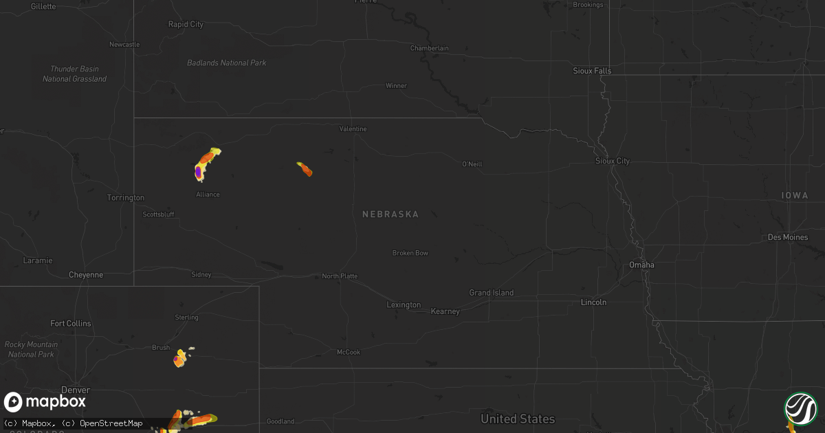
Hail Map in Nebraska on August 15, 2020
Get this storm
August 15 map
$229
one time, instant access
Download today. No call, no setup
Keep the $229
Bought the map and want the full workflow? Apply the entire $229 to a subscription within 7 days. None of it is wasted.
Every map, not just this one
This buys you this map. Subscription and you get every map we run, in the markets you choose from a few cities to whole states to nationwide. Plus real-time alerts the moment a storm fires.
Contact data
Name, contact info, occupancy, even credit band for addresses in the footprint. You go from where it hit to who to call.
Become the source they trust
Unlimited branding weather history reports on demand. You already have the documented answer ready for the property owner, and you are the one who showed up with it.
Property data and RoofTrace estimates
Pull up any address you have got, its value and the exact code rules for that jurisdiction, straight from One Click Code. Then RoofTrace estimates the squares, pitch, and roof value, priced the way you price.
Storm reports in Nebraska
Nebraska
| Date | Description |
|---|---|
| 08/15/20204:35 PM CDT | Trained spotter reports hail stone of approximately 3.25 inch in diameter. |
| 08/15/20204:29 PM CDT | A local report indicates 2.75 inch wind near 4 NE HEMINGFORD |
| 08/15/20203:21 PM CDT | A local report indicates 1.00 inch wind near 11 E CHADRON STATE PARK |
| 08/15/20202:32 PM CDT | Half dollar hail and torrential rain |
| 08/14/202010:21 PM CDT | At 320 PM MDT, a severe thunderstorm was located 21 miles south of Medicine Lake, or 30 miles northwest of Mullen, moving east at 15 mph. HAZARD...Ping pong ball size hail. SOURCE...Radar indicated. IMPACT...People and animals outdoors will be injured. Expect damage to roofs, siding, windows, and vehicles. Locations impacted include... Sevenmile Hill, Highway 97 crossing the North Loup River and Speckel Meir Lake.This includes Highway 97 between mile markers 91 and 96. |
| 08/14/202010:16 PM CDT | At 316 PM MDT, a severe thunderstorm was located near Box Butte Dam, or 21 miles north of Alliance, moving southwest at 15 mph. HAZARD...60 mph wind gusts and half dollar size hail. SOURCE...Radar indicated. IMPACT...Hail damage to vehicles is expected. Expect wind damage to roofs, siding, and trees. This severe thunderstorm will be near... Hemingford around 340 PM MDT. |
| 08/14/20209:41 PM CDT | At 240 PM MDT, a severe thunderstorm was located 8 miles east of Box Butte Dam, or 17 miles southwest of Hay Springs, moving southwest at 15 to 20 mph. HAZARD...Golf ball size hail and 60 mph wind gusts. SOURCE...Radar indicated. IMPACT...People and animals outdoors will be injured. Expect hail damage to roofs, siding, windows, and vehicles. Expect wind damage to roofs, siding, and trees. This severe thunderstorm will be near... Box Butte Dam around 305 PM MDT. |
| 08/14/20209:06 PM CDT | At 205 PM MDT, a severe thunderstorm was located 7 miles southwest of Hay Springs, moving southwest at 5 to 10 mph. HAZARD...Ping pong ball size hail and 60 mph wind gusts. SOURCE...Radar indicated. IMPACT...People and animals outdoors will be injured. Expect hail damage to roofs, siding, windows, and vehicles. Expect wind damage to roofs, siding, and trees. This severe thunderstorm will remain over mainly rural areas of northeastern Box Butte and southeastern Dawes Counties. |
| 08/14/20208:29 PM CDT | At 128 PM MDT, a severe thunderstorm was located 7 miles south of Hay Springs, and is nearly stationary. HAZARD...Ping pong ball size hail and 60 mph wind gusts. SOURCE...Radar indicated. IMPACT...People and animals outdoors will be injured. Expect hail damage to roofs, siding, windows, and vehicles. Expect wind damage to roofs, siding, and trees. Locations impacted include... Intersection of Highway 87 and Antelope Road and Walgren Lake State Recreation Area. |
All States Impacted by Hail Map on August 15, 2020
Cities Impacted by Hail Map on August 15, 2020
- Hugo, CO
- Joplin, MO
- Riverton, KS
- Treece, KS
- Carl Junction, MO
- Quapaw, OK
- Picher, OK
- Baxter Springs, KS
- Miami, OK
- Columbus, KS
- Galena, KS
- Sells, AZ
- Bartlesville, OK
- New Llano, LA
- Leesville, LA
- East China, MI
- Waverly, MO
- Dewey, OK
- Vinita, OK
- Akron, CO
- Independence, WI
- Eleva, WI
- Seibert, CO
- Flagler, CO
- Arriba, CO
- Farwell, MI
- Harrison, MI
- Clare, MI
- Genoa, CO
- Lincoln, KS
- Ellsworth, KS
- Sylvan Grove, KS
- Hay Springs, NE
- Cheneyville, LA
- Ville Platte, LA
- Hemingford, NE
- Groom, TX
- Panhandle, TX
- Crosbyton, TX
- Casco, MI
- Columbus, MI
- Limon, CO
- Welch, OK
- Clinton, MO
- Colorado Springs, CO
- Kingsville, MO
- Kress, TX
- Bluejacket, OK
- Monument, CO
- Galena, IL
- Hanover, IL
- Elizabeth, IL
- Nowata, OK
- Ochelata, OK
- Barnsdall, OK
- Skiatook, OK
- Ramona, OK
- Delaware, OK
- Clear Lake, WI
- Lenapah, OK
- Protection, KS
- Webb City, MO
- Deepwater, MO
- Huachuca City, AZ
- Alliance, NE
- Benson, AZ
- Silverton, TX
- Scotts, MI
- Kalamazoo, MI
- Tulia, TX
- Diamond, MO
- Carthage, MO
- Mondovi, WI
- Reed City, MI
- Isabel, KS
- Valentine, NE
- Claude, TX
- Pineville, LA
- Colfax, LA
- Clyde, TX
- Coffeyville, KS
- S Coffeyville, OK
- Howell, MI
- Milnesand, NM
- Fowler, IN
- Edwardsville, IL
- Troy, IL
- Sonoita, AZ
- Trementina, NM
- Whitehall, WI
- Garita, NM
- Weir, KS
- Oronogo, MO
- Commerce, OK
- Chelsea, OK
- Lockney, TX
- Bates City, MO
- Holden, MO
- Lone Jack, MO
- Odessa, MO
- Blair, WI
- Ettrick, WI
- Malta Bend, MO
- North Miami, OK
- Afton, OK
- Medicine Lodge, KS
- Sharon, KS
- Pawhuska, OK
- Boyceville, WI
- Prairie Farm, WI
- Morton, TX
- Sudan, TX
- Maple, TX
- Bartlett, KS
- Edna, KS
- Beaverton, MI
- Earl Park, IN
- Tucson, AZ
- Chilhowee, MO
- Blairstown, MO
- Chase, MI
- Chetopa, KS
- Tererro, NM
- Pecos, NM
- White Deer, TX
- Norborne, MO
- Ashland, KS
- Cass City, MI
- Elgin, AZ
- Coldwater, KS
- Boswell, IN
- Shafer, MN
- Snyder, TX
- Urich, MO
- Chadron, NE
- Vona, CO
- Carrollton, MO


