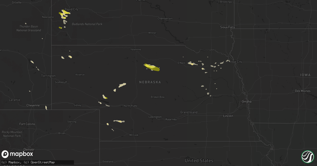
Hail Map in Nebraska on August 15, 2016
Get this storm
August 15 map
$229
one time, instant access
Download today. No call, no setup
Keep the $229
Bought the map and want the full workflow? Apply the entire $229 to a subscription within 7 days. None of it is wasted.
Every map, not just this one
This buys you this map. Subscription and you get every map we run, in the markets you choose from a few cities to whole states to nationwide. Plus real-time alerts the moment a storm fires.
Contact data
Name, contact info, occupancy, even credit band for addresses in the footprint. You go from where it hit to who to call.
Become the source they trust
Unlimited branding weather history reports on demand. You already have the documented answer ready for the property owner, and you are the one who showed up with it.
Property data and RoofTrace estimates
Pull up any address you have got, its value and the exact code rules for that jurisdiction, straight from One Click Code. Then RoofTrace estimates the squares, pitch, and roof value, priced the way you price.
Storm reports in Nebraska
Nebraska
| Date | Description |
|---|---|
| 08/15/201612:40 AM CDT | Law enforcement reported dime to quarter size hail and high winds. Parts of ogallala without power |
| 08/14/201610:15 PM CDT | A local report indicates 58 MPH wind near ALLIANCE |
| 08/14/20169:47 PM CDT | Half dollar size hail with pea size hail... Covered the ground. |
All States Impacted by Hail Map on August 15, 2016
Cities Impacted by Hail Map on August 15, 2016
- Flintstone, MD
- Little Orleans, MD
- Doswell, VA
- Beaverdam, VA
- Ashland, VA
- Columbia, NC
- Walton, WV
- Clendenin, WV
- Lemoyne, NE
- Arthur, NE
- Newburg, WV
- Bowdle, SD
- Cross Junction, VA
- Berkeley Springs, WV
- Gladstone, VA
- Benkelman, NE
- Plaza, ND
- Holly Hill, SC
- Brunswick, NE
- Page, NE
- Royal, NE
- Winnetoon, NE
- Orchard, NE
- Beulah, ND
- Richardton, ND
- Boston, VA
- Hill City, SD
- Mullen, NE
- Tryon, NE
- Culpeper, VA
- Eagle Butte, SD
- Gettysburg, SD
- Hampden, ND
- Alsen, ND
- Gore, VA
- Westfield, IA
- Soperton, GA
- Winside, NE
- Hoskins, NE
- Big Springs, NE
- Lewellen, NE
- Makoti, ND
- Ryder, ND
- Selby, SD
- Plainview, NE
- Osmond, NE
- Bumpass, VA
- Partlow, VA
- Ainsworth, NE
- Long Pine, NE
- Johnstown, NE
- Glenham, SD
- Java, SD
- Roscoe, SD
- Hoven, SD
- Tolstoy, SD
- Buffalo, WY
- Imperial, NE
- Newman Grove, NE
- Lindsay, NE
- Independence, WV
- Grafton, WV
- Poolesville, MD
- Germantown, MD
- Carson, ND
- Egeland, ND
- Esmont, VA
- Schuyler, VA
- Howardsville, VA
- Buckingham, VA
- Gum Spring, VA
- Mineral, VA
- Maidens, VA
- Crozier, VA
- Goochland, VA
- Glenburn, ND
- Ferrum, VA
- Rocky Mount, VA
- Henry, VA
- Saint Francis, KS
- Pollock, SD
- Limestone, TN
- Fall Branch, TN
- Jonesborough, TN
- Coachella, CA
- Stanley, ND
- Ross, ND
- Westhope, ND
- Souris, ND
- Winchester, VA
- Sutherland, NE
- Bonifay, FL
- Palmyra, VA
- Scottsville, VA
- Tarrytown, GA
- Allen, NE
- Bloomfield, NE
- Bassett, NE
- Weston, WV
- Lovettsville, VA
- Golden Valley, ND
- Custer, SD
- Hermosa, SD
- Crawford, NE
- Glendo, WY
- Hahira, GA
- Wakpala, SD
- Stafford, VA
- Fredericksburg, VA
- Union Center, SD
- Whitney, NE
- Ruckersville, VA
- Earlysville, VA
- Dyke, VA
- Free Union, VA
- Stanardsville, VA
- Blanchester, OH
- Clarksville, OH
- Richmond, VA
- Chester, VA
- Henrico, VA
- Starkweather, ND
- Clarksburg, WV
- Gibson Island, MD
- Pasadena, MD
- Berthold, ND
- Lansford, ND
- Maxbass, ND
- Laurel, MD
- Carpenter, WY
- Lyons, GA
- Des Lacs, ND
- Geneva, AL
- Coleridge, NE
- Randolph, NE
- Belden, NE
- West Union, OH
- Peebles, OH
- Halliday, ND
- Rapid City, SD
- Wilmington, OH
- Crown City, OH
- Lesage, WV
- Clear Brook, VA
- Humphrey, NE
- Edinburg, VA
- Fort Valley, VA
- Woodstock, VA
- Maurertown, VA
- Onaka, SD
- Powhatan, VA
- Valdosta, GA
- Knoxville, MD
- Brunswick, MD
- Munich, ND
- Wingina, VA
- Pamplin, VA
- Hepzibah, WV
- Shinnston, WV
- Bridgeport, WV
- Meadowbrook, WV
- Washington, DC
- Pierce, NE
- Colonial Heights, VA
- Windsor, VA
- Suffolk, VA
- Keystone, SD
- Charles Town, WV
- Shipman, VA
- Bremo Bluff, VA
- Waverly, VA
- Westville, FL
- Payson, AZ
- Hazen, ND
- Chesapeake, VA
- Dodge, ND
- Quitman, GA
- Morven, GA
- Frazer, MT
- New Enterprise, PA
- Loysburg, PA
- Bedford, PA
- Rixeyville, VA
- Newburg, ND
- Morrow, OH
- Hayes Center, NE
- New Market, VA
- Louisville, GA
- Laurel, NE
- Timberville, VA
- Show Low, AZ
- Sterling, VA
- Fulks Run, VA
- Catlett, VA
- Midland, VA
- Quantico, VA
- Wauneta, NE
- Elsie, NE
- Berryville, VA
- Champion, NE
- Dixon, NE
- Rockville, MD
- Derwood, MD
- Silver Spring, MD
- Olney, MD
- Purcellville, VA
- Bowling Green, VA
- Milford, VA
- Buffalo Gap, SD
- Ogallala, NE
- Columbus, NE
- Baxley, GA
- Alice, TX
- Concepcion, TX
- Jay Em, WY
- Fort Laramie, WY
- Basye, VA
- Sandy Spring, MD
- Mandaree, ND
- Gillette, WY
- Madison, VA
- Pratts, VA
- Rochelle, VA
- Quicksburg, VA
- Platte Center, NE
- Monroe, NE
- Northwood, ND
- Hancock, MD
- Frederick, MD
- Adamstown, MD
- Leesburg, VA
- Point Of Rocks, MD
- Beallsville, MD
- Tuscarora, MD
- Jefferson, MD
- Dickerson, MD
- Victoria, VA
- Oilville, VA
- Sandy Hook, VA
- Mount Rainier, MD
- Hyattsville, MD
- Zap, ND
- Marbury, MD
- Woodbridge, VA
- Indian Head, MD
- Accokeek, MD
- Dumfries, VA
- La Plata, MD
- Bryans Road, MD
- Amelia Court House, VA
- Ponca, NE
- Waterbury, NE
- Prospect, VA
- Cullen, VA
- Herreid, SD
- Barney, GA
- Roanoke, VA
- Wrens, GA
- Ashburn, VA
- Boyds, MD
- Gaithersburg, MD
- Great Falls, VA
- Potomac, MD
- Chuckey, TN
- Friendsville, MD
- Creighton, NE
- Idalia, CO
- Enders, NE
- Langdon, ND
- Montross, VA
- Colonial Beach, VA
- Manquin, VA
- Kit Carson, CO
- Oneill, NE
- Keysville, GA
- Edmore, ND
- Carroll, NE
- Horner, WV
- Brentwood, MD
- Takoma Park, MD
- Wayne, NE
- Wakefield, NE
- Argillite, KY
- Strasburg, ND
- Hague, ND
- Burlington, ND
- Minot, ND
- Clarkson, NE
- Reva, VA
- Sperryville, VA
- Brandy Station, VA
- Taylor, ND
- Nanjemoy, MD
- Hot Springs, SD
- Jackson, NE
- Rocklake, ND
- Ivor, VA
- Riverton, WV
- McIntosh, SD
- Harpers Ferry, WV
- Millville, WV
- Summit Point, WV
- Ranson, WV
- Cheyenne, WY
- Lawton, IA
- Troy, VA
- Timber Lake, SD
- Hartville, WY
- Scottown, OH
- Proctorville, OH
- Chesapeake, OH
- Appomattox, VA
- Jetersville, VA
- Ashton, MD
- Spencerville, MD
- Brookeville, MD
- Moville, IA
- Woodville, VA
- Castleton, VA
- Washington, VA
- Leigh, NE
- High View, WV
- Montpelier, VA
- Brightwood, VA
- Bentonville, VA
- Oakpark, VA
- Aroda, VA
- Parkersburg, WV
- McLaughlin, SD
- Springfield, WV
- Romney, WV
- Harrison, NE
- Lance Creek, WY
- Burtonsville, MD
- Fulton, MD
- Highland, MD
- Beltsville, MD
- Crozet, VA
- Webster, ND
- Brule, NE
- Mitchells, VA
- Rapidan, VA
- Great Cacapon, WV
- Farmville, VA
- Ruther Glen, VA


