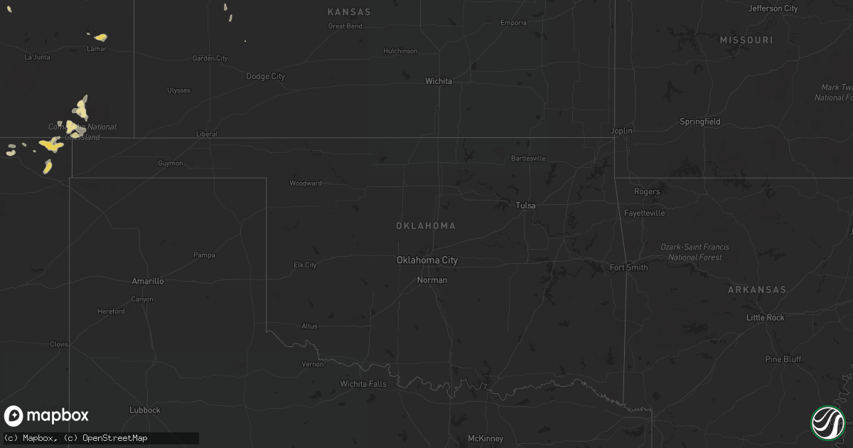
Hail Map in Nebraska on August 13, 2015
Get this storm
August 13 map
$229
one time, instant access
Download today. No call, no setup
Keep the $229
Bought the map and want the full workflow? Apply the entire $229 to a subscription within 7 days. None of it is wasted.
Every map, not just this one
This buys you this map. Subscription and you get every map we run, in the markets you choose from a few cities to whole states to nationwide. Plus real-time alerts the moment a storm fires.
Contact data
Name, contact info, occupancy, even credit band for addresses in the footprint. You go from where it hit to who to call.
Become the source they trust
Unlimited branding weather history reports on demand. You already have the documented answer ready for the property owner, and you are the one who showed up with it.
Property data and RoofTrace estimates
Pull up any address you have got, its value and the exact code rules for that jurisdiction, straight from One Click Code. Then RoofTrace estimates the squares, pitch, and roof value, priced the way you price.
Storm reports in Nebraska
Nebraska
| Date | Description |
|---|---|
| 08/13/20156:42 PM CDT | A local report indicates 60 MPH wind near 5 S THEDFORD |
| 08/13/20156:41 PM CDT | A local report indicates 60 MPH wind near 5 S THEDFORD |
| 08/13/20156:30 PM CDT | 6 inch diameter trees limbs down over the highway along with dime size hail. |
| 08/13/20155:40 PM CDT | A local report indicates 1.00 inch wind near 6 WSW BROWNLEE |
| 08/12/201510:15 PM CDT | Corn stripped from wind driven hail. Estimated wind speed of 60 to 70 mph and hail up to quarter size |
| 08/12/201510:00 PM CDT | In addition to the strong winds... Nickel size hail was falling. |
| 08/12/20159:24 PM CDT | Report of power out across city of north platte and power lines down. |
| 08/12/20159:12 PM CDT | Tree branches down... Some 6 to 8 inches in diameter. Live power lines down. Large tree split in half from wind. |
| 08/12/20159:09 PM CDT | A local report indicates 1.25 inch wind near HERSHEY |
| 08/12/20159:09 PM CDT | A local report indicates 60 MPH wind near HERSHEY |
| 08/12/20159:00 PM CDT | A local report indicates 60 MPH wind near 11 NE WELLFLEET |
| 08/12/20158:58 PM CDT | Trees down on west 1st street in north platte. |
| 08/12/20158:46 PM CDT | A local report indicates 60 MPH wind near 8 SW NORTH PLATTE |
| 08/12/20158:29 PM CDT | A local report indicates 1.75 inch wind near S NORTH PLATTE |
| 08/12/20158:29 PM CDT | A local report indicates 70 MPH wind near S NORTH PLATTE |
| 08/12/20158:28 PM CDT | A local report indicates 1.50 inch wind near 7 N NORTH PLATTE |
| 08/12/20158:28 PM CDT | A local report indicates 60 MPH wind near 7 N NORTH PLATTE |
| 08/12/20158:27 PM CDT | Golf ball size hail measured at the nws office. |
| 08/12/20158:26 PM CDT | A local report indicates 60 MPH wind near NORTH PLATTE |
| 08/12/20158:25 PM CDT | A local report indicates 65 MPH wind near NORTH PLATTE |
| 08/12/20157:56 PM CDT | A local report indicates 2.00 inch wind near 15 N NORTH PLATTE |
| 08/12/20157:44 PM CDT | A local report indicates 1.00 inch wind near 1 N RINGGOLD |
| 08/12/20157:39 PM CDT | A local report indicates 1.00 inch wind near 15 N NORTH PLATTE |
| 08/12/20157:05 PM CDT | Estimated 60 mph wind gust. Numerous 6 to 8 inch long tree branches down and pea size hail. |
| 08/12/20157:00 PM CDT | A local report indicates 2.50 inch wind near 8 WSW STAPLETON |
All States Impacted by Hail Map on August 13, 2015
Cities Impacted by Hail Map on August 13, 2015
- Pritchett, CO
- Long Pine, NE
- Herndon, KS
- Pound, WI
- Arapahoe, NE
- Culbertson, NE
- Stapleton, NE
- Tryon, NE
- Curtis, NE
- Indianola, NE
- Wellfleet, NE
- North Platte, NE
- Maywood, NE
- Maxwell, NE
- Thedford, NE
- Folsom, NM
- Ainsworth, NE
- McCook, NE
- Oberlin, KS
- Edison, NE
- Jackson, GA
- Kit Carson, CO
- Wiley, CO
- Arnold, NE
- Henderson, NV
- Hershey, NE
- Coleman, WI
- Butler, GA
- Lamar, CO
- Healy, KS
- Des Moines, NM
- Capulin, NM
- Beaver City, NE
- Johnstown, NE
- Rush, CO
- Danbury, NE
- Hoxie, KS
- Selden, KS
- Seneca, NE
- Grenville, NM
- Hayes Center, NE
- Brewster, NE
- Dickens, NE
- Nashville, GA
- Holly, CO
- Springfield, CO
- Valentine, NE
- Live Oak, FL
- Silver Springs, FL
- Kissimmee, FL
- Cozad, NE
- Sycamore, GA
- Rebecca, GA
- Jasper, FL
- Alachua, FL
- West Palm Beach, FL
- Wellington, FL
- American Falls, ID
- O'Brien, FL
- Mayo, FL
- Ellaville, GA
- Reynolds, GA
- Roberta, GA
- Stockville, NE
- Fellsmere, FL
- Lake Wales, FL
- Nalcrest, FL
- Micanopy, FL
- Jupiter, FL
- Jennings, KS
- Zolfo Springs, FL
- Coolidge, GA
- Black River Falls, WI
- Lena, WI
- Hawthorne, FL
- Okeechobee, FL
- Orlando, FL
- Brady, NE
- Fort Pierce, FL
- Farnam, NE
- Belle Glade, FL
- Clewiston, FL
- McAlpin, FL
- North Palm Beach, FL
- Palm Beach Gardens, FL
- Hankinson, ND
- Middleburg, FL
- Du Pont, GA
- Suring, WI
- Haines City, FL
- Miami, FL
- Campo, CO
- Kenton, OK
- High Springs, FL
- Lake Butler, FL
- Ocala, FL
- Callaway, NE
- Homerville, GA
- Dighton, KS
- Wilton, WI
- Kendall, WI
- Leakey, TX
- Bassett, NE
- Gothenburg, NE
- Eustis, NE
- Fitzgerald, GA
- Titusville, FL
- Cimarron, KS
- Sparta, WI
- Branford, FL
- Immokalee, FL
- Dunning, NE
- Purdum, NE


