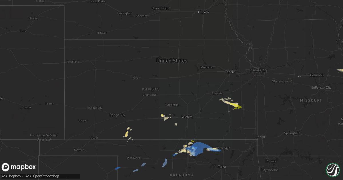
Hail Map in Kansas on August 12, 2019
Get this storm
August 12 map
$229
one time, instant access
Download today. No call, no setup
Keep the $229
Bought the map and want the full workflow? Apply the entire $229 to a subscription within 7 days. None of it is wasted.
Every map, not just this one
This buys you this map. Subscription and you get every map we run, in the markets you choose from a few cities to whole states to nationwide. Plus real-time alerts the moment a storm fires.
Contact data
Name, contact info, occupancy, even credit band for addresses in the footprint. You go from where it hit to who to call.
Become the source they trust
Unlimited branding weather history reports on demand. You already have the documented answer ready for the property owner, and you are the one who showed up with it.
Property data and RoofTrace estimates
Pull up any address you have got, its value and the exact code rules for that jurisdiction, straight from One Click Code. Then RoofTrace estimates the squares, pitch, and roof value, priced the way you price.
Storm reports in Kansas
Kansas
| Date | Description |
|---|---|
| 08/12/20197:32 AM CDT | At 1232 AM CDT, severe thunderstorms were located along a line extending from near Cawker City to near Lucas, moving east at 40 mph. HAZARD...60 mph wind gusts. SOURCE...Radar indicated. IMPACT...Expect damage to roofs, siding, and trees. Locations impacted include... Beloit, Osborne, Downs, Cawker City, Glen Elder, Jewell, Tipton, Portis, Asherville, Simpson, Ionia, Randall, Hunter, Scottsville and Victor. |
| 08/12/20196:28 AM CDT | At 1125 PM CDT, there were 2 severe thunderstorms. One was located very close to Moran while the second was located over Iola. Both severe thunderstorms were moving east at 30 mph and have had a history of producing quarter-sized hail and 60 to 70 mph winds. HAZARD...70 mph wind gusts and quarter size hail. SOURCE...Radar indicated. IMPACT...Hail damage to vehicles is expected. Expect considerable tree damage. Wind damage is also likely to mobile homes, roofs, and outbuildings. Locations impacted include... Iola, Humboldt, La Harpe, Gas, Moran, Savonburg, Elsmore, Mildred, Bassett and Iola Airport. |
| 08/12/20196:13 AM CDT | At 1113 PM CDT, a severe thunderstorm was located near Moran, or near La Harpe, moving east at 30 mph. HAZARD...60 mph wind gusts and quarter size hail. SOURCE...Radar indicated. IMPACT...Hail damage to vehicles is expected. Expect wind damage to roofs, siding, and trees. Locations impacted include... Fort Scott... Marmaton... Bronson... Uniontown... Fulton... Redfield... Mapleton... Harding... Pawnee Station... Hiattville... Petersburg... Hammond... Devon... Porterville... Xenia... |
| 08/12/20195:25 AM CDT | At 1022 PM CDT, a severe thunderstorm was located near Le Roy, or 12 miles southeast of Burlington, moving east southeast at 40 mph. HAZARD...60 mph wind gusts and half dollar size hail. SOURCE...Radar indicated. IMPACT...Hail damage to vehicles is expected. Expect wind damage to roofs, siding, and trees. Locations impacted include... Iola, La Harpe, Gas, Moran, Neosho Falls, Mildred, Bassett and Piqua. |
| 08/12/20195:08 AM CDT | At 1008 PM CDT, a severe thunderstorm was located 4 miles northwest of Le Roy, moving east at 25 mph. HAZARD...Half dollar size hail. SOURCE...Radar indicated. IMPACT...Damage to vehicles is expected. Locations impacted include... Burlington, Colony, Westphalia, Kincaid, Lone Elm and Le Roy. |
| 08/12/20195:05 AM CDT | At 1005 PM CDT, a severe thunderstorm was located over Kingman, moving east at 40 mph. HAZARD...60 mph wind gusts and half dollar size hail. SOURCE...Radar indicated. IMPACT...Hail damage to vehicles is expected. Expect wind damage to roofs, siding, and trees. Locations impacted include... Wichita, Goddard, Kingman, Clearwater, Cheney, Conway Springs, Garden Plain, Norwich, Viola, West Wichita, Eisenhower National Airport, Murdock, Waterloo, Cleveland, Cheney Lake, Mt Vernon, Kingman Airport, Lake Afton, Rago and Cheney State Park. |
| 08/12/20194:46 AM CDT | At 946 PM CDT, a severe thunderstorm was located near John Redmond Reservoir, moving east at 30 mph. HAZARD...Half dollar size hail. SOURCE...Radar indicated. IMPACT...Damage to vehicles is expected. Locations impacted include... Burlington, New Strawn, Gridley, Westphalia, Harris and John Redmond Reservoir. |
| 08/12/20193:03 AM CDT | At 803 PM CDT, severe thunderstorms were located along a line extending from near Chilocco to near Ponca City to 4 miles northwest of Sooner Lake, moving east at 20 mph. HAZARD...70 mph wind gusts and quarter size hail. SOURCE...Radar indicated. IMPACT...Hail damage to vehicles is expected. Expect considerable tree damage. Wind damage is also likely to mobile homes, roofs, and outbuildings. Locations impacted include... Ponca City, Newkirk, Kaw City, Red Rock, Marland, Kildare, Chilocco, Kaw Lake, Sooner Lake, Hardy and Peckham. |
| 08/12/20192:51 AM CDT | At 751 PM CDT, a severe thunderstorm was located near Blackwell, moving east at 15 mph. HAZARD...70 mph wind gusts and quarter size hail. SOURCE...Radar indicated. IMPACT...Hail damage to vehicles is expected. Expect considerable tree damage. Wind damage is also likely to mobile homes, roofs, and outbuildings. Locations impacted include... Ponca City, Blackwell, Newkirk, Braman, Kildare, Chilocco, Nardin, Peckham and Blackwell Lake. |
| 08/12/20191:15 AM CDT | At 615 PM CDT, a severe thunderstorm was located 6 miles west of Chilocco, moving east at 20 mph. HAZARD...60 mph wind gusts and quarter size hail. SOURCE...Radar indicated. IMPACT...Hail damage to vehicles is expected. Expect wind damage to roofs, siding, and trees. Locations impacted include... Newkirk, Chilocco, Hardy, northern Kaw Lake and Peckham. |
| 08/11/201911:20 PM CDT | Dispatch relayed report of 60 to 70 mph wind gusts and pea size hail. Report was from an officer northwest of moran. |
| 08/11/201910:57 PM CDT | A local report indicates 1.00 inch wind near 7 N IOLA |
| 08/11/201910:55 PM CDT | Allen county dispatch relayed a report of wind gusts in excess of 60 mph at hwy 169 and south dakota road. Near zero visibility in heavy rain. |
| 08/11/201910:40 PM CDT | Em relayed a public report of quarter size hail east of neosho falls. Time estimated based on radar. |
| 08/11/201910:22 PM CDT | Also estimated 50-60 mph wind gusts. |
| 08/11/201910:22 PM CDT | Delayed report. |
| 08/11/20199:08 PM CDT | At 206 AM CDT, severe thunderstorms were located along a line extending from 5 miles southwest of Odell to 3 miles southeast of Barnes to 4 miles east of Clay Center, moving east at 50 mph. HAZARD...60 mph wind gusts. SOURCE...Radar indicated. Surface wind gusts reported so far have been around 40 to 50 mph. IMPACT...Expect damage to roofs, siding, and trees. Locations impacted include... Marysville, Blue Rapids, Westmoreland, Blaine, Frankfort, Hanover, Waterville, Leonardville, Axtell, Olsburg, Beattie, Randolph, Barnes, Summerfield, Green, Vermillion, Wheaton, Oketo, Lillis and Bremen. |
| 08/11/20198:32 PM CDT | At 132 AM CDT, severe thunderstorms were located along a line extending from near Narka to near Agenda to 4 miles northeast of Delphos, moving east at 50 mph. HAZARD...60 mph wind gusts. SOURCE...Radar indicated. IMPACT...Expect damage to roofs, siding, and trees. Locations impacted include... Clay Center, Washington, Clyde, Hanover, Clifton, Miltonvale, Linn, Greenleaf, Morganville, Barnes, Morrowville, Green, Palmer, Haddam, Mahaska, Agenda, Aurora, Vining, Oak Hill and Hollenberg. |
| 08/11/20198:03 PM CDT | At 103 AM CDT, severe thunderstorms were located along a line extending from near Byron to 6 miles southwest of Simpson, moving east at 40 mph. HAZARD...60 mph wind gusts. SOURCE...Radar indicated. IMPACT...Expect damage to roofs, siding, and trees. Locations impacted include... Concordia, Belleville, Clyde, Miltonvale, Glasco, Scandia, Jamestown, Courtland, Cuba, Norway, Republic, Haddam, Munden, Agenda and Aurora. |
| 08/11/20197:45 PM CDT | A local report indicates 70 MPH wind near 3 SW SITKA |
All States Impacted by Hail Map on August 12, 2019
Cities Impacted by Hail Map on August 12, 2019
- Mount Pulaski, IL
- Elkhart, IL
- Ashland, KS
- Gays, IL
- Windsor, IL
- White Hall, IL
- Minneola, KS
- Burlington, KS
- Taylorville, IL
- Morrisonville, IL
- Owaneco, IL
- Palmer, IL
- Bellflower, MO
- Middletown, MO
- Arthur, IL
- Sullivan, IL
- Nardin, OK
- Blackwell, OK
- Hunter, OK
- Kremlin, OK
- Pawhuska, OK
- Burbank, OK
- Ponca City, OK
- Ashmore, IL
- Westfield, IL
- Billings, OK
- Turon, KS
- Cunningham, KS
- Mt Zion, IL
- Lovington, IL
- Decatur, IL
- Dalton City, IL
- Max, ND
- Douglas, ND
- Cerro Gordo, IL
- Argenta, IL
- Nelson, MO
- Tonkawa, OK
- Kingman, KS
- Milton, KS
- Edinburg, IL
- Rochester, IL
- Mechanicsburg, IL
- Springfield, IL
- Dawson, IL
- Riverton, IL
- Buffalo Creek, CO
- Bartlesville, OK
- Marland, OK
- Niantic, IL
- Harristown, IL
- Colony, KS
- Le Roy, KS
- Gridley, KS
- Neosho Falls, KS
- Iola, KS
- Nokomis, IL
- Rosamond, IL
- Ohlman, IL
- Mount Sterling, IL
- Bethany, IL
- Moweaqua, IL
- Nowata, OK
- Garrison, ND
- Ryder, ND
- Makoti, ND
- Assumption, IL
- Silex, MO
- Wellsville, MO
- Montgomery City, MO
- Arlington, KS
- Red Rock, OK
- Mattoon, IL
- Old Monroe, MO
- Troy, MO
- Moscow Mills, MO
- Winfield, MO
- Piqua, KS
- Buffalo, OK
- Williamsville, IL
- Lamont, OK
- Hartford, KS
- Ashland, IL
- Newkirk, OK
- Hawk Point, MO
- Pilot Grove, MO
- Benedict, ND
- Plaza, ND
- Truxton, MO
- Yates Center, KS
- Mount Auburn, IL
- Buffalo, IL
- Blue Mound, IL
- Stonington, IL
- Hammond, IL
- Boody, IL
- Macon, IL
- Pleasant Plains, IL
- Hughesville, MO
- Pana, IL
- Fairfax, OK
- Humboldt, IL
- Arcola, IL
- Athens, IL
- Sherman, IL
- Cantrall, IL
- La Monte, MO
- Versailles, IL
- Deer Creek, OK
- Braman, OK
- Charleston, IL
- Illiopolis, IL
- Latham, IL
- Protection, KS
- Medford, OK
- Pond Creek, OK
- Strasburg, IL
- Neoga, IL
- Shelbyville, IL
- Findlay, IL
- Pretty Prairie, KS
- Coleharbor, ND
- Isabella, OK
- Meno, OK
- Ames, OK
- Okeene, OK
- Ringwood, OK
- Arnett, OK
- Higgins, TX
- Camargo, OK
- Vici, OK
- Mutual, OK
- Chester, OK
- Mooreland, OK
- Enid, OK
- Ralston, OK
- Barnsdall, OK
- Shidler, OK
- Kaw City, OK
- La Harpe, KS
- Panhandle, TX
- Amarillo, TX
- Pampa, TX


