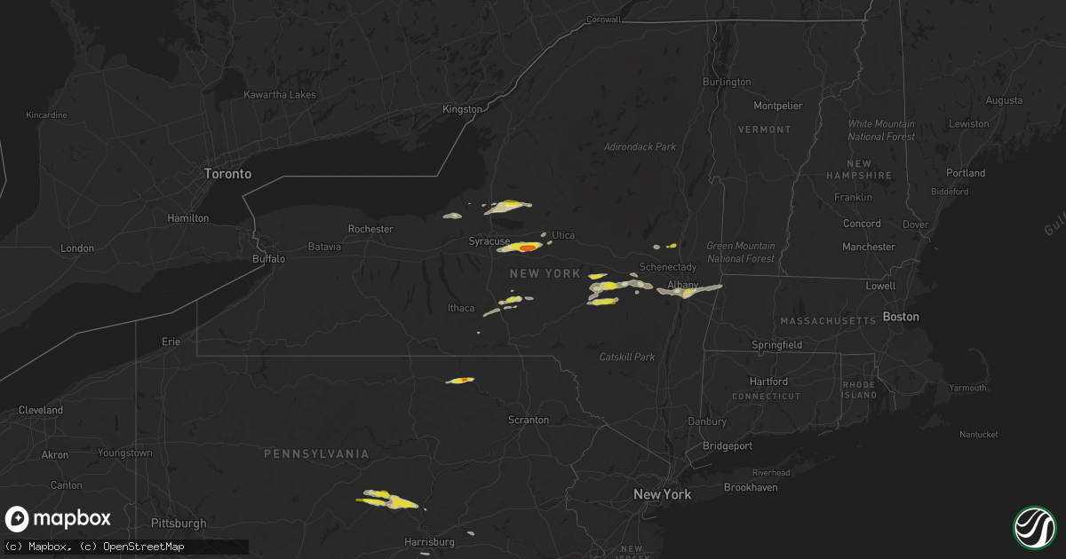
Hail Map in New York on August 12, 2017
Get this storm
August 12 map
$229
one time, instant access
Download today. No call, no setup
Keep the $229
Bought the map and want the full workflow? Apply the entire $229 to a subscription within 7 days. None of it is wasted.
Every map, not just this one
This buys you this map. Subscription and you get every map we run, in the markets you choose from a few cities to whole states to nationwide. Plus real-time alerts the moment a storm fires.
Contact data
Name, contact info, occupancy, even credit band for addresses in the footprint. You go from where it hit to who to call.
Become the source they trust
Unlimited branding weather history reports on demand. You already have the documented answer ready for the property owner, and you are the one who showed up with it.
Property data and RoofTrace estimates
Pull up any address you have got, its value and the exact code rules for that jurisdiction, straight from One Click Code. Then RoofTrace estimates the squares, pitch, and roof value, priced the way you price.
Storm reports in New York
New York
| Date | Description |
|---|---|
| 08/12/20176:05 PM CDT | 3 trees down and wires down. |
| 08/12/20176:01 PM CDT | A local report indicates 1.00 inch wind near EAST GREENBUSH |
| 08/12/20175:45 PM CDT | Trees down |
| 08/12/20175:25 PM CDT | Tree downed |
| 08/12/20174:42 PM CDT | House caught fire due to downed power lines. |
| 08/12/20174:41 PM CDT | A local report indicates 1.00 inch wind near 1 W RICHMONDVILLE |
| 08/12/20174:40 PM CDT | Multiple trees and wires down. |
| 08/12/20174:30 PM CDT | Trees and lines down. Radar based time. |
| 08/12/20174:30 PM CDT | Numerous trees and lines down. Took brunt of storm. Radar based time. |
| 08/12/20174:25 PM CDT | Trees and lines down. Radar based time. |
| 08/12/20174:12 PM CDT | Trees and lines down. Radar based time. |
| 08/12/20174:06 PM CDT | Numerous trees and lines down. Took brunt of storm. Radar based time. |
| 08/12/20173:49 PM CDT | Two trees down at the intersection of route 50 and hutchins road. |
| 08/12/20173:48 PM CDT | Tree down. |
| 08/12/20173:43 PM CDT | A local report indicates 1.00 inch wind near FACTORY VILLAGE |
| 08/12/20173:42 PM CDT | Trees and lines down |
| 08/12/20173:26 PM CDT | A local report indicates 1.50 inch wind near MUNNSVILLE |
| 08/12/20173:25 PM CDT | Tree down on junction road/blocking road |
| 08/12/20173:20 PM CDT | A local report indicates 1.25 inch wind near PETERBORO |
| 08/12/20173:15 PM CDT | Several trees down in area. Photos sent by emergency mgmt. Radar based time. |
| 08/12/20173:05 PM CDT | Multiple trees down |
| 08/12/20173:05 PM CDT | Tree down on state route 7 blocking the road |
| 08/12/20173:00 PM CDT | Multiple trees down blocking road including at state park. Via dispatch feed. |
| 08/12/20173:00 PM CDT | Tree down on mudlake road |
| 08/12/20172:49 PM CDT | Dime to quarter size hail |
| 08/12/20172:18 PM CDT | Trees and lines down. Radar based time. |
| 08/12/20172:10 PM CDT | Multiple trees uprooted. Lines down. Camps and boats damaged at sto-ne-nols campground. Radar based time. Media story online. |
| 08/12/20172:05 PM CDT | Nickel to quarter size hail 3 to 4 inches deep covering the ground |
| 08/12/20171:56 PM CDT | Trees and wires down - time estimated by radar |
| 08/12/20171:36 PM CDT | Trees and wires down - time estimated by radar |
| 08/12/20171:13 PM CDT | Trees down |
| 08/12/20171:13 PM CDT | Trees and wires down |
| 08/12/20171:00 PM CDT | Two reports of trees and wires down |
All States Impacted by Hail Map on August 12, 2017
Cities Impacted by Hail Map on August 12, 2017
- Dallas, SD
- Genoa, CO
- Camden, NY
- Central Square, NY
- Williamstown, NY
- Taberg, NY
- Westdale, NY
- Bernhards Bay, NY
- West Monroe, NY
- Parish, NY
- Constantia, NY
- Mallory, NY
- Julian, CA
- Hedgesville, WV
- New England, ND
- South Heart, ND
- Hettinger, ND
- Eagle Butte, SD
- Nunn, CO
- New Salem, ND
- Colome, SD
- Winner, SD
- Henrietta, TX
- Wood, SD
- Draper, SD
- Towanda, PA
- Boonsboro, MD
- Keedysville, MD
- Brewster, NE
- Little Orleans, MD
- Berkeley Springs, WV
- Hancock, MD
- Great Cacapon, WV
- Caliente, NV
- Limon, CO
- Agate, CO
- Dickinson, ND
- Akron, CO
- Otis, CO
- Reva, SD
- Ludlow, SD
- Buffalo, SD
- Midland, SD
- Ashley, ND
- Hemingford, NE
- Bridgeport, NE
- Alliance, NE
- Angora, NE
- Sterling City, TX
- Sadler, TX
- Whitesboro, TX
- Gainesville, TX
- Schoharie, NY
- Seligman, AZ
- Dolan Springs, AZ
- Rush, CO
- Cooperstown, NY
- Cherry Valley, NY
- Roseboom, NY
- Monrovia, MD
- Damascus, MD
- Mount Airy, MD
- Ijamsville, MD
- Mud Butte, SD
- Bison, SD
- Prairie City, SD
- Pritchett, CO
- Stratton, NE
- Palisade, NE
- Wauneta, NE
- Killdeer, ND
- Blue Ridge, TX
- Roscoe, TX
- East Worcester, NY
- Worcester, NY
- Richmondville, NY
- Colorado City, TX
- Tatum, TX
- Ovid, CO
- Cincinnatus, NY
- Marathon, NY
- Reedsville, PA
- Emory, TX
- Belvidere, SD
- Mansfield, LA
- Elkridge, MD
- Halethorpe, MD
- Baltimore, MD
- Ellicott City, MD
- Hanover, MD
- Linthicum Heights, MD
- Catonsville, MD
- Platte, SD
- Chamberlain, SD
- Kimball, SD
- Pukwana, SD
- Las Vegas, NM
- Pennellville, NY
- Haxtun, CO
- Lemmon, SD
- Show Low, AZ
- Broken Bow, NE
- Anselmo, NE
- Benkelman, NE
- North Platte, NE
- Venango, NE
- Berne, NY
- Grant, NE
- Whitehorse, SD
- Ridgeview, SD
- Timber Lake, SD
- Witten, SD
- Valentine, NE
- Point, TX
- Cumby, TX
- Brashear, TX
- Carson, ND
- Shields, ND
- Raleigh, ND
- Flasher, ND
- Yeagertown, PA
- Lewistown, PA
- Belleville, PA
- Burnham, PA
- Mifflintown, PA
- Ideal, SD
- Milroy, PA
- Amsterdam, NY
- Hagaman, NY
- Zap, ND
- Beulah, ND
- Brandywine, MD
- Upper Marlboro, MD
- Forbes, ND
- Leola, SD
- Davenport, NY
- Jefferson, NY
- East Meredith, NY
- Charlotteville, NY
- Schenevus, NY
- Atwood, KS
- Breaux Bridge, LA
- Kennebec, SD
- Howe, TX
- Van Alstyne, TX
- Shepherdstown, WV
- New Market, MD
- Brookeville, MD
- Rohrersville, MD
- Woodbine, MD
- Frederick, MD
- Sharpsburg, MD
- Myersville, MD
- Martinsburg, WV
- Middletown, MD
- Braddock Heights, MD
- Clarksburg, MD
- Fredonia, ND
- Pollock, SD
- Herreid, SD
- Selfridge, ND
- McLaughlin, SD
- Dunning, NE
- Pleasanton, NE
- Arnold, NE
- Amherst, NE
- Miller, NE
- Ansley, NE
- Oconto, NE
- Merna, NE
- Sumner, NE
- Mason City, NE
- Fort Pierre, SD
- Oneida, NY
- Oriskany Falls, NY
- Jamesville, NY
- Cazenovia, NY
- Morrisville, NY
- Munnsville, NY
- Vernon Center, NY
- Chittenango, NY
- Manlius, NY
- Canastota, NY
- Dalton, NE
- Broadwater, NE
- Lodgepole, NE
- West River, MD
- Churchton, MD
- Deale, MD
- Payson, AZ
- Kanab, UT
- Belfield, ND
- Sweetwater, TX
- Roby, TX
- Lafayette, LA
- Odessa, NE
- Axtell, NE
- Minden, NE
- Elm Creek, NE
- Kearney, NE
- Bassett, NE
- Newport, NE
- Loraine, TX
- Ainsworth, NE
- Purdum, NE
- Bayard, NE
- Lehr, ND
- Hague, ND
- Ortley, SD
- Summit, SD
- Kit Carson, CO
- Graham, TX
- Loving, TX
- Champion, NE
- McDonough, NY
- Bushnell, NE
- Waubay, SD
- Selby, SD
- Java, SD
- Anton, CO
- Cope, CO
- Mott, ND
- Wills Point, TX
- Thompsontown, PA
- McAlisterville, PA
- Oakland Mills, PA
- Richfield, PA
- Reliance, SD
- Cocolamus, PA
- McClure, PA
- Liverpool, PA
- Mount Pleasant Mills, PA
- Millerstown, PA
- Round Hill, VA
- Purcellville, VA
- Petersburg, NY
- Stephentown, NY
- Berlin, NY
- Trail City, SD
- Wysox, PA
- Gurley, NE
- Hannibal, NY
- Sterling, NY
- Cato, NY
- Red Creek, NY
- Martville, NY
- Wood Lake, NE
- De Berry, TX
- Medora, ND
- Marsland, NE
- Wishek, ND
- Saline, LA
- Vernon, NY
- Westmoreland, NY
- Rome, NY
- Haslet, TX
- Fort Worth, TX
- Cody, NE
- Thedford, NE
- Feura Bush, NY
- Selkirk, NY
- Glenmont, NY
- Delmar, NY
- Ore City, TX
- Johnstown, NE
- Chandler, AZ
- Summit, NY
- Maryland, NY
- Bedford, TX
- Athens, TX
- Grover, CO
- Zeeland, ND
- Millersburg, PA
- Grace, ID
- Amidon, ND
- Regent, ND
- Warnerville, NY
- Cobleskill, NY
- Calhan, CO
- White River, SD
- Presho, SD
- Willcox, AZ
- Norwich, NY
- Oxford, NY
- Julesburg, CO
- Troy, PA
- Weatherford, TX
- Halsey, NE
- Coushatta, LA
- Gregory, SD
- Herrick, SD
- Mills, NE
- Kingman, AZ
- Byers, CO
- Deming, NM
- Caddo Mills, TX
- Greenville, TX
- Whiterocks, UT
- Scott, LA
- Model, CO
- Canton, TX
- Middleburgh, NY
- Cottonwood, AZ
- Ballston Spa, NY
- Elsmere, NE
- Ogallala, NE
- Walker, SD
- Almont, ND
- Golden Valley, ND
- Clarkdale, AZ
- Chino Valley, AZ
- Maryneal, TX
- Taylor, NE
- Averill Park, NY
- Castleton On Hudson, NY
- Rensselaer, NY
- East Greenbush, NY
- West Sand Lake, NY
- Nassau, NY
- East Schodack, NY
- Manning, ND
- Fulton, NY
- Washington, DC
- Waynesboro, PA
- Hallsville, TX
- Marshall, TX
- Crawford, NE
- Springview, NE
- Brownsboro, TX
- Murchison, TX
- Odessa, TX
- Mayer, AZ
- Trenton, TX
- Leonard, TX
- Anna, TX
- Whitewright, TX
- Imperial, NE
- Madrid, NE
- Azle, TX
- Holabird, SD
- Kirk, CO
- Idalia, CO
- Franktown, CO
- Flagler, CO
- Gettysburg, SD
- Lower Brule, SD
- Harrisburg, NE
- Lindon, CO
- Williamstown, MA
- Sand Lake, NY
- Fleming, CO
- Smithville Flats, NY
- Willet, NY
- Oxford, NC
- Rougemont, NC
- Flintstone, MD
- Lewisville, TX
- Flower Mound, TX
- Arriba, CO
- Leupp, AZ
- Lovettsville, VA
- Ben Wheeler, TX
- Pilgrim, KY
- Debord, KY
- Westerville, NE
- Crane, TX
- McCamey, TX
- Midland, TX
- De Ruyter, NY
- Pitcher, NY
- Hurricane, UT
- Anton Chico, NM
- Santa Rosa, NM
- Agar, SD
- Diana, TX
- Bennett, CO
- Shreveport, LA
- Chappell, NE
- Camp Verde, AZ
- Pierre, SD
- Animas, NM
- Howes Cave, NY
- East Berne, NY
- Altamont, NY
- Alba, TX
- Washington, UT
- Saint George, UT
- Peyton, CO
- Riverton, WY
- Riverdale, NE
- Harleton, TX
- Conde, SD
- Bellevue, TX
- Farmersville, TX
- Winston, NM
- Caballo, NM
- Enders, NE
- Stanton, ND
- Highmore, SD
- Flagstaff, AZ
- Collinsville, TX
- Sedgwick, CO
- Harpers Ferry, WV
- Charles Town, WV
- Bluemont, VA
- Denver, CO
- Voorheesville, NY
- Albany, NY
- Clarksville, NY
- Elm City, NC
- Wilson, NC
- Elsie, NE
- Millersville, MD
- Glen Burnie, MD
- Mercersburg, PA
- Murdo, SD
- Mission, SD
- Hazard, NE
- Montpelier, VT
- Napoleon, ND
- Hastings, NY
- Strasburg, CO
- Mechanicsburg, PA
- Dillsburg, PA
- Grantham, PA
- Lewisberry, PA
- Burlington, CO
- Vivian, SD
- Golden, CO
- Esperance, NY
- Sloansville, NY
- Central Bridge, NY
- Galway, NY
- Terrell, TX
- Lone Oak, TX
- Gunter, TX
- Lebanon, PA
- Logansport, LA
- Richford, NY
- Candor, NY
- Greencastle, PA
- Clinton, NY
- Deansboro, NY
- De Queen, AR
- Yoder, CO
- Huntingdon, PA
- Litchfield, NE
- Kimball, NE
- Long Pine, NE
- Trenton, NE
- Sargent, NE
- Wibaux, MT


