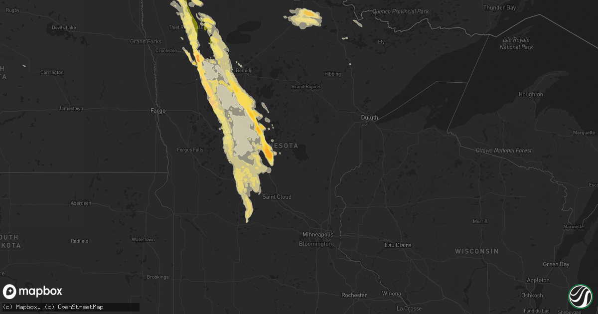
Hail Map in Minnesota on August 12, 2015
Get this storm
August 12 map
$229
one time, instant access
Download today. No call, no setup
Keep the $229
Bought the map and want the full workflow? Apply the entire $229 to a subscription within 7 days. None of it is wasted.
Every map, not just this one
This buys you this map. Subscription and you get every map we run, in the markets you choose from a few cities to whole states to nationwide. Plus real-time alerts the moment a storm fires.
Contact data
Name, contact info, occupancy, even credit band for addresses in the footprint. You go from where it hit to who to call.
Become the source they trust
Unlimited branding weather history reports on demand. You already have the documented answer ready for the property owner, and you are the one who showed up with it.
Property data and RoofTrace estimates
Pull up any address you have got, its value and the exact code rules for that jurisdiction, straight from One Click Code. Then RoofTrace estimates the squares, pitch, and roof value, priced the way you price.
Storm reports in Minnesota
Minnesota
| Date | Description |
|---|---|
| 08/12/20156:54 PM CDT | A local report indicates 1.00 inch wind near 1 N NEVIS |
| 08/12/20156:50 PM CDT | A local report indicates 1.25 inch wind near NEVIS |
| 08/12/20156:40 PM CDT | Spotter noticed an occasional poplar tree blown over ...along with dents in vehicles caused by hail...along a route from emmavile into nevis. |
| 08/12/20156:36 PM CDT | A local report indicates 1.00 inch wind near 2 E EMMAVILLE |
| 08/12/20156:20 PM CDT | A sixteen inch diameter pine tree was snapped... And some half inch diameter fell. |
| 08/12/20155:55 PM CDT | A local report indicates 1.00 inch wind near 4 SE ROSEAU |
| 08/12/20155:52 PM CDT | Tree downed by strong winds |
| 08/12/20155:50 PM CDT | Numerous pine trees broken down around the area. Time estimated based on radar. |
| 08/12/20155:45 PM CDT | A mix of quarter to golf ball sized hail... |
| 08/12/20155:32 PM CDT | A local report indicates 1.00 inch wind near 1 N CLEARBROOK |
| 08/12/20155:30 PM CDT | Ruler measured 3.5 inch hail |
| 08/12/20155:28 PM CDT | Numerous very large hailstones were collected and photographed...measuring from 4 to 4.5 inches in diameter. Reports and photos were posted via social media. |
| 08/12/20155:26 PM CDT | A local report indicates 2.75 inch wind near FOX |
| 08/12/20155:24 PM CDT | A local report indicates 1.75 inch wind near FOX |
| 08/12/20155:20 PM CDT | Several grain bins sustained significant damage. Wind speeds estimated in excess of 80 mph. |
| 08/12/20155:15 PM CDT | Numerous large tree branches andflimbs were broken down across far northeast polk county...resulting in widespread power outages. |
| 08/12/20155:15 PM CDT | A local report indicates 2.75 inch wind near 6 N BADGER |
| 08/12/20155:10 PM CDT | Numerous large tree branches and limbs broken down across portions of roland township resulting in widespread power outages. |
| 08/12/20155:07 PM CDT | Several grain bins sustained significant damage. Large round hay balls blown across a field. Several large tree branches and limbs broken down in shelter belts across d |
| 08/12/20155:05 PM CDT | Several grain bins sustained significant damage. Large round hay balls blown across a field. Wind speeds estimated in excess of 80 mph. |
| 08/12/20155:05 PM CDT | Numerous large tree branches and limbs were broken down around star and hickory townships...and at least two wooden power poles were snapped...resulting in widspread po |
| 08/12/20155:00 PM CDT | A local report indicates 1.75 inch wind near 5 WSW PINECREEK |
| 08/12/20155:00 PM CDT | Resident reported a roof anchored antenna was ripped off and a well anchored down 8 foot wind mill was blown over...as well as power outage from 430 pm to 830 pm |
| 08/12/20153:49 PM CDT | Time estimated by radar |
| 08/12/20153:54 AM CDT | Medium size tree toppled over road near intersection of palm nad 322 st. In ne portion of bradford township. Time estimated from radar. |
| 08/12/20153:53 AM CDT | Medium size tree toppled near intersection of 317th st and aleck road in ne portion of bradford township. Time estimated from radar. |
| 08/12/20153:50 AM CDT | Large tree blocking one half of spirit river drive in sw portion of city. Time estimated from radar. |
| 08/12/20153:48 AM CDT | Tree toppled near intersection of highway 95 and blackfoot st. Time estimated from radar. |
| 08/12/20153:45 AM CDT | Trees snapped or uprooted...medium tree toppled and several small-medium sized branches torn off along marigold drive. |
| 08/12/20151:14 AM CDT | A few trees toppled. One tree severed power line. Time estimated from radar. |
| 08/12/20151:00 AM CDT | A local report indicates 1.00 inch wind near 3 SW WADENA |
| 08/12/201512:20 AM CDT | Large hail. Hard to see because power is out. |
| 08/12/201512:01 AM CDT | Several minutes of hail occurred... With a few minutes of hail that was larger than a quarter. |
| 08/11/201511:40 PM CDT | A local report indicates 2.00 inch wind near 3 S NAYTAHWAUSH |
| 08/11/201511:33 PM CDT | Hail from quarter to golf ball sized fell for a few minutes. |
| 08/11/201511:32 PM CDT | Hail from quarter to golf ball sized fell for a few minutes. |
| 08/11/201511:10 PM CDT | Large hail continued for nearly 10 minutes. |
| 08/11/201511:00 PM CDT | Report and photo posted via social media. Time estimated based on radar. |
| 08/11/201510:55 PM CDT | Hail from dime to quarter sized covered the ground. |
| 08/11/201510:55 PM CDT | Hail from dime to quarter sized covered the ground. |
| 08/11/201510:39 PM CDT | Report and photo posted via social media. |
| 08/11/201510:30 PM CDT | Report posted to social media. Time estimated based on radar. |
| 08/11/201510:08 PM CDT | Report and photo posted via social media. |
| 08/11/201510:00 PM CDT | Report and photo posted via social media. |
| 08/11/20159:45 PM CDT | Occassional large tree branches and limbs were broken down in shelter belts and groves across western smiley and wynadote townships. |
| 08/11/20159:35 PM CDT | Numerous large tree branches and limbs were blown down. Meatal and plastic business signage was blown out. Peak winds estimated to 80 mph. |
| 08/11/20159:33 PM CDT | A few trees uprooted and numerous large branches and limbs were broken down around town. One small radio tower bent over at the middle. One wooden billboard was blown d |
| 08/11/20159:30 PM CDT | Report and picture posted via social media. |
| 08/11/20159:26 PM CDT | A local report indicates 1.00 inch wind near 6 N CAMP RIPLEY JUNCTION |
| 08/11/20159:20 PM CDT | Trees reported broken down near the pennington county line. Time estimated based on radar. |
| 08/11/20159:17 PM CDT | Largest hail was baseball size. Still some golf ball size hail after one hour. |
| 08/11/20159:10 PM CDT | Large hail and very strong winds... But no wind damage is readily apparent in the yard. |
| 08/11/20159:08 PM CDT | A local report indicates 2.00 inch wind near 2 SSW CROW WING STATE P |
| 08/11/20159:06 PM CDT | A local report indicates 1.00 inch wind near NNW CROW WING STATE PAR |
| 08/11/20159:04 PM CDT | Piles of large hail still in the ditches the following morning. |
| 08/11/20159:00 PM CDT | Large branches reported broken down around town. Report posted via social media. |
| 08/11/20158:32 PM CDT | A local report indicates 1.00 inch wind near 5 W LAKE SHORE |
| 08/11/20158:32 PM CDT | Measured on cartop anemometer. |
| 08/11/20158:28 PM CDT | Report and picture posted via social media. |
| 08/11/20158:10 PM CDT | Reports and pictures posted via social media. Time estimated based on radar. |
| 08/11/20158:08 PM CDT | A local report indicates 1.00 inch wind near 7 ENE LEADER |
| 08/11/20158:08 PM CDT | Several 5 inch diameter pine trees down. One 10 inch diameter oak tree split. |
| 08/11/20158:00 PM CDT | A local report indicates 1.00 inch wind near 2 SW GREENBUSH |
| 08/11/20157:50 PM CDT | Numerous trees down. One tree 10 inches in diameter blocking co rd 25. |
| 08/11/20157:50 PM CDT | Spotter found hail approx 1 hour after storm passed. |
| 08/11/20157:20 PM CDT | A local report indicates 1.75 inch wind near 3 W OSHAWA |
| 08/11/20157:01 PM CDT | Numerous trees snapped around town... Pine... Maple and poplar. |
All States Impacted by Hail Map on August 12, 2015
Cities Impacted by Hail Map on August 12, 2015
- Goodridge, MN
- Grygla, MN
- Long Prairie, MN
- Erskine, MN
- Mentor, MN
- Strathcona, MN
- Middle River, MN
- Gatzke, MN
- Atwater, MN
- Gonvick, MN
- Leonard, MN
- Clearbrook, MN
- Bagley, MN
- Naytahwaush, MN
- Mahnomen, MN
- Fosston, MN
- Roseau, MN
- Littlefork, MN
- Nisswa, MN
- Solway, MN
- Gully, MN
- Cushing, MN
- Laporte, MN
- Park Rapids, MN
- Pillager, MN
- Pequot Lakes, MN
- Lake George, MN
- Bemidji, MN
- Staples, MN
- Nevis, MN
- Little Falls, MN
- Menahga, MN
- Shevlin, MN
- Motley, MN
- Brainerd, MN
- Baxter, MN
- Pine River, MN
- Akeley, MN
- Backus, MN
- Fort Ripley, MN
- Thief River Falls, MN
- Greenbush, MN
- Karlstad, MN
- Strandquist, MN
- Newfolden, MN
- Sebeka, MN
- New York Mills, MN
- New London, MN
- Ponsford, MN
- Winger, MN
- Brooks, MN
- Burtrum, MN
- Detroit Lakes, MN
- Oklee, MN
- Lake Bronson, MN
- Melrose, MN
- Perham, MN
- Freeport, MN
- Randall, MN
- Flensburg, MN
- Mcintosh, MN
- Wadena, MN
- Clarissa, MN
- Saint Hilaire, MN
- Red Lake Falls, MN
- Plummer, MN
- Eagle Bend, MN
- Sauk Centre, MN
- Callaway, MN
- Henning, MN
- Belgrade, MN
- Holdingford, MN
- Bowlus, MN
- Frazee, MN
- Avon, MN
- Carlos, MN
- Bluffton, MN
- Spicer, MN
- Grey Eagle, MN
- Osakis, MN
- Osage, MN
- Halma, MN
- Bejou, MN
- Parkers Prairie, MN
- Waubun, MN
- Rochert, MN
- Lancaster, MN
- Paynesville, MN
- Miltona, MN
- Hewitt, MN
- Grove City, MN
- Swanville, MN
- Browerville, MN
- Upsala, MN
- Verndale, MN
- Albany, MN
- Hackensack, MN
- Lengby, MN
- Deer Creek, MN
- Bertha, MN
- Ogema, MN
- Livingston, TX
- Onalaska, TX
- Iowa, LA
- Lake Charles, LA
- Midway, GA
- Badger, MN
- Boulder, MT
- Whitehall, MT
- Cook, MN
- International Falls, MN
- Salol, MN
- Hoodsport, WA
- Shelton, WA
- Duvall, WA
- Big Falls, MN
- Dayton, WA
- Lafitte, LA
- Barataria, LA
- Fort Pierce, FL
- Orr, MN
- Glen Ullin, ND
- Elgin, ND
- New Leipzig, ND
- Drake, ND
- Warroad, MN
- North Bend, WA
- Ranier, MN
- Seattle, WA
- Virginia, MN
- Woodinville, WA
- Redmond, WA
- Coldspring, TX
- Willis, TX
- New Waverly, TX
- Cleveland, TX
- Bowdon, ND
- Bellevue, WA
- Vero Beach, FL
- Brooten, MN
- Elrosa, MN
- Wannaska, MN
- Richmond Hill, GA
- Aldrich, MN
- Hallock, MN
- Uvalde, TX


