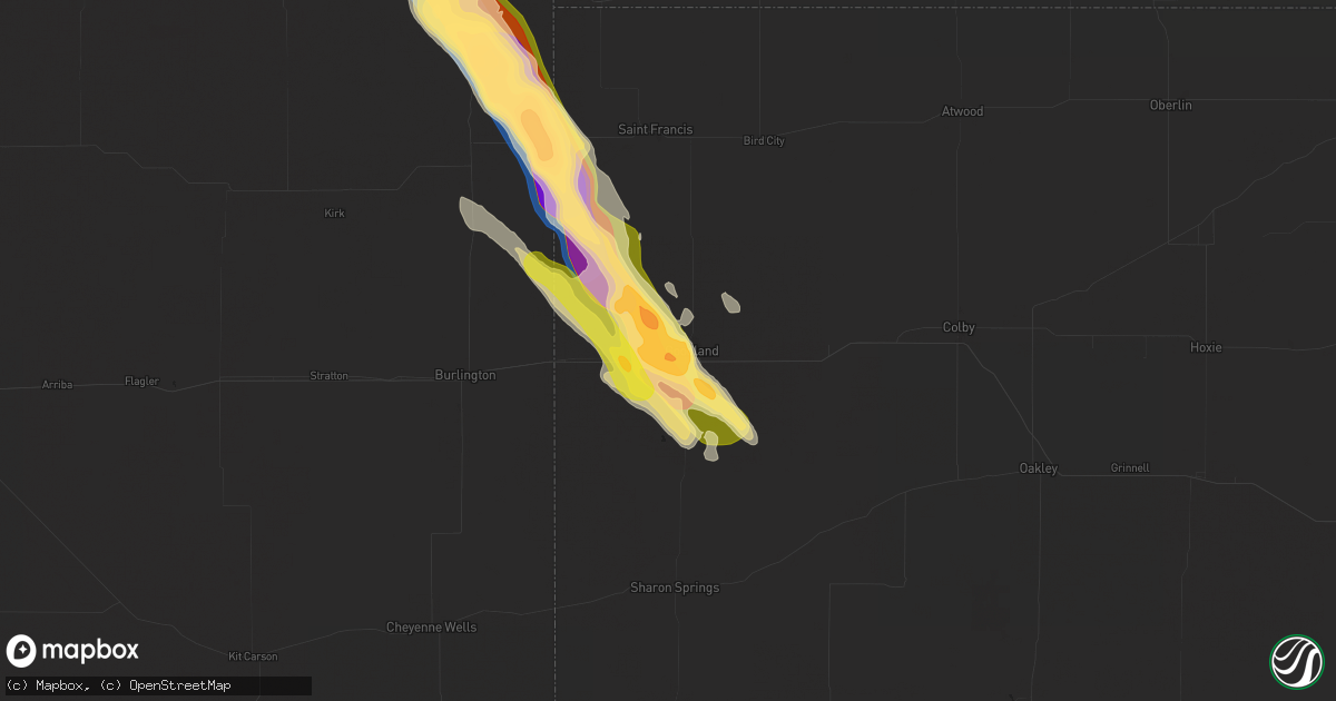
Hail Map in Goodland, KS on August 11, 2024
Get this storm
August 11 map
$229
one time, instant access
Download today. No call, no setup
Keep the $229
Bought the map and want the full workflow? Apply the entire $229 to a subscription within 7 days. None of it is wasted.
Every map, not just this one
This buys you this map. Subscription and you get every map we run, in the markets you choose from a few cities to whole states to nationwide. Plus real-time alerts the moment a storm fires.
Contact data
Name, contact info, occupancy, even credit band for addresses in the footprint. You go from where it hit to who to call.
Become the source they trust
Unlimited branding weather history reports on demand. You already have the documented answer ready for the property owner, and you are the one who showed up with it.
Property data and RoofTrace estimates
Pull up any address you have got, its value and the exact code rules for that jurisdiction, straight from One Click Code. Then RoofTrace estimates the squares, pitch, and roof value, priced the way you price.
Storm reports in Goodland, KS
Goodland, KS
| Date | Description |
|---|---|
| 08/11/20246:47 PM CDT | Phone report of hail ranging from pea to quarter size in hail. No longer hailing as of call. |
| 08/10/20247:32 PM CDT | Phone call report of wind driven hail with winds estimated around 65 to 70 mph. Wind driven hail broke windows. |
| 08/10/20247:32 PM CDT | Phone call report of wind driven hail with winds estimated around 65 to 70 mph. Wind drive |
| 08/10/20247:32 PM CDT | Delayed report of a tree uprooted and multiple other branches torn off tree. |
| 08/10/20247:23 PM CDT | Phone call reporting hail between pea and golf ball with a few 2 inch stones. Multiple broken windows due to wind driven hail. |
| 08/10/20247:22 PM CDT | Relayed report with picture of a tree with a long branch split and hanging from the main tree. Estimated diameter is 3 to 6 inches from picture. |
| 08/10/20247:22 PM CDT | Delayed report of medium sized tree damage in southwestern goodland. |
| 08/10/20247:22 PM CDT | Relayed report of hail around half dollar in size. |
| 08/10/20247:19 PM CDT | Multiple reports from employees... Spotters... And the public of hail between half an inch to an inch in size. Multiple reports of hail covering the ground. |
| 08/10/20247:19 PM CDT | Report from mping: ping pong ball |
| 08/10/20247:15 PM CDT | Report from mping: quarter |
| 08/10/20247:14 PM CDT | Delayed report of an irrigation pivot overturned south of i-70 between cr 20 and ks 27. |
All States Impacted by Hail Map on August 11, 2024
All Cities Impacted by Hail Map on August 11, 2024
- Vici, OK
- Atwood, KS
- Rexford, KS
- Colby, KS
- Lead, SD
- Barker, NY
- Gasport, NY
- Appleton, NY
- Sidney, MT
- Lyndonville, NY
- Middleport, NY
- Medina, NY
- Albion, NY
- Newfane, NY
- Waterport, NY
- Kent, NY
- Holley, NY
- Kendall, NY
- Brockport, NY
- Hamlin, NY
- Norway, SC
- Blackville, SC
- Neeses, SC
- Rapid City, SD
- Warner Springs, CA
- Webster, NY
- Ontario, NY
- Colorado City, AZ
- Sodus, NY
- Williamson, NY
- Hermosa, SD
- Keystone, SD
- Mims, FL
- Ferron, UT
- Fulton, NY
- Phoenix, NY
- Hardeeville, SC
- Quincy, FL
- Caputa, SD
- Fairburn, SD
- Pine Ridge, SD
- West Monroe, NY
- Central Square, NY
- Sterling, CO
- Scenic, SD
- New Underwood, SD
- Winslow, AZ
- Constantia, NY
- Bernhards Bay, NY
- Cleveland, NY
- Camden, NY
- Crawford, NE
- Garnett, SC
- Merino, CO
- Fleming, CO
- Hemingford, NE
- Marsland, NE
- Littlefield, AZ
- Pineland, SC
- Kyle, SD
- Panguitch, UT
- Williams, AZ
- Yuma, CO
- Otis, CO
- Grand Canyon, AZ
- Porcupine, SD
- Alliance, NE
- Hay Springs, NE
- Haxtun, CO
- Allen, SD
- Dammeron Valley, UT
- Merriman, NE
- Martin, SD
- Batesland, SD
- Ellsworth, NE
- Eckley, CO
- Wray, CO
- Huntington, UT
- Manderson, SD
- Lakeside, NE
- Chino Valley, AZ
- Cody, NE
- Ashby, NE
- Bingham, NE
- Vernon, CO
- Ivins, UT
- Seligman, AZ
- Oshkosh, NE
- Idalia, CO
- Saint Francis, KS
- Hinckley, UT
- Valentine, NE
- Ash Fork, AZ
- Waynesville, GA
- Kanorado, KS
- Goodland, KS
- Whitman, NE
- Middlesex, NC
- Kenly, NC
- Selma, NC
- Zebulon, NC
- Burlington, CO
- Arthur, NE
- Sims, NC
- Bailey, NC
- Thedford, NE
- Edson, KS
- Peach Springs, AZ
- Fillmore, UT
- Herndon, KS
- Helper, UT
- Pioche, NV
- Lamont, OK
- Medford, OK
- Hunter, OK
- Pawhuska, OK
- Wynona, OK
- Tonkawa, OK
- Red Rock, OK
- Barnsdall, OK
- Blackwell, OK
- Nardin, OK
- Deer Creek, OK
- Cleveland, OK
- Jennings, OK
- Pawnee, OK
- Maramec, OK
- Mannford, OK
- Terlton, OK
- Ponca City, OK
- Ralston, OK
- Braman, OK
- Morrison, OK
- Drumright, OK
- Glencoe, OK
- Yale, OK
- Lamar, CO
- Marland, OK
- Holly, CO
- Granada, CO
- Fairfax, OK
- Oxford, KS
- Depew, OK
- Bristow, OK
- Kellyville, OK
- Winfield, KS
- Sapulpa, OK
- Beggs, OK
- Hominy, OK
- Pinehurst, NC
- Aberdeen, NC
- Southern Pines, NC
- Raeford, NC
- Fort Bragg, NC
- Vass, NC
- Fayetteville, NC
- Hope Mills, NC
- West End, NC
- Jackson Springs, NC


