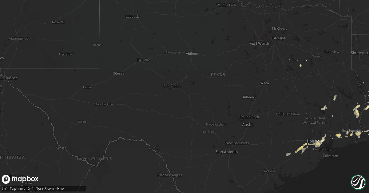
Hail Map in Texas on August 11, 2015
Get this storm
August 11 map
$229
one time, instant access
Download today. No call, no setup
Keep the $229
Bought the map and want the full workflow? Apply the entire $229 to a subscription within 7 days. None of it is wasted.
Every map, not just this one
This buys you this map. Subscription and you get every map we run, in the markets you choose from a few cities to whole states to nationwide. Plus real-time alerts the moment a storm fires.
Contact data
Name, contact info, occupancy, even credit band for addresses in the footprint. You go from where it hit to who to call.
Become the source they trust
Unlimited branding weather history reports on demand. You already have the documented answer ready for the property owner, and you are the one who showed up with it.
Property data and RoofTrace estimates
Pull up any address you have got, its value and the exact code rules for that jurisdiction, straight from One Click Code. Then RoofTrace estimates the squares, pitch, and roof value, priced the way you price.
Storm reports in Texas
Texas
| Date | Description |
|---|---|
| 08/11/20156:45 PM CDT | Quarter size hail in richmond. |
| 08/11/20156:42 PM CDT | Large tree was downed in a backyard near the intersection of monroe road and interstate 45. |
| 08/11/20156:42 PM CDT | Large tree was downed in a backyard near the intersection of monroe road and interstate 45. |
| 08/11/20156:31 PM CDT | Wind gust was measured at sugar land asos site ksgr. |
| 08/11/20156:24 PM CDT | A local report indicates 1.00 inch wind near 2 NW SUGAR LAND |
| 08/11/20156:19 PM CDT | Asos report from houston hobby airport. |
| 08/11/20156:00 PM CDT | 3 trees down near highway 21 and brazos river. Kbtx media retweet. |
| 08/11/20156:00 PM CDT | Freeway sign wind damage at scott street and loop 610 |
| 08/11/20154:54 PM CDT | Thunderstorm wind gust was measured at dwh asos site. |
| 08/11/20154:24 PM CDT | Trees blown down... One on a truck |
| 08/11/20154:05 PM CDT | 5 general aviation aircraft were picked up and thrown approx 150 yards at hawthorne field in kountze... Tx. All five aircraft were described as totalled. |
| 08/11/20153:40 PM CDT | Multiple trees down 1 mile nw of flint |
| 08/11/20153:30 PM CDT | Numerous trees down and a roof peeled back off a home on fm road 756...just north of the antioch community. |
| 08/11/20153:28 PM CDT | Trees downed behind weingarten shopping center in south tyler. |
All States Impacted by Hail Map on August 11, 2015
Cities Impacted by Hail Map on August 11, 2015
- Aurora, CO
- Englewood, CO
- Denver, CO
- Tyrone, OK
- Florence, AZ
- Call, TX
- Bon Wier, TX
- Kirbyville, TX
- Newton, TX
- Deridder, LA
- Vail, AZ
- Iva, SC
- Orange, TX
- Cameron, LA
- Bridge City, TX
- Port Arthur, TX
- Sherrills Ford, NC
- Maiden, NC
- Denver, NC
- Beaumont, TX
- Devers, TX
- Tucson, AZ
- El Campo, TX
- Douglas, AZ
- Georgiana, AL
- Larue, TX
- Brownsboro, TX
- Murchison, TX
- Chandler, TX
- Gila Bend, AZ
- Highlands, TX
- Channelview, TX
- Houston, TX
- La Porte, TX
- Crosby, TX
- Deer Park, TX
- Baytown, TX
- Tombstone, AZ
- Livingston, TX
- Kaplan, LA
- Crowley, LA
- Morse, LA
- Chandler, AZ
- Oracle, AZ
- Casa Grande, AZ
- Sulphur, LA
- Lake Charles, LA
- Hackberry, LA
- Iowa, LA
- Bell City, LA
- Gueydan, LA
- Fulshear, TX
- Wallis, TX
- Littleton, CO
- Leupp, AZ
- Flagstaff, AZ
- Eloy, AZ
- Rosenberg, TX
- Richmond, TX
- Coolidge, AZ
- Hereford, AZ
- Galena Park, TX
- South Houston, TX
- Pasadena, TX
- Blue River, OR
- Sugar Land, TX
- Hooker, OK
- Bedford, VA
- Sedalia, CO
- Athens, TX
- Leesville, LA
- Fort Polk, LA
- Corrigan, TX
- Huntington, TX
- Lufkin, TX
- Perryton, TX
- Goldston, NC
- Kemp, TX
- Stanley, NC
- Iron Station, NC
- Martinsville, VA
- Ridgeway, VA
- Rapid City, SD
- Hill City, SD
- Abbeville, LA
- Beasley, TX
- Wharton, TX
- East Bernard, TX
- Needville, TX
- Chinle, AZ
- Nederland, TX
- Port Neches, TX
- Pinon, AZ
- Java, VA
- Keeling, VA
- Winnie, TX
- Heber, AZ
- Merryville, LA
- Queen Creek, AZ
- Gilbert, AZ
- Willcox, AZ
- Miami, TX
- Red Rock, AZ
- Show Low, AZ
- Many, LA
- Pearland, TX
- Eagle Lake, TX
- Yanceyville, NC
- New Iberia, LA
- Broussard, LA
- Benson, AZ
- Marion Station, MD
- Malakoff, TX
- Cheraw, SC
- Patrick, SC
- Richey, MT
- Reidsville, NC
- Pocomoke City, MD
- Anacoco, LA
- Vinton, LA
- Rayne, LA
- Siler City, NC
- Bear Creek, NC
- Fort Lauderdale, FL
- Lacassine, LA
- Westlake, LA
- Dry Fork, VA
- Safford, AZ
- Cotopaxi, CO
- Williamsburg, VA
- Mineral, VA
- Manning, SC
- Liberty, TX
- Girdletree, MD
- Wallisville, TX
- Huntsville, TX
- Florien, LA
- Webster, TX
- Dayton, TX
- Stafford, TX
- Missouri City, TX
- Chatham, VA
- Sedona, AZ
- East Bend, NC


