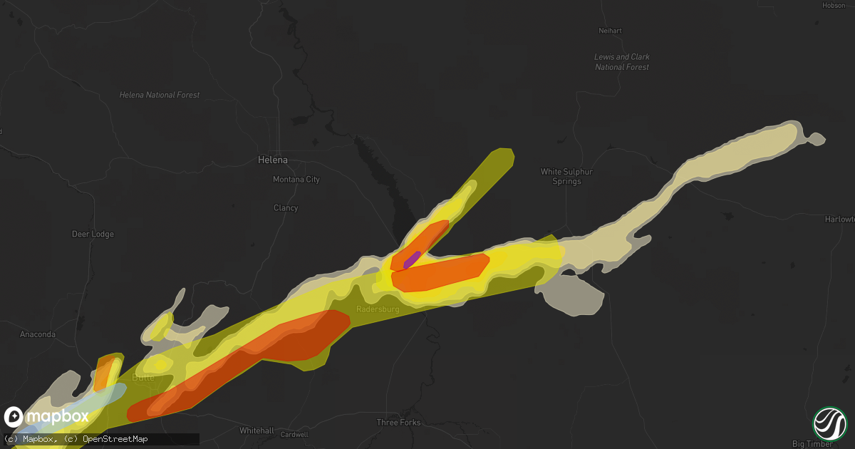
Hail Map in Townsend, MT on August 10, 2019
Get this storm
August 10 map
$229
one time, instant access
Download today. No call, no setup
Keep the $229
Bought the map and want the full workflow? Apply the entire $229 to a subscription within 7 days. None of it is wasted.
Every map, not just this one
This buys you this map. Subscription and you get every map we run, in the markets you choose from a few cities to whole states to nationwide. Plus real-time alerts the moment a storm fires.
Contact data
Name, contact info, occupancy, even credit band for addresses in the footprint. You go from where it hit to who to call.
Become the source they trust
Unlimited branding weather history reports on demand. You already have the documented answer ready for the property owner, and you are the one who showed up with it.
Property data and RoofTrace estimates
Pull up any address you have got, its value and the exact code rules for that jurisdiction, straight from One Click Code. Then RoofTrace estimates the squares, pitch, and roof value, priced the way you price.
Storm reports in Townsend, MT
Townsend, MT
| Date | Description |
|---|---|
| 08/09/20198:20 PM CDT | Some body damage to trucks. Spotter reports that a neighbor had windows broken by hail. |
| 08/09/20197:45 PM CDT | A local report indicates 1.75 inch wind near TOWNSEND |
| 08/09/20197:15 PM CDT | Hail estimated up to 2 inches in diameter in the townsend area. Reports of house windows broken... Car windshields cracked and vehicles dented. Time and hail size of ev |
| 08/09/20197:10 PM CDT | A local report indicates 1.75 inch wind near TOWNSEND |
| 08/09/20197:10 PM CDT | A local report indicates 1.75 inch wind near 1 NW TOWNSEND |
All States Impacted by Hail Map on August 10, 2019
All Cities Impacted by Hail Map on August 10, 2019
- Mountain Home Afb, ID
- Bruneau, ID
- Grand View, ID
- Waterville, WA
- Crawford, NE
- Harrison, NE
- Fremont, NE
- Belvidere, NE
- New Bern, NC
- Aurora, NC
- Bayboro, NC
- Drummond, MT
- Newcastle, WY
- Moorcroft, WY
- Clancy, MT
- Burgaw, NC
- Crosby, ND
- Columbus, ND
- Mcgregor, ND
- Wildrose, ND
- Noonan, ND
- Meadow, SD
- Bison, SD
- Toston, MT
- Winston, MT
- White Sulphur Springs, MT
- Two Dot, MT
- Martinsdale, MT
- Ringling, MT
- Townsend, MT
- Hoxie, KS
- Hill City, KS
- Palco, KS
- Red Lodge, MT
- Roberts, MT
- Venango, NE
- Grant, NE
- Moses Lake, WA
- Keystone, NE
- Arthur, NE
- Jacksonville, NC
- Oakfield, ME
- Boulder, MT
- Julesburg, CO
- Elsie, NE
- Madrid, NE
- Island Falls, ME
- Faith, SD
- Chattaroy, WA
- Deer Park, WA
- Decker, MT
- Holyoke, CO
- Mitchell, OR
- Saint Regis, MT
- Pullman, WA
- Minden, IA
- McClelland, IA
- Lusk, WY
- Lance Creek, WY
- Reeder, ND
- Scranton, ND
- Clearmont, WY
- Fairburn, SD
- Gillette, WY
- Scott City, KS
- Ludlow, SD
- Ralph, SD
- Grinnell, KS
- Supply, NC
- Delco, NC
- Alva, WY
- Crescent, IA
- Whitehall, MT
- Skowhegan, ME
- Divide, MT
- Folkston, GA
- Anaconda, MT
- Mescalero, NM
- Black Hawk, SD
- Piedmont, SD
- Garden City, KS
- Culbertson, NE
- Stratton, NE
- Trenton, NE
- Palisade, NE
- Wisdom, MT
- Hulett, WY
- Pilot Rock, OR
- Melville, MT
- Shawmut, MT
- Lead, SD
- Spearfish, SD
- Plainville, KS
- Green Cove Springs, FL
- Middleburg, FL
- Colby, KS
- Nemo, SD
- Rapid City, SD
- Clovis, NM
- Stanley, ND
- Ellsworth, NE
- Hayes Center, NE
- Wauneta, NE
- Sandpoint, ID
- Ellis, KS
- Morland, KS
- Wakeeney, KS
- Paradise, KS
- Waldo, KS
- Stockton, KS
- Natoma, KS
- Prairie City, OR
- McDonald, KS
- Bird City, KS
- Ransom, KS
- Mead, WA
- Corning, CA
- Orland, CA
- Clinton, MT
- Butte, MT
- Lucas, KS
- Buffalo, SD
- Benkelman, NE
- Max, NE
- McCook, NE
- Americus, KS
- Grantsboro, NC
- Lowland, NC
- Hobucken, NC
- Hartline, WA
- Sundance, WY
- Aladdin, WY
- Collyer, KS
- Chadron, NE
- Whitney, NE
- Yates Center, KS
- Rozet, WY
- Lodgepole, SD
- Winona, KS
- Emporia, KS
- Mud Butte, SD
- Luray, KS
- Ramsay, MT
- Hermosa, SD
- New Leipzig, ND
- Salina, KS
- Floyd, NM
- Portales, NM
- Shoup, ID
- Rocky Point, NC
- Lefor, ND
- Mott, ND
- Coyanosa, TX
- Wilson, KS
- Bunker Hill, KS
- Dorrance, KS
- Russell, KS
- Wallace, KS
- Eustis, NE
- Ogallala, NE
- Hay Springs, NE
- Minneapolis, KS
- Syracuse, KS
- Gove, KS
- Beulah, WY
- Brady, NE
- Sheridan Lake, CO
- Palermo, ND
- Keystone, SD
- Brookville, KS
- Edward, NC
- Rexford, KS
- Stockville, NE
- Waitsburg, WA
- Gypsum, KS
- Fontana, KS
- Paola, KS
- Coeur D Alene, ID
- Salmon, ID
- Harkers Island, NC
- Beaufort, NC
- Gloucester, NC
- Oakley, KS
- Deadwood, SD
- Quinter, KS
- Tensed, ID
- Saint Maries, ID
- Edson, KS
- Leland, NC
- Humboldt, KS
- Haxtun, CO
- Fleming, CO
- Goodland, KS
- Kanorado, KS
- Killdeer, ND
- Iola, KS
- Athol, ID
- Wilson Creek, WA
- Malaga, WA
- Pomeroy, WA
- Harrison, ID
- Cataldo, ID
- Thorp, WA
- Ellensburg, WA
- Alexander, ND
- Brewster, KS
- John Day, OR
- Mansfield, WA
- Powers Lake, ND
- Devils Tower, WY
- Osborne, KS
- Palatka, FL
- Custer, SD
- Mountain Home, ID
- Alton, KS
- Weston, WY
- Dayton, WA
- Jackson, MT
- Sunnyside, WA
- Moxee, WA
- Swanquarter, NC
- Carmen, ID
- Basin, MT
- Townsend, GA
- Young, AZ
- Condon, OR
- Hayden, ID
- Clay Center, KS
- Park, KS
- Grainfield, KS
- Cardwell, MT
- Solomon, KS
- Council Bluffs, IA
- Tarawa Terrace, NC
- Midway Park, NC
- Camp Lejeune, NC
- Sturgis, SD
- Bridger, MT
- Holbrook, NE
- Belleville, KS
- Coulee City, WA
- Houlton, ME
- Valley, NE
- Hahira, GA
- Valdosta, GA
- Davis Creek, CA
- Plummer, ID
- Wise River, MT
- Herington, KS
- Sylvan Grove, KS
- Catharine, KS
- Victoria, KS
- Ogallah, KS
- Hoisington, KS
- Bennington, NE
- Taiban, NM
- Taylor, ND
- Richardton, ND
- Gladstone, ND
- Maywood, NE
- Levant, KS
- Sumpter, OR
- Sharon Springs, KS
- Leoti, KS
- Strong City, KS
- Powell, WY
- Grassy Butte, ND
- Colon, NE
- Holly, CO
- Lamar, CO
- Jacksonville, FL
- Orange Park, FL
- Clifton, KS
- Lincolnville, KS
- Bates, OR
- Midway, GA
- Gothenburg, NE
- Weskan, KS
- Penobscot, ME
- Blue Hill, ME
- Maple Hill, NC
- Eads, CO
- Marienthal, KS
- Abilene, KS
- Talmage, KS
- Lewiston, NE
- Steinauer, NE
- Mattawa, WA
- Elgin, OR
- Ellsworth Afb, SD
- Box Elder, SD
- Cody, WY
- Dighton, KS
- Marlin, WA
- Bainville, MT
- Haddam, KS
- Sagle, ID
- Creston, WA
- Omaha, NE
- Beverly, KS
- Bigfork, MT
- Davenport, WA
- Prosser, WA
- Bowman, ND
- Amidon, ND
- Diller, NE
- Steele City, NE
- Long Creek, OR
- Sheridan, WY
- Monument, KS
- Lincoln, WA
- Curtis, NE
- Melrose, NM
- Big Timber, MT
- Richlands, NC
- Wallace, NC
- Harlowton, MT
- Adrian, OR
- Eckley, CO
- Yuma, CO
- Scranton, NC
- Tampa, KS
- Fort McCoy, FL
- Pollocksville, NC
- Viola, ID
- Palouse, WA
- Belhaven, NC
- Naches, WA
- Bingham, NE
- Tescott, KS
- Arapahoe, CO
- Lakeland, GA
- Naylor, GA
- Buffalo Gap, SD
- Piqua, KS
- Ellsworth, KS
- Tucson, AZ
- Hope, KS
- Worley, ID
- Vandemere, NC
- Saint George, GA
- Watford City, ND
- Tribune, KS
- Frenchtown, MT
- Missoula, MT
- Linn, KS
- Homedale, ID
- Marsing, ID
- Alto, NM
- Wilmington, NC
- Nahunta, GA
- De Witt, NE
- Alturas, CA
- Gibbonsville, ID
- North Fork, ID
- Murphy, ID
- Potlatch, ID
- Byram, MS
- Hettinger, ND
- Maysville, NC
- Bolivia, NC
- Ash, NC
- Bolton, NC
- Atwood, KS
- Allen, KS
- Durham, KS
- Ross, ND
- Clatonia, NE
- Hallam, NE
- Burlington, CO
- Ruidoso, NM
- Imperial, TX
- Cambridge, NE
- Saint Marys, GA
- Rushville, NE
- Dorchester, SC
- Moorefield, NE
- Jordan Valley, OR
- Elgin, ND
- Philipsburg, MT
- Ryegate, MT
- Hobson, MT
- Judith Gap, MT
- Buffalo, MT
- Boise, ID
- Thermopolis, WY
- Edgemont, SD
- Pueblo, CO
- Selden, KS
- Gem, KS
- Downs, KS
- Glasco, KS
- Cawker City, KS
- Simpson, KS
- Beloit, KS
- Mankato, KS
- Jamestown, KS
- Concordia, KS
- Portis, KS
- Glen Elder, KS
- Windom, MN


