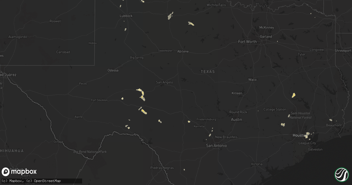
Hail Map in Texas on August 10, 2018
Get this storm
August 10 map
$229
one time, instant access
Download today. No call, no setup
Keep the $229
Bought the map and want the full workflow? Apply the entire $229 to a subscription within 7 days. None of it is wasted.
Every map, not just this one
This buys you this map. Subscription and you get every map we run, in the markets you choose from a few cities to whole states to nationwide. Plus real-time alerts the moment a storm fires.
Contact data
Name, contact info, occupancy, even credit band for addresses in the footprint. You go from where it hit to who to call.
Become the source they trust
Unlimited branding weather history reports on demand. You already have the documented answer ready for the property owner, and you are the one who showed up with it.
Property data and RoofTrace estimates
Pull up any address you have got, its value and the exact code rules for that jurisdiction, straight from One Click Code. Then RoofTrace estimates the squares, pitch, and roof value, priced the way you price.
Storm reports in Texas
Texas
| Date | Description |
|---|---|
| 08/10/20184:55 PM CDT | A local report indicates 58 MPH wind near 6 SSW ANTON |
| 08/10/20184:54 PM CDT | Powerlines down on two cars in crosby on bridge over the san jacinto river. Report relayed via local media. |
| 08/10/20183:13 PM CDT | Several large tree limbs down... Awning blown off... And some roof damage in downtown atlanta. |
| 08/10/20182:45 PM CDT | A local report indicates 58 MPH wind near 6 SSW ANTON |
| 08/10/20183:27 AM CDT | At 827 PM CDT, a severe thunderstorm was located near Lovelady, or 11 miles southeast of Austonio, moving northeast at 35 mph. HAZARD...60 mph wind gusts and quarter size hail. SOURCE...Radar indicated. IMPACT...Hail damage to vehicles is expected. Expect wind damage to roofs, siding, and trees. Locations impacted include... Crockett and Lovelady. |
| 08/10/201812:10 AM CDT | At 509 PM CDT, a severe thunderstorm was located 4 miles northwest of Shallowater, or 13 miles southwest of Abernathy, moving southeast at 25 mph. HAZARD...60 mph wind gusts. SOURCE...Radar indicated. IMPACT...Expect damage to roofs, siding, and trees. Locations impacted include... Lubbock, Abernathy, Wolfforth, Shallowater, Lubbock South Plains Mall, Lubbock International Airport, Texas Tech University, Slide, Downtown Lubbock, Reese Center, New Deal, Smyer and Lubbock Science Spectrum. |
| 08/09/201810:29 PM CDT | At 328 PM CDT, a severe thunderstorm was located 7 miles northwest of Halfway, or 7 miles northeast of Olton, moving southwest at 20 mph. HAZARD...60 mph wind gusts and nickel size hail. SOURCE...Radar indicated. IMPACT...Expect damage to roofs, siding, and trees. Locations impacted include... Olton, Earth, Cotton Center, Halfway, Edmonson and Springlake. |
| 08/09/20189:23 PM CDT | At 222 PM CDT, a severe thunderstorm was located 12 miles south of Ozona, moving east at 20 mph. HAZARD...60 mph wind gusts and quarter size hail. SOURCE...Radar indicated. IMPACT...Hail damage to vehicles is expected. Expect wind damage to roofs, siding, and trees. This severe thunderstorm will remain over mainly rural areas of southeastern Crockett County, including the following locations... The Intersection Of Highway 163 And Ranch Road 1973 and I-10 Near The Crockett-Sutton County Line.This includes Interstate 10 between Mile Markers 375 and 379. |
| 08/09/20188:10 PM CDT | At 110 PM CDT, a severe thunderstorm was located near Barnhart, or 19 miles southeast of Big Lake, moving southeast at 30 mph. HAZARD...60 mph wind gusts and quarter size hail. SOURCE...Radar indicated. IMPACT...Hail damage to vehicles is expected. Expect wind damage to roofs, siding, and trees. This severe thunderstorm will remain over mainly rural areas of northwestern Schleicher...northeastern Crockett and south central Irion Counties, including the following locations... Us-190 Near The Crockett-Sutton County Line and The Intersection Of Us 190 And Highway 163. |
All States Impacted by Hail Map on August 10, 2018
Cities Impacted by Hail Map on August 10, 2018
- Bourbon, MO
- Sullivan, MO
- Big Lake, TX
- Cimarron, NM
- Lovelady, TX
- Williams, AZ
- Farwell, TX
- Castleberry, AL
- Evergreen, AL
- Lucedale, MS
- Roosevelt, AZ
- Woodward, OK
- Mooreland, OK
- West Milton, OH
- Troy, OH
- Ludlow Falls, OH
- Fairfax, OK
- Ozona, TX
- Grenola, KS
- Paducah, TX
- Haskell, TX
- Weinert, TX
- Throckmorton, TX
- Lecompte, LA
- Laverne, OK
- Fort Mcdowell, AZ
- Troy, NC
- Star City, IN
- Lebanon, MO
- New London, NC
- Mico, TX
- Saint Charles, MO
- Glencoe, OK
- Stillwater, OK
- Payson, AZ
- Kress, TX
- Olton, TX
- Plainview, TX
- Friona, TX
- Muleshoe, TX
- Ash Fork, AZ
- Portland, MO
- Indianola, IL
- Bingham, IL
- Ramsey, IL
- Fillmore, IL
- Ozark, MO
- Iraan, TX
- Boerne, TX
- Fall River, KS
- Happy Jack, AZ
- Sedona, AZ
- Andalusia, AL
- Maryland Heights, MO
- Saint Louis, MO
- Syracuse, MO
- Otterville, MO
- Ionia, MO
- Defiance, MO
- Augusta, MO
- New Florence, MO
- Arcadia, OK
- Canute, OK
- Elk City, OK
- Biscoe, NC
- Carthage, NC
- West End, NC
- Toronto, KS
- Yates Center, KS
- Virgil, KS
- Fairmount, IL
- Fithian, IL
- Arcadia, KS
- Concordia, MO
- Skiatook, OK
- Sapulpa, OK
- Sand Springs, OK
- Springfield, MO
- Hiko, NV
- Arcola, IL
- Humboldt, IL
- Charleston, IL
- Lamar, MO
- Douglass, KS
- Cowden, IL
- Warrensburg, MO
- Leon, KS
- Prue, OK
- Globe, AZ
- Guthrie, OK
- Medaryville, IN
- Bolivar, MO
- Pleasant Hope, MO
- Cubero, NM
- Seligman, AZ
- Ponderosa, NM
- Eagle Springs, NC
- Robbins, NC
- Call, TX
- Custer City, OK
- Camden, AL
- Shelbyville, IL
- Perryton, TX
- Morocco, IN
- Russiaville, IN
- Butler, OK
- Goshen, AL
- Luverne, AL
- Severy, KS
- Piedmont, KS
- Clayton, OK
- Deer Park, TX
- Young, AZ
- Williamsport, OH
- New Holland, OH
- Ashland, KS
- Hurdland, MO
- Troy, AL
- Glenwood, AL
- Brookline, MO
- Tucson, AZ
- Cameron, NC
- El Reno, OK
- Howard, KS
- Abernathy, TX
- Pawhuska, OK
- Oklahoma City, OK
- Bethany, OK
- Tonto Basin, AZ
- Barnhart, TX
- Attica, IN
- Fouke, AR
- Crystal Springs, MS
- Terry, MS
- Utica, MS
- Higginsville, MO
- Corder, MO
- Rhineland, MO
- Baytown, TX
- La Porte, TX
- Seabrook, TX
- Sayre, OK
- Cincinnati, OH
- Wichita, KS
- Haysville, KS
- Hazlehurst, MS
- Church Point, LA
- Florence, MO
- Saint Ann, MO
- Bridgeton, MO
- Colorado City, AZ
- Floydada, TX
- Humansville, MO
- Dadeville, MO
- Jerico Springs, MO
- El Dorado Springs, MO
- Walnut Grove, MO
- Everton, MO
- Aldrich, MO
- Miami, AZ
- Amoret, MO
- Belen, NM
- Amherst, TX
- Chesterfield, MO
- Wildwood, MO
- Freedom, OK
- Greenwood, MO
- Pleasant Hill, MO
- Lees Summit, MO
- Hart, TX
- Hillsboro, IL
- Butler, IL
- Pleasanton, KS
- Amsterdam, MO
- Barnsdall, OK
- Beggs, OK
- Milo, MO
- Nevada, MO
- Ponca City, OK
- Hempstead, TX
- Waller, TX
- Prairie View, TX
- Okemah, OK
- Warner Robins, GA
- Montgomery, TX
- Holden, MO
- Saint Albans, MO
- Show Low, AZ
- Matador, TX
- Fordland, MO
- Sparta, MO
- Bruner, MO
- Seymour, MO
- Macy, IN
- Brewton, AL
- Rensselaer, IN
- Knob Noster, MO
- La Monte, MO
- Sweet Springs, MO
- Roann, IN
- Denver, IN
- Enterprise, UT
- Enid, OK
- Steedman, MO
- Scottsdale, AZ
- Cave Creek, AZ
- Los Alamos, NM
- White Rock, NM
- Oakland, IL
- East Carondelet, IL
- Dupo, IL
- Alabaster, AL
- Pelham, AL
- Burbank, OK
- Fountain Hills, AZ
- Dryden, TX
- Windsor, IL
- Richton, MS
- Montrose, MO
- Butler, MO
- Appleton City, MO
- Sheldon, MO
- Granite City, IL
- Collinsville, IL
- Saint Peters, MO
- Madison, IL
- O'Fallon, IL
- Phoenix, AZ
- Gotebo, OK
- Hobart, OK
- Roosevelt, OK
- Half Way, MO
- Circleville, OH
- Pacific, MO
- Bessemer, AL
- McCalla, AL
- Overgaard, AZ
- Wilson, TX
- Pasadena, TX
- Cache, OK
- Lawton, OK
- Stockton, AL
- Millersburg, OH
- Comstock, TX
- Wynona, OK
- Kellyville, OK
- Ralston, OK
- Ashburn, GA
- Lacombe, LA
- Saint Anne, IL
- Junction, TX
- Helena, AL
- Barnett, MO
- Melrose, NM
- Rattan, OK
- Groom, TX
- Hamilton, KS
- Tulia, TX
- Winamac, IN
- Vidor, TX
- Wright City, OK
- Mustang, OK
- Yukon, OK
- Black Canyon City, AZ
- Republic, MO
- Logansport, IN
- Seminary, MS
- Hattiesburg, MS
- Balko, OK
- Defuniak Springs, FL
- Ponce De Leon, FL
- Bristow, OK
- Mount Gilead, NC
- Star, NC
- Candor, NC
- Deepwater, MO
- Lowry City, MO
- Hermann, MO
- Houston, TX
- Highlands, TX
- Channelview, TX
- Annona, TX
- Clarksville, TX
- Twelve Mile, IN
- Lumberton, TX
- Silsbee, TX
- Rogersville, MO
- Palm Beach Gardens, FL
- Jupiter, FL
- Singer, LA
- Taylor, AR
- Mcalester, OK
- High Hill, MO
- Leedey, OK
- Taloga, OK
- Saint Stephens, AL
- Ballwin, MO
- Columbia City, IN
- Napoleon, MO
- Fieldton, TX
- Union City, OK
- Franklin, AL
- Chilhowee, MO
- Bois D Arc, MO
- Willard, MO
- Nixa, MO
- Eldon, MO
- Rockdale, TX
- Garden City, MO
- Minco, OK
- Paradise Valley, AZ
- Rocksprings, TX
- Canadian, TX
- Villa Ridge, MO
- Bovina, TX
- Vernon, CO
- Costilla, NM
- Silverton, TX
- El Dorado, AR
- Booker, TX
- Plaucheville, LA
- Tahoka, TX
- Mason, OH
- Paulden, AZ
- Miamiville, OH
- Terrace Park, OH
- Loveland, OH
- Camp Dennison, OH
- Milford, OH
- Farlington, KS
- Byram, MS
- Sedalia, MO
- Nilwood, IL
- Lake Charles, LA
- Sulphur, LA
- Wing, AL
- Eureka, MO
- Hale Center, TX
- Stockton, MO
- Wray, CO
- Gays, IL
- Crosby, MS
- Vass, NC
- Sanford, NC
- Jackson Springs, NC
- Buena Vista, NM
- Cambridge, KS
- Laurel Hill, FL
- Harrisonburg, LA
- Warwick, GA
- Arabi, GA
- Terrell, TX
- Francesville, IN
- Sullivan, IL
- Alva, OK
- Big Wells, TX
- Crystal City, TX
- Green Ridge, MO
- McIntosh, AL
- Stuart, FL
- Heber, AZ
- Pearl River, LA
- Ville Platte, LA
- Crosby, TX
- O'Fallon, MO
- Citronelle, AL
- Frankfort, IN
- Avery, TX
- Lahoma, OK


