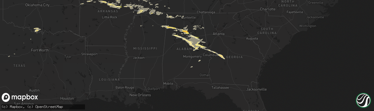
Hail Map in Alabama on August 9, 2023
The weather event in Alabama on August 9, 2023 includes Wind and Hail maps. 17 states and 526 cities were impacted and suffered possible damage. The total estimated number of properties impacted is 27,653.
Want more than just the map?
Turn this storm into a full workflow.
- Owner + property data so you know who to knock
- OnDemand branded weather history reports to win the "did we even have hail?" argument
- RoofTrace estimate so reps stop guessing numbers at the door
Bought this map? Upgrade within 7 days and we'll credit the $230. (10-15 min setup call)
Wind
Hail
27,653
Estimated number of impacted properties by a 1.00" hail or larger3,754
Estimated number of impacted properties by a 1.75" hail or larger0
Estimated number of impacted properties by a 2.50" hail or largerStorm reports in Alabama
Alabama
| Date | Description |
|---|---|
| 08/09/20236:35 PM CDT | Tree down on 2nd street nw in hamilton. |
| 08/09/20236:35 PM CDT | Tree down on cr-1... North of hamilton. |
| 08/09/20236:30 PM CDT | Corrects time of previous tstm wnd dmg report from 1 nw pell city. Trees were blown down in the harrisburg area of pell city. |
| 08/09/20236:06 PM CDT | Tree on the road near the intersection of us hwy 78 and koa road. |
| 08/09/20236:06 PM CDT | Trees down on us hwy 78... Near koa road and seddon road. |
| 08/09/20235:42 PM CDT | Tree blown down at 281 industrial lane in sylvania. |
| 08/09/20235:37 PM CDT | Tree blown down across cr 89 near mentone. |
| 08/09/20235:33 PM CDT | A local report indicates 1.75 inch wind near 1 WNW Hayden |
| 08/09/20235:29 PM CDT | A local report indicates 1.00 inch wind near 1 E Hayden |
| 08/09/20235:23 PM CDT | Pics from smoke rise. |
| 08/09/20235:22 PM CDT | Several trees down on pine mountain road near remlap... Al. |
| 08/09/20235:22 PM CDT | Tree blown down across cr 380 in dutton. |
| 08/09/20235:21 PM CDT | Tree blown down in the 3500 block of cr 265 in section. |
| 08/09/20235:17 PM CDT | A local report indicates 1.25 inch wind near Rickwood Caverns |
| 08/09/20234:25 PM CDT | A tree was blown down and blocking the roadway. |
| 08/09/20234:06 PM CDT | Powerlines and transformer down. |
| 08/09/20234:01 PM CDT | Tree with power lines down on spring street in hamilton... Al. |
| 08/09/20233:59 PM CDT | Tree blown down across u.s. 72 west of the elk river bridge. |
| 08/09/20233:06 PM CDT | Large tree snapped. |
| 08/09/20239:28 AM CDT | A carport sustained damage on cedar creek drive... Near talladega springs. |
| 08/09/20236:17 AM CDT | Tree down on bridge at cr-395 and cr-51. |
| 08/09/20235:15 AM CDT | Trees down over roadway at 200 blk cr-59 near dutton. |
| 08/09/20235:15 AM CDT | Tree down near dawson area at cr-199 and cr-196 reported by crossville fire department. |
| 08/09/20235:03 AM CDT | Tree limbs down over roadway. |
| 08/09/20234:59 AM CDT | Tree down at cr 140 between cr 788 and al 75. |
| 08/09/20234:41 AM CDT | Powerlines down at 328 cr 53 in crossville. |
| 08/09/20234:41 AM CDT | Trees down on roadway at cr 57 and cr 62. |
| 08/09/20234:41 AM CDT | Tree down at 961 cr 30 in collinsville. |
| 08/09/20234:41 AM CDT | Tree down along parker st. |
| 08/09/20234:41 AM CDT | Tree down on powerline and roadway between cr 20 and cr 843 near dawson. |
| 08/09/20234:35 AM CDT | Tree blocking roadway near 1059 cr-43. |
| 08/09/20234:35 AM CDT | Powerlines down at 4542 cr 83 in collinsville near cherokee county line. |
| 08/09/20234:24 AM CDT | Trees down at fry gap rd near arab. |
| 08/09/20234:24 AM CDT | Multiple trees down at cr 67 in langston near the post office. |
| 08/09/20234:14 AM CDT | Tree down at cornerstone dr near cr 732 and cr 764 in henagar. |
| 08/09/20234:10 AM CDT | Large tree down at county rd 16 in dutton. |
| 08/09/20234:10 AM CDT | Trees and powerlines down at us 11 and county rd. 30 near downtown collinsville. |
| 08/09/20234:10 AM CDT | Tree down at hwy 205 and summerville rd. |
| 08/09/20234:08 AM CDT | A tree branch was blown down onto power lines on 2nd avenue w in oneonta... Near the entrance to the hospital. |
| 08/09/20234:07 AM CDT | Tree down at al-68 and justice st. |
| 08/09/20233:50 AM CDT | Tree down at 642 cr-295. |
| 08/09/20233:50 AM CDT | Tree down on powerlines on cr-396. |
| 08/09/20233:50 AM CDT | Multiple trees down on tupelo dr. |
| 08/09/20233:50 AM CDT | Tress down at cr 77 near hwy 79. |
| 08/09/20233:50 AM CDT | Corrects previous tstm wnd dmg report from 5 n ider. Tree down at cr 326 and cr 709 near flat rock. |
| 08/09/20233:47 AM CDT | Tree down on roadway. |
| 08/09/20233:44 AM CDT | Tree down on residence... Damage to carport and two vehicles. |
| 08/09/20233:35 AM CDT | Trees and limbs were blown down. |
| 08/09/20233:05 AM CDT | Damage to farm buildings and trees. Roofing and siding scattered along with horse trailer flipped. |
| 08/09/20233:00 AM CDT | Several tree limbs down along with some home siding damage. |
| 08/09/20232:57 AM CDT | Asos station khsv huntsville. |
| 08/09/20232:56 AM CDT | Tree down at indigo at grissom apartments near meadowbrook drive in south huntsville. Report and photo from social media. Time estimated from radar. |
| 08/09/20232:52 AM CDT | Public report of several trees uprooted and snapped on the redstone arsenal at vincent dr and phoenix rd. Time estimated by radar. |
| 08/09/20232:50 AM CDT | Tree down on powerlines on todd mill rd. |
| 08/09/20232:07 AM CDT | Report of large tree limbs snapped nw of rogersville. |
| 08/08/202310:40 PM CDT | Ping pong sized hail reported in the willow point/our town area. |
| 08/08/20239:55 PM CDT | Quarter size hail near hanover. |
| 08/08/20239:28 PM CDT | Corrects time of previous tstm wnd dmg report from 2 wnw fayetteville. A carport sustained damage on cedar creek drive... Near talladega springs. |
| 08/08/20239:27 PM CDT | A local report indicates 1.50 inch wind near Fayetteville |
| 08/08/20239:00 PM CDT | Quarter sized hail reported in chelsea. |
| 08/08/20238:50 PM CDT | Large tree was blown down on old highway 280 near mountain crest road... Northwest of chelsea. |
| 08/08/20238:36 PM CDT | A tree was blown down near cox lane and wolf creek road. |
| 08/08/20238:31 PM CDT | Half dollar sized hail on everglade road... Near daviston. Pictures on social media. |
| 08/08/20238:00 PM CDT | A tree was blown down and landed on a home near lake drive. |
| 08/08/20237:30 PM CDT | Corrects previous tstm wnd dmg report from 3 wnw corinth. Trees down on cr-29... Near fosters crossroads. |
| 08/08/20237:21 PM CDT | A tree was blown down and blocking the roadway on dorning road near trafford. |
| 08/08/20237:20 PM CDT | Trees were blown down on cr-313... Near cr-82. |
| 08/08/20237:19 PM CDT | Quarter sized hail in munford. Pictures on social media. |
| 08/08/20237:15 PM CDT | Tree blown down onto powerlines on elvester road... Northeast of warrior. |
| 08/08/20237:13 PM CDT | Trees down over the northern part of randolph county... Generally between county road 29 and county road 313. |
| 08/08/20237:11 PM CDT | A local report indicates 1.25 inch wind near 2 W Russell Field Airpo |
All States Impacted by Hail Map on August 9, 2023
Cities Impacted by Hail Map on August 9, 2023
- Nekoma, KS
- Otis, KS
- Rush Center, KS
- Larned, KS
- Albert, KS
- Rozel, KS
- Pawnee Rock, KS
- Great Bend, KS
- Bison, KS
- La Crosse, KS
- Alexander, KS
- Burdett, KS
- Bazine, KS
- Ness City, KS
- Memphis, TN
- Eads, CO
- Sheridan Lake, CO
- Trumann, AR
- Marked Tree, AR
- Tyronza, AR
- Turrell, AR
- Moscow, TN
- Earle, AR
- Gilmore, AR
- Eden Valley, MN
- Williston, TN
- Somerville, TN
- Millington, TN
- Heth, AR
- Widener, AR
- Lamar, CO
- Lake Cormorant, MS
- Marion, AR
- Omaha, AR
- Cordova, TN
- Walls, MS
- Tribune, KS
- Drummonds, TN
- Paynesville, MN
- Kit Carson, CO
- Fisher, AR
- Hickory Ridge, AR
- Harrisburg, AR
- Cherry Valley, AR
- Hughes, AR
- Eads, TN
- Arlington, TN
- Germantown, TN
- Collierville, TN
- Oakland, TN
- West Memphis, AR
- Rossville, TN
- Cheyenne Wells, CO
- Crawfordsville, AR
- Proctor, AR
- Whiteville, TN
- Bolivar, TN
- Grand Junction, TN
- Hickory Valley, TN
- Hanceville, AL
- Bremen, AL
- Hayden, AL
- Warrior, AL
- Lynn, AL
- Haleyville, AL
- Trafford, AL
- Remlap, AL
- Nowata, OK
- Locust Fork, AL
- Pinson, AL
- Kimberly, AL
- Springville, AL
- Trussville, AL
- Goodwater, AL
- Alexander City, AL
- Ashland, AL
- Cragford, AL
- Millerville, AL
- Talladega, AL
- Talala, OK
- Daviston, AL
- Berry, AL
- Oakman, AL
- Michigan City, MS
- Dafter, MI
- Barbeau, MI
- Welch, OK
- Rutledge, AL
- Luverne, AL
- Walnut, MS
- Lamar, MS
- Corinth, MS
- Sault Sainte Marie, MI
- Miami, OK
- Fairland, OK
- Aurora, MO
- Verona, MO
- Detroit, AL
- Hamilton, AL
- Morland, KS
- Penokee, KS
- Winslow, AZ
- Leupp, AZ
- Kinross, MI
- Brimley, MI
- Leighton, AL
- Saint Johns, AZ
- Fulton, MS
- Nettleton, MS
- Cherokee, AL
- Tuscumbia, AL
- Florence, AL
- Saulsbury, TN
- Middleton, TN
- La Grange, TN
- Guin, AL
- Little Falls, MN
- Pawhuska, OK
- Pocahontas, TN
- Tiplersville, MS
- Ramer, TN
- Barronett, WI
- Cumberland, WI
- Rudyard, MI
- Pickford, MI
- Kincheloe, MI
- Smithville, MS
- Tremont, MS
- Cape Fair, MO
- Galena, MO
- Muscle Shoals, AL
- Iuka, MS
- Sheffield, AL
- Shell Lake, WI
- Rice Lake, WI
- Holcombe, WI
- Reserve, NM
- Bartlesville, OK
- Monett, MO
- Purdy, MO
- Neosho, MO
- Ashland, MS
- Falkner, MS
- Joplin, MO
- Seneca, MO
- Snowflake, AZ
- Chelsea, OK
- Claremore, OK
- Oologah, OK
- Branson, MO
- Reeds Spring, MO
- Walnut Shade, MO
- Rockaway Beach, MO
- Forsyth, MO
- Kissee Mills, MO
- Taneyville, MO
- Rueter, MO
- Bradleyville, MO
- Theodosia, MO
- Isabella, MO
- Thornfield, MO
- Gainesville, MO
- Pontiac, MO
- Mountain Home, AR
- Oakland, AR
- Protem, MO
- Camp Hill, AL
- Birmingham, AL
- Bessemer, AL
- Fairfield, AL
- Dolomite, AL
- Pelham, AL
- Chelsea, AL
- Columbiana, AL
- Wilsonville, AL
- Childersburg, AL
- Sylacauga, AL
- Weogufka, AL
- Rockford, AL
- Lafayette, AL
- Clarkridge, AR
- Gamaliel, AR
- Udall, MO
- Bakersfield, MO
- Hardenville, MO
- Peel, AR
- Midway, AR
- Lakeview, AR
- Gassville, AR
- Henderson, AR
- Gepp, AR
- Elizabeth, AR
- Calico Rock, AR
- Norfork, AR
- Dolph, AR
- Pineville, AR
- Bexar, AR
- Wideman, AR
- Viola, AR
- Salem, AR
- Violet Hill, AR
- Wiseman, AR
- Oxford, AR
- Horseshoe Bend, AR
- Billings, MO
- Clever, MO
- Highlandville, MO
- Graham, TX
- Ellerslie, GA
- Cataula, GA
- Henning, TN
- Ripley, TN
- Luxora, AR
- Koshkonong, MO
- Pocahontas, AR
- Imboden, AR
- Chestnutridge, MO
- Union Springs, AL
- Hector, AR
- Wilson, OK
- Green Forest, AR
- Alpena, AR
- Vinita, OK
- Bluejacket, OK
- Kellyton, AL
- Fairview, MO
- Stark City, MO
- Granby, MO
- Wyandotte, OK
- Rogers, AR
- Eureka Springs, AR
- Huntsville, AR
- Lead Hill, AR
- Paragould, AR
- Brookland, AR
- Moran, TX
- Ash Flat, AR
- Tecumseh, MO
- Squires, MO
- Noble, MO
- Wasola, MO
- Ava, MO
- Caulfield, MO
- Aberdeen, SD
- Walnut Ridge, AR
- Nauvoo, AL
- Afton, OK
- Grove, OK
- Anderson, MO
- Mountain View, AR
- Ringling, OK
- Nocona, TX
- Saint Jo, TX
- Western Grove, AR
- Jasper, AR
- Hasty, AR
- Parthenon, AR
- Vendor, AR
- Pleasant Grove, AL
- Lineville, AL
- Hamilton, GA
- Fortson, GA
- West Point, GA
- Valley, AL
- Pell City, AL
- Flagstaff, AZ
- Deer, AR
- Double Springs, AL
- Brilliant, AL
- Bear Creek, AL
- Winfield, AL
- Garfield, AR
- Rocky Comfort, MO
- Washburn, MO
- Powell, MO
- Stella, MO
- Seligman, MO
- Pineville, MO
- Osceola, AR
- Alma, AR
- Rudy, AR
- Dewey, OK
- Adger, AL
- Quinton, AL
- Carbon Hill, AL
- Eldridge, AL
- Marble Falls, AR
- Jasper, AL
- Morris, AL
- Ramona, OK
- Adair, OK
- Cullman, AL
- Ozark, MO
- Cassville, MO
- Exeter, MO
- Wadley, AL
- Lincoln, AL
- Blytheville, AR
- Riverside, AL
- Odenville, AL
- Eastaboga, AL
- Cropwell, AL
- Munford, AL
- Harrison, AR
- Saint Joe, AR
- Gilbert, AR
- Kingston, AR
- Harriet, AR
- Marshall, AR
- Ponca, AR
- Onia, AR
- Compton, AR
- Mount Judea, AR
- Big Flat, AR
- Ravenden, AR
- Smithville, AR
- Bono, AR
- Glencoe, AR
- Powhatan, AR
- Poughkeepsie, AR
- Alicia, AR
- Cherokee Village, AR
- Black Rock, AR
- Williford, AR
- Hoxie, AR
- Hardy, AR
- Evening Shade, AR
- Portia, AR
- Jonesboro, AR
- Diamond, MO
- Fayette, AL
- Mulga, AL
- Parrish, AL
- Bankston, AL
- Northport, AL
- Socorro, NM
- Equality, AL
- Hagarville, AR
- Dell, AR
- Leachville, AR
- Blountsville, AL
- Lake City, AR
- Black Oak, AR
- Bay, AR
- Harpersville, AL
- Clyde, TX
- Abilene, TX
- Cornville, AZ
- Ash Fork, AZ
- Bowie, TX
- Manila, AR
- Dadeville, AL
- Moody, AL
- Delta, AL
- Vero Beach, FL
- Alpine, AL
- Sterrett, AL
- Vincent, AL
- Wetumpka, AL
- Okeechobee, FL
- Wedowee, AL
- Beech Grove, AR
- Williams, AZ
- South West City, MO
- Noel, MO
- Burneyville, OK
- Ryan, OK
- Overbrook, OK
- Strawberry, AR
- State University, AR
- Mammoth Spring, AR
- Camp, AR
- Lynn, AR
- Roanoke, AL
- Berryville, AR
- Van Buren, AR
- Leola, SD
- Westport, SD
- Leon, OK
- Gardendale, AL
- Fitzpatrick, AL
- Waverly Hall, GA
- Goodman, MO
- Fort Pierce, FL
- Beaverton, AL
- Vina, AL
- Arley, AL
- Sulligent, AL
- Crane Hill, AL
- Lanett, AL
- Leeds, AL
- Midland, GA
- Eclectic, AL
- Cusseta, AL
- Titus, AL
- Jacksons Gap, AL
- Ragland, AL
- Franklin, AR
- Ravenden Springs, AR
- O'Kean, AR
- Delaplaine, AR
- Monette, AR
- Caraway, AR
- Etowah, AR
- Searcy, AR
- Judsonia, AR
- Bald Knob, AR
- Russell, AR
- Montezuma, GA
- Everton, AR
- McCrory, AR
- Newport, AR
- Quitman, AR
- Shirley, AR
- Higden, AR
- Bee Branch, AR
- Clinton, AR
- Timbo, AR
- Pleasant Plains, AR
- Floral, AR
- Brownsville, TN
- Pleasant Grove, AR
- Butler, GA
- Ideal, GA
- Rupert, GA
- Ellaville, GA
- Oglethorpe, GA
- Mauk, GA
- Reynolds, GA
- Byromville, GA
- Ozark, AR
- Batesville, AR
- Parkin, AR
- Wynne, AR
- Melbourne, AR
- Mount Pleasant, AR
- Fifty Six, AR
- Guion, AR
- Olivehill, TN
- Jerusalem, AR
- Heber Springs, AR
- Pettigrew, AR
- Saint Paul, AR
- Pontotoc, MS
- Box Springs, GA
- Shelby, AL
- Augusta, AR
- Combs, AR
- Winslow, AR
- Tumbling Shoals, AR
- Witts Springs, AR
- Wilburn, AR
- Concord, AR
- Tilly, AR
- Ida, AR
- Letona, AR
- Leslie, AR
- Rose Bud, AR
- Pangburn, AR
- Choctaw, AR
- Kensett, AR
- Scotland, AR
- Drasco, AR
- Pelsor, AR
- Bradford, AR
- Clarksville, AR
- Ozone, AR
- Desha, AR
- Locust Grove, AR
- Bassett, AR
- Joiner, AR
- Frenchmans Bayou, AR
- Stanton, TN
- Marcella, AR
- Oark, AR
- Henderson, TN
- Flippin, AR
- Yellville, AR
- Toone, TN
- Medon, TN
- Pinson, TN
- Jackson, TN
- Mercer, TN
- Southaven, MS
- Horn Lake, MS
- Sardis, TN
- Saltillo, TN
- Upatoi, GA
- Junction City, GA
- Alabaster, AL
- Andersonville, GA
- Buena Vista, GA
- Waynesboro, TN
- Athens, AL
- Dora, AL
- Sumiton, AL
- Rogersville, AL
- Collinsville, AL
- Gadsden, AL
- Attalla, AL
- Boaz, AL
- Cedar Bluff, AL
- Leesburg, AL
- Plantersville, MS
- Courtland, MS
- Centre, AL
- Holly Pond, AL
- Romance, AR
- Piedmont, AL
- Weiner, AR
- Amagon, AR
- Tanner, AL
- Pope, MS
- Batesville, MS
- Cleveland, AL
- Greenwood Springs, MS
- Gallant, AL
- Altoona, AL
- Empire, AL
- Crossville, AL
- Town Creek, AL
- Killen, AL
- Rosie, AR
- Oil Trough, AR
- Cordova, AL
- Graysville, AL


