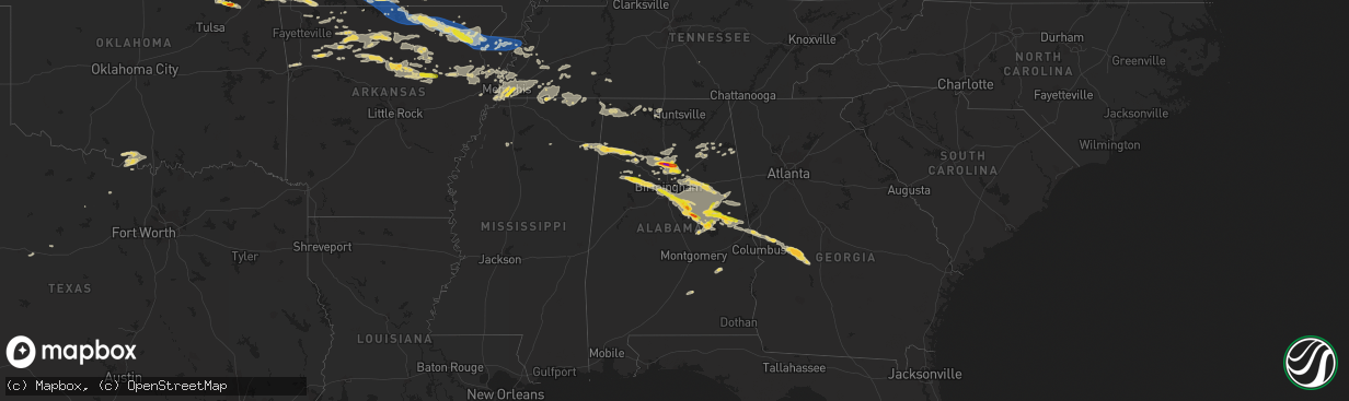
Hail Map on August 9, 2023
The weather event on August 9, 2023 includes Wind and Hail maps. 17 states and 526 cities were impacted and suffered possible damage. The total estimated number of properties impacted is 53,139.
Want more than just the map?
Turn this storm into a full workflow.
- Owner + property data so you know who to knock
- OnDemand branded weather history reports to win the "did we even have hail?" argument
- RoofTrace estimate so reps stop guessing numbers at the door
Bought this map? Upgrade within 7 days and we'll credit the $230. (10-15 min setup call)
Wind
Hail
53,139
Estimated number of impacted properties by a 1.00" hail or larger3,864
Estimated number of impacted properties by a 1.75" hail or larger0
Estimated number of impacted properties by a 2.50" hail or largerStates Impacted by Hail Map on August 9, 2023
Storm reports
Oklahoma
| Date | Description |
|---|---|
| 08/09/20236:46 PM CDT | Storage shed damaged. |
| 08/09/20236:40 PM CDT | Portions of a roof removed from a residence. Time is estimated via radar. |
| 08/09/20236:30 PM CDT | Power pole blown down. Time estimated via radar. |
| 08/08/20237:20 PM CDT | Power poles blown down in the enos and buncombe creek communities. Time estimated via radar. |
Tennessee
| Date | Description |
|---|---|
| 08/09/20233:01 PM CDT | Trees 12 inch in diameter down on road in area of ward road and busby road. Road blockage. |
| 08/09/20232:59 PM CDT | Trees across roads west of loretto around thornton road. |
| 08/09/20232:12 PM CDT | Reported tree down. |
| 08/09/20231:15 PM CDT | Herrington creek was out of its banks and flooding nearby parking lot near stage rd. |
| 08/09/202311:47 AM CDT | Major tree damage in sherwood forest area of east memphis. |
| 08/09/202311:45 AM CDT | Reported hail near walnut grove and white station. |
| 08/09/202311:40 AM CDT | Corrects previous hail report from 3 nne southeast memphis. Reported hail near walnut grove and white station. |
| 08/09/202311:27 AM CDT | Quarter size hail reported at the university of memphis. |
| 08/09/202311:25 AM CDT | Quarter size hail reported near lamar ave and i-240. |
| 08/09/202311:25 AM CDT | Corrects previous tstm wnd dmg report from 3 se midtown memphis. Major tree damage in sherwood forest area of east memphis. Microburst detected via radar. |
| 08/09/20234:25 AM CDT | Several trees down across the county. |
| 08/09/20233:40 AM CDT | Several trees down. |
| 08/09/20232:50 AM CDT | Trees down at chestnut ridge rd and stewart hollow rd. |
| 08/09/20232:50 AM CDT | Trees down at 7018 charity rd. |
| 08/09/20232:50 AM CDT | Tree down at 1087 stewart hollow rd. |
| 08/09/20232:50 AM CDT | Tree down at culberland springs rd and raysville rd. |
| 08/09/20232:50 AM CDT | Trees down on hurrican creek road. |
| 08/09/20232:50 AM CDT | Trees down along ray burton rd. |
| 08/09/20232:36 AM CDT | Facebook photos showed a tree fell on a house near sparta. |
| 08/09/20231:22 AM CDT | Tspotter coordinator sent photo of a large cedar tree split on ellendale drive. |
| 08/08/202311:20 PM CDT | Several fallen trees knocking down powerlines/power across ripley... Tn reported. |
Alabama
| Date | Description |
|---|---|
| 08/09/20236:35 PM CDT | Tree down on cr-1... North of hamilton. |
| 08/09/20236:35 PM CDT | Tree down on 2nd street nw in hamilton. |
| 08/09/20236:30 PM CDT | Corrects time of previous tstm wnd dmg report from 1 nw pell city. Trees were blown down in the harrisburg area of pell city. |
| 08/09/20236:06 PM CDT | Trees down on us hwy 78... Near koa road and seddon road. |
| 08/09/20236:06 PM CDT | Tree on the road near the intersection of us hwy 78 and koa road. |
| 08/09/20235:42 PM CDT | Tree blown down at 281 industrial lane in sylvania. |
| 08/09/20235:37 PM CDT | Tree blown down across cr 89 near mentone. |
| 08/09/20235:33 PM CDT | A local report indicates 1.75 inch wind near 1 WNW Hayden |
| 08/09/20235:29 PM CDT | A local report indicates 1.00 inch wind near 1 E Hayden |
| 08/09/20235:23 PM CDT | Pics from smoke rise. |
| 08/09/20235:22 PM CDT | Tree blown down across cr 380 in dutton. |
| 08/09/20235:22 PM CDT | Several trees down on pine mountain road near remlap... Al. |
| 08/09/20235:21 PM CDT | Tree blown down in the 3500 block of cr 265 in section. |
| 08/09/20235:17 PM CDT | A local report indicates 1.25 inch wind near Rickwood Caverns |
| 08/09/20234:25 PM CDT | A tree was blown down and blocking the roadway. |
| 08/09/20234:06 PM CDT | Powerlines and transformer down. |
| 08/09/20234:01 PM CDT | Tree with power lines down on spring street in hamilton... Al. |
| 08/09/20233:59 PM CDT | Tree blown down across u.s. 72 west of the elk river bridge. |
| 08/09/20233:06 PM CDT | Large tree snapped. |
| 08/09/20239:28 AM CDT | A carport sustained damage on cedar creek drive... Near talladega springs. |
| 08/09/20236:17 AM CDT | Tree down on bridge at cr-395 and cr-51. |
| 08/09/20235:15 AM CDT | Tree down near dawson area at cr-199 and cr-196 reported by crossville fire department. |
| 08/09/20235:15 AM CDT | Trees down over roadway at 200 blk cr-59 near dutton. |
| 08/09/20235:03 AM CDT | Tree limbs down over roadway. |
| 08/09/20234:59 AM CDT | Tree down at cr 140 between cr 788 and al 75. |
| 08/09/20234:41 AM CDT | Powerlines down at 328 cr 53 in crossville. |
| 08/09/20234:41 AM CDT | Tree down at 961 cr 30 in collinsville. |
| 08/09/20234:41 AM CDT | Trees down on roadway at cr 57 and cr 62. |
| 08/09/20234:41 AM CDT | Tree down on powerline and roadway between cr 20 and cr 843 near dawson. |
| 08/09/20234:41 AM CDT | Tree down along parker st. |
| 08/09/20234:35 AM CDT | Powerlines down at 4542 cr 83 in collinsville near cherokee county line. |
| 08/09/20234:35 AM CDT | Tree blocking roadway near 1059 cr-43. |
| 08/09/20234:24 AM CDT | Trees down at fry gap rd near arab. |
| 08/09/20234:24 AM CDT | Multiple trees down at cr 67 in langston near the post office. |
| 08/09/20234:14 AM CDT | Tree down at cornerstone dr near cr 732 and cr 764 in henagar. |
| 08/09/20234:10 AM CDT | Large tree down at county rd 16 in dutton. |
| 08/09/20234:10 AM CDT | Trees and powerlines down at us 11 and county rd. 30 near downtown collinsville. |
| 08/09/20234:10 AM CDT | Tree down at hwy 205 and summerville rd. |
| 08/09/20234:08 AM CDT | A tree branch was blown down onto power lines on 2nd avenue w in oneonta... Near the entrance to the hospital. |
| 08/09/20234:07 AM CDT | Tree down at al-68 and justice st. |
| 08/09/20233:50 AM CDT | Tree down on powerlines on cr-396. |
| 08/09/20233:50 AM CDT | Tree down at 642 cr-295. |
| 08/09/20233:50 AM CDT | Multiple trees down on tupelo dr. |
| 08/09/20233:50 AM CDT | Corrects previous tstm wnd dmg report from 5 n ider. Tree down at cr 326 and cr 709 near flat rock. |
| 08/09/20233:50 AM CDT | Tress down at cr 77 near hwy 79. |
| 08/09/20233:47 AM CDT | Tree down on roadway. |
| 08/09/20233:44 AM CDT | Tree down on residence... Damage to carport and two vehicles. |
| 08/09/20233:35 AM CDT | Trees and limbs were blown down. |
| 08/09/20233:05 AM CDT | Damage to farm buildings and trees. Roofing and siding scattered along with horse trailer flipped. |
| 08/09/20233:00 AM CDT | Several tree limbs down along with some home siding damage. |
| 08/09/20232:57 AM CDT | Asos station khsv huntsville. |
| 08/09/20232:56 AM CDT | Tree down at indigo at grissom apartments near meadowbrook drive in south huntsville. Report and photo from social media. Time estimated from radar. |
| 08/09/20232:52 AM CDT | Public report of several trees uprooted and snapped on the redstone arsenal at vincent dr and phoenix rd. Time estimated by radar. |
| 08/09/20232:50 AM CDT | Tree down on powerlines on todd mill rd. |
| 08/09/20232:07 AM CDT | Report of large tree limbs snapped nw of rogersville. |
| 08/08/202310:40 PM CDT | Ping pong sized hail reported in the willow point/our town area. |
| 08/08/20239:55 PM CDT | Quarter size hail near hanover. |
| 08/08/20239:28 PM CDT | Corrects time of previous tstm wnd dmg report from 2 wnw fayetteville. A carport sustained damage on cedar creek drive... Near talladega springs. |
| 08/08/20239:27 PM CDT | A local report indicates 1.50 inch wind near Fayetteville |
| 08/08/20239:00 PM CDT | Quarter sized hail reported in chelsea. |
| 08/08/20238:50 PM CDT | Large tree was blown down on old highway 280 near mountain crest road... Northwest of chelsea. |
| 08/08/20238:36 PM CDT | A tree was blown down near cox lane and wolf creek road. |
| 08/08/20238:31 PM CDT | Half dollar sized hail on everglade road... Near daviston. Pictures on social media. |
| 08/08/20238:00 PM CDT | A tree was blown down and landed on a home near lake drive. |
| 08/08/20237:30 PM CDT | Corrects previous tstm wnd dmg report from 3 wnw corinth. Trees down on cr-29... Near fosters crossroads. |
| 08/08/20237:21 PM CDT | A tree was blown down and blocking the roadway on dorning road near trafford. |
| 08/08/20237:20 PM CDT | Trees were blown down on cr-313... Near cr-82. |
| 08/08/20237:19 PM CDT | Quarter sized hail in munford. Pictures on social media. |
| 08/08/20237:15 PM CDT | Tree blown down onto powerlines on elvester road... Northeast of warrior. |
| 08/08/20237:13 PM CDT | Trees down over the northern part of randolph county... Generally between county road 29 and county road 313. |
| 08/08/20237:11 PM CDT | A local report indicates 1.25 inch wind near 2 W Russell Field Airpo |
South Dakota
| Date | Description |
|---|---|
| 08/09/20236:53 PM CDT | Asos station kabr aberdeen rgnl ap. |
| 08/08/20239:05 PM CDT | Paint damage on side of house due to the wind blown hail. Hail size unknown. |
| 08/08/20239:05 PM CDT | School playground equipment damaged. |
| 08/08/20237:08 PM CDT | 1 se artas pws. |
Missouri
| Date | Description |
|---|---|
| 08/09/20236:40 PM CDT | Measured using an anemometer. |
| 08/09/20236:35 PM CDT | Tree down on powerline. |
| 08/08/20237:59 PM CDT | Tree fell on car as it was being driven. No injuries to driver. Many other trees down in the area. |
| 08/08/20237:54 PM CDT | Wind driven hail from nickel to quarters in size was reported. |
| 08/08/20237:54 PM CDT | Several trees had the tops snapped off with multiple large branches down. One home had a portion of its metal roof bent upwards. |
| 08/08/20237:52 PM CDT | Several trees down across town. |
| 08/08/20237:45 PM CDT | Power lines down at hwy 5 and w. |
| 08/08/20237:40 PM CDT | Ozark county sheriffs dispatch is starting to receive reports of power lines down on arkansas line on hwy 5 and also reports on hwy w. |
| 08/08/20237:37 PM CDT | Many large trees uprooted... Vehicle damaged by branch... Lawn furniture moved. Reported via phone call with pictures sent to office email. |
| 08/08/20237:33 PM CDT | Report from mping: trees uprooted or snapped; roof blown off. |
| 08/08/20237:29 PM CDT | Many trees and power lines down from pontiac all the way to highway 5. Tree also down on house. |
| 08/08/20237:25 PM CDT | The power is out. Trees down in the park. Marina has docks and walkways broken loose... But see no major damage to rvs or boats at this time. |
| 08/08/20237:20 PM CDT | Report from mping: 1-inch tree limbs broken; shingles blown off. |
Georgia
| Date | Description |
|---|---|
| 08/09/20236:00 AM CDT | Tree down. |
| 08/09/20235:55 AM CDT | Tree down blocking 1 side of road. |
| 08/09/20235:50 AM CDT | Trees and powerlines down. |
| 08/09/20235:50 AM CDT | Tree down. |
| 08/09/20235:50 AM CDT | Tree and powerlines down across down across road. |
| 08/08/202311:20 PM CDT | Multiple trees down and broken power poles over remote road in rural se macon county. Damage lines up with storm core. |
| 08/08/202310:25 PM CDT | Trees down along pole hill mill road. |
| 08/08/20239:44 PM CDT | Roof blown off an outbuilding along hut road. Several trees downed in the area. |
| 08/08/20237:10 PM CDT | 2 trees on a house. |
| 08/08/20237:05 PM CDT | Corrects previous tstm wnd dmg report from 2 se east ellijay. Trees down. |
Mississippi
| Date | Description |
|---|---|
| 08/09/20231:48 PM CDT | Trees down throughout corinth. Time is radar estimated. |
| 08/09/20231:40 AM CDT | Some trees were knocked down in oxford damaging two homes and two cars. |
Michigan
| Date | Description |
|---|---|
| 08/09/20232:35 PM CDT | Report via social media. Pictures of measured 1.5 inch hailstones on far north side of neebish island. Time estimated via radar. |
Arkansas
| Date | Description |
|---|---|
| 08/09/20234:10 AM CDT | Pictures of multiple large trees down. |
| 08/09/20231:44 AM CDT | Viewer video of hail up to the size of quarters in judsonia. This is a delayed report. |
| 08/08/202310:46 PM CDT | Roof and fence damage to apartments in armorel. |
| 08/08/20239:55 PM CDT | A local report indicates 1.00 inch wind near Bono |
| 08/08/20239:45 PM CDT | Half dollar size |
| 08/08/20239:38 PM CDT | Trained spotter measured half dollar size hail |
| 08/08/20239:35 PM CDT | Trained spotter measured 66 mph wind gusts. |
| 08/08/20239:30 PM CDT | Multiple reports of trees down across lawrence county... A tree down on a mobile home in hoxie... Ar. |
| 08/08/20239:30 PM CDT | Trees down blocking roadways in walnut ridge... Ar. |
| 08/08/20239:15 PM CDT | Trees down near ravenden. |
| 08/08/20238:53 PM CDT | Multiple trees down across the county blocking roadways. |
| 08/08/20238:34 PM CDT | Widespread power outages. |
| 08/08/20237:55 PM CDT | Multiple trees down across roadways... Downed power lines. |
| 08/08/20237:53 PM CDT | Report from mping: large tree limbs broken; shingles blown off. |
| 08/08/20237:53 PM CDT | Measured 68 mph wind gusts... With power outages. |
| 08/08/20237:50 PM CDT | Large trees and limbs down. |
Texas
| Date | Description |
|---|---|
| 08/09/20236:04 PM CDT | West texas mesonet measured a 63 mph wind gust. |
| 08/08/20238:57 PM CDT | Reports of down powerlines in jacksboro. |
Utah
| Date | Description |
|---|---|
| 08/08/202310:20 PM CDT | Mesonet station uttp2 i-80 at mp 2 tripod. |
| 08/08/202310:20 PM CDT | Mesonet station ut32 i-80 at mp 1. |
Cities Impacted by Hail Map on August 9, 2023
- Nekoma, KS
- Otis, KS
- Rush Center, KS
- Larned, KS
- Albert, KS
- Rozel, KS
- Pawnee Rock, KS
- Great Bend, KS
- Bison, KS
- La Crosse, KS
- Alexander, KS
- Burdett, KS
- Bazine, KS
- Ness City, KS
- Memphis, TN
- Eads, CO
- Sheridan Lake, CO
- Trumann, AR
- Marked Tree, AR
- Tyronza, AR
- Turrell, AR
- Moscow, TN
- Earle, AR
- Gilmore, AR
- Eden Valley, MN
- Williston, TN
- Somerville, TN
- Millington, TN
- Heth, AR
- Widener, AR
- Lamar, CO
- Lake Cormorant, MS
- Marion, AR
- Omaha, AR
- Cordova, TN
- Walls, MS
- Tribune, KS
- Drummonds, TN
- Paynesville, MN
- Kit Carson, CO
- Fisher, AR
- Hickory Ridge, AR
- Harrisburg, AR
- Cherry Valley, AR
- Hughes, AR
- Eads, TN
- Arlington, TN
- Germantown, TN
- Collierville, TN
- Oakland, TN
- West Memphis, AR
- Rossville, TN
- Cheyenne Wells, CO
- Crawfordsville, AR
- Proctor, AR
- Whiteville, TN
- Bolivar, TN
- Grand Junction, TN
- Hickory Valley, TN
- Hanceville, AL
- Bremen, AL
- Hayden, AL
- Warrior, AL
- Lynn, AL
- Haleyville, AL
- Trafford, AL
- Remlap, AL
- Nowata, OK
- Locust Fork, AL
- Pinson, AL
- Kimberly, AL
- Springville, AL
- Trussville, AL
- Goodwater, AL
- Alexander City, AL
- Ashland, AL
- Cragford, AL
- Millerville, AL
- Talladega, AL
- Talala, OK
- Daviston, AL
- Berry, AL
- Oakman, AL
- Michigan City, MS
- Dafter, MI
- Barbeau, MI
- Welch, OK
- Rutledge, AL
- Luverne, AL
- Walnut, MS
- Lamar, MS
- Corinth, MS
- Sault Sainte Marie, MI
- Miami, OK
- Fairland, OK
- Aurora, MO
- Verona, MO
- Detroit, AL
- Hamilton, AL
- Morland, KS
- Penokee, KS
- Winslow, AZ
- Leupp, AZ
- Kinross, MI
- Brimley, MI
- Leighton, AL
- Saint Johns, AZ
- Fulton, MS
- Nettleton, MS
- Cherokee, AL
- Tuscumbia, AL
- Florence, AL
- Saulsbury, TN
- Middleton, TN
- La Grange, TN
- Guin, AL
- Little Falls, MN
- Pawhuska, OK
- Pocahontas, TN
- Tiplersville, MS
- Ramer, TN
- Barronett, WI
- Cumberland, WI
- Rudyard, MI
- Pickford, MI
- Kincheloe, MI
- Smithville, MS
- Tremont, MS
- Cape Fair, MO
- Galena, MO
- Muscle Shoals, AL
- Iuka, MS
- Sheffield, AL
- Shell Lake, WI
- Rice Lake, WI
- Holcombe, WI
- Reserve, NM
- Bartlesville, OK
- Monett, MO
- Purdy, MO
- Neosho, MO
- Ashland, MS
- Falkner, MS
- Joplin, MO
- Seneca, MO
- Snowflake, AZ
- Chelsea, OK
- Claremore, OK
- Oologah, OK
- Branson, MO
- Reeds Spring, MO
- Walnut Shade, MO
- Rockaway Beach, MO
- Forsyth, MO
- Kissee Mills, MO
- Taneyville, MO
- Rueter, MO
- Bradleyville, MO
- Theodosia, MO
- Isabella, MO
- Thornfield, MO
- Gainesville, MO
- Pontiac, MO
- Mountain Home, AR
- Oakland, AR
- Protem, MO
- Camp Hill, AL
- Birmingham, AL
- Bessemer, AL
- Fairfield, AL
- Dolomite, AL
- Pelham, AL
- Chelsea, AL
- Columbiana, AL
- Wilsonville, AL
- Childersburg, AL
- Sylacauga, AL
- Weogufka, AL
- Rockford, AL
- Lafayette, AL
- Clarkridge, AR
- Gamaliel, AR
- Udall, MO
- Bakersfield, MO
- Hardenville, MO
- Peel, AR
- Midway, AR
- Lakeview, AR
- Gassville, AR
- Henderson, AR
- Gepp, AR
- Elizabeth, AR
- Calico Rock, AR
- Norfork, AR
- Dolph, AR
- Pineville, AR
- Bexar, AR
- Wideman, AR
- Viola, AR
- Salem, AR
- Violet Hill, AR
- Wiseman, AR
- Oxford, AR
- Horseshoe Bend, AR
- Billings, MO
- Clever, MO
- Highlandville, MO
- Graham, TX
- Ellerslie, GA
- Cataula, GA
- Henning, TN
- Ripley, TN
- Luxora, AR
- Koshkonong, MO
- Pocahontas, AR
- Imboden, AR
- Chestnutridge, MO
- Union Springs, AL
- Hector, AR
- Wilson, OK
- Green Forest, AR
- Alpena, AR
- Vinita, OK
- Bluejacket, OK
- Kellyton, AL
- Fairview, MO
- Stark City, MO
- Granby, MO
- Wyandotte, OK
- Rogers, AR
- Eureka Springs, AR
- Huntsville, AR
- Lead Hill, AR
- Paragould, AR
- Brookland, AR
- Moran, TX
- Ash Flat, AR
- Tecumseh, MO
- Squires, MO
- Noble, MO
- Wasola, MO
- Ava, MO
- Caulfield, MO
- Aberdeen, SD
- Walnut Ridge, AR
- Nauvoo, AL
- Afton, OK
- Grove, OK
- Anderson, MO
- Mountain View, AR
- Ringling, OK
- Nocona, TX
- Saint Jo, TX
- Western Grove, AR
- Jasper, AR
- Hasty, AR
- Parthenon, AR
- Vendor, AR
- Pleasant Grove, AL
- Lineville, AL
- Hamilton, GA
- Fortson, GA
- West Point, GA
- Valley, AL
- Pell City, AL
- Flagstaff, AZ
- Deer, AR
- Double Springs, AL
- Brilliant, AL
- Bear Creek, AL
- Winfield, AL
- Garfield, AR
- Rocky Comfort, MO
- Washburn, MO
- Powell, MO
- Stella, MO
- Seligman, MO
- Pineville, MO
- Osceola, AR
- Alma, AR
- Rudy, AR
- Dewey, OK
- Adger, AL
- Quinton, AL
- Carbon Hill, AL
- Eldridge, AL
- Marble Falls, AR
- Jasper, AL
- Morris, AL
- Ramona, OK
- Adair, OK
- Cullman, AL
- Ozark, MO
- Cassville, MO
- Exeter, MO
- Wadley, AL
- Lincoln, AL
- Blytheville, AR
- Riverside, AL
- Odenville, AL
- Eastaboga, AL
- Cropwell, AL
- Munford, AL
- Harrison, AR
- Saint Joe, AR
- Gilbert, AR
- Kingston, AR
- Harriet, AR
- Marshall, AR
- Ponca, AR
- Onia, AR
- Compton, AR
- Mount Judea, AR
- Big Flat, AR
- Ravenden, AR
- Smithville, AR
- Bono, AR
- Glencoe, AR
- Powhatan, AR
- Poughkeepsie, AR
- Alicia, AR
- Cherokee Village, AR
- Black Rock, AR
- Williford, AR
- Hoxie, AR
- Hardy, AR
- Evening Shade, AR
- Portia, AR
- Jonesboro, AR
- Diamond, MO
- Fayette, AL
- Mulga, AL
- Parrish, AL
- Bankston, AL
- Northport, AL
- Socorro, NM
- Equality, AL
- Hagarville, AR
- Dell, AR
- Leachville, AR
- Blountsville, AL
- Lake City, AR
- Black Oak, AR
- Bay, AR
- Harpersville, AL
- Clyde, TX
- Abilene, TX
- Cornville, AZ
- Ash Fork, AZ
- Bowie, TX
- Manila, AR
- Dadeville, AL
- Moody, AL
- Delta, AL
- Vero Beach, FL
- Alpine, AL
- Sterrett, AL
- Vincent, AL
- Wetumpka, AL
- Okeechobee, FL
- Wedowee, AL
- Beech Grove, AR
- Williams, AZ
- South West City, MO
- Noel, MO
- Burneyville, OK
- Ryan, OK
- Overbrook, OK
- Strawberry, AR
- State University, AR
- Mammoth Spring, AR
- Camp, AR
- Lynn, AR
- Roanoke, AL
- Berryville, AR
- Van Buren, AR
- Leola, SD
- Westport, SD
- Leon, OK
- Gardendale, AL
- Fitzpatrick, AL
- Waverly Hall, GA
- Goodman, MO
- Fort Pierce, FL
- Beaverton, AL
- Vina, AL
- Arley, AL
- Sulligent, AL
- Crane Hill, AL
- Lanett, AL
- Leeds, AL
- Midland, GA
- Eclectic, AL
- Cusseta, AL
- Titus, AL
- Jacksons Gap, AL
- Ragland, AL
- Franklin, AR
- Ravenden Springs, AR
- O'Kean, AR
- Delaplaine, AR
- Monette, AR
- Caraway, AR
- Etowah, AR
- Searcy, AR
- Judsonia, AR
- Bald Knob, AR
- Russell, AR
- Montezuma, GA
- Everton, AR
- McCrory, AR
- Newport, AR
- Quitman, AR
- Shirley, AR
- Higden, AR
- Bee Branch, AR
- Clinton, AR
- Timbo, AR
- Pleasant Plains, AR
- Floral, AR
- Brownsville, TN
- Pleasant Grove, AR
- Butler, GA
- Ideal, GA
- Rupert, GA
- Ellaville, GA
- Oglethorpe, GA
- Mauk, GA
- Reynolds, GA
- Byromville, GA
- Ozark, AR
- Batesville, AR
- Parkin, AR
- Wynne, AR
- Melbourne, AR
- Mount Pleasant, AR
- Fifty Six, AR
- Guion, AR
- Olivehill, TN
- Jerusalem, AR
- Heber Springs, AR
- Pettigrew, AR
- Saint Paul, AR
- Pontotoc, MS
- Box Springs, GA
- Shelby, AL
- Augusta, AR
- Combs, AR
- Winslow, AR
- Tumbling Shoals, AR
- Witts Springs, AR
- Wilburn, AR
- Concord, AR
- Tilly, AR
- Ida, AR
- Letona, AR
- Leslie, AR
- Rose Bud, AR
- Pangburn, AR
- Choctaw, AR
- Kensett, AR
- Scotland, AR
- Drasco, AR
- Pelsor, AR
- Bradford, AR
- Clarksville, AR
- Ozone, AR
- Desha, AR
- Locust Grove, AR
- Bassett, AR
- Joiner, AR
- Frenchmans Bayou, AR
- Stanton, TN
- Marcella, AR
- Oark, AR
- Henderson, TN
- Flippin, AR
- Yellville, AR
- Toone, TN
- Medon, TN
- Pinson, TN
- Jackson, TN
- Mercer, TN
- Southaven, MS
- Horn Lake, MS
- Sardis, TN
- Saltillo, TN
- Upatoi, GA
- Junction City, GA
- Alabaster, AL
- Andersonville, GA
- Buena Vista, GA
- Waynesboro, TN
- Athens, AL
- Dora, AL
- Sumiton, AL
- Rogersville, AL
- Collinsville, AL
- Gadsden, AL
- Attalla, AL
- Boaz, AL
- Cedar Bluff, AL
- Leesburg, AL
- Plantersville, MS
- Courtland, MS
- Centre, AL
- Holly Pond, AL
- Romance, AR
- Piedmont, AL
- Weiner, AR
- Amagon, AR
- Tanner, AL
- Pope, MS
- Batesville, MS
- Cleveland, AL
- Greenwood Springs, MS
- Gallant, AL
- Altoona, AL
- Empire, AL
- Crossville, AL
- Town Creek, AL
- Killen, AL
- Rosie, AR
- Oil Trough, AR
- Cordova, AL
- Graysville, AL