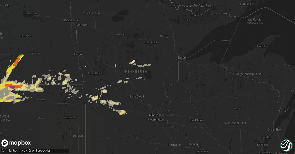
Hail Map in Minnesota on August 9, 2016
Get this storm
August 9 map
$229
one time, instant access
Download today. No call, no setup
Keep the $229
Bought the map and want the full workflow? Apply the entire $229 to a subscription within 7 days. None of it is wasted.
Every map, not just this one
This buys you this map. Subscription and you get every map we run, in the markets you choose from a few cities to whole states to nationwide. Plus real-time alerts the moment a storm fires.
Contact data
Name, contact info, occupancy, even credit band for addresses in the footprint. You go from where it hit to who to call.
Become the source they trust
Unlimited branding weather history reports on demand. You already have the documented answer ready for the property owner, and you are the one who showed up with it.
Property data and RoofTrace estimates
Pull up any address you have got, its value and the exact code rules for that jurisdiction, straight from One Click Code. Then RoofTrace estimates the squares, pitch, and roof value, priced the way you price.
Storm reports in Minnesota
Minnesota
| Date | Description |
|---|---|
| 08/09/20164:35 AM CDT | Strong winds knocked down several trees... One falling on top of a car. Several roads were blocked by trees and large branches. Power outages also occurred. |
| 08/09/20164:15 AM CDT | Numerous large 4 to 8 inch tree branches amd limbs broken down in shelter belts and farmsteads across northern lawrence and stony brook townships. |
| 08/09/20164:10 AM CDT | Tree broken down |
| 08/09/20164:04 AM CDT | Peak wind measured at the tenney rwis... Near highway 75. |
All States Impacted by Hail Map on August 9, 2016
Cities Impacted by Hail Map on August 9, 2016
- McIntosh, SD
- Watauga, SD
- Cleveland, OH
- Eureka, SD
- Hosmer, SD
- Cogswell, ND
- Peerless, MT
- Scobey, MT
- Coffee Creek, MT
- Glen Ullin, ND
- Almont, ND
- Otter, MT
- Herman, MN
- Campbell, MN
- Dawson, ND
- Oakes, ND
- Bowdle, SD
- Stockett, MT
- Great Falls, MT
- Webbers Falls, OK
- Warner, OK
- Muskogee, OK
- Hinsdale, MT
- Malta, MT
- Fort Peck, MT
- Atwater, MN
- Claire City, SD
- New Effington, SD
- Reva, SD
- Ludlow, SD
- Wheatland, WY
- Onamia, MN
- Lake Lillian, MN
- Wakpala, SD
- McLaughlin, SD
- Payson, AZ
- Lewistown, MT
- Denton, MT
- Ekalaka, MT
- Camp Crook, SD
- Capitol, MT
- Hammond, MT
- Crawford, NE
- Harrison, NE
- Kerkhoven, MN
- Cascade, MT
- Hankinson, ND
- Hermosa, SD
- Keystone, SD
- Wolf Creek, MT
- Sun River, MT
- Fallon, MT
- Stanford, MT
- Pierz, MN
- Hillman, MN
- Brainerd, MN
- Long Lake, SD
- Napoleon, ND
- Geraldine, MT
- Winifred, MT
- Ralph, SD
- Lodgepole, SD
- Reeder, ND
- Hettinger, ND
- Rosholt, SD
- Sisseton, SD
- Prescott, AZ
- Murdock, MN
- New London, MN
- Sunburg, MN
- Benson, MN
- Pennock, MN
- Brooten, MN
- Isabel, SD
- Timber Lake, SD
- Leola, SD
- Scranton, ND
- Pine River, MN
- Pequot Lakes, MN
- Westbrook, TX
- Roy, MT
- Custer, SD
- Kintyre, ND
- Lemmon, SD
- Whitewater, MT
- Raynesford, MT
- Geyser, MT
- Lloyd, MT
- Belt, MT
- Hays, MT
- Monarch, MT
- Hilger, MT
- Streeter, ND
- Keldron, SD
- Selfridge, ND
- Morristown, SD
- Whitney, NE
- Buffalo, SD
- Verona, ND
- Eureka, KS
- Wagoner, OK
- Glendive, MT
- Pollock, SD
- Herreid, SD
- Hague, ND
- Ashley, ND
- New Leipzig, ND
- Selby, SD
- Willmar, MN
- Raymond, MN
- Ellendale, ND
- Yucca, AZ
- Carson, ND
- White Sulphur Springs, MT
- Townsend, MT
- New Salem, ND
- Kinsey, MT
- Ismay, MT
- Milnor, ND
- Wyndmere, ND
- Broken Bow, OK
- Bullhead, SD
- Killdeer, ND
- Manning, ND
- Grassy Butte, ND
- Fairfield, ND
- Glasgow, MT
- Zortman, MT
- Java, SD
- Medina, ND
- Marysville, MT
- Lincoln, MT
- Meadow, SD
- Strasburg, ND
- Tappen, ND
- Zeeland, ND
- Linton, ND
- Wishek, ND
- Forsyth, MT
- Bartlett, KS
- Lidgerwood, ND
- Cayuga, ND
- Washburn, ND
- Rapid City, SD
- Mandan, ND
- Mayfield, KS
- Kandiyohi, MN
- Grove City, MN
- Litchfield, MN
- Solen, ND
- Flasher, ND
- Frederick, SD
- Floweree, MT
- Black Eagle, MT
- Graceville, MN
- Elgin, ND
- Forman, ND
- Dodson, MT
- Independence, KS
- Henryetta, OK
- Trail City, SD
- Rutland, ND
- Havana, ND
- Aitkin, MN
- Ironton, MN
- Deerwood, MN
- Merrifield, MN
- Crosby, MN
- Lowry, MN
- Farwell, MN
- Opheim, MT
- Richland, MT
- Saco, MT
- Wibaux, MT
- Roscoe, SD
- Peach Springs, AZ
- Clontarf, MN
- Hancock, MN
- Mentor, OH
- Gwinner, ND
- Lisbon, ND
- Swanville, MN
- Randall, MN
- Little Falls, MN
- Tahlequah, OK
- Park Hill, OK
- Sterling, ND
- Boyes, MT
- Prairie City, SD
- Glencross, SD
- Fullerton, ND
- Bowman, ND
- Mobridge, SD
- Forbes, ND
- Barnard, SD
- Mound City, SD
- Eagle Butte, SD
- Columbia, SD
- Glenham, SD
- Little Eagle, SD
- Westport, SD
- Bison, SD
- Peever, SD
- Spiro, OK
- Cameron, OK
- Veblen, SD
- Terry, MT
- Cyrus, MN
- Morris, MN
- Long Prairie, MN
- Browerville, MN
- Carter, MT
- Kensington, MN
- Alexandria, MN
- Hoffman, MN
- Brandon, MN
- Garfield, MN
- Vian, OK
- Alberta, MN
- Clancy, MT
- Ortonville, MN
- Correll, MN
- Braggs, OK
- Edgeley, ND
- Fort Davis, TX
- Lovington, NM
- Chadron, NE
- Shady Point, OK
- Apache Junction, AZ
- Chetopa, KS
- Beulah, ND
- Dumont, MN
- Hill City, SD
- Oral, SD
- Newcastle, WY
- Smithwick, SD
- Bellville, OH
- Mansfield, OH
- Neihart, MT
- Belgrade, MN
- Starbuck, MN
- Glenwood, MN
- Britton, SD
- Appleton, MN
- Holloway, MN
- Chokio, MN
- Sonoita, AZ
- Mcleod, ND
- Beach, ND
- Coahoma, TX
- Tolstoy, SD
- Beardsley, MN
- Fort Lauderdale, FL
- Highwood, MT
- Center, ND
- Mott, ND
- Cushing, MN
- Augusta, MT
- Columbus, KS
- Pine Bluffs, WY
- North Royalton, OH
- Beachwood, OH
- Strongsville, OH
- Independence, OH
- Fort Yates, ND
- Ipswich, SD
- Hecla, SD
- Sedona, AZ
- Wickliffe, OH
- Willoughby, OH
- Nisswa, MN
- Booneville, AR
- Stirum, ND
- Fayetteville, AR
- Danville, AR
- Choteau, MT
- Kirkland, AZ
- Rhame, ND
- Liberty, KS
- Baker, MT
- Medora, ND
- Chouteau, OK
- Witter, AR
- Perryville, AR
- Ulm, MT
- Greeley, CO
- Kersey, CO
- Lance Creek, WY
- Plainview, AR
- Okemah, OK
- Ola, AR
- Rothsay, MN
- Wolverton, MN
- Stuart, OK
- Mcalester, OK
- Oswego, KS
- Valier, MT
- Browns Valley, MN
- Huntsville, AR
- North Olmsted, OH
- North Ridgeville, OH
- Olmsted Falls, OH
- Columbia Station, OH
- Bagdad, AZ
- Wadena, MN
- Boley, OK
- Lakewood, OH
- Danvers, MN
- Sacred Heart, MN
- Elkins, AR
- Welch, OK
- Edna, KS
- Lake City, SD
- Clinton, MN
- Raleigh, ND
- Hamilton, MT
- Broadus, MT
- Biddle, MT
- Peetz, CO


