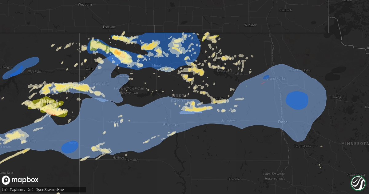
Hail Map in North Dakota on August 7, 2025
Get this storm
August 7 map
$229
one time, instant access
Download today. No call, no setup
Keep the $229
Bought the map and want the full workflow? Apply the entire $229 to a subscription within 7 days. None of it is wasted.
Every map, not just this one
This buys you this map. Subscription and you get every map we run, in the markets you choose from a few cities to whole states to nationwide. Plus real-time alerts the moment a storm fires.
Contact data
Name, contact info, occupancy, even credit band for addresses in the footprint. You go from where it hit to who to call.
Become the source they trust
Unlimited branding weather history reports on demand. You already have the documented answer ready for the property owner, and you are the one who showed up with it.
Property data and RoofTrace estimates
Pull up any address you have got, its value and the exact code rules for that jurisdiction, straight from One Click Code. Then RoofTrace estimates the squares, pitch, and roof value, priced the way you price.
Storm reports in North Dakota
North Dakota
| Date | Description |
|---|---|
| 08/07/20256:20 PM CDT | Hail estimated in size... But significant crop damage occurred in near mature wheat and soybeans. Very little wind. |
| 08/07/20255:16 PM CDT | Quarter size hail falling in rolla at the time of report. |
| 08/07/20259:50 AM CDT | Corrects previous non-tstm wnd gst report from 2 sw moorhead. Mesonet station mn098 moorhead mn dot. |
| 08/07/20254:20 AM CDT | Ndawn mesonet at emerado |
| 08/07/20254:20 AM CDT | Ndawn mesonet at |
| 08/07/20254:15 AM CDT | A tree 4-5 inches in diameter and ~ 10 ft tall was reported down. |
| 08/07/20254:12 AM CDT | Corrects previous non-tstm wnd gst report from 6 wnw grand forks. Asos station kgfk grand forks ap nd. |
| 08/07/20254:12 AM CDT | Grand forks air force base recorded wind gust of 91 mph. |
| 08/07/20254:03 AM CDT | At i-29 near buxton... A semi was reported blown over by the public |
| 08/07/20254:00 AM CDT | Report of a power line down in mayville. Winds estimated at 75 mph. Time estimated via radar. |
| 08/07/20253:56 AM CDT | Report at 10 meters. 58 mph at the surface. |
| 08/07/20253:55 AM CDT | Tree damage around town. Time estimated from radar. |
| 08/07/20253:55 AM CDT | 10 meter wind sensor at the casselton ndawn. |
| 08/07/20253:55 AM CDT | Corrects previous non-tstm wnd gst report from 3 e mayville. Mesonet station 325679 mayville nd ndawn. |
| 08/07/20253:51 AM CDT | Report at 10 meters. 53 mph at the surface. |
| 08/07/20253:50 AM CDT | Tree damage around town. Time estimated from radar. |
| 08/07/20253:50 AM CDT | Corrects previous non-tstm wnd gst report from 2 e logan center. Mesonet station 325332 logan center nd ndawn. |
| 08/07/20253:40 AM CDT | Tree damage around town... Also report of a damaged play shed. Time estimated from radar. |
| 08/07/20253:36 AM CDT | Hope ndawn mesonet recorded 63 mph wind gust near the surface. |
| 08/07/20253:33 AM CDT | Damage to a shop from strong winds was reported. Time estimated via radar. |
| 08/07/20253:09 AM CDT | A local report indicates 74 MPH wind near Valley City |
| 08/07/20252:55 AM CDT | Glenfield nddot site. Time estimated from radar. |
| 08/07/20252:51 AM CDT | Personal weather station. |
| 08/07/20252:50 AM CDT | Ndawn station ypsilanti 2e. Report at 10 meters... 51 mph at the surface. |
| 08/07/20252:45 AM CDT | Nddot site. Time estimated from radar. |
| 08/07/20252:45 AM CDT | Ndawn station courtenay 5w. Report at 10 meters... 63 mph observed at the surface. |
| 08/07/20252:41 AM CDT | Asos station kjms jamestown airport. |
| 08/07/20252:40 AM CDT | Ndawn station courtenay 5w. Report at 10 meters... 43 mph observed at the surface. |
| 08/07/20252:40 AM CDT | Measured wind gust at private weather station. |
| 08/07/20252:38 AM CDT | Multiple power lines down in yard and part of shop roof off. Radar estimated time. |
| 08/07/20252:37 AM CDT | Measured wind gust at private weather station. |
| 08/07/20252:36 AM CDT | Measured wind gust at private weather station. |
| 08/07/20252:35 AM CDT | Arrowwood raws station. Time estimated from radar. |
| 08/07/20252:29 AM CDT | Raws station arrowwood 2. Time estimated by radar. |
| 08/07/20252:20 AM CDT | Measured wind gust at private weather station. |
| 08/07/20252:17 AM CDT | Measured wind gust at private weather station. |
| 08/07/20252:15 AM CDT | Measured wind gust at private weather station. |
| 08/07/20252:11 AM CDT | Nddot station medina i-94 mp. Time estimated by radar. |
| 08/07/20252:10 AM CDT | Measured wind gust at private weather station. |
| 08/07/20251:50 AM CDT | Ndawn station robinson 3nnw. Report at 10 meters... 57 mph reported at the surface. |
| 08/07/20251:40 AM CDT | Mesonet station ts633 long lake nwr. Time estimated by radar. |
| 08/07/20251:40 AM CDT | Nddot station us-83 hazelton ess. Time estimated by radar. |
| 08/07/20251:34 AM CDT | Raws site tatanka prairie nd. Time estimated by radar. |
| 08/07/20251:18 AM CDT | A local report indicates 68 MPH wind near 2 NE Bismarck |
| 08/07/20251:15 AM CDT | Asos station kbis bismarck airport. |
| 08/07/20251:09 AM CDT | Mesonet station cw2059 6 n bismarck. |
| 08/07/202512:55 AM CDT | Estimated wind gust speed. Time estimated from radar. |
| 08/07/202512:34 AM CDT | Ndawn station elgin 10nw. Reported at 10 meters... 51 mph observed at the surface. |
| 08/07/202512:24 AM CDT | Ndawn station manning 4sw. Report at 10 meters... 61 mph observed at the surface. Report was made well behind the line of thunderstorms... With no lightning in the area |
| 08/07/202512:15 AM CDT | Ndawn station manning 4sw. Report at 10 meters... 57 mph observed at the surface. |
| 08/07/202512:11 AM CDT | Ndawn station halliday 4n. Reported at 10 meters... 56 mph observed at the surface. |
| 08/07/202512:10 AM CDT | Ndawn station lefor 10se. Report at 10 meters... 59 mph observed at the surface. |
| 08/06/202511:51 PM CDT | Private weather station observation relayed via emergency manager. |
| 08/06/202511:43 PM CDT | Ndawn station new england 5w. Report at 10 meters... 47 mph observed at the surface. |
| 08/06/202511:39 PM CDT | A local report indicates 63 MPH wind near 3 W Buffalo Springs |
| 08/06/202511:30 PM CDT | A local report indicates 62 MPH wind near 6 S Westhope |
| 08/06/202511:25 PM CDT | Nda |
| 08/06/202511:25 PM CDT | Ndawn station amidon 1ne. Report at 10 meters... 54 mph observed at the surface. |
| 08/06/202511:15 PM CDT | Mesonet station amdn8 sand creek. Time estimated by radar. |
| 08/06/202511:14 PM CDT | Private weather station measured wind gust. |
| 08/06/202511:04 PM CDT | Power poles down. Radar estimated time. |
| 08/06/202510:55 PM CDT | Ndawn station marmarth 2n. Report at 10 meters... 58 mph observed at the surface. |
| 08/06/202510:40 PM CDT | Emergency manager relays image of a camper-trailer flipped on highway 2... At the williams county... Mountrail county line. At 10:20 pm ct... The line of storms was pro |
| 08/06/202510:25 PM CDT | Corrects previous report. Ndawn station 3 n ray. Report at 10 meters... 61 mph observed at the surface. |
| 08/06/202510:25 PM CDT | Ndawn station ray 4n. Reported at 10 meters... 61 mph observed at the surface. |
| 08/06/202510:24 PM CDT | Nddot station grassy butte us-85. Time estimated via radar. |
| 08/06/202510:20 PM CDT | Ndawn station grassy butte 2e. Report at 10 meters... 52 mph at the surface. |
| 08/06/202510:17 PM CDT | Asos station kmot minot airport. |
| 08/06/202510:16 PM CDT | Report relayed through broadcast media of a large tree that fell onto a mobile home and caused 6 large holes in the roof. Believed to have been struck by lightning. Tim |
| 08/06/202510:15 PM CDT | Former nws employee relayed photos of large tree that fell on a camper at roughrider rv park. Camper is totaled. Time estimated from radar. |
| 08/06/20259:55 PM CDT | Awos station k1on 10 s antler. |
| 08/06/20259:31 PM CDT | Awos station k1nn 3 w mohall. |
| 08/06/20259:30 PM CDT | Nddot station blaisedell us-2. |
| 08/06/20259:15 PM CDT | Ndawn station shell lake 2se. Report at 10 meters... 48 mph observed at the surface. |
| 08/06/20259:15 PM CDT | Ndawn station s |
| 08/06/20259:07 PM CDT | Ndawn station palermo 8n. Report at surface. |
| 08/06/20259:03 PM CDT | Local ham radio operator report. |
| 08/06/20258:56 PM CDT | New town dot site. |
| 08/06/20258:41 PM CDT | Stanley 8sw ndawn. |
| 08/06/20258:33 PM CDT | Emergency manager sent video showing rain and hail (up |
| 08/06/20258:33 PM CDT | Emergency manager sent video showing rain and hail |
| 08/06/20258:28 PM CDT | Ndawn station powers lake 6se. Report at 10 meters... 51 mph observed at the surface. |
| 08/06/20258:22 PM CDT | Emergency manager also reports small hail the size of pennies and lots of rain. Visibility is down to around 300ft |
| 08/06/20258:18 PM CDT | Ndawn station dry fork 1se. Report at 10 meters... 55 mph at the surface. |
| 08/06/20258:15 PM CDT | A local report indicates 59 MPH wind near 2 ESE Tioga |
| 08/06/20258:12 PM CDT | Report from mping: quarter |
| 08/06/20257:45 PM CDT | A local report indicates 1.25 inch wind near Columbus |
| 08/06/20257:38 PM CDT | Fire chief r |
| 08/06/20257:38 PM CDT | Fire chief reports 1 inch |
| 08/06/20257:38 PM CDT | Fire chief reports 1 inch hail. Relayed through emergency manager. (b |
| 08/06/20257:36 PM CDT | A local report indicates 1.00 inch wind near 1 N Lignite |
| 08/06/20257:16 PM CDT | A local report indicates 1.25 inch wind near 3 E Columbus |
| 08/06/20257:15 PM CDT | Corrects previous report from 8 nnw corinth. Accompanied by lots of small hail and some quarter size hail. Crop damage. |
| 08/06/20257:15 PM CDT | Accompanied by lots of small hail but some quarters. Crop damage. |
All States Impacted by Hail Map on August 7, 2025
Cities Impacted by Hail Map on August 7, 2025
- Limon, CO
- Lindsay, MT
- Terry, MT
- Minburn, IA
- Adel, IA
- Waukee, IA
- Dallas Center, IA
- Osceola, IA
- Murray, IA
- Weldon, IA
- Humeston, IA
- Glendive, MT
- Bloomfield, MT
- Woodburn, IA
- Van Wert, IA
- De Soto, IA
- Van Meter, IA
- Booneville, IA
- Brockway, MT
- Grand River, IA
- Thayer, IA
- Ellston, IA
- West Des Moines, IA
- Circle, MT
- Leon, IA
- Davis City, IA
- Lineville, IA
- Decatur, IA
- Garden Grove, IA
- Winterset, IA
- Cumming, IA
- Cainsville, MO
- Clive, IA
- Urbandale, IA
- Truro, IA
- Peru, IA
- Allerton, IA
- Saint Charles, IA
- Mercer, MO
- Clio, IA
- Bouton, IA
- Woodward, IA
- Granger, IA
- Princeton, MO
- New Virginia, IA
- Powersville, MO
- Lucerne, MO
- Newtown, MO
- Pollock, MO
- Harris, MO
- Ridgeway, MO
- Higbee, MO
- Milan, MO
- Clark, MO
- Spickard, MO
- Moberly, MO
- Humphreys, MO
- Galt, MO
- Trenton, MO
- Laredo, MO
- Browning, MO
- Linneus, MO
- Purdin, MO
- Chula, MO
- New Boston, MO
- Green Castle, MO
- Winigan, MO
- Brookfield, MO
- Bucklin, MO
- Kirksville, MO
- Ethel, MO
- Waynesville, MO
- Fort Leonard Wood, MO
- Fortuna, ND
- Laclede, MO
- Chillicothe, MO
- Crosby, ND
- Chariton, IA
- Corydon, IA
- Hale, MO
- Owendale, MI
- Pigeon, MI
- Sebewaing, MI
- Gagetown, MI
- Cottonwood, ID
- Elkton, MI
- Buffalo, MT
- Ferdinand, ID
- Nezperce, ID
- Greencreek, ID
- Morganton, GA
- Suches, GA
- Blue Ridge, GA
- Orofino, ID
- Englewood, FL
- Cass City, MI
- Craigmont, ID
- Grass Range, MT
- Redstone, MT
- Ponchatoula, LA
- Robert, LA
- Winnett, MT
- Huntington, VT
- Madisonville, LA
- Covington, LA
- Deford, MI
- Flaxville, MT
- Rolla, ND
- Livingston, LA
- Brusett, MT
- Reserve, MT
- Greycliff, MT
- Antelope, MT
- Owaneco, IL
- Hillman, MI
- Denham Springs, LA
- Stonington, IL
- Taylorville, IL
- Assumption, IL
- Plentywood, MT
- McLeod, MT
- Bird City, KS
- Prairieville, LA
- Pearland, TX
- Reed Point, MT
- Lachine, MI
- Dagmar, MT
- Sand Springs, MT
- Big Timber, MT
- Columbus, MT
- Herron, MI
- Madison, AL
- Moweaqua, IL
- Manvel, TX
- Molt, MT
- Park City, MT
- Westby, MT
- Dalton, GA
- Chatsworth, GA
- Grenora, ND
- Rocklake, ND
- Macon, IL
- Blue Mound, IL
- Rosharon, TX
- Huntsville, AL
- Fresno, TX
- Laurel, MT
- Jordan, MT
- Billings, MT
- Lincoln, MI
- Spruce, MI
- Barton City, MI
- Resaca, GA
- Rapelje, MT
- Ambrose, ND
- Alamo, ND
- Columbus, ND
- Stafford, TX
- Missouri City, TX
- Shepherd, MT
- Sarles, ND
- Hubbard Lake, MI
- Huntley, MT
- Worden, MT
- Ballantine, MT
- Alpena, MI
- Black River, MI
- Posen, MI
- Froid, MT
- Hansboro, ND
- Saint Francis, KS
- Nenzel, NE
- Kilgore, NE
- Hawks, MI
- Fort Peck, MT
- Curran, MI
- Zahl, ND
- McDonald, KS
- Flaxton, ND
- Portal, ND
- Wolf Point, MT
- Nashua, MT
- Williston, ND
- Musselshell, MT
- Lignite, ND
- Wildrose, ND
- Port Allen, LA
- Pompeys Pillar, MT
- Acton, MT
- Hardin, MT
- Custer, MT
- Ingomar, MT
- Hysham, MT
- Richey, MT
- Comins, MI
- Crookston, NE
- Vida, MT
- Atlanta, MI
- Frazer, MT
- Glasgow, MT
- Tioga, ND
- Mcgregor, ND
- Ray, ND
- Noonan, ND
- Bainville, MT
- Epping, ND
- Forsyth, MT
- Powers Lake, ND
- Crow Agency, MT
- Bighorn, MT
- Bowbells, ND
- Sanders, MT
- Colstrip, MT
- Rosebud, MT
- Lambert, MT
- Stanley, ND
- Kenmare, ND
- Tolley, ND
- Sherwood, ND
- Ross, ND
- White Earth, ND
- Hathaway, MT
- Volborg, MT
- Culbertson, MT
- Savage, MT
- Sidney, MT
- Miles City, MT
- Kinsey, MT
- Angela, MT
- Palermo, ND
- Mohall, ND
- Carpio, ND
- Lansford, ND
- Crane, MT
- Fairview, MT
- Donnybrook, ND
- Cartwright, ND
- Maxbass, ND
- Antler, ND
- Plaza, ND
- Berthold, ND
- Des Lacs, ND
- Burlington, ND
- Glenburn, ND
- Minot, ND
- Westhope, ND
- Newburg, ND
- Ismay, MT
- Fallon, MT
- Alexander, ND
- Grassy Butte, ND
- Arnegard, ND
- Watford City, ND
- Minot Afb, ND
- Souris, ND
- Bantry, ND
- Upham, ND
- Deering, ND
- Velva, ND
- Norwich, ND
- Surrey, ND
- Plevna, MT
- Baker, MT
- Ekalaka, MT
- Willard, MT
- Granville, ND
- Voltaire, ND
- Karlsruhe, ND
- Towner, ND
- Kramer, ND
- Bottineau, ND
- New Town, ND
- Killdeer, ND
- Keene, ND
- Mandaree, ND
- Willow City, ND
- Wibaux, MT
- Parshall, ND
- Sentinel Butte, ND
- Beach, ND
- Golva, ND
- Medora, ND
- Belfield, ND
- Fairfield, ND
- Rhame, ND
- Marmarth, ND
- Camp Crook, SD
- Amidon, ND
- Sawyer, ND
- Dunn Center, ND
- Halliday, ND
- Roseglen, ND
- Bowman, ND
- Buffalo, SD
- Atwood, KS
- Ludell, KS
- Rugby, ND
- Herndon, KS
- Oberlin, KS
- Manning, ND
- Dickinson, ND
- South Heart, ND
- New England, ND
- Rolette, ND
- Dunseith, ND
- Belcourt, ND
- Saint John, ND
- Balfour, ND
- Ryder, ND
- Scranton, ND
- Gladstone, ND
- Garrison, ND
- Drake, ND
- Reeder, ND
- Regent, ND
- Richardton, ND
- Lefor, ND
- Taylor, ND
- Dodge, ND
- Hebron, ND
- Beulah, ND
- Zap, ND
- Wolford, ND
- Mylo, ND
- Hazen, ND
- Anamoose, ND
- Coleharbor, ND
- Stanton, ND
- Underwood, ND
- Washburn, ND
- New Salem, ND
- Hettinger, ND
- Mott, ND
- Center, ND
- Glen Ullin, ND
- New Leipzig, ND
- Turtle Lake, ND
- Balta, ND
- Martin, ND
- Esmond, ND
- Bisbee, ND
- Perth, ND
- Elgin, ND
- Carson, ND
- Wilton, ND
- Flasher, ND
- Mandan, ND
- Almont, ND
- Baldwin, ND
- Mercer, ND
- Bismarck, ND
- Regan, ND
- Cando, ND
- Leeds, ND
- York, ND
- Harvey, ND
- Maddock, ND
- Mcclusky, ND
- Raleigh, ND
- Solen, ND
- Saint Anthony, ND
- Menoken, ND
- Sterling, ND
- Shields, ND
- Wing, ND
- Calvin, ND
- Denhoff, ND
- Goodrich, ND
- Minnewaukan, ND
- Churchs Ferry, ND
- Hurdsfield, ND
- Starkweather, ND
- Paradise, MI
- Egeland, ND
- Driscoll, ND
- Tuttle, ND
- Moffit, ND
- Hazelton, ND
- Steele, ND
- Robinson, ND
- Chaseley, ND
- Bowdon, ND
- Dawson, ND
- Tappen, ND
- Penn, ND
- Webster, ND
- Devils Lake, ND
- Pettibone, ND
- Fessenden, ND
- Woodworth, ND
- Medina, ND
- Edmore, ND
- Cathay, ND
- Lawton, ND
- Sykeston, ND
- Carrington, ND
- Pingree, ND
- Sheyenne, ND
- Cleveland, ND
- Jamestown, ND
- Ypsilanti, ND
- Buchanan, ND
- Brocket, ND
- Spiritwood, ND
- Fairdale, ND
- Kensal, ND
- Courtenay, ND
- Glenfield, ND
- Wimbledon, ND
- Cooperstown, ND
- Sutton, ND
- Hannaford, ND
- Sanborn, ND
- Marion, ND
- Dazey, ND
- Litchville, ND
- Rogers, ND
- Valley City, ND
- Hope, ND
- Luverne, ND
- Adams, ND
- Crary, ND
- Kathryn, ND
- Oriska, ND
- Tower City, ND
- Page, ND
- Pillsbury, ND
- Buffalo, ND
- Ayr, ND
- Fingal, ND
- Erie, ND
- Binford, ND
- New Rockford, ND
- Mchenry, ND
- Lakota, ND
- Eckerman, MI
- Hulbert, MI
- Park River, ND
- Mcville, ND
- Finley, ND
- Clifford, ND
- Hatton, ND
- Mayville, ND
- Portland, ND
- Galesburg, ND
- Thompson, ND
- Grand Forks, ND
- Reynolds, ND
- Emerado, ND
- East Grand Forks, MN
- Absaraka, ND
- Amenia, ND
- Buxton, ND
- Arthur, ND
- Hunter, ND
- Blanchard, ND
- Hillsboro, ND
- Wheatland, ND
- Cummings, ND
- Casselton, ND
- Grandin, ND
- Davenport, ND
- Mapleton, ND
- Leonard, ND
- Newberry, MI
- Edinburg, ND
- Niagara, ND
- Petersburg, ND
- Northwood, ND
- Sharon, ND
- Aneta, ND
- Larimore, ND
- Arvilla, ND
- Grand Forks Afb, ND
- Mekinock, ND
- Newaygo, MI
- White Cloud, MI
- Grant, MI
- West Fargo, ND
- Warren, MN
- Gardner, ND
- Caledonia, ND
- Fisher, MN
- Hendrum, MN
- Fargo, ND
- Halstad, MN
- Climax, MN
- Nielsville, MN
- Harwood, ND
- Horace, ND
- Shelly, MN
- Argusville, ND
- Georgetown, MN
- Moorhead, MN
- Perley, MN
- Ada, MN
- Crookston, MN
- Euclid, MN
- Jessie, ND
- Pekin, ND
- Michigan, ND
- Gilby, ND
- Manvel, ND
- Oslo, MN
- Beltrami, MN
- Comstock, MN
- Wolverton, MN
- Dilworth, MN
- Sabin, MN
- Borup, MN
- Glyndon, MN
- Barnesville, MN
- Felton, MN
- Fertile, MN
- Twin Valley, MN
- Rothsay, MN
- Hawley, MN
- Ulen, MN
- Fergus Falls, MN
- Alvarado, MN
- Minto, ND
- Gary, MN
- Mentor, MN
- Lake Park, MN
- Hitterdal, MN
- Thief River Falls, MN
- Saint Hilaire, MN
- Red Lake Falls, MN
- Pelican Rapids, MN
- Elizabeth, MN
- Erhard, MN
- Paris, MI
- Bitely, MI
- Viking, MN
- Erskine, MN
- Alzada, MT
- Naubinway, MI
- Mahnomen, MN
- Waubun, MN
- Bejou, MN
- Winger, MN
- Fosston, MN
- Ogema, MN
- Brooks, MN
- Audubon, MN
- Plummer, MN
- Callaway, MN
- Detroit Lakes, MN
- Oklee, MN
- Trail, MN
- Mcintosh, MN
- Gully, MN
- White Earth, MN
- Naytahwaush, MN
- Vergas, MN
- Lengby, MN
- Rochert, MN
- Frazee, MN
- Ponsford, MN
- Bagley, MN
- Reva, SD
- Big Rapids, MI
- Goodridge, MN
- Gonvick, MN
- Leonard, MN
- Park Rapids, MN
- Shevlin, MN
- Clearbrook, MN
- Prairie City, SD
- Weston, WY
- Lemmon, SD
- Meadow, SD
- Henning, MN
- Alexandria, MN
- Lowry, MN
- Presque Isle, MI
- Rogers City, MI


