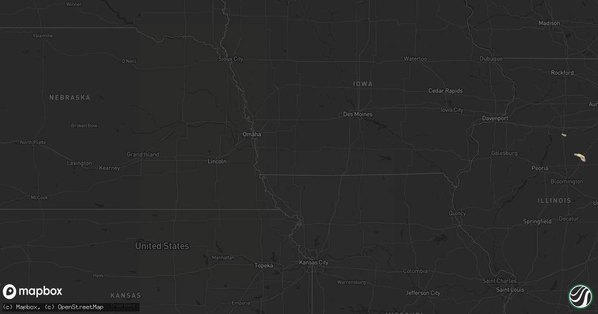
Hail Map in Indiana on August 7, 2013
Get this storm
August 7 map
$229
one time, instant access
Download today. No call, no setup
Keep the $229
Bought the map and want the full workflow? Apply the entire $229 to a subscription within 7 days. None of it is wasted.
Every map, not just this one
This buys you this map. Subscription and you get every map we run, in the markets you choose from a few cities to whole states to nationwide. Plus real-time alerts the moment a storm fires.
Contact data
Name, contact info, occupancy, even credit band for addresses in the footprint. You go from where it hit to who to call.
Become the source they trust
Unlimited branding weather history reports on demand. You already have the documented answer ready for the property owner, and you are the one who showed up with it.
Property data and RoofTrace estimates
Pull up any address you have got, its value and the exact code rules for that jurisdiction, straight from One Click Code. Then RoofTrace estimates the squares, pitch, and roof value, priced the way you price.
Storm reports in Indiana
Indiana
| Date | Description |
|---|---|
| 08/07/20135:15 PM CDT | Report of trees and branches down on a couple utility lines on sr 109 near county line. |
| 08/07/20133:58 PM CDT | A local report indicates 60 MPH wind near BREMEN |
| 08/07/20131:27 PM CDT | A local report indicates 1.25 inch wind near 2 SE GEORGETOWN |
| 08/07/20131:15 PM CDT | Wind gust estimated at 60 mph and 1 inch hail on cleveland rd. |
| 08/07/20131:15 PM CDT | Wind gust estimated at 60 mph and 1 inch hail on cleveland rd. |
All States Impacted by Hail Map on August 7, 2013
Cities Impacted by Hail Map on August 7, 2013
- Higgins, TX
- Canadian, TX
- Garrett, WY
- Bosler, WY
- Hugoton, KS
- Vinson, OK
- Custer, SD
- Belle Fourche, SD
- Homer City, PA
- Blairsville, PA
- Wallace, KS
- Lame Deer, MT
- Pine Ridge, SD
- Berryville, AR
- Weston, WY
- Lead, SD
- Covert, MI
- South Haven, MI
- Otter, MT
- Chicora, PA
- Karns City, PA
- West Sunbury, PA
- Allenport, PA
- Elco, PA
- Newell, PA
- Coal Center, PA
- Roscoe, PA
- California, PA
- Stockdale, PA
- Fayette City, PA
- Coloma, MI
- Hulett, WY
- Moorcroft, WY
- Granger, IN
- Galien, MI
- New Carlisle, IN
- Niles, MI
- La Porte, IN
- Rolling Prairie, IN
- Mishawaka, IN
- Notre Dame, IN
- South Bend, IN
- Buchanan, MI
- New Buffalo, MI
- Three Oaks, MI
- Oak Grove, AR
- Boise City, OK
- Pueblo, CO
- Kress, TX
- Ashland, MT
- Lawton, MI
- Decatur, MI
- Paw Paw, MI
- Hartford, MI
- Lawrence, MI
- Gillette, WY
- Clayton, NM
- Mountain View, AR
- Melbourne, AR
- Republic, OH
- Newcastle, WY
- Okarche, OK
- Trinidad, CO
- Sonora, TX
- Kirbyville, MO
- Omaha, AR
- Forsyth, MT
- Upton, WY
- Beaver, OK
- Balko, OK
- Weatherford, OK
- McConnellsburg, PA
- Fort Loudon, PA
- Worthington, PA
- Cowansville, PA
- East Brady, PA
- Templeton, PA
- Kittanning, PA
- Adrian, PA
- Eldorado, OK
- Eureka Springs, AR
- Boley, OK
- Castle, OK
- Paden, OK
- Colon, MI
- Sherwood, MI
- Leonidas, MI
- Indiana, PA
- Lake City, KS
- Grovertown, IN
- Plymouth, IN
- Gould, OK
- Plainwell, MI
- Kalamazoo, MI
- Burnt Cabins, PA
- Olney Springs, CO
- Falkville, AL
- Vega, TX
- Canute, OK
- Rosston, OK
- Town Creek, AL
- Mount Hope, AL
- Russellville, AL
- Cascade, MT
- Clarksburg, PA
- Aultman, PA
- Shelocta, PA
- Saltsburg, PA
- Clune, PA
- McIntyre, PA
- Kennebec, SD
- Presho, SD
- Cadiz, OH
- Adena, OH
- Rogers, AR
- Richfield, KS
- Rolla, KS
- Branson, CO
- Granite, OK
- Dacoma, OK
- Petrolia, PA
- Hillsboro, AL
- Tuscumbia, AL
- Athens, AL
- Elkmont, AL
- Butler, PA
- Kaycee, WY
- Moulton, AL
- Snyder, TX
- Fowler, CO
- Pontiac, IL
- Mertzon, TX
- Pell City, AL
- Lincoln, AL
- Riverside, AL
- Musselshell, MT
- Fairburn, SD
- Hermosa, SD
- Brooksville, FL
- Massena, IA
- Duke, OK
- Mangum, OK
- Bighorn, MT
- Slippery Rock, PA
- Boyers, PA
- Medford, OK
- Bluff City, KS
- Michigan City, IN
- Bangor, MI
- Boone, CO
- Vancourt, TX
- Hannibal, OH
- New Martinsville, WV
- Sardis, OH
- Clarington, OH
- Devils Tower, WY
- Boncarbo, CO
- Aguilar, CO
- Weston, CO
- Lampe, MO
- Shell Knob, MO
- Garfield, AR
- Keyes, OK
- Elkhart, KS
- Goodwell, OK
- Sedan, NM
- Ozona, TX
- Hooker, OK
- Booker, TX
- Lipscomb, TX
- Follett, TX
- Bremen, IN
- Rozet, WY
- Buffalo, OK
- Laverne, OK
- Starkville, MS
- Roosevelt, OK
- Marshall, AR
- Onia, AR
- Timbo, AR
- Turpin, OK
- Gregory, SD
- Miami, TX
- Plymouth, OH
- Willard, OH
- Tyrone, OK
- Scotts, MI
- Climax, MI
- Coffeeville, AL
- Thomasville, AL
- Cumberland Furnace, TN
- Cunningham, TN
- Old Town, FL
- Perryton, TX
- Jackson, AL
- San Angelo, TX
- Medina, OH
- Litchfield, OH
- Model, CO
- Arnett, OK
- Batesville, AR
- Magness, AR
- Newark, AR
- Campo, CO
- Walsh, CO
- Seward, PA
- Vintondale, PA
- North Lawrence, OH
- Dalton, OH
- Orrville, OH
- Deadwood, SD
- Vicksburg, MI
- Luther, OK
- Tulia, TX
- Smithville, OH
- Wooster, OH
- Abernathy, TX
- Shallowater, TX
- Ridgedale, MO
- Green Forest, AR
- Harrison, AR
- Hollister, MO
- Fayette, OH
- Hudson, MI
- Waldron, MI
- Morenci, MI
- Wauseon, OH
- Adrian, TX
- Dalhart, TX
- Watervliet, MI
- Benton Harbor, MI
- Goshen, IN
- Lakeville, IN
- Wakarusa, IN
- Gilbertown, AL
- Silas, AL
- Atwater, OH
- Deerfield, OH
- Rootstown, OH
- Rocky, OK
- Shattuck, OK
- Danville, KS
- Harper, KS
- Ralls, TX
- Lorenzo, TX
- Floydada, TX
- Waynoka, OK
- Hamlet, IN
- Ordway, CO
- Sugar City, CO
- Choctaw, OK
- Jones, OK
- Clyde, OH
- Fremont, OH
- Otsego, MI
- Cimarron, NM
- Locust Grove, AR
- Cheyenne, OK
- Big Cabin, OK
- Chelsea, OK
- Harrisville, PA
- Hilliards, PA
- Valparaiso, IN
- Campbell, AL
- Pittsford, MI
- Hillsdale, MI
- Osseo, MI
- Elk City, OK
- Butler, OK
- Hammon, OK
- Desha, AR
- Okemah, OK
- Ardmore, TN
- White Sulphur Springs, MT
- Great Falls, MT
- Dawson, PA
- Perryopolis, PA
- Chamberlain, SD
- Shubuta, MS
- Quitman, MS
- New Philadelphia, OH
- Dover, OH
- Glenrock, WY
- Forgan, OK
- Eldorado, TX
- Walkerton, IN
- Dawn, MO
- Hereford, TX
- Ohatchee, AL
- Shreve, OH
- Union Mills, IN
- Graymont, IL
- Dumas, TX
- Massillon, OH
- Spruce Pine, AL
- Guymon, OK
- Osceola, IN
- Elkhart, IN
- Lone Wolf, OK
- Leedey, OK
- Avonmore, PA
- Johnstown, PA
- Armagh, PA
- Lowell, AR
- Rural Valley, PA
- Concord, AR
- Drasco, AR
- Mercer, PA
- Grove City, PA
- Geraldine, AL
- Albertville, AL
- Girard, TX
- Mill Creek, IN
- Kingfisher, OK
- Caldwell, KS
- Union City, OK
- Ochelata, OK
- Dover, AR
- Beverly Shores, IN
- Noel, MO
- Bella Vista, AR
- Mount Pleasant, AR
- Fenelton, PA
- Dayton, PA
- Yatesboro, PA
- Quanah, TX
- Gravette, AR
- Canton, OH
- Reliance, SD
- Green Springs, OH
- Bellevue, OH
- Rockmart, GA
- Gotebo, OK
- Hobart, OK
- Fifty Six, AR
- Lexington, TN
- Darden, TN
- Lakewood, OH
- Cleveland, OH
- Springer, NM
- Sayre, OK
- Carney, OK
- Chandler, OK
- Bentleyville, PA
- Monongahela, PA
- Eighty Four, PA
- Gulfport, MS
- Watonga, OK
- Seville, OH
- Chippewa Lake, OH
- Olustee, OK
- Courtland, MS
- Water Valley, MS
- Birney, MT
- Fulton, MS
- Anthony, KS
- Oneonta, AL
- Hardesty, OK
- East Canton, OH
- Fostoria, OH
- New Riegel, OH
- Tiffin, OH
- Chillicothe, TX
- Cherokee, OK
- Holladay, TN
- Nappanee, IN
- Hanna, IN
- Argos, IN
- Geary, OK
- Corn, OK
- Scotts Hill, TN
- Decaturville, TN
- Springdale, AR
- Grenville, NM
- Dundee, OH
- Fredericksburg, OH
- Apple Creek, OH
- Alabaster, AL
- Calera, AL
- Waynesboro, MS
- Pulaski, TN
- Pettigrew, AR
- Westville, IN
- Wanatah, IN
- Dill City, OK
- Sentinel, OK
- Edgemont, SD
- Greenwich, OH
- New London, OH
- Greenfield, OK
- Fowler, KS
- Channing, TX
- Swanton, OH
- Vanleer, TN
- Parkhill, PA
- Dilltown, PA
- Spring Church, PA
- Coral, PA
- Apollo, PA
- New Florence, PA
- Mineral Point, PA
- South Fork, PA
- Wilmore, KS
- North Liberty, IN
- South Haven, KS
- Buffalo, WY
- Attica, OH
- Monroeville, OH
- Fayetteville, AR
- Hindsville, AR
- Seligman, MO
- Oglesby, IL
- Tonica, IL
- Crossville, AL
- Adair, OK
- Cordell, OK
- Collins, OH
- Cassville, MO
- Taloga, OK
- La Junta, CO
- Sweetwater, OK
- Danville, AL
- Wellston, OK
- Cullman, AL
- Sundance, WY
- Bloomville, OH
- Rome, GA
- Marshallville, OH
- Sterling, OH
- Creston, OH
- Rittman, OH
- Spur, TX
- Wakita, OK
- Manchester, OK
- Vici, OK
- Lenapah, OK
- Paden City, WV
- Proctor, WV
- East Sparta, OH
- Waynesburg, OH
- Crowell, TX
- Parrish, FL
- Fannettsburg, PA
- Fort Littleton, PA
- Cedartown, GA
- Mendon, MI
- Leslie, AR
- Sawyer, MI
- Meridian, MS
- Prospect, TN
- Newell, SD


