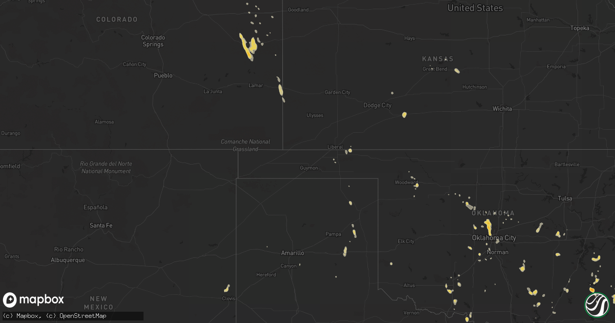
Hail Map on August 7, 2012
Get this storm
August 7 map
$229
one time, instant access
Download today. No call, no setup
Keep the $229
Bought the map and want the full workflow? Apply the entire $229 to a subscription within 7 days. None of it is wasted.
Every map, not just this one
This buys you this map. Subscription and you get every map we run, in the markets you choose from a few cities to whole states to nationwide. Plus real-time alerts the moment a storm fires.
Contact data
Name, contact info, occupancy, even credit band for addresses in the footprint. You go from where it hit to who to call.
Become the source they trust
Unlimited branding weather history reports on demand. You already have the documented answer ready for the property owner, and you are the one who showed up with it.
Property data and RoofTrace estimates
Pull up any address you have got, its value and the exact code rules for that jurisdiction, straight from One Click Code. Then RoofTrace estimates the squares, pitch, and roof value, priced the way you price.
States Impacted by Hail Map on August 7, 2012
Storm reports
Nebraska
| Date | Description |
|---|---|
| 08/07/20126:38 PM CDT | Quarter size hail slowly got smaller. Ground was white. 0.75 of an inch of rainfall reported. |
| 08/07/20126:26 PM CDT | Corrected time. |
| 08/07/20126:15 PM CDT | Hail up the size of ping pong was reported. |
| 08/07/20126:05 PM CDT | Estimated 50 to 60 mph wind gusts as thunderstorm passed through imperial. |
| 08/07/20126:01 PM CDT | Golf ball sized shattered windshield 3 nw of wolbach. |
| 08/07/20126:00 PM CDT | Hail up to the size of quarters started near 6 pm and fell for 10 to 15 minutes. |
| 08/07/20126:00 PM CDT | Power pole broken in half in imperial. Power outage continues for the city of imperial. Power was also knocked out at the automated surface observing station at the imp |
| 08/07/20125:56 PM CDT | A local report indicates 1.00 inch wind near ST. EDWARD |
| 08/07/20125:47 PM CDT | Quarter size hail currently falling. Ground is completely covered and visibility is poor due to hail. |
| 08/07/20125:41 PM CDT | A local report indicates 1.75 inch wind near 1 E WOLBACH |
| 08/07/20125:20 PM CDT | Hail up to the size of quarters started falling around 520 pm...and was still falling. |
| 08/06/20129:30 PM CDT | 4 power poles blown down. Crops flatten. Delayed report |
| 08/06/20127:52 PM CDT | Winds estimated up to 60 mph. |
| 08/06/20127:48 PM CDT | Tree limbs breaking. No size indicated. |
| 08/06/20127:24 PM CDT | Pea size hail also. |
| 08/06/20127:00 PM CDT | Hail up to the size of golf balls started near 7 pm and was still ongoing. |
| 08/06/20127:00 PM CDT | Mostly small hail reported...but there were a few quarter size hail stones. |
Kansas
| Date | Description |
|---|---|
| 08/07/20126:39 PM CDT | Law enforcement reports power poles snapped in half approximately 6 miles east and 1 mile north of great bend. Time is estimated based on radar. |
| 08/07/20123:43 PM CDT | Minor roof damage was reported at the methodist church in mullinville. Several windows were also cracked or broken. |
Iowa
| Date | Description |
|---|---|
| 08/07/20123:15 PM CDT | Resident reports siding torn off of house and an outbuilding...windows blown out of the house...and power is out. Relayed by county dispatch center. Delayed report. Tim |
| 08/06/20129:30 PM CDT | 4 power poles blown down. Crops flatten. Delayed report |
| 08/06/20129:18 PM CDT | Near the mormon bridge. |
Colorado
| Date | Description |
|---|---|
| 08/06/20128:32 PM CDT | A local report indicates 64 MPH wind near 4 S BURLINGTON |
| 08/06/20127:45 PM CDT | Hail to near quarter size...60 mph winds and very heavy rain estimated by cdot workers on highway 89 near holly. |
Wisconsin
| Date | Description |
|---|---|
| 08/07/20124:03 PM CDT | Measured hail 1 and 1/4 to 1 and 1/2 inch in diameter. Minor damage to trees...outdoor equipment...and vehicles. Time estimated. |
South Dakota
| Date | Description |
|---|---|
| 08/07/20124:35 PM CDT | A local report indicates 1.00 inch wind near 5 E SCENIC |
| 08/07/20124:15 PM CDT | A local report indicates 1.50 inch wind near 9 SE SCENIC |
| 08/07/20123:15 AM CDT | A local report indicates 58 MPH wind near 2 NNW HURON |
Arizona
| Date | Description |
|---|---|
| 08/06/201211:45 PM CDT | Extensive roof damage to elementary school |
| 08/06/201211:41 PM CDT | A local report indicates 62 MPH wind near 1 ESE FORT HUACHUCA |
Arkansas
| Date | Description |
|---|---|
| 08/07/20124:50 PM CDT | Tree down near highway 282 |
| 08/07/20123:30 PM CDT | Trees reported down. |
| 08/07/20123:30 PM CDT | A local report indicates 1.00 inch wind near COVE |
Oklahoma
| Date | Description |
|---|---|
| 08/07/20126:05 PM CDT | A local report indicates 58 MPH wind near 1 SSW BEAVER |
| 08/07/20125:50 PM CDT | Multiple power poles downed near 164th and macarthur blvd. Some poles fell into homes. |
| 08/07/20125:30 PM CDT | Several trees down... Wind estimated 60 to 70 mph. |
| 08/07/20125:05 PM CDT | Trees down on road |
| 08/07/20124:55 PM CDT | A local report indicates 65 MPH wind near 6 W MINCO |
| 08/07/20123:40 PM CDT | A local report indicates 60 MPH wind near ASHER |
| 08/07/20122:55 PM CDT | At grocery store in battiest |
| 08/07/20121:30 PM CDT | Marble to golf ball size hail reported. |
| 08/07/20121:30 PM CDT | Numerous large tree limbs blown down in and near stanley. |
| 08/06/20127:01 PM CDT | Nw 112th/nw cache rd 5-6 pwr poles down. |
Texas
| Date | Description |
|---|---|
| 08/07/20126:55 PM CDT | A local report indicates 1.00 inch wind near 5 E EDOM |
| 08/07/20126:52 PM CDT | Trees down on fm 2863 |
| 08/07/20126:30 PM CDT | Damage to solar panels with unknown wind speeds |
| 08/07/20125:45 PM CDT | Tree blown down and other large branches blown down near kbtx tv in college station. Time approximate. |
| 08/07/20124:55 PM CDT | 62-mph wind gust at clark field |
| 08/06/20129:05 PM CDT | Estimated 60 mph winds at alanreed travel center at mile marker 135 on i-40 |
| 08/06/20127:51 PM CDT | Damage reported to a center pivot system |
| 08/06/20127:38 PM CDT | With heavy rain and limited visibility |
| 08/06/20127:34 PM CDT | Telephone lines blown down at intersection of highway 342 and wintergreen. |
| 08/06/20127:19 PM CDT | Quarter hail at i45 and wintergreen |
| 08/06/20127:02 PM CDT | Quarter hail near chandler. |
Louisiana
| Date | Description |
|---|---|
| 08/07/20125:23 PM CDT | Tree down on paul jordan road |
| 08/07/20125:21 PM CDT | Several trees down in natchitoches |
Georgia
| Date | Description |
|---|---|
| 08/07/20124:21 PM CDT | A tree fell into the right lane of interstate 95 southbound near mile marker 97. |
| 08/07/20124:15 PM CDT | Trained spotter reported quarter size hail in richmond hill near the intersection of highways 17 and 144. |
| 08/07/20123:47 PM CDT | Liberty county dispatch reported several trees and power lines down. One tree was on a house. |
| 08/07/20123:24 PM CDT | Thunderstorm winds blew down power lines near the intersection of sam green and herbert holton roads. Time of event was estimated from radar data. |
| 08/07/20122:40 PM CDT | Large tree down on hwy 82 and co rd 212 |
Ohio
| Date | Description |
|---|---|
| 08/06/201211:45 PM CDT | Limbs and trees. |
Cities Impacted by Hail Map on August 7, 2012
- Wolbach, NE
- Scotia, NE
- Elba, NE
- Saint Paul, NE
- Greeley, NE
- Earling, IA
- Kinta, OK
- Snow, OK
- Clayton, OK
- Nashoba, OK
- Hennessey, OK
- Cedar Creek, NE
- Springfield, NE
- Plattsmouth, NE
- Papillion, NE
- Louisville, NE
- Doland, SD
- Truro, IA
- Okarche, OK
- Midway, GA
- Fleming, GA
- Katy, TX
- Eckley, CO
- Yuma, CO
- Clarksville, TX
- Deport, TX
- Bogata, TX
- Bagwell, TX
- Detroit, TX
- Blossom, TX
- Mullinville, KS
- Greensburg, KS
- Lake Preston, SD
- Creston, NE
- Madison, NE
- Platte Center, NE
- Humphrey, NE
- Columbus, NE
- Agra, KS
- Lufkin, TX
- Bellwood, NE
- Clovis, NM
- Lancaster, TX
- Dallas, TX
- Wilmer, TX
- Hutchins, TX
- North Bend, NE
- Scribner, NE
- Elgin, OK
- Guthrie, OK
- Manning, IA
- Geraldine, AL
- Dawson, AL
- Batesland, SD
- Haxtun, CO
- Okmulgee, OK
- Henryetta, OK
- Dunlap, IA
- Panama, IA
- Westphalia, IA
- Harlan, IA
- Woodbine, IA
- Defiance, IA
- Ryan, OK
- Waurika, OK
- Blair, NE
- Kiowa, OK
- Manilla, IA
- Emerson, IA
- Benkelman, NE
- Venango, NE
- Imperial, NE
- Enders, NE
- Champion, NE
- Exira, IA
- Hamlin, IA
- Audubon, IA
- Peru, IA
- Hayes Center, NE
- Oklahoma City, OK
- Oviedo, FL
- Winter Springs, FL
- Great Bend, KS
- Nacogdoches, TX
- Akron, CO
- Bastrop, LA
- Campbell, NE
- Bladen, NE
- Farragut, IA
- Riverton, IA
- Mobeetie, TX
- West Bend, WI
- Many, LA
- Woodward, IA
- West Point, NE
- Walters, OK
- Stratton, CO
- Kit Carson, CO
- Campbellsport, WI
- Kewaskum, WI
- Stratford, OK
- Byars, OK
- Ada, OK
- Asher, OK
- Bison, SD
- Lodgepole, SD
- Caney, OK
- Irwin, IA
- Kimballton, IA
- Kirkman, IA
- Crook, CO
- Lorimor, IA
- Macksburg, IA
- Robeline, LA
- Natchitoches, LA
- Coushatta, LA
- Saline, LA
- Goldonna, LA
- Campti, LA
- Simms, TX
- New Boston, TX
- Baskin, LA
- Winnsboro, LA
- Smithville, OK
- Milburn, OK
- Tishomingo, OK
- Maryville, MO
- Mooreland, OK
- Carson, IA
- Macedonia, IA
- Prairie City, IA
- Colfax, IA
- Perryton, TX
- Brownsboro, TX
- Chandler, TX
- Ben Wheeler, TX
- Wiergate, TX
- Burkeville, TX
- Anacoco, LA
- Hemphill, TX
- Leigh, NE
- Northport, AL
- Willow, OK
- Lamar, OK
- Holdenville, OK
- Dustin, OK
- Piedmont, OK
- Edmond, OK
- Cashion, OK
- Ovid, CO
- Massena, IA
- Tupelo, OK
- Atlantic, IA
- Anita, IA
- Wiota, IA
- Rayville, LA
- Dodd City, TX
- Tekamah, NE
- Lyons, KS
- Chase, KS
- Watson, OK
- Cove, AR
- Konawa, OK
- Fremont, NE
- Nickerson, NE
- Arlington, NE
- Scenic, SD
- Genoa, NE
- Saint Edward, NE
- Lindsay, NE
- Dodge, NE
- Shenandoah, IA
- Coin, IA
- Northboro, IA
- Hamburg, IA
- Timpson, TX
- Tuttle, OK
- Amber, OK
- Byers, TX
- Eads, CO
- Seagoville, TX
- Forney, TX
- Mesquite, TX
- Cheyenne Wells, CO
- Hartford, SD
- Humboldt, SD
- Clarendon, TX
- Mclean, TX
- Bloomingdale, GA
- Adel, IA
- Lebanon, KS
- Holly, CO
- Isabella, OK
- Holyoke, CO
- Angora, NE
- Paden, OK
- Bridgewater, IA
- Kellerton, IA
- Faxon, OK
- Lawton, OK
- Broken Bow, OK
- Brayton, IA
- Mound City, MO
- Maitland, MO
- Seymour, TX
- Omaha, NE
- Fort Calhoun, NE
- Crescent, IA
- Syracuse, KS
- Clark, SD
- Atlanta, TX
- De Kalb, TX
- Smith Center, KS
- Blanchard, OK
- Parks, NE
- Palmer, NE
- Belgrade, NE
- Avoca, IA
- Muse, OK
- Whitesboro, OK
- Talihina, OK
- Carthage, TX
- Wolsey, SD
- Inavale, NE
- Collins, GA
- Cobbtown, GA
- Claxton, GA
- Roff, OK
- Bellevue, NE
- Terrell, TX
- Craig, NE
- Lyons, NE
- Decatur, NE
- Dubach, LA
- Hodgen, OK
- Collinsville, TX
- Watertown, WI
- Ixonia, WI
- Ellabell, GA
- Fullerton, NE
- Monroe, NE
- Waskom, TX
- Missouri Valley, IA
- Red Oak, IA
- Okemah, OK
- Fyffe, AL
- Claflin, KS
- Lenox, IA
- Wilburton, OK
- Dover, OK
- Richmond Hill, GA
- Cache, OK
- Herman, NE
- Boaz, AL
- Garrison, TX
- Wellston, OK
- Forgan, OK
- Pembroke, GA
- Weleetka, OK
- Caddo, OK
- Offutt Afb, NE
- Henrietta, TX
- De Smet, SD
- Stringtown, OK
- Riverton, NE
- Wauneta, NE
- Blockton, IA
- Redding, IA
- Red Oak, OK
- Henderson, IA
- Fairview, OK
- Tuskahoma, OK
- Fontanelle, IA
- Lumber City, GA
- Fletcher, OK
- Wessington, SD
- Saint Lawrence, SD
- Burlington, CO
- Mondamin, IA
- Logan, IA
- Rural Retreat, VA
- De Berry, TX
- Bethany, LA
- Keithville, LA
- Greenwood, LA
- Nogales, AZ
- Tumacacori, AZ
- Randolph, IA
- Mayville, WI
- Theresa, WI
- Minco, OK
- Neola, IA
- Persia, IA
- Crescent, OK
- Quinton, OK
- Sharon, OK
- Hatfield, AR
- Depew, OK
- Stroud, OK
- Holstein, NE
- Murdock, NE
- Marlow, OK
- Arcadia, OK
- Houston, TX
- Modale, IA
- Hooper, NE
- Brooksville, FL
- Bennington, OK
- Albertville, AL
- Meridian, OK
- Chandler, OK
- Stonewall, OK
- Clarkson, NE
- Slinger, WI
- Moorhead, IA
- Huron, SD
- Elk Horn, IA
- Otis, CO
- West Monroe, LA
- Woodward, OK
- Geneva, FL
- Harlem, GA
- Skidmore, MO
- Vona, CO
- Gretna, VA
- Moundville, AL
- Mutual, OK
- Oakland, NE
- Amity, AR
- Custer, SD
- Belleview, FL
- Ocala, FL
- Hitchcock, SD
- Esbon, KS
- Council Bluffs, IA
- McClelland, IA
- Bouton, IA
- Marthaville, LA
- Belmont, LA
- Tyler, TX
- Fayette, AL
- Morse Bluff, NE
- Vienna, SD
- Turpin, OK
- El Reno, OK
- Mount Hope, AL
- Walnut, IA
- Rodessa, LA
- Ida, LA
- Doddridge, AR
- Grovetown, GA
- Mangham, LA
- Ellston, IA
- Mustang, OK
- Lockesburg, AR
- Chickasha, OK
- Pittsburg, OK
- Atoka, OK
- Rockwall, TX
- Prescott, IA
- Carthage, SD
- Kingfisher, OK
- South Pittsburg, TN
- Templeton, IA
- Bivins, TX
- Bloomburg, TX
- Crossville, AL
- Vermillion, KS
- Frankfort, KS
- Uvalda, GA
- Howells, NE
- Magnolia, IA
- Oshkosh, NE
- Cypress, TX
- Mill Creek, OK
- Cavour, SD
- Iroquois, SD
- Yale, SD
- Kingston, OK
- Diagonal, IA
- Tuscaloosa, AL
- Seibert, CO
- Bethel, OK
- Pearson, GA
- Bay City, MI
- Ivanhoe, TX
- Telephone, TX
- Merriman, NE
- Mankato, KS
- Canadian, TX
- Newcastle, OK
- Delhi, LA
- Lyons, GA
- Oxford, FL
- Hinesville, GA
- Spearville, KS
- Fort Pierce, FL
- Windom, TX
- Cawker City, KS
- Dearing, GA