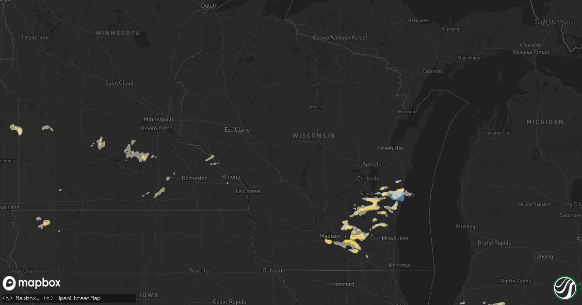
Hail Map in Wisconsin on August 6, 2021
Get this storm
August 6 map
$229
one time, instant access
Download today. No call, no setup
Keep the $229
Bought the map and want the full workflow? Apply the entire $229 to a subscription within 7 days. None of it is wasted.
Every map, not just this one
This buys you this map. Subscription and you get every map we run, in the markets you choose from a few cities to whole states to nationwide. Plus real-time alerts the moment a storm fires.
Contact data
Name, contact info, occupancy, even credit band for addresses in the footprint. You go from where it hit to who to call.
Become the source they trust
Unlimited branding weather history reports on demand. You already have the documented answer ready for the property owner, and you are the one who showed up with it.
Property data and RoofTrace estimates
Pull up any address you have got, its value and the exact code rules for that jurisdiction, straight from One Click Code. Then RoofTrace estimates the squares, pitch, and roof value, priced the way you price.
Storm reports in Wisconsin
Wisconsin
| Date | Description |
|---|---|
| 08/06/20216:32 PM CDT | 1 to 1.5 hail. Picture via social media. |
| 08/06/20216:15 PM CDT | 1-1.5 inch hail. Reported via social media. Time estimated from radar. |
| 08/06/20214:58 PM CDT | 3 inch tree limbs reported broken. Received via mping. |
| 08/06/20214:45 PM CDT | Relayed report of tree damage in plymouth. Time estimated. |
| 08/06/20214:28 PM CDT | Measured at the asos at sheboygan county memorial airport. |
| 08/06/20214:28 PM CDT | Asos station ksbm sheboygan-airport. |
| 08/06/20214:45 AM CDT | At 945 PM CDT, a severe thunderstorm was located near Oregon, moving southeast at 10 mph. HAZARD...Quarter size hail. SOURCE...Radar indicated. IMPACT...Damage to vehicles is expected. Locations impacted include... Madison, Fitchburg, Stoughton, Oregon, McFarland, Monona, Edgerton, Brooklyn and Albion. |
| 08/06/20213:14 AM CDT | At 813 PM CDT, a severe thunderstorm was located near Whitewater, moving east at 10 mph. HAZARD...Quarter size hail. SOURCE...Radar indicated. IMPACT...Damage to vehicles is expected. Locations impacted include... Whitewater, Richmond and Lima Center. |
| 08/06/20212:38 AM CDT | At 737 PM CDT, a severe thunderstorm was located over Fort Atkinson, and is nearly stationary. HAZARD...60 mph wind gusts and quarter size hail. SOURCE...Radar indicated. IMPACT...Hail damage to vehicles is expected. Expect wind damage to roofs, siding, and trees. Locations impacted include... Whitewater, Fort Atkinson, Jefferson, Palmyra and Hebron. |
| 08/06/20211:22 AM CDT | At 622 PM CDT, a severe thunderstorm was located over Lake Mills, moving east at 15 mph. HAZARD...60 mph wind gusts and quarter size hail. SOURCE...Radar indicated. IMPACT...Hail damage to vehicles is expected. Expect wind damage to roofs, siding, and trees. Locations impacted include... Jefferson, Lake Mills, Johnson Creek and Milford. |
| 08/06/202112:06 AM CDT | At 506 PM CDT, a severe thunderstorm was located over Belgium, or 8 miles north of Port Washington, moving southeast at 15 mph. HAZARD...60 mph wind gusts and quarter size hail. SOURCE...Radar indicated. IMPACT...Hail damage to vehicles is expected. Expect wind damage to roofs, siding, and trees. Locations impacted include... Port Washington, Belgium, Fredonia, Cedar Grove, Random Lake and Harrington Beach St Park. |
| 08/05/202111:58 PM CDT | At 457 PM CDT, a severe thunderstorm was located near Waterloo, moving east at 20 mph. HAZARD...60 mph wind gusts and quarter size hail. SOURCE...Radar indicated. IMPACT...Hail damage to vehicles is expected. Expect wind damage to roofs, siding, and trees. Locations impacted include... Watertown, Waterloo, Reeseville, Richwood, Lowell and Hubbleton. |
| 08/05/202111:38 PM CDT | At 438 PM CDT, a severe thunderstorm was located near Sheboygan Falls, moving east at 15 mph. HAZARD...60 mph wind gusts and quarter size hail. SOURCE...Radar indicated. IMPACT...Hail damage to vehicles is expected. Expect wind damage to roofs, siding, and trees. Locations impacted include... Sheboygan, Plymouth, Sheboygan Falls, Oostburg, Kohler, Adell, Waldo, Gibbsville and Hingham. |
| 08/05/202111:21 PM CDT | At 420 PM CDT, a severe thunderstorm was located over Howards Grove, moving northeast at 20 mph. HAZARD...Quarter size hail. SOURCE...Radar indicated. IMPACT...Damage to vehicles is expected. Locations impacted include... Sheboygan, Sheboygan Falls, Howards Grove, Kohler, Johnsonville and Haven. |
| 08/05/202111:09 PM CDT | At 409 PM CDT, a severe thunderstorm was located near Oakfield, or near Fond Du Lac, moving east at 20 mph. HAZARD...Quarter size hail. SOURCE...Radar indicated. IMPACT...Damage to vehicles is expected. Locations impacted include... Fond Du Lac, Lomira, Oakfield, Lamartine, Byron, Eden, Brownsville, Dundee, Waucousta and Town of Forest. |
| 08/05/202111:04 PM CDT | At 404 PM CDT, a severe thunderstorm was located 7 miles southwest of Elkhart Lake, or 8 miles west of Plymouth, moving northeast at 15 mph. HAZARD...Quarter size hail. SOURCE...Radar indicated. IMPACT...Damage to vehicles is expected. Locations impacted include... Plymouth, Elkhart Lake, Greenbush, St. Cloud, Glenbeulah and Town of Forest. |
| 08/05/202110:55 PM CDT | Several large tree limbs reported down. Time estimated from radar. |
| 08/05/202110:00 PM CDT | Medium tree branches down in fitchburg. Time estimated. |
| 08/05/20219:55 PM CDT | Corrects previous tstm wnd dmg report from 2 ne fitchburg.... Several large tree limbs reported down. Time estimated from radar. |
| 08/05/20218:30 PM CDT | Tree down on a house relayed from broadcast media. Time estimated. |
| 08/05/20218:08 PM CDT | Report just outside of whitewater along county road n of quarter size hail. |
All States Impacted by Hail Map on August 6, 2021
Cities Impacted by Hail Map on August 6, 2021
- Plymouth, WI
- Rio Rico, AZ
- Hartland, MN
- Wallace, NE
- Dickens, NE
- Kilkenny, MN
- Montgomery, MN
- Hartford, WI
- Richfield, WI
- Hubertus, WI
- Benkelman, NE
- Max, NE
- Canby, MN
- Marietta, MN
- Cedar Grove, WI
- Random Lake, WI
- Fredonia, WI
- Belgium, WI
- Mishawaka, IN
- Miller, SD
- Tucson, AZ
- West Bend, WI
- Kewaskum, WI
- Lander, WY
- Riverton, WY
- Arapahoe, WY
- Crookston, NE
- Sells, AZ
- Johnson Creek, WI
- Lake Mills, WI
- Jefferson, WI
- Reeseville, WI
- Waterloo, WI
- Columbus, WI
- Marshall, WI
- Casper, WY
- Whitewater, WI
- Cambridge, WI
- Fort Atkinson, WI
- Germantown, WI
- Glenrock, WY
- Lefor, ND
- New Leipzig, ND
- Sheboygan Falls, WI
- Waldo, WI
- Kohler, WI
- Sheboygan, WI
- Patagonia, AZ
- Helenville, WI
- Watertown, WI
- Sullivan, WI
- Nogales, AZ
- Fairfax, MN
- Gibbon, MN
- South Bend, IN
- Osceola, IN
- Saint Peter, MN
- Gladstone, ND
- Glenbeulah, WI
- Saint Cloud, WI
- Mount Calvary, WI
- Oconomowoc, WI
- Lusk, WY
- Sturgis, MI
- Newton, WI
- Kiel, WI
- Munds Park, AZ
- Benson, AZ
- Presho, SD
- Ideal, SD
- Winner, SD
- Tombstone, AZ
- Webster, SD
- Doland, SD
- Raymond, SD
- Wheatfield, IN
- Saint Francis, KS
- Centreville, MI
- Aladdin, WY
- Belle Fourche, SD
- Kouts, IN
- Demotte, IN
- Redfield, SD
- Albert Lea, MN
- Clarks Grove, MN
- Hollandale, MN
- Blooming Prairie, MN
- Ellendale, MN
- Buffalo, SD
- Witten, SD
- Gary, SD
- Wanatah, IN
- Stewart, MN
- Campbellsport, WI
- Brownsville, WI
- Fond Du Lac, WI
- Eden, WI
- Oakfield, WI
- Parks, NE
- Verona, WI
- Madison, WI
- Oregon, WI
- Mcfarland, WI
- Eloy, AZ
- Wasta, SD
- Midwest, WY
- Blackstone, IL
- Ashton, IA
- Sheldon, IA
- Dickinson, ND
- Boyden, IA
- Matlock, IA
- Le Sueur, MN
- Cozad, NE
- Edgerton, WI
- Ixonia, WI
- Milton, WI
- Stoughton, WI
- New England, ND
- Allenton, WI
- Union, MI
- Rensselaer, IN
- Fair Oaks, IN
- George, IA
- Taylor, ND
- Mott, ND
- Wessington, SD
- Valentine, NE
- Constantine, MI
- White Pigeon, MI
- Vail, AZ
- Ashton, SD
- Northville, SD
- Clarkfield, MN
- Boyd, MN
- Fulda, MN
- Thayer, IN
- Florence, SD
- Moorcroft, WY
- Saint Lawrence, SD
- Hitchcock, SD
- Lagrange, IN
- Alpine, WY
- Etna, WY
- Wayan, ID
- South Heart, ND
- Mayville, WI
- Granite Falls, MN
- Belfield, ND
- Mendon, MI
- Three Rivers, MI
- Burr Oak, MI
- Jones, MI
- Cochise, AZ
- Beaver Dam, WI
- Henderson, MN
- Belle Plaine, MN
- Elfrida, AZ
- Lomira, WI
- Theresa, WI
- Sundance, WY
- Clear Lake, SD
- Slinger, WI
- Berrien Springs, MI
- Saint David, AZ
- Vandalia, MI
- Burnett, WI
- Juneau, WI
- Horicon, WI
- Waupun, WI
- Cascade, WI
- West Concord, MN
- Dodge Center, MN
- Hector, MN
- Buffalo Lake, MN
- Gillette, WY
- Mission, SD
- Claremont, MN
- Elkhart Lake, WI
- La Porte, IN
- Lonsdale, MN
- Faribault, MN
- Clark, SD
- Wall, SD
- Winona, MN
- Kellogg, MN
- Waterville, MN
- Le Center, MN
- Cleveland, MN
- Henry, SD
- Waubay, SD
- Wallace, SD
- Wabasha, MN
- Fox Lake, WI
- Elkhorn, WI
- Wells, MN
- Delafield, WI
- Nashotah, WI
- Debary, FL
- Grant Park, IL
- Momence, IL
- Altura, MN
- Manville, WY
- Deland, FL
- Lake Helen, FL
- Deltona, FL
- Deerfield, WI
- Martin, SD
- Alden, MN
- Hartley, IA
- Saukville, WI
- Oostburg, WI
- Hartland, WI
- Arivaca, AZ
- Quinn, SD
- Howe, IN
- Fort Washakie, WY
- Cheyenne, WY
- Laramie, WY
- Tie Siding, WY
- Granite Canon, WY
- Livermore, CO
- Buford, WY
- Wellington, CO
- Leesburg, IN
- Rapid City, SD
- Batesland, SD
- Wounded Knee, SD
- Pine Ridge, SD
- Scenic, SD
- Interior, SD
- Philip, SD
- Norris, SD
- Allen, SD
- Parmelee, SD
- Stephan, SD
- Fort Thompson, SD
- Lower Brule, SD
- Ree Heights, SD
- Kennebec, SD
- Reliance, SD
- Hamill, SD
- Highmore, SD
- Wood, SD
- Gann Valley, SD
- Chamberlain, SD
- Chadron, NE
- Burlington, CO
- Bethune, CO


