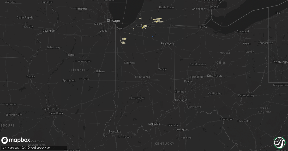
Hail Map in Indiana on August 6, 2021
Get this storm
August 6 map
$229
one time, instant access
Download today. No call, no setup
Keep the $229
Bought the map and want the full workflow? Apply the entire $229 to a subscription within 7 days. None of it is wasted.
Every map, not just this one
This buys you this map. Subscription and you get every map we run, in the markets you choose from a few cities to whole states to nationwide. Plus real-time alerts the moment a storm fires.
Contact data
Name, contact info, occupancy, even credit band for addresses in the footprint. You go from where it hit to who to call.
Become the source they trust
Unlimited branding weather history reports on demand. You already have the documented answer ready for the property owner, and you are the one who showed up with it.
Property data and RoofTrace estimates
Pull up any address you have got, its value and the exact code rules for that jurisdiction, straight from One Click Code. Then RoofTrace estimates the squares, pitch, and roof value, priced the way you price.
Storm reports in Indiana
Indiana
| Date | Description |
|---|---|
| 08/06/20216:00 PM CDT | One inch diameter hail. Basement flooding also reported. |
| 08/06/20215:42 PM CDT | A local report indicates 1.00 inch wind near SOUTH BEND |
| 08/06/20215:20 PM CDT | One snapped tree and some others with branches down... 3-4 inch diameter. |
| 08/06/20215:18 PM CDT | Tree downed. |
| 08/06/20213:30 AM CDT | At 830 PM EDT, severe thunderstorms were located along a line extending from Millersburg to near Ligonier to near Warsaw, moving east at 30 mph. HAZARD...60 mph wind gusts. SOURCE...Radar indicated. IMPACT...Expect damage to roofs, siding, and trees. Locations impacted include... Kendallville, Ligonier, Avilla, Albion, Rome City, Topeka, North Webster, Millersburg, Swan, Wolcottville, Cromwell, Brimfield, Honeyville, Brushy Prairie, Big Long Lake, Lake Wawasee, Plato, Bear Lake, Oswego and Green Center. |
| 08/06/20213:00 AM CDT | At 800 PM EDT, a severe thunderstorm was located near Milford, or near Nappanee, moving east at 30 mph. HAZARD...60 mph wind gusts. SOURCE...Radar indicated. IMPACT...Expect damage to roofs, siding, and trees. Locations impacted include... Warsaw, Nappanee, Syracuse, Milford, North Webster, Leesburg, Oswego, Big Barbee Lake, Monoquet, James Lake, Hastings, Irish Lake, Sechrist Lake, Big Chapman Lake, Lake Wawasee, Clunette, Gravelton, Dewart Lake, Oakwood Park and Tippecanoe Lake. |
| 08/06/202112:47 AM CDT | At 547 PM CDT, a severe thunderstorm was located near Knox, moving east at 25 mph. HAZARD...60 mph wind gusts. SOURCE...Radar indicated. IMPACT...Expect damage to roofs, siding, and trees. Locations impacted include... Knox, North Judson, Hamlet, Koontz Lake, Oak Grove, Toto, Ober, Winona, Bass Lake, Brems and Grovertown. |
| 08/05/20217:20 PM CDT | Tree down onto power line. 600 n at sr 15. |
All States Impacted by Hail Map on August 6, 2021
Cities Impacted by Hail Map on August 6, 2021
- Plymouth, WI
- Rio Rico, AZ
- Hartland, MN
- Wallace, NE
- Dickens, NE
- Kilkenny, MN
- Montgomery, MN
- Hartford, WI
- Richfield, WI
- Hubertus, WI
- Benkelman, NE
- Max, NE
- Canby, MN
- Marietta, MN
- Cedar Grove, WI
- Random Lake, WI
- Fredonia, WI
- Belgium, WI
- Mishawaka, IN
- Miller, SD
- Tucson, AZ
- West Bend, WI
- Kewaskum, WI
- Lander, WY
- Riverton, WY
- Arapahoe, WY
- Crookston, NE
- Sells, AZ
- Johnson Creek, WI
- Lake Mills, WI
- Jefferson, WI
- Reeseville, WI
- Waterloo, WI
- Columbus, WI
- Marshall, WI
- Casper, WY
- Whitewater, WI
- Cambridge, WI
- Fort Atkinson, WI
- Germantown, WI
- Glenrock, WY
- Lefor, ND
- New Leipzig, ND
- Sheboygan Falls, WI
- Waldo, WI
- Kohler, WI
- Sheboygan, WI
- Patagonia, AZ
- Helenville, WI
- Watertown, WI
- Sullivan, WI
- Nogales, AZ
- Fairfax, MN
- Gibbon, MN
- South Bend, IN
- Osceola, IN
- Saint Peter, MN
- Gladstone, ND
- Glenbeulah, WI
- Saint Cloud, WI
- Mount Calvary, WI
- Oconomowoc, WI
- Lusk, WY
- Sturgis, MI
- Newton, WI
- Kiel, WI
- Munds Park, AZ
- Benson, AZ
- Presho, SD
- Ideal, SD
- Winner, SD
- Tombstone, AZ
- Webster, SD
- Doland, SD
- Raymond, SD
- Wheatfield, IN
- Saint Francis, KS
- Centreville, MI
- Aladdin, WY
- Belle Fourche, SD
- Kouts, IN
- Demotte, IN
- Redfield, SD
- Albert Lea, MN
- Clarks Grove, MN
- Hollandale, MN
- Blooming Prairie, MN
- Ellendale, MN
- Buffalo, SD
- Witten, SD
- Gary, SD
- Wanatah, IN
- Stewart, MN
- Campbellsport, WI
- Brownsville, WI
- Fond Du Lac, WI
- Eden, WI
- Oakfield, WI
- Parks, NE
- Verona, WI
- Madison, WI
- Oregon, WI
- Mcfarland, WI
- Eloy, AZ
- Wasta, SD
- Midwest, WY
- Blackstone, IL
- Ashton, IA
- Sheldon, IA
- Dickinson, ND
- Boyden, IA
- Matlock, IA
- Le Sueur, MN
- Cozad, NE
- Edgerton, WI
- Ixonia, WI
- Milton, WI
- Stoughton, WI
- New England, ND
- Allenton, WI
- Union, MI
- Rensselaer, IN
- Fair Oaks, IN
- George, IA
- Taylor, ND
- Mott, ND
- Wessington, SD
- Valentine, NE
- Constantine, MI
- White Pigeon, MI
- Vail, AZ
- Ashton, SD
- Northville, SD
- Clarkfield, MN
- Boyd, MN
- Fulda, MN
- Thayer, IN
- Florence, SD
- Moorcroft, WY
- Saint Lawrence, SD
- Hitchcock, SD
- Lagrange, IN
- Alpine, WY
- Etna, WY
- Wayan, ID
- South Heart, ND
- Mayville, WI
- Granite Falls, MN
- Belfield, ND
- Mendon, MI
- Three Rivers, MI
- Burr Oak, MI
- Jones, MI
- Cochise, AZ
- Beaver Dam, WI
- Henderson, MN
- Belle Plaine, MN
- Elfrida, AZ
- Lomira, WI
- Theresa, WI
- Sundance, WY
- Clear Lake, SD
- Slinger, WI
- Berrien Springs, MI
- Saint David, AZ
- Vandalia, MI
- Burnett, WI
- Juneau, WI
- Horicon, WI
- Waupun, WI
- Cascade, WI
- West Concord, MN
- Dodge Center, MN
- Hector, MN
- Buffalo Lake, MN
- Gillette, WY
- Mission, SD
- Claremont, MN
- Elkhart Lake, WI
- La Porte, IN
- Lonsdale, MN
- Faribault, MN
- Clark, SD
- Wall, SD
- Winona, MN
- Kellogg, MN
- Waterville, MN
- Le Center, MN
- Cleveland, MN
- Henry, SD
- Waubay, SD
- Wallace, SD
- Wabasha, MN
- Fox Lake, WI
- Elkhorn, WI
- Wells, MN
- Delafield, WI
- Nashotah, WI
- Debary, FL
- Grant Park, IL
- Momence, IL
- Altura, MN
- Manville, WY
- Deland, FL
- Lake Helen, FL
- Deltona, FL
- Deerfield, WI
- Martin, SD
- Alden, MN
- Hartley, IA
- Saukville, WI
- Oostburg, WI
- Hartland, WI
- Arivaca, AZ
- Quinn, SD
- Howe, IN
- Fort Washakie, WY
- Cheyenne, WY
- Laramie, WY
- Tie Siding, WY
- Granite Canon, WY
- Livermore, CO
- Buford, WY
- Wellington, CO
- Leesburg, IN
- Rapid City, SD
- Batesland, SD
- Wounded Knee, SD
- Pine Ridge, SD
- Scenic, SD
- Interior, SD
- Philip, SD
- Norris, SD
- Allen, SD
- Parmelee, SD
- Stephan, SD
- Fort Thompson, SD
- Lower Brule, SD
- Ree Heights, SD
- Kennebec, SD
- Reliance, SD
- Hamill, SD
- Highmore, SD
- Wood, SD
- Gann Valley, SD
- Chamberlain, SD
- Chadron, NE
- Burlington, CO
- Bethune, CO


