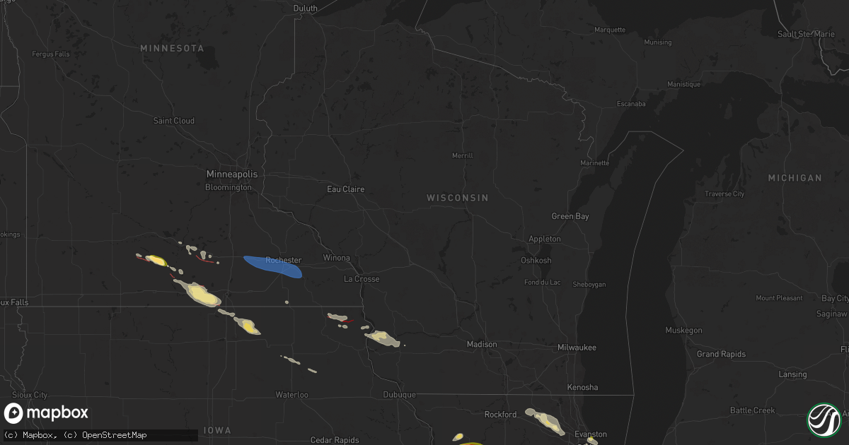
Hail Map in Wisconsin on August 5, 2024
Get this storm
August 5 map
$229
one time, instant access
Download today. No call, no setup
Keep the $229
Bought the map and want the full workflow? Apply the entire $229 to a subscription within 7 days. None of it is wasted.
Every map, not just this one
This buys you this map. Subscription and you get every map we run, in the markets you choose from a few cities to whole states to nationwide. Plus real-time alerts the moment a storm fires.
Contact data
Name, contact info, occupancy, even credit band for addresses in the footprint. You go from where it hit to who to call.
Become the source they trust
Unlimited branding weather history reports on demand. You already have the documented answer ready for the property owner, and you are the one who showed up with it.
Property data and RoofTrace estimates
Pull up any address you have got, its value and the exact code rules for that jurisdiction, straight from One Click Code. Then RoofTrace estimates the squares, pitch, and roof value, priced the way you price.
Storm reports in Wisconsin
Wisconsin
| Date | Description |
|---|---|
| 08/05/20242:09 AM CDT | Barn destroyed and trees down. |
| 08/05/20242:03 AM CDT | Some trees down in whitewater... Richmond and sugar creek. Time estimated from radar. |
| 08/05/202412:55 AM CDT | 4 to 5 reports of trees down on the east side of madison. Some 1 foot in diameter. |
| 08/05/202412:28 AM CDT | A tree down on a house. Other reports of small branches down and power lines down. |
| 08/04/202411:30 PM CDT | A local report indicates 60 MPH wind near 4 WNW Blue River |
| 08/04/202411:30 PM CDT | Large branch downed. Report via social media. Time estimated from radar. |
| 08/04/202411:01 PM CDT | Several trees downed and snapped. Report via social media without photo. Time estimated from radar. |
All States Impacted by Hail Map on August 5, 2024
Cities Impacted by Hail Map on August 5, 2024
- Chicago, IL
- Naperville, IL
- Bolingbrook, IL
- Plainfield, IL
- Oswego, IL
- South Haven, MI
- Holland, MI
- Palos Hills, IL
- Palos Heights, IL
- Palos Park, IL
- Worth, IL
- Chicago Ridge, IL
- Alsip, IL
- Woodridge, IL
- Lemont, IL
- Lockport, IL
- Romeoville, IL
- Crest Hill, IL
- Joliet, IL
- Homer Glen, IL
- Whiting, IN
- East Chicago, IN
- Hammond, IN
- Gary, IN
- New Lenox, IL
- Orland Park, IL
- Mokena, IL
- Manhattan, IL
- Pendleton, OR
- Frankfort, IL
- Monee, IL
- Elwood, IL
- Peotone, IL
- Grant Park, IL
- Manteno, IL
- Momence, IL
- Buffalo, NY
- Putney, VT
- Walpole, NH
- Westmoreland, NH
- Keene, NH
- Sullivan, NH
- Gilsum, NH
- Nelson, NH
- Marlborough, NH
- Weston, CO
- Hancock, NH
- Antrim, NH
- Greenfield, NH
- Bennington, NH
- Harrisville, NH
- Peterborough, NH
- Lyndeborough, NH
- Francestown, NH
- Eaton, NY
- Earlville, NY
- Hamilton, NY
- Hubbardsville, NY
- Waterville, NY
- North Brookfield, NY
- Brookfield, NY
- West Edmeston, NY
- West Winfield, NY
- Owego, NY
- Endicott, NY
- Vestal, NY
- Madison, NY
- Bouckville, NY
- Binghamton, NY
- Corfu, NY
- Darien Center, NY
- Lancaster, NY
- Alden, NY
- Akron, NY
- Apalachin, NY
- Brackney, PA
- Hallstead, PA
- Montrose, PA
- Conklin, NY
- Ponte Vedra, FL
- Saint Augustine, FL
- Morrison, IL
- Willowbrook, IL
- Willow Springs, IL
- Downers Grove, IL
- Darien, IL
- Schaghticoke, NY
- Valley Falls, NY
- Buskirk, NY
- Johnsonville, NY
- Hoosick Falls, NY
- Sterling, IL
- Santa Fe, NM
- Eagle Bridge, NY
- Milledgeville, IL
- Chadwick, IL
- Saint James, MN
- Dixon, IL
- Lanark, IL
- Polo, IL
- Woosung, IL
- Oregon, IL
- Madelia, MN
- Franklin Grove, IL
- Ashton, IL
- Mankato, MN
- Eagle Lake, MN
- Belmont, NH
- Gilmanton, NH
- Darfur, MN
- Lostine, OR
- Wallowa, OR
- Vernon Center, MN
- Alton, NH
- Gilmanton Iron Works, NH
- Center Barnstead, NH
- Amboy, MN
- Lake Village, IN
- Alton Bay, NH
- Morris, IL
- Minooka, IL
- Newark, IL
- Shorewood, IL
- Winnebago, MN
- Farmington, NH
- New Durham, NH
- Janesville, MN
- Pemberton, MN
- Mapleton, MN
- Channahon, IL
- Waseca, MN
- Imnaha, OR
- Delavan, MN
- Easton, MN
- Wells, MN
- Minnesota Lake, MN
- North Berwick, ME
- Lebanon, ME
- Berwick, ME
- Bricelyn, MN
- Blue Earth, MN
- Cottonwood, ID
- Wilmington, IL
- Lordsburg, NM
- Cape Elizabeth, ME
- Alden, MN
- Kiester, MN
- Silver City, NM
- Hurley, NM
- Bayard, NM
- Hanover, NM
- Santa Clara, NM
- Hayfield, MN
- Kasson, MN
- Dodge Center, MN
- Claremont, MN
- Byron, MN
- Rochester, MN
- Stewartville, MN
- Emmons, MN
- Albert Lea, MN
- Twin Lakes, MN
- Conger, MN
- Northwood, IA
- Lake Mills, IA
- Arenas Valley, NM
- White Bird, ID
- Scarville, IA
- Eyota, MN
- Chatfield, MN
- Spring Valley, MN
- Kensett, IA
- Grafton, IA
- Edisto Island, SC
- Johns Island, SC
- Osage, IA
- Manly, IA
- Plymouth, IA
- Le Roy, MN
- Nora Springs, IA
- Rudd, IA
- Decorah, IA
- Waukon, IA
- Dorchester, IA
- Nashua, IA
- Lansing, IA
- Harpers Ferry, IA
- Ionia, IA
- Fredericksburg, IA
- Sumner, IA
- Tripoli, IA
- Frederika, IA
- Waverly, IA
- Steuben, WI
- Wauzeka, WI
- Eastman, WI
- Westgate, IA
- Maynard, IA
- Boscobel, WI
- Woodman, WI
- Fennimore, WI
- Enterprise, OR
- Ferdinand, ID
- Orofino, ID
- Union, IL
- Woodstock, IL
- Marengo, IL
- Harvard, IL
- Huntley, IL
- Moncks Corner, SC
- Pinopolis, SC
- Algonquin, IL
- Lake In The Hills, IL
- Crystal Lake, IL
- Dundee, IL
- Cross, SC
- Eutawville, SC
- Carpentersville, IL
- Cary, IL
- Barrington, IL
- Fox River Grove, IL
- Hoffman Estates, IL
- Oakfield, NY
- Batavia, NY
- Basom, NY
- Elba, NY
- Allegany, NY
- Olean, NY
- Streamwood, IL
- Schaumburg, IL
- Elgin, IL
- Harwood Heights, IL
- Austin, MN
- Grand Meadow, MN
- Charleston, SC
- Isle Of Palms, SC
- Beaufort, SC
- Saint Helena Island, SC


