Hail Map in Anoka, MN on August 5, 2019
The weather event in Anoka, MN on August 5, 2019 includes Wind and Hail maps. 21 states and 511 cities were impacted and suffered possible damage. The total estimated number of properties impacted is 7,518.
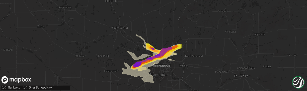
Wind
Hail
7,518
Estimated number of impacted properties by a 1.00" hail or larger3,264
Estimated number of impacted properties by a 1.75" hail or larger2,060
Estimated number of impacted properties by a 2.50" hail or largerStorm reports in Anoka, MN
Anoka, MN
| Date | Description |
|---|---|
| 08/05/20193:58 PM CDT | Photo via facebook. |
| 08/05/20193:57 PM CDT | A local report indicates 1.75 inch wind near 1 NNW ANOKA |
| 08/05/20193:50 PM CDT | Bunker lake blvd and sunfish lake blvd. |
| 08/05/20193:47 PM CDT | A local report indicates 1.25 inch wind near 1 ESE RAMSEY |
| 08/05/20193:46 PM CDT | A local report indicates 2.50 inch wind near 2 SSW RAMSEY |
All States Impacted by Hail Map on August 5, 2019
All Cities Impacted by Hail Map on August 5, 2019
- Sheridan, WY
- Fenton, IA
- Lone Rock, IA
- Bancroft, IA
- Ringsted, IA
- Wheatland, WY
- Worland, WY
- Gilman, WI
- Spencer, WI
- Loyal, WI
- Granton, WI
- Chili, WI
- Hamel, MN
- Long Lake, MN
- Loretto, MN
- Maple Plain, MN
- Utica, MN
- Saint Charles, MN
- Lewiston, MN
- Oelrichs, SD
- Middle Amana, IA
- South Amana, IA
- Marengo, IA
- Amana, IA
- Exeland, WI
- Ladysmith, WI
- Winter, WI
- Fairchild, WI
- Augusta, WI
- New Raymer, CO
- Grover, CO
- Radisson, WI
- Houston, MN
- Rushford, MN
- Saint James, MN
- Kanawha, IA
- Couderay, WI
- Stone Lake, WI
- Hershey, NE
- Wabasha, MN
- Nelson, WI
- Alma, WI
- Reads Landing, MN
- Osseo, WI
- Mccammon, ID
- North Platte, NE
- Anoka, MN
- Dayton, MN
- Elk River, MN
- Minneapolis, MN
- Osseo, MN
- Columbia, MD
- Milaca, MN
- Ogilvie, MN
- Carpenter, WY
- Cheyenne, WY
- Nunn, CO
- Stanley, WI
- Spencer, ID
- Dubois, ID
- Watertown, MN
- Delano, MN
- Keystone, SD
- Hermosa, SD
- Lakin, KS
- Athens, GA
- Willard, WI
- Andover, MN
- Mound, MN
- Mayer, MN
- Scandia, MN
- Saint Bonifacius, MN
- Waconia, MN
- Saint Paul, MN
- Circle Pines, MN
- Excelsior, MN
- Saint Michael, MN
- Forest Lake, MN
- Stillwater, MN
- Hugo, MN
- Wayzata, MN
- New Germany, MN
- Marine On Saint Croix, MN
- Maple Grove, MN
- Spring Park, MN
- Champlin, MN
- Lester Prairie, MN
- Rogers, MN
- Chisago City, MN
- Rice Lake, WI
- Cameron, WI
- Lanse, MI
- Barron, WI
- Clayton, WI
- Elgin, MN
- Plainview, MN
- Eyota, MN
- Truman, MN
- Fairmont, MN
- Winnebago, MN
- Granada, MN
- Eleva, WI
- Harrisburg, IL
- Raleigh, IL
- Galatia, IL
- Withee, WI
- Owen, WI
- Ellsworth, WI
- Torrington, WY
- Dover, MN
- Rochester, MN
- Wisconsin Dells, WI
- Reedsburg, WI
- Oconto, NE
- Millboro, VA
- Warm Springs, VA
- Shawnee, WY
- Pavillion, WY
- Greenwood, WI
- Aitkin, MN
- Lanesboro, MN
- Mabel, MN
- Rockford, MN
- Montrose, MN
- Buffalo, MN
- Mcgregor, MN
- Braham, MN
- Rush City, MN
- Dalbo, MN
- Stanchfield, MN
- Spring Valley, MN
- Michigamme, MI
- Cochrane, WI
- Stockholm, WI
- Lake City, MN
- Pepin, WI
- Broughton, IL
- Macedonia, IL
- Ojibwa, WI
- Chatham, MI
- Spooner, WI
- Brainerd, MN
- Sarona, WI
- Arcadia, WI
- Altura, MN
- Bear Creek, WI
- Clintonville, WI
- Shiocton, WI
- Pittsville, WI
- Clarion, IA
- Elysian, MN
- Janesville, MN
- Custer, SD
- Cologne, MN
- Buffalo Gap, SD
- Oral, SD
- Fairburn, SD
- Thermopolis, WY
- Duchesne, UT
- Hot Springs, SD
- Smithwick, SD
- Algona, IA
- Bruce, WI
- Windom, MN
- Howard Lake, MN
- Glencoe, MN
- Big Lake, MN
- Silver Lake, MN
- Victoria, MN
- Eden Prairie, MN
- Prior Lake, MN
- Plato, MN
- Chanhassen, MN
- Albertville, MN
- Carver, MN
- Hopkins, MN
- Chaska, MN
- Young America, MN
- Minnetonka, MN
- Waverly, MN
- Becker, MN
- Winsted, MN
- Shakopee, MN
- Mancelona, MI
- New Smyrna Beach, FL
- Shell Lake, WI
- Dakota, MN
- Humboldt, IA
- Gilmore City, IA
- Fountain City, WI
- Eldorado, IL
- Ogema, WI
- Catawba, WI
- Prentice, WI
- Phillips, WI
- Brantwood, WI
- Deer Park, WI
- Almena, WI
- Prairie Farm, WI
- Dallas, WI
- Chetek, WI
- Clear Lake, WI
- Osceola, WI
- Amery, WI
- Star Prairie, WI
- Weyerhaeuser, WI
- Eagle Grove, IA
- Renwick, IA
- Lu Verne, IA
- Goldfield, IA
- Corwith, IA
- Belmond, IA
- Brandywine, MD
- Blooming Prairie, MN
- Owatonna, MN
- Onamia, MN
- Hillman, MN
- Maple, WI
- Eagle Bend, MN
- Miltona, MN
- Parkers Prairie, MN
- Preston, MN
- Canton, MN
- Harmony, MN
- Waterloo, IA
- Blue Earth, MN
- Claremont, MN
- Hayfield, MN
- Goodwell, OK
- Kellogg, MN
- Isle, MN
- New Richmond, WI
- Somerset, WI
- Duluth, MN
- Ottosen, IA
- Fall Creek, WI
- Cotton, MN
- Dexter, MN
- Grand Meadow, MN
- Strum, WI
- Plum City, WI
- Durand, WI
- Mondovi, WI
- Neillsville, WI
- Titusville, FL
- Wisconsin Rapids, WI
- Stevens Point, WI
- Rudolph, WI
- Bancroft, WI
- Plover, WI
- Trimont, MN
- Wetmore, MI
- Munising, MI
- Manville, WY
- Trego, WI
- Hager City, WI
- Red Wing, MN
- Taylor, WI
- Blair, WI
- Gillette, WY
- Pierz, MN
- Mora, MN
- Armstrong, IA
- Portage, WI
- Hawkins, WI
- Dodge Center, MN
- Rosholt, WI
- Waseca, MN
- Marshfield, WI
- Staples, MN
- Estherville, IA
- Jackson, MN
- Hugoton, KS
- New Lisbon, WI
- Mauston, WI
- Stewart, MN
- Brownton, MN
- Camp Douglas, WI
- Tamarack, MN
- Hardy, VA
- Moneta, VA
- Goodview, VA
- Burt, IA
- Douglas, WY
- Manson, IA
- Clare, IA
- Vinton, VA
- Le Roy, MN
- Taopi, MN
- Elkton, MN
- Hampton, IA
- Sheffield, IA
- Kendall, KS
- West Bend, IA
- Whittemore, IA
- Newberry, MI
- Jacobson, MN
- Floodwood, MN
- Cokato, MN
- Tomah, WI
- Kendall, WI
- Wilton, WI
- Hustler, WI
- Elroy, WI
- Dickens, NE
- Clifton, AZ
- Morenci, AZ
- Newhall, IA
- Wahkon, MN
- Kasson, MN
- Port Wing, WI
- Iron River, WI
- Bradgate, IA
- Glendo, WY
- Poplar, WI
- South Range, WI
- Boyd, WI
- Thorp, WI
- Humbird, WI
- Wellfleet, NE
- Mount Pleasant, IA
- Pine River, MN
- Motley, MN
- Pequot Lakes, MN
- Maple Lake, MN
- Annandale, MN
- Easton, MN
- Delavan, MN
- Goodell, IA
- Garner, IA
- Britt, IA
- Klemme, IA
- Westboro, WI
- Jim Falls, WI
- Chippewa Falls, WI
- Sioux Rapids, IA
- Greenville, IA
- Prescott, WI
- River Falls, WI
- Jewell, IA
- Lost Springs, WY
- Fairfax, IA
- Norway, IA
- West Concord, MN
- Sturgeon Lake, MN
- Eau Claire, WI
- Hector, MN
- Buffalo Lake, MN
- Alden, MN
- Wells, MN
- Amherst, WI
- Custer, WI
- Good Thunder, MN
- Mankato, MN
- Fountaintown, IN
- Fairland, IN
- Shelbyville, IN
- Warrens, WI
- Spring Grove, MN
- Alpha, MN
- Spirit Lake, IA
- Maiden Rock, WI
- Cadott, WI
- Joice, IA
- Lake Mills, IA
- Leland, IA
- Bluebell, UT
- Gilbert, IA
- Story City, IA
- Hastings, MN
- Lyndon Station, WI
- Thaxton, VA
- Lakeville, MN
- Rollingstone, MN
- Chugwater, WY
- Medford, MN
- Faribault, MN
- Hampton, MN
- Randolph, MN
- Alexander, IA
- Zumbrota, MN
- Grasston, MN
- Amherst Junction, WI
- Verona, WI
- Verndale, MN
- Bonduel, WI
- Black Creek, WI
- Nichols, WI
- Wesley, IA
- Hot Springs, VA
- Ames, IA
- Auburndale, WI
- Kenyon, MN
- Lodi, WI
- Mims, FL
- Meeteetse, WY
- Palisade, MN
- Rowan, IA
- Hollandale, MN
- Clarks Grove, MN
- Lansing, MN
- Albert Lea, MN
- Brownsdale, MN
- Waltham, MN
- Austin, MN
- Bricelyn, MN
- Kiester, MN
- Scarville, IA
- Thompson, IA
- Frost, MN
- Pemberton, MN
- Royal, IA
- Spencer, IA
- Everly, IA
- Primghar, IA
- Sutherland, IA
- Oxford, IA
- Frederic, WI
- Curlew, IA
- Laurens, IA
- Nekoosa, WI
- Cylinder, IA
- Graettinger, IA
- Sheldon, WI
- Medford, WI
- Lublin, WI
- Holcombe, WI
- Thompsonville, IL
- Willernie, MN
- Meservey, IA
- Thornton, IA
- Peterson, MN
- Caledonia, MN
- Hokah, MN
- Garrett, WY
- Deerwood, MN
- Danbury, WI
- Webster, WI
- Summerville, SC
- Farmington, MN
- Skanee, MI
- Zebulon, GA
- Bertha, MN
- Hewitt, MN
- Vining, MN
- Roanoke, VA
- Blue Ridge, VA
- Shafer, MN
- Turtle Lake, WI
- Dresser, WI
- Lake Elmo, MN
- Trempealeau, WI
- Dunnell, MN
- Superior, IA
- Springbrook, WI
- Hayward, WI
- Almond, WI
- Alma Center, WI
- Grand Marais, MI
- Kaukauna, WI
- Madison Lake, MN
- Webb, IA
- Wausau, WI
- Baxter, MN
- Wonewoc, WI
- Keystone, IA
- Bayfield, WI
- Seymour, WI
- Appleton, WI
- Lakefield, MN
- Cannon Falls, MN
- Goodhue, MN
- Mazeppa, MN
- Whitehall, WI
- Independence, WI
- Hixton, WI
- La Crescent, MN
- Minatare, NE
- Scottsbluff, NE
- Hudson, WI
- Ceylon, MN
- Rosemount, MN
- Gwinn, MI
- Milford, IA
- Hancock, MI
- Cumberland, WI
- West Liberty, IA
- Rapid River, MI
- Savage, MN
- Burnsville, MN
- Vinton, IA
- Lehigh, IA
- Swea City, IA
- Smiths Station, AL
- Hanover, MN
- Hackensack, MN
- Backus, MN
- Akeley, MN
- Walker, MN
- Longville, MN
- Remer, MN
- Marquette, MI
- Brookston, MN
- Canyon, MN
- Saginaw, MN
- Alborn, MN
- Cloquet, MN
- Brook Park, MN
- Hinckley, MN
- Sandstone, MN
- Sutherland, NE


