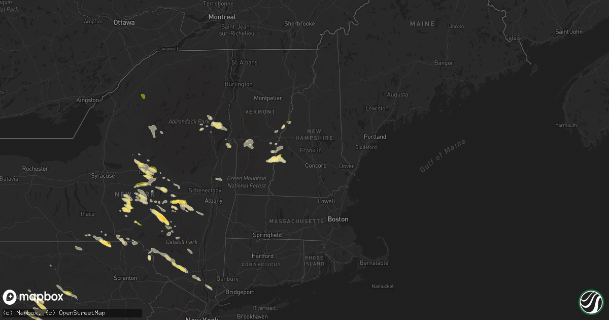
Hail Map in New Hampshire on August 4, 2023
Get this storm
August 4 map
$229
one time, instant access
Download today. No call, no setup
Keep the $229
Bought the map and want the full workflow? Apply the entire $229 to a subscription within 7 days. None of it is wasted.
Every map, not just this one
This buys you this map. Subscription and you get every map we run, in the markets you choose from a few cities to whole states to nationwide. Plus real-time alerts the moment a storm fires.
Contact data
Name, contact info, occupancy, even credit band for addresses in the footprint. You go from where it hit to who to call.
Become the source they trust
Unlimited branding weather history reports on demand. You already have the documented answer ready for the property owner, and you are the one who showed up with it.
Property data and RoofTrace estimates
Pull up any address you have got, its value and the exact code rules for that jurisdiction, straight from One Click Code. Then RoofTrace estimates the squares, pitch, and roof value, priced the way you price.
Storm reports in New Hampshire
New Hampshire
| Date | Description |
|---|---|
| 08/04/20235:10 PM CDT | Observed several downed trees on 2nd nh turnpike between unity and lempster. |
| 08/04/20234:52 PM CDT | Reported by amateur radio. Trees down near exit 13 of interstate 89. Time estimated by radar. |
| 08/04/20234:50 PM CDT | Corrects previous tstm wnd dmg report from 1 ssw grantham. Tree down on road. Time estimated by radar. |
| 08/04/20234:50 PM CDT | Trees and wires down. Time estimated by radar. |
| 08/04/20234:50 PM CDT | Tree down. Time estimated by radar. |
| 08/04/20234:46 PM CDT | Trees and wires down. Time estimated by radar. |
| 08/04/20234:40 PM CDT | Time estimated by radar. |
| 08/04/20234:24 PM CDT | Reported by weather spotter. |
| 08/04/20234:22 PM CDT | Reported by weather spotter. |
| 08/04/20234:12 PM CDT | Delayed report: public reported tree and wires down on twistback road. Time estimated by radar. |
| 08/04/20233:42 PM CDT | Reported by weather spotter. Time estimated by radar. |
| 08/04/20233:42 PM CDT | Reported by weather spotter. Time estimated by radar. |
| 08/04/20233:42 PM CDT | Reported by weather spotter. Time estimated by radar. |
| 08/04/20233:36 PM CDT | Reported by weather spotter. Time estimated by radar. |
| 08/04/20231:02 PM CDT | Reported by weather spotter. Half-dollar size hail reported north of lyme. Time estimated by radar. |
| 08/04/202312:56 PM CDT | Reported by amateur radio. Social media photos of downed trees on river rd near the lyme-orfordville town line. Time estimated by radar. |
All States Impacted by Hail Map on August 4, 2023
Cities Impacted by Hail Map on August 4, 2023
- Waterville, NY
- Cassville, NY
- West Winfield, NY
- Clayville, NY
- Poland, NY
- Utica, NY
- Newport, NY
- Herkimer, NY
- Frankfort, NY
- New Hartford, NY
- Sauquoit, NY
- Ilion, NY
- Apalachin, NY
- Warren Center, PA
- Little Meadows, PA
- Friendsville, PA
- Brackney, PA
- Barton, NY
- Barneveld, NY
- Holland Patent, NY
- New Berlin, NY
- Sherburne, NY
- Edmeston, NY
- West Edmeston, NY
- Schroon Lake, NY
- Montgomery, PA
- Muncy, PA
- Watsontown, PA
- Centre Hall, PA
- Boalsburg, PA
- State College, PA
- Bellefonte, PA
- Orford, NH
- Spring Mills, PA
- Lewistown, PA
- McClure, PA
- Mifflintown, PA
- Richfield, PA
- Oakland Mills, PA
- McAlisterville, PA
- Richmondville, NY
- Warnerville, NY
- Schoharie, NY
- Middleburgh, NY
- Cobleskill, NY
- Fultonham, NY
- Springfield, VT
- Charlestown, NH
- North Clarendon, VT
- Thompsontown, PA
- Newport, PA
- Millerstown, PA
- Plymouth, NY
- Smyrna, NY
- South Plymouth, NY
- Norwich, NY
- Shippensburg, PA
- Newburg, PA
- Amberson, PA
- Spring Run, PA
- Newville, PA
- Walnut Bottom, PA
- Gardners, PA
- Potter, NE
- Sidney, NE
- Lodgepole, NE
- Chappell, NE
- Aspers, PA
- Biglerville, PA
- Orrtanna, PA
- Whitehall, NY
- West Rutland, VT
- Center Rutland, VT
- Rutland, VT
- McDonough, NY
- Oxford, NY
- Oshkosh, NE
- Claremont, NH
- Davenport Center, NY
- Davenport, NY
- East Meredith, NY
- Oneonta, NY
- Delhi, NY
- Bloomville, NY
- Cooperstown, NY
- Springfield Center, NY
- Cherry Valley, NY
- East Springfield, NY
- East Worcester, NY
- Richmond, MO
- Hardin, MO
- Edwards, NY
- Gouverneur, NY
- Rome, NY
- Stittville, NY
- Marcy, NY
- Norborne, MO
- Bovina Center, NY
- Matheson, CO
- Ramah, CO
- Limon, CO
- Hugo, CO
- Ainsworth, NE
- Long Pine, NE
- Purdum, NE
- Johnstown, NE
- Bassett, NE
- Tryon, NE
- Sutherland, NE
- Karval, CO
- North Hudson, NY
- Cheyenne, WY
- Windsor, VT
- South Woodstock, VT
- Whitman, NE
- Arthur, NE
- Hyannis, NE
- Cornish, UT
- Old Forge, NY
- Bridgewater, NY
- Doylesburg, PA
- East Waterford, PA
- Blain, PA
- Hubbardsville, NY
- Madison, NY
- Thetford Center, VT
- East Thetford, VT
- Owego, NY
- Beech Creek, PA
- Whitney, NE
- Paisley, OR
- Mapleton Depot, PA
- Mount Union, PA
- Shirleysburg, PA
- Perkinsville, VT
- Waverly, NY
- Charlotteville, NY
- Jefferson, NY
- Halifax, PA
- Olmstedville, NY
- Williamsport, PA
- Little Rock, AR
- New Lisbon, NY
- Mount Vision, NY
- Garrattsville, NY
- Hope Hull, AL
- Hayneville, AL
- Lowndesboro, AL
- Liberty, PA
- Schenevus, NY
- South Otselic, NY
- Clemons, NY
- Richfield Springs, NY
- Big Sandy, MT
- Dix, NE
- Minerva, NY
- Schaghticoke, NY
- Stillwater, NY
- Rebersburg, PA
- Howard, PA
- Loganton, PA
- Millheim, PA
- Millmont, PA
- Blanchard, PA
- Mill Hall, PA
- Madisonburg, PA
- Coburn, PA
- Orviston, PA
- Aaronsburg, PA
- Milroy, PA
- Woodward, PA
- Geneva, FL
- Osteen, FL
- Oviedo, FL
- West Burlington, NY
- Allenwood, PA
- Mission, SD
- Winner, SD
- Polo, MO
- Rayville, MO
- Little Falls, NY
- Endicott, NY
- Roxbury, NY
- Halcottsville, NY
- Denver, NY
- Goshen, AL
- Troy, AL
- East Wallingford, VT
- Cuttingsville, VT
- Summit, NY
- Morris, PA
- Delancey, NY
- Valentine, NE
- Pickens, AR
- Lockwood, NY
- Chester, VT
- Chiloquin, OR
- Carr, CO
- Nunn, CO
- Milford, NY
- Norwich, VT
- Rensselaerville, NY
- Preston Hollow, NY
- Mill Creek, PA
- McVeytown, PA
- Huntingdon, PA
- Andes, NY
- Margaretville, NY
- Fort Plain, NY
- Rome, PA
- Nichols, NY
- Pine Bluffs, WY
- Bushnell, NE
- Eagle Bay, NY
- Paron, AR
- Benton, AR
- Clarkston, UT
- Cogan Station, PA
- Jersey Shore, PA
- Turbotville, PA
- Danville, PA
- Linden, PA
- Harrisburg, PA
- Duncannon, PA
- Dauphin, PA
- Wallingford, VT
- Okaton, SD
- Gillett, PA
- Columbia Cross Roads, PA
- Ulster, PA
- Milan, PA
- East Smithfield, PA
- Grady, AL
- Ramer, AL
- Montgomery, AL
- Wanblee, SD
- Long Valley, SD
- McGehee, AR
- Worcester, NY
- Lee, FL
- Orbisonia, PA
- Blairs Mills, PA
- Westerlo, NY
- Greenville, NY
- Medusa, NY
- Selma, AL
- Marion, AL
- Mechanicville, NY
- Kimball, NE
- Fairfield, ID
- Mayo, FL
- Day, FL
- White River Junction, VT
- Sharon, VT
- West Hartford, VT
- Fort Pierre, SD
- Monroeville, AL
- Frisco City, AL
- Sprakers, NY
- Canajoharie, NY
- Tillar, AR
- Remsen, NY
- Simla, CO
- Ticonderoga, NY
- Putnam Station, NY
- Hague, NY
- Star City, AR
- Yorktown, AR
- Thedford, NE
- Brookfield, NY
- Earlville, NY
- North Brookfield, NY
- Burlington Flats, NY
- Westernville, NY
- Hensley, AR
- Mabelvale, AR
- Adirondack, NY
- Pottersville, NY
- Gurley, NE
- Hartland, VT
- Thendara, NY
- Lakeview, OR
- Klamath Falls, OR
- Keno, OR
- Letohatchee, AL
- West Fulton, NY
- Concord, PA
- Alexandria, PA
- New Bloomfield, PA
- Liverpool, PA
- Mifflin, PA
- Deltona, FL
- Downey, ID
- Dry Run, PA
- Lemont, PA
- Hartwick, NY
- Mohawk, NY
- Presho, SD
- Lakeland, GA
- Ray City, GA
- Louin, MS
- Rose Hill, MS
- Brewster, NE
- Lower Brule, SD
- Kennebec, SD
- Curtis, NE
- Brady, NE
- North Platte, NE
- Wellfleet, NE
- Moorefield, NE
- Farnam, NE
- Maxwell, NE
- Dickens, NE
- Maywood, NE
- Wallace, NE
- Grant, NE
- Elsie, NE
- Madrid, NE
- Paxton, NE
- Hershey, NE
- Venango, NE
- Ogallala, NE
- Gothenburg, NE
- Cozad, NE
- Bartley, NE
- Cambridge, NE
- Holbrook, NE
- Arapahoe, NE
- Beaver City, NE
- Edison, NE
- Oxford, NE
- Hendley, NE
- Moccasin, MT
- Plainfield, NH
- Ideal, SD
- Lyme, NH
- Tulia, TX
- Springview, NE
- Vivian, SD
- Oberlin, KS
- Norcatur, KS
- Halsey, NE
- Max, NE
- Mansfield, AR
- Hartford, AR
- Booneville, AR
- Rye, CO
- Pueblo, CO
- Avondale, CO
- Lempster, NH
- Newport, NH
- Wood, SD
- Box Elder, MT
- Pilot Grove, MO
- Bunceton, MO
- Cornish, NH
- Ava, NY
- Lee Center, NY
- Murdo, SD
- Haigler, NE
- White River, SD
- Carrollton, MO
- Dover, MO
- Waverly, MO
- Corder, MO
- Malta Bend, MO
- Park Valley, UT
- Draper, SD
- New Windsor, NY
- Highland Falls, NY
- Highland Mills, NY
- Haxtun, CO
- Fleming, CO
- Holyoke, CO
- Wray, CO
- Yuma, CO
- Fowler, CO
- Yorkville, NY
- New York Mills, NY
- Whitesboro, NY
- Saint Francis, KS
- Monticello, NY
- Wurtsboro, NY
- Bloomingburg, NY
- Middletown, NY
- Circleville, NY
- Rock Hill, NY
- Lelia Lake, TX
- Hedley, TX
- Clarendon, TX
- Windsor, NY
- Julesburg, CO
- Grouse Creek, UT
- Jefferson City, MO
- Enders, NE
- Atwood, KS
- Wauneta, NE
- Stratton, NE
- Benkelman, NE
- Imperial, NE
- Turkey, TX
- Crook, CO
- Ovid, CO
- Sedgwick, CO
- Bird City, KS
- Lamar, PA
- Harris, NY
- Liberty, NY
- Kiamesha Lake, NY
- Ferndale, NY
- Swan Lake, NY
- Marshall, MO
- Blackburn, MO
- Saint Francis, SD
- Crookston, NE
- Trenton, NE
- Clarksburg, MO
- California, MO
- Georgetown, NY
- Arrow Rock, MO
- Nelson, MO
- Ellsworth, NE
- Witten, SD
- Grenada, CA
- Peetz, CO
- Sharon Springs, NY
- Fayetteville, PA
- Rosebud, MO
- Gerald, MO
- Rocky Ford, CO
- Blountstown, FL
- Hughesville, MO
- Sedalia, MO
- Susquehanna, PA
- Hamill, SD
- Shade Gap, PA
- Ascutney, VT
- Morris, NY
- Alliance, NE
- Great Bend, PA
- Kirkwood, NY
- Vernon, FL
- Oriskany, NY
- Damascus, PA
- Equinunk, PA
- Champion, NE
- Amherst, CO
- Bainbridge, NY
- Meridale, NY
- West Davenport, NY
- South Fallsburg, NY
- White Sulphur Springs, NY
- Fremont Center, NY
- Roscoe, NY
- Youngsville, NY
- Hankins, NY
- Woodridge, NY
- Callicoon, NY
- Hurleyville, NY
- Livingston Manor, NY
- Glen Wild, NY
- Long Eddy, NY
- Pine Bush, NY
- Montgomery, NY
- Jeffersonville, NY
- North Branch, NY
- Deposit, NY
- South Acworth, NH
- Arkville, NY
- Neelyton, PA
- New Kingston, NY
- Chadron, NE
- West Oneonta, NY
- Conklin, NY
- Alma, MO
- Mountain City, NV
- Malta, ID
- Accord, NY
- Crawford, NE
- Kerhonkson, NY
- McDonald, KS
- Maryland, NY
- Middletown, PA
- Jamestown, MO
- Taylor, NE
- Houstonia, MO
- Sweet Springs, MO
- Starrucca, PA
- Chambersburg, PA
- Orrstown, PA
- Pleasant Hall, PA
- Blooming Grove, NY
- Washingtonville, NY
- Campbell Hall, NY
- McCook, NE
- Culbertson, NE
- Tulelake, CA
- Bonnots Mill, MO
- Linn, MO
- Alturas, CA
- Big Springs, NE
- Prairie Home, MO
- Binghamton, NY
- Sidney, NY
- Montello, NV
- Upperstrasburg, PA
- Russellville, MO
- Lohman, MO
- Hennessey, OK
- Kingfisher, OK
- Unadilla, NY
- Jakin, GA
- Donalsonville, GA
- Centertown, MO
- Tipton, MO
- Matador, TX
- Ludell, KS
- Higginsville, MO
- Padroni, CO
- Live Oak, FL
- Montrose, PA
- Beulah, CO
- Smithton, MO
- Otterville, MO
- Belle, MO
- Bland, MO
- Lindon, CO
- Woodrow, CO
- Anton, CO
- Cope, CO
- Herndon, KS
- Montgomery City, MO
- Galena, KS
- Columbus, KS
- Wolf Lake, IL
- Jonesboro, IL
- Jackson, MO
- Tyler Hill, PA
- Milanville, PA
- Saint Patrick, MO
- Monticello, MO
- Kahoka, MO
- Williamstown, MO
- Patton, MO
- Arriba, CO
- Parks, NE
- Akron, CO
- Norton, KS
- Nauvoo, IL
- Hamilton, IL
- Holts Summit, MO
- Chappaqua, NY
- Millwood, NY
- Ossining, NY
- Cortlandt Manor, NY
- Peekskill, NY
- Croton On Hudson, NY
- Yorktown Heights, NY
- Wellsville, UT
- Palisade, NE
- Cadet, MO
- Quitaque, TX
- Flomot, TX
- Hesston, PA
- James Creek, PA
- Baxter Springs, KS
- Riverton, KS
- Sainte Genevieve, MO
- Hartsburg, MO
- Erie, KS
- McCune, KS
- Saint Paul, KS
- Parsons, KS
- Galesburg, KS
- Albion, ID
- Bonne Terre, MO
- Park Hills, MO
- Farmington, MO
- Sullivan, MO
- Owensville, MO
- Amelia, NE
- Thayer, KS
- Altoona, KS
- Neodesha, KS
- Cassville, PA
- Calvin, PA
- Burley, ID
- Burwell, NE
- Altamont, KS
- Clayton, KS
- Perryville, MO
- Westphalia, MO
- Ashland, MO
- Bloomsdale, MO
- Lock Haven, PA
- Potosi, MO
- Alto Pass, IL
- Blackwell, MO
- Cherryvale, KS
- Ponce De Leon, FL
- Defuniak Springs, FL
- Genoa, CO
- Warrenton, MO
- Wright City, MO
- Jonesburg, MO
- Foristell, MO
- Truesdale, MO
- Three Springs, PA
- Mountainville, NY
- Monroe, NY
- Salisbury Mills, NY
- Wyandotte, OK
- Williamsburg, MO
- Bismarck, MO
- Irondale, MO
- Oswego, KS
- Fredonia, KS
- Greencastle, PA
- Quincy, FL
- Grady, AR
- Waynesboro, PA
- Jennings, KS
- Mineral Point, MO
- Belgrade, MO
- Leadwood, MO
- Lewiston, UT
- Cuba, MO
- Frohna, MO
- Farrar, MO
- Marthasville, MO
- Hermann, MO
- Loose Creek, MO
- Eckley, CO
- Tremonton, UT
- Gould, AR
- Neosho, MO
- Seneca, MO
- Smithfield, UT
- Gregory, SD
- Grand Tower, IL
- Oak Ridge, MO
- Altenburg, MO
- Carl Junction, MO
- Flagler, CO
- Buffalo, OK
- Mooreland, OK
- Lake City, KS
- Freedom, OK
- Coldwater, KS
- Wilmore, KS
- Hardtner, KS
- Medicine Lodge, KS
- Alva, OK
- Mullinville, KS
- Protection, KS
- Ashland, KS
- Haviland, KS
- Sun City, KS
- Minneola, KS
- Bucklin, KS
- Dacoma, OK
- Waynoka, OK
- Kiowa, KS
- Hazelton, KS
- Sharon, KS
- Helena, OK
- Burlington, OK
- Cherokee, OK
- Carmen, OK
- Sawyer, KS
- Isabel, KS
- Coats, KS
- Amorita, OK
- Waldron, KS
- Nashville, KS
- Jet, OK
- Attica, KS
- Anthony, KS
- Harper, KS
- Zenda, KS
- Kingman, KS
- Spivey, KS
- Cunningham, KS
- Argonia, KS
- Norwich, KS
- Danville, KS
- Murdock, KS
- Conway Springs, KS
- Milton, KS
- Wellington, KS
- Winfield, KS
- Oxford, KS
- Mayfield, KS
- Clearwater, KS
- Udall, KS
- Belle Plaine, KS
- Peck, KS
- Geuda Springs, KS
- Arkansas City, KS
- Burden, KS
- Dexter, KS
- Maple City, KS
- Newkirk, OK
- Shidler, OK
- Cambridge, KS
- Cedar Vale, KS
- Sidney Center, NY
- Pawhuska, OK
- Coffeyville, KS
- Liberty, KS
- Uniontown, MO
- Whitewater, KS
- Joplin, MO
- Springfield, MO
- Clarksville, FL
- Bentley, KS
- Sedgwick, KS
- Colwich, KS
- Hobart, NY
- Satanta, KS
- Turon, KS
- Kirk, CO
- Joes, CO
- Stafford, KS
- Iuka, KS
- St John, KS
- Pomona, IL
- Pratt, KS
- Idalia, CO
- Montezuma, KS
- Ensign, KS
- Old Appleton, MO
- Potwin, KS
- Meade, KS
- Quapaw, OK
- Dennis, KS
- Bristol, FL
- Halstead, KS
- Carthage, MO
- El Dorado, KS
- Tamms, IL
- McClure, IL
- Plains, KS
- Diamond, MO
- Ullin, IL
- Dongola, IL
- Sikeston, MO
- Haven, KS
- Hutchinson, KS
- Burrton, KS
- Kanorado, KS
- Troy, MO
- La Harpe, IL
- Carthage, IL
- Mound Valley, KS
- Independence, KS
- Colby, KS
- Follett, TX
- Booker, TX
- Balko, OK
- Darrouzett, TX
- Rocky Comfort, MO
- Pierce City, MO


