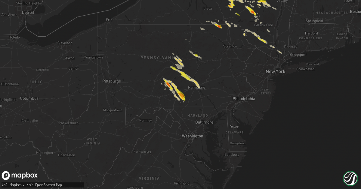
Hail Map on August 4, 2023
Get this storm
August 4 map
$229
one time, instant access
Download today. No call, no setup
Keep the $229
Bought the map and want the full workflow? Apply the entire $229 to a subscription within 7 days. None of it is wasted.
Every map, not just this one
This buys you this map. Subscription and you get every map we run, in the markets you choose from a few cities to whole states to nationwide. Plus real-time alerts the moment a storm fires.
Contact data
Name, contact info, occupancy, even credit band for addresses in the footprint. You go from where it hit to who to call.
Become the source they trust
Unlimited branding weather history reports on demand. You already have the documented answer ready for the property owner, and you are the one who showed up with it.
Property data and RoofTrace estimates
Pull up any address you have got, its value and the exact code rules for that jurisdiction, straight from One Click Code. Then RoofTrace estimates the squares, pitch, and roof value, priced the way you price.
States Impacted by Hail Map on August 4, 2023
Storm reports
New York
| Date | Description |
|---|---|
| 08/04/20236:30 PM CDT | Photo of a tree uprooted. Time estimated by radar. |
| 08/04/20236:16 PM CDT | A local report indicates 1.00 inch wind near 1 NNE Masonville |
| 08/04/20236:04 PM CDT | Picture from social media. Ymouth c |
| 08/04/20236:04 PM CDT | Picture from social media. |
| 08/04/20235:56 PM CDT | Picture from social media. (b |
| 08/04/20235:56 PM CDT | Picture from social media. |
| 08/04/20235:56 PM CDT | Hail damage to cars and a skylight were also observed. |
| 08/04/20235:50 PM CDT | A local report indicates 1.00 inch wind near 2 SW Kortright |
| 08/04/20235:42 PM CDT | A local report indicates 1.00 inch wind near East Meredith |
| 08/04/20235:38 PM CDT | A local report indicates 1.00 inch wind near Meridale |
| 08/04/20235:30 PM CDT | Observer said quarter or larger... But was unsafe to measure until awhile after it fell and melted. |
| 08/04/20235:16 PM CDT | Corrects time previous hail report from 4 ene mc donough. Corrects time previous hail report from 4 ene mc donough. Corrects time previous hail report from 4 ene mc don |
| 08/04/20235:04 PM CDT | A local report indicates 1.00 inch wind near Norwich |
| 08/04/20235:00 PM CDT | Corrects time previous hail report from 3 ne mc donough. |
| 08/04/20235:00 PM CDT | Ping pong ball-sized hail reported at the bowman lake campground. Pictures via social media. |
| 08/04/20234:53 PM CDT | A local report indicates 1.00 inch wind near 3 NE Mc Donough |
| 08/04/20234:52 PM CDT | A local report indicates 1.00 inch wind near 1 N Preston |
| 08/04/20234:52 PM CDT | 5 inch diameter tree branch snapped and fell into a yard. |
| 08/04/20234:25 PM CDT | Power outage in town of easton off gifford road due to a large tree down on a large telephone pole |
| 08/04/20233:24 PM CDT | Along saunders street in whitehall. Time estimated by radar. |
| 08/04/20233:19 PM CDT | Estimated pea to quarter sized hail |
| 08/04/20233:03 PM CDT | Tree fell on car. Unkown if car was occupied. Time estimated based on radar. |
| 08/04/20233:00 PM CDT | Estimated pea to quarter sized hail |
| 08/04/20232:57 PM CDT | Wires down on hust rd and over residence driveway. |
| 08/04/20232:48 PM CDT | A local report indicates 1.50 inch wind near Warnerville |
| 08/04/20232:39 PM CDT | Picture of hail of at least quarter size with some slightly larger. Time estimated by radar. |
| 08/04/20232:24 PM CDT | Picture from social media. |
| 08/04/20232:20 PM CDT | Several trees down across mulitple locations |
| 08/04/20232:12 PM CDT | Trees and wires down along lake shore drive |
| 08/04/20232:10 PM CDT | Tree down on state highway 80... Blocking half of the roadway. |
| 08/04/20232:04 PM CDT | Picture on social media. |
| 08/04/20231:53 PM CDT | Numerous trees down between paradox and chilson. |
| 08/04/20231:36 PM CDT | A local report indicates 1.25 inch wind near 2 N Schroon Lake |
| 08/04/20231:28 PM CDT | At least two trees down |
| 08/04/20231:17 PM CDT | Multiple trees reported down via social media. Time estimated by radar. |
| 08/04/20231:04 PM CDT | Multiple trees down around lake moraine. Pictures shared via social media. Time estimated by radar. |
| 08/04/202312:41 PM CDT | Large tree down on higby road. |
| 08/04/202312:06 PM CDT | Image and video received showing large quantity of quarter-sized hail |
| 08/04/202311:50 AM CDT | Trees and wires down on bush rd at mowers rd. Time estimated from radar. |
| 08/04/202310:34 AM CDT | Picture on social media. |
| 08/04/20239:52 AM CDT | Multiple trees and wires down throughout the city of little falls including along west main street and near the intersection of ny route 5 and south ann street. Also da |
| 08/04/20239:45 AM CDT | Tree uprooted. Time estimated from radar. |
| 08/04/20239:42 AM CDT | Tree and wires down along oregon road in the town of little falls. |
| 08/04/20239:17 AM CDT | Tree down along cedarville road in the town of litchfield. |
| 08/03/20238:08 PM CDT | Large tree down on wires. |
| 08/03/20238:03 PM CDT | Wires down. Time estimated from radar. |
| 08/03/20238:00 PM CDT | Tree and wires down |
| 08/03/20238:00 PM CDT | Tree struck a house and fell onto roadway |
| 08/03/20237:54 PM CDT | Trees and wires down on a house |
| 08/03/20237:54 PM CDT | Multiple spans of wires down in rondout valley campground |
| 08/03/20237:50 PM CDT | A local report indicates 1.00 inch wind near 3 NNW Scotchtown |
| 08/03/20237:48 PM CDT | Tree and wires down across road |
| 08/03/20237:20 PM CDT | Tree and wires down across wolf lake road near the intersection of lake shore dr. E. Tree is completely blocking the road and is burning. |
| 08/03/20237:15 PM CDT | Multiple trees and wires reports down on rock hill dr. |
| 08/03/20237:05 PM CDT | Large tree split near trunk and fell in front yard of residence. |
Nevada
| Date | Description |
|---|---|
| 08/03/20237:42 PM CDT | Antelope lake raws |
Maryland
| Date | Description |
|---|---|
| 08/04/20236:22 PM CDT | One power line reported down due to thunderstorm winds along sixes bridge road. |
| 08/03/20238:54 PM CDT | One tree down due to thundertsorm winds at the intersection of gapland road and shaff road. |
| 08/03/20237:08 PM CDT | One tree down due to thunderstorm winds along the 14000 block of foxville road. |
Vermont
| Date | Description |
|---|---|
| 08/04/20234:42 PM CDT | Second round of quarter sized hail. |
| 08/04/20234:05 PM CDT | Trees down throughout wallingford and middletown springs. |
| 08/04/20233:49 PM CDT | Multiple reports of hail in clarendon. Largest hail stones were up to 1 inch in diameter. |
| 08/04/20233:26 PM CDT | A local report indicates 1.00 inch wind near Springfield |
| 08/04/20233:21 PM CDT | Trees down on boardman hill road |
| 08/04/20233:04 PM CDT | Dime to quarter sized hail reported by the public. |
| 08/04/20232:30 PM CDT | A local report indicates 1.25 inch wind near Benson |
| 08/04/202312:31 PM CDT | Measured by trooper in basin harbor. |
| 08/04/202312:28 PM CDT | Trees down in button bay state park. |
Oklahoma
| Date | Description |
|---|---|
| 08/04/20236:40 AM CDT | Via twitter: large tree limb down in central edmond. |
| 08/04/20233:50 AM CDT | Mesonet station mayr may ranch. |
| 08/04/20233:45 AM CDT | Mesonet station free freedom. |
| 08/04/20233:25 AM CDT | Mesonet station buff buffalo. |
| 08/04/20233:15 AM CDT | Delayed report. |
Texas
| Date | Description |
|---|---|
| 08/03/20238:28 PM CDT | West texas mesonet. Additional severe gusts recorded from 827 pm to 829 pm. |
Kansas
| Date | Description |
|---|---|
| 08/04/20236:45 AM CDT | A local report indicates 60 MPH wind near Dexter |
| 08/04/20236:31 AM CDT | Measured at strother field. |
| 08/04/20236:30 AM CDT | Strother field reported 68 mph wind gust. |
| 08/04/20236:27 AM CDT | A local report indicates 70 MPH wind near 4 SW Winfield |
| 08/04/20236:25 AM CDT | 24 inch diameter tree down in the 1100 block of s 2nd street and 2 inch tree time based on radar. |
| 08/04/20236:25 AM CDT | Tree limbs and a traffic light were damaged on the north side of arkansas city. |
| 08/04/20236:25 AM CDT | Multiple calls of damage throughout the county. Multiple trees limbs and power lines . |
| 08/04/20236:25 AM CDT | Tree knocked down and section of privacy fence blown over by thunderstorm wind gusts. |
| 08/04/20236:21 AM CDT | Measured via personal weather station. |
| 08/04/20236:20 AM CDT | 3 inch tree limbs and power poles down. Time determined by radar. |
| 08/04/20236:20 AM CDT | Kake news reported a semi blown on its side in winfield. |
| 08/04/20236:01 AM CDT | A local report indicates 60 MPH wind near 3 NW Wellington |
| 08/04/20235:45 AM CDT | A local report indicates 65 MPH wind near 4 SW Conway Springs |
| 08/04/20235:26 AM CDT | A local report indicates 60 MPH wind near Norwich |
| 08/04/20235:02 AM CDT | Tree limbs down in town... Low visibility due to blowing dirt. |
| 08/04/20234:56 AM CDT | Asos station kp28 medicine lodge. |
| 08/04/20234:54 AM CDT | A local report indicates 60 MPH wind near Zenda |
| 08/04/20234:45 AM CDT | Delayed report via social media. Quarter to half dollar sized hail observed. |
| 08/03/202310:10 PM CDT | Delayed report. K-state mesonet site in norton reported a 58 mph 10 m wind gust. |
| 08/03/20238:40 PM CDT | Delayed report. K-state mesonet site in ludell reported a 62 mph 10 m wind gust. |
| 08/03/20238:35 PM CDT | Via k-state mesonet site. |
| 08/03/20238:22 PM CDT | Trained spotter estimates thunderstorm wind gust of 60+ mph. |
Florida
| Date | Description |
|---|---|
| 08/04/20236:47 PM CDT | Multiple trees reported down across the county. Time for the southern half of the county estimated by radar. |
| 08/04/20236:38 PM CDT | Em sent photos of a couple trees down near wcfr station 2. Time estimated by radar. |
| 08/04/20236:36 PM CDT | Power outages caused by downed trees and limbs. Time estimated by radar. |
| 08/04/20236:18 PM CDT | Tree reported down near the dogwood lakes area. Time estimated by radar. |
| 08/04/20236:15 PM CDT | Tree and power line reported down. Time estimated by radar. |
| 08/04/20236:13 PM CDT | Multiple trees reported down throughout the county. Time for the northern half of the county estimated by radar. |
| 08/04/20236:08 PM CDT | Tree down near 16825 highway 83. |
| 08/04/20236:02 PM CDT | Tree down. Time estimated by radar. |
| 08/04/20235:37 PM CDT | Trees reported down. Time estimated by radar. |
| 08/04/20235:27 PM CDT | Trees reported down. Time estimated by radar. |
| 08/03/20239:30 PM CDT | A tree blew onto a power line. |
| 08/03/20238:40 PM CDT | Tree down near lanier road and smallpond road. |
| 08/03/20237:25 PM CDT | Tree down along black creek blvd and county highway 3280. |
South Dakota
| Date | Description |
|---|---|
| 08/04/20235:45 PM CDT | A local report indicates 1.75 inch wind near 5 SSE Keyapaha |
| 08/04/20235:37 PM CDT | Hail size ranging from marbles to ping pong balls. |
| 08/03/20238:05 PM CDT | Pws. |
| 08/03/20237:47 PM CDT | A local report indicates 1.25 inch wind near 8 S Cedar Creek Rec Are |
| 08/03/20237:40 PM CDT | Pws. |
Colorado
| Date | Description |
|---|---|
| 08/04/20236:30 PM CDT | Irrigation equipment destroyed. |
| 08/04/20236:26 PM CDT | Mesonet station co034 i-76 julesburg. |
| 08/04/20236:16 PM CDT | Mesonet station co034 i-76 julesburg. |
| 08/04/20234:10 AM CDT | Delayed report via social media. Nickel to golf ball sized hail observed. Time is radar estimated. |
| 08/04/20231:15 AM CDT | Delayed report. Observer reported estimated golf ball sized hail with dents to vehicles. Time is radar estimated. |
New Hampshire
| Date | Description |
|---|---|
| 08/04/20235:10 PM CDT | Observed several downed trees on 2nd nh turnpike between unity and lempster. |
| 08/04/20234:52 PM CDT | Reported by amateur radio. Trees down near exit 13 of interstate 89. Time estimated by radar. |
| 08/04/20234:50 PM CDT | Tree down. Time estimated by radar. |
| 08/04/20234:50 PM CDT | Trees and wires down. Time estimated by radar. |
| 08/04/20234:50 PM CDT | Corrects previous tstm wnd dmg report from 1 ssw grantham. Tree down on road. Time estimated by radar. |
| 08/04/20234:46 PM CDT | Trees and wires down. Time estimated by radar. |
| 08/04/20234:40 PM CDT | Time estimated by radar. |
| 08/04/20234:24 PM CDT | Reported by weather spotter. |
| 08/04/20234:22 PM CDT | Reported by weather spotter. |
| 08/04/20234:12 PM CDT | Delayed report: public reported tree and wires down on twistback road. Time estimated by radar. |
| 08/04/20233:42 PM CDT | Reported by weather spotter. Time estimated by radar. |
| 08/04/20233:42 PM CDT | Reported by weather spotter. Time estimated by radar. |
| 08/04/20233:42 PM CDT | Reported by weather spotter. Time estimated by radar. |
| 08/04/20233:36 PM CDT | Reported by weather spotter. Time estimated by radar. |
| 08/04/20231:02 PM CDT | Reported by weather spotter. Half-dollar size hail reported north of lyme. Time estimated by radar. |
| 08/04/202312:56 PM CDT | Reported by amateur radio. Social media photos of downed trees on river rd near the lyme-orfordville town line. Time estimated by radar. |
Illinois
| Date | Description |
|---|---|
| 08/04/20233:46 AM CDT | A tree was blown on to a police car just east of anna. |
| 08/04/20233:40 AM CDT | Large tree limb down just north of alto pass. |
| 08/04/20232:30 AM CDT | Powerlines and trees down. It is not certain what time the damage occurred due to multiple storms passing over the area. Time is an estimate. Report courtesy of wgem-tv |
| 08/04/20232:30 AM CDT | Shingles removed from the roof of a residence. Windows and garage door blown out. Several trees with damage and corn flattened. Time of occurrence is unknown and is a b |
Georgia
| Date | Description |
|---|---|
| 08/04/20233:54 PM CDT | Trees were blown down in various areas of lowndes county. |
| 08/04/20233:25 PM CDT | Tree down on cooper road. Time estimated by radar. |
| 08/03/20237:19 PM CDT | Ambient weather station reports wind gust of 68 mph. |
Nebraska
| Date | Description |
|---|---|
| 08/04/20236:54 PM CDT | Storm chaser reports quarter sized hail and smaller covering ground... Quickly melting. |
| 08/04/20236:18 PM CDT | Brown/rock county ema reports quarter to golf ball sized hail. |
| 08/04/20234:26 PM CDT | Emergency manager estimated 60 mph winds and pea sized hail in potter. |
| 08/03/20239:50 PM CDT | Numerous broken limbs of greater than 4 inches in diameter at this location. Winds estimated at 60 to 70 mph. |
| 08/03/20239:35 PM CDT | Handheld anemometer. Small winds down as well. |
| 08/03/20239:26 PM CDT | Measured with handheld anemometer. |
| 08/03/20238:26 PM CDT | A local report indicates 74 MPH wind near 9.5 SSE North Platte |
| 08/03/20237:55 PM CDT | Awos station kggf grant airport. |
| 08/03/20237:53 PM CDT | Trained spotter estimates hail up to the size of quarters... Lasting around 5 minutes. |
| 08/03/20237:16 PM CDT | Kiml asos. |
| 08/03/20237:10 PM CDT | Public reports quarter sized hail via social media. |
| 08/03/20237:00 PM CDT | Hail was in progress at time of call. |
Alabama
| Date | Description |
|---|---|
| 08/04/20236:35 PM CDT | Tree down in webb. |
| 08/04/20236:20 PM CDT | Trees reported down. Time estimated by radar. |
| 08/04/20236:14 PM CDT | Tree reported down. Time estimated by radar. |
| 08/04/20236:10 PM CDT | Tree down. Time estimated by radar. |
| 08/04/20235:53 PM CDT | Power line reported down. Time estimated by radar. |
| 08/04/20235:48 PM CDT | Trees down. Time estimated by radar. |
| 08/04/20235:31 PM CDT | Multiple reports of trees and powerlines down in the elba area. |
| 08/04/20234:30 PM CDT | A tree fell on a home on mt. Zion road... Causing significant damage. Multiple trees were downed in the vicinity... Blocking roadways. Reported by montgomery county she |
| 08/04/20234:28 PM CDT | *** 1 inj *** montgomery county sheriffs dispatch and south montgomery county vfd reported multiple trees and powerlines down in and around the ramer community. An inju |
Idaho
| Date | Description |
|---|---|
| 08/04/20235:23 PM CDT | Corrects previous hail report from 8 e fairfield. Largest hailstones reported were estimated quarter-sized... Half-inch hail preceded. Reported under core of storm. |
Oregon
| Date | Description |
|---|---|
| 08/03/20237:55 PM CDT | Quarter-sized hail reported by resort employee. |
| 08/03/20237:50 PM CDT | Ping pong ball-sized hail and heavy rain reported by resort employee. |
Missouri
| Date | Description |
|---|---|
| 08/04/20236:37 PM CDT | Caseys gas station in norborne. |
| 08/04/20236:08 PM CDT | Radar confirmed tornado. Also had reports from a chaser of ongoing tornado. |
| 08/04/20236:08 PM CDT | Damage to a home and outbuildings along highway e. |
| 08/04/20235:57 PM CDT | Chimney toppled and roof damage to a house. |
| 08/03/202311:13 PM CDT | *** 2 inj *** damage to several homes... Power lines... And railroad equipment. People were displaced from their homes and there were 2 minor injuries. |
| 08/03/202311:13 PM CDT | *** 2 inj *** corrects previous tstm wnd dmg report from baring. Damage to several homes... Power lines... And railroad equipment. People were displaced from their home |
| 08/03/202310:17 PM CDT | Trees uprooted lying across bank road in loose creek. |
| 08/03/20238:41 PM CDT | Estimated 60 mph winds south of bunceton. |
| 08/03/20238:06 PM CDT | 60 mph estimate from fire dept in clifton city. |
| 08/03/20237:18 PM CDT | Tornado downed power lines east of malta bend. |
| 08/03/20237:18 PM CDT | Live chaser feed of a tornado near malta bend. No notable damage seen on the video as they went through malta bend along hwy 65. |
| 08/03/20237:04 PM CDT | Waverly apple bbq. |
Mississippi
| Date | Description |
|---|---|
| 08/04/202312:45 PM CDT | Small apartment complex suffered roof/awning damage. |
Pennsylvania
| Date | Description |
|---|---|
| 08/04/20236:40 PM CDT | Multiple trees and powerlines down per franklin county 911 center. |
| 08/04/20235:34 PM CDT | Pema reported trees down on wires between 2nd ave and valley rd in lycoming co. |
| 08/04/20235:32 PM CDT | Report from mping: ping pong ball |
| 08/04/20235:17 PM CDT | Picture from social media shows ping pong sized hail at pine ridge campground. Time estimated by radar. |
| 08/04/20234:55 PM CDT | Trained spotter reports one inch hail diameter in cleversburg. |
| 08/04/20234:35 PM CDT | Report from mping: quarter |
| 08/04/20234:10 PM CDT | Trees and wires down. |
| 08/04/20233:02 PM CDT | Multiple trees trees down on wires. |
| 08/04/20232:20 PM CDT | Trees down on wires. |
| 08/04/20232:12 PM CDT | Trees down on wires. |
| 08/04/20231:36 PM CDT | Trees down on wires northeast of beech creek. |
| 08/04/20231:30 PM CDT | A local report indicates 1.75 inch wind near 1 NE Friendsville |
| 08/04/20231:24 PM CDT | Quarter to golf ball sized hail pictures shared by public to broadcast social media. |
| 08/04/20231:23 PM CDT | Trees and wires down along beech creek mountain road. |
Wyoming
| Date | Description |
|---|---|
| 08/04/20233:30 PM CDT | Commercial weather station measured gust of 58 mph. |
Cities Impacted by Hail Map on August 4, 2023
- Waterville, NY
- Cassville, NY
- West Winfield, NY
- Clayville, NY
- Poland, NY
- Utica, NY
- Newport, NY
- Herkimer, NY
- Frankfort, NY
- New Hartford, NY
- Sauquoit, NY
- Ilion, NY
- Apalachin, NY
- Warren Center, PA
- Little Meadows, PA
- Friendsville, PA
- Brackney, PA
- Barton, NY
- Barneveld, NY
- Holland Patent, NY
- New Berlin, NY
- Sherburne, NY
- Edmeston, NY
- West Edmeston, NY
- Schroon Lake, NY
- Montgomery, PA
- Muncy, PA
- Watsontown, PA
- Centre Hall, PA
- Boalsburg, PA
- State College, PA
- Bellefonte, PA
- Orford, NH
- Spring Mills, PA
- Lewistown, PA
- McClure, PA
- Mifflintown, PA
- Richfield, PA
- Oakland Mills, PA
- McAlisterville, PA
- Richmondville, NY
- Warnerville, NY
- Schoharie, NY
- Middleburgh, NY
- Cobleskill, NY
- Fultonham, NY
- Springfield, VT
- Charlestown, NH
- North Clarendon, VT
- Thompsontown, PA
- Newport, PA
- Millerstown, PA
- Plymouth, NY
- Smyrna, NY
- South Plymouth, NY
- Norwich, NY
- Shippensburg, PA
- Newburg, PA
- Amberson, PA
- Spring Run, PA
- Newville, PA
- Walnut Bottom, PA
- Gardners, PA
- Potter, NE
- Sidney, NE
- Lodgepole, NE
- Chappell, NE
- Aspers, PA
- Biglerville, PA
- Orrtanna, PA
- Whitehall, NY
- West Rutland, VT
- Center Rutland, VT
- Rutland, VT
- McDonough, NY
- Oxford, NY
- Oshkosh, NE
- Claremont, NH
- Davenport Center, NY
- Davenport, NY
- East Meredith, NY
- Oneonta, NY
- Delhi, NY
- Bloomville, NY
- Cooperstown, NY
- Springfield Center, NY
- Cherry Valley, NY
- East Springfield, NY
- East Worcester, NY
- Richmond, MO
- Hardin, MO
- Edwards, NY
- Gouverneur, NY
- Rome, NY
- Stittville, NY
- Marcy, NY
- Norborne, MO
- Bovina Center, NY
- Matheson, CO
- Ramah, CO
- Limon, CO
- Hugo, CO
- Ainsworth, NE
- Long Pine, NE
- Purdum, NE
- Johnstown, NE
- Bassett, NE
- Tryon, NE
- Sutherland, NE
- Karval, CO
- North Hudson, NY
- Cheyenne, WY
- Windsor, VT
- South Woodstock, VT
- Whitman, NE
- Arthur, NE
- Hyannis, NE
- Cornish, UT
- Old Forge, NY
- Bridgewater, NY
- Doylesburg, PA
- East Waterford, PA
- Blain, PA
- Hubbardsville, NY
- Madison, NY
- Thetford Center, VT
- East Thetford, VT
- Owego, NY
- Beech Creek, PA
- Whitney, NE
- Paisley, OR
- Mapleton Depot, PA
- Mount Union, PA
- Shirleysburg, PA
- Perkinsville, VT
- Waverly, NY
- Charlotteville, NY
- Jefferson, NY
- Halifax, PA
- Olmstedville, NY
- Williamsport, PA
- Little Rock, AR
- New Lisbon, NY
- Mount Vision, NY
- Garrattsville, NY
- Hope Hull, AL
- Hayneville, AL
- Lowndesboro, AL
- Liberty, PA
- Schenevus, NY
- South Otselic, NY
- Clemons, NY
- Richfield Springs, NY
- Big Sandy, MT
- Dix, NE
- Minerva, NY
- Schaghticoke, NY
- Stillwater, NY
- Rebersburg, PA
- Howard, PA
- Loganton, PA
- Millheim, PA
- Millmont, PA
- Blanchard, PA
- Mill Hall, PA
- Madisonburg, PA
- Coburn, PA
- Orviston, PA
- Aaronsburg, PA
- Milroy, PA
- Woodward, PA
- Geneva, FL
- Osteen, FL
- Oviedo, FL
- West Burlington, NY
- Allenwood, PA
- Mission, SD
- Winner, SD
- Polo, MO
- Rayville, MO
- Little Falls, NY
- Endicott, NY
- Roxbury, NY
- Halcottsville, NY
- Denver, NY
- Goshen, AL
- Troy, AL
- East Wallingford, VT
- Cuttingsville, VT
- Summit, NY
- Morris, PA
- Delancey, NY
- Valentine, NE
- Pickens, AR
- Lockwood, NY
- Chester, VT
- Chiloquin, OR
- Carr, CO
- Nunn, CO
- Milford, NY
- Norwich, VT
- Rensselaerville, NY
- Preston Hollow, NY
- Mill Creek, PA
- McVeytown, PA
- Huntingdon, PA
- Andes, NY
- Margaretville, NY
- Fort Plain, NY
- Rome, PA
- Nichols, NY
- Pine Bluffs, WY
- Bushnell, NE
- Eagle Bay, NY
- Paron, AR
- Benton, AR
- Clarkston, UT
- Cogan Station, PA
- Jersey Shore, PA
- Turbotville, PA
- Danville, PA
- Linden, PA
- Harrisburg, PA
- Duncannon, PA
- Dauphin, PA
- Wallingford, VT
- Okaton, SD
- Gillett, PA
- Columbia Cross Roads, PA
- Ulster, PA
- Milan, PA
- East Smithfield, PA
- Grady, AL
- Ramer, AL
- Montgomery, AL
- Wanblee, SD
- Long Valley, SD
- McGehee, AR
- Worcester, NY
- Lee, FL
- Orbisonia, PA
- Blairs Mills, PA
- Westerlo, NY
- Greenville, NY
- Medusa, NY
- Selma, AL
- Marion, AL
- Mechanicville, NY
- Kimball, NE
- Fairfield, ID
- Mayo, FL
- Day, FL
- White River Junction, VT
- Sharon, VT
- West Hartford, VT
- Fort Pierre, SD
- Monroeville, AL
- Frisco City, AL
- Sprakers, NY
- Canajoharie, NY
- Tillar, AR
- Remsen, NY
- Simla, CO
- Ticonderoga, NY
- Putnam Station, NY
- Hague, NY
- Star City, AR
- Yorktown, AR
- Thedford, NE
- Brookfield, NY
- Earlville, NY
- North Brookfield, NY
- Burlington Flats, NY
- Westernville, NY
- Hensley, AR
- Mabelvale, AR
- Adirondack, NY
- Pottersville, NY
- Gurley, NE
- Hartland, VT
- Thendara, NY
- Lakeview, OR
- Klamath Falls, OR
- Keno, OR
- Letohatchee, AL
- West Fulton, NY
- Concord, PA
- Alexandria, PA
- New Bloomfield, PA
- Liverpool, PA
- Mifflin, PA
- Deltona, FL
- Downey, ID
- Dry Run, PA
- Lemont, PA
- Hartwick, NY
- Mohawk, NY
- Presho, SD
- Lakeland, GA
- Ray City, GA
- Louin, MS
- Rose Hill, MS
- Brewster, NE
- Lower Brule, SD
- Kennebec, SD
- Curtis, NE
- Brady, NE
- North Platte, NE
- Wellfleet, NE
- Moorefield, NE
- Farnam, NE
- Maxwell, NE
- Dickens, NE
- Maywood, NE
- Wallace, NE
- Grant, NE
- Elsie, NE
- Madrid, NE
- Paxton, NE
- Hershey, NE
- Venango, NE
- Ogallala, NE
- Gothenburg, NE
- Cozad, NE
- Bartley, NE
- Cambridge, NE
- Holbrook, NE
- Arapahoe, NE
- Beaver City, NE
- Edison, NE
- Oxford, NE
- Hendley, NE
- Moccasin, MT
- Plainfield, NH
- Ideal, SD
- Lyme, NH
- Tulia, TX
- Springview, NE
- Vivian, SD
- Oberlin, KS
- Norcatur, KS
- Halsey, NE
- Max, NE
- Mansfield, AR
- Hartford, AR
- Booneville, AR
- Rye, CO
- Pueblo, CO
- Avondale, CO
- Lempster, NH
- Newport, NH
- Wood, SD
- Box Elder, MT
- Pilot Grove, MO
- Bunceton, MO
- Cornish, NH
- Ava, NY
- Lee Center, NY
- Murdo, SD
- Haigler, NE
- White River, SD
- Carrollton, MO
- Dover, MO
- Waverly, MO
- Corder, MO
- Malta Bend, MO
- Park Valley, UT
- Draper, SD
- New Windsor, NY
- Highland Falls, NY
- Highland Mills, NY
- Haxtun, CO
- Fleming, CO
- Holyoke, CO
- Wray, CO
- Yuma, CO
- Fowler, CO
- Yorkville, NY
- New York Mills, NY
- Whitesboro, NY
- Saint Francis, KS
- Monticello, NY
- Wurtsboro, NY
- Bloomingburg, NY
- Middletown, NY
- Circleville, NY
- Rock Hill, NY
- Lelia Lake, TX
- Hedley, TX
- Clarendon, TX
- Windsor, NY
- Julesburg, CO
- Grouse Creek, UT
- Jefferson City, MO
- Enders, NE
- Atwood, KS
- Wauneta, NE
- Stratton, NE
- Benkelman, NE
- Imperial, NE
- Turkey, TX
- Crook, CO
- Ovid, CO
- Sedgwick, CO
- Bird City, KS
- Lamar, PA
- Harris, NY
- Liberty, NY
- Kiamesha Lake, NY
- Ferndale, NY
- Swan Lake, NY
- Marshall, MO
- Blackburn, MO
- Saint Francis, SD
- Crookston, NE
- Trenton, NE
- Clarksburg, MO
- California, MO
- Georgetown, NY
- Arrow Rock, MO
- Nelson, MO
- Ellsworth, NE
- Witten, SD
- Grenada, CA
- Peetz, CO
- Sharon Springs, NY
- Fayetteville, PA
- Rosebud, MO
- Gerald, MO
- Rocky Ford, CO
- Blountstown, FL
- Hughesville, MO
- Sedalia, MO
- Susquehanna, PA
- Hamill, SD
- Shade Gap, PA
- Ascutney, VT
- Morris, NY
- Alliance, NE
- Great Bend, PA
- Kirkwood, NY
- Vernon, FL
- Oriskany, NY
- Damascus, PA
- Equinunk, PA
- Champion, NE
- Amherst, CO
- Bainbridge, NY
- Meridale, NY
- West Davenport, NY
- South Fallsburg, NY
- White Sulphur Springs, NY
- Fremont Center, NY
- Roscoe, NY
- Youngsville, NY
- Hankins, NY
- Woodridge, NY
- Callicoon, NY
- Hurleyville, NY
- Livingston Manor, NY
- Glen Wild, NY
- Long Eddy, NY
- Pine Bush, NY
- Montgomery, NY
- Jeffersonville, NY
- North Branch, NY
- Deposit, NY
- South Acworth, NH
- Arkville, NY
- Neelyton, PA
- New Kingston, NY
- Chadron, NE
- West Oneonta, NY
- Conklin, NY
- Alma, MO
- Mountain City, NV
- Malta, ID
- Accord, NY
- Crawford, NE
- Kerhonkson, NY
- McDonald, KS
- Maryland, NY
- Middletown, PA
- Jamestown, MO
- Taylor, NE
- Houstonia, MO
- Sweet Springs, MO
- Starrucca, PA
- Chambersburg, PA
- Orrstown, PA
- Pleasant Hall, PA
- Blooming Grove, NY
- Washingtonville, NY
- Campbell Hall, NY
- McCook, NE
- Culbertson, NE
- Tulelake, CA
- Bonnots Mill, MO
- Linn, MO
- Alturas, CA
- Big Springs, NE
- Prairie Home, MO
- Binghamton, NY
- Sidney, NY
- Montello, NV
- Upperstrasburg, PA
- Russellville, MO
- Lohman, MO
- Hennessey, OK
- Kingfisher, OK
- Unadilla, NY
- Jakin, GA
- Donalsonville, GA
- Centertown, MO
- Tipton, MO
- Matador, TX
- Ludell, KS
- Higginsville, MO
- Padroni, CO
- Live Oak, FL
- Montrose, PA
- Beulah, CO
- Smithton, MO
- Otterville, MO
- Belle, MO
- Bland, MO
- Lindon, CO
- Woodrow, CO
- Anton, CO
- Cope, CO
- Herndon, KS
- Montgomery City, MO
- Galena, KS
- Columbus, KS
- Wolf Lake, IL
- Jonesboro, IL
- Jackson, MO
- Tyler Hill, PA
- Milanville, PA
- Saint Patrick, MO
- Monticello, MO
- Kahoka, MO
- Williamstown, MO
- Patton, MO
- Arriba, CO
- Parks, NE
- Akron, CO
- Norton, KS
- Nauvoo, IL
- Hamilton, IL
- Holts Summit, MO
- Chappaqua, NY
- Millwood, NY
- Ossining, NY
- Cortlandt Manor, NY
- Peekskill, NY
- Croton On Hudson, NY
- Yorktown Heights, NY
- Wellsville, UT
- Palisade, NE
- Cadet, MO
- Quitaque, TX
- Flomot, TX
- Hesston, PA
- James Creek, PA
- Baxter Springs, KS
- Riverton, KS
- Sainte Genevieve, MO
- Hartsburg, MO
- Erie, KS
- McCune, KS
- Saint Paul, KS
- Parsons, KS
- Galesburg, KS
- Albion, ID
- Bonne Terre, MO
- Park Hills, MO
- Farmington, MO
- Sullivan, MO
- Owensville, MO
- Amelia, NE
- Thayer, KS
- Altoona, KS
- Neodesha, KS
- Cassville, PA
- Calvin, PA
- Burley, ID
- Burwell, NE
- Altamont, KS
- Clayton, KS
- Perryville, MO
- Westphalia, MO
- Ashland, MO
- Bloomsdale, MO
- Lock Haven, PA
- Potosi, MO
- Alto Pass, IL
- Blackwell, MO
- Cherryvale, KS
- Ponce De Leon, FL
- Defuniak Springs, FL
- Genoa, CO
- Warrenton, MO
- Wright City, MO
- Jonesburg, MO
- Foristell, MO
- Truesdale, MO
- Three Springs, PA
- Mountainville, NY
- Monroe, NY
- Salisbury Mills, NY
- Wyandotte, OK
- Williamsburg, MO
- Bismarck, MO
- Irondale, MO
- Oswego, KS
- Fredonia, KS
- Greencastle, PA
- Quincy, FL
- Grady, AR
- Waynesboro, PA
- Jennings, KS
- Mineral Point, MO
- Belgrade, MO
- Leadwood, MO
- Lewiston, UT
- Cuba, MO
- Frohna, MO
- Farrar, MO
- Marthasville, MO
- Hermann, MO
- Loose Creek, MO
- Eckley, CO
- Tremonton, UT
- Gould, AR
- Neosho, MO
- Seneca, MO
- Smithfield, UT
- Gregory, SD
- Grand Tower, IL
- Oak Ridge, MO
- Altenburg, MO
- Carl Junction, MO
- Flagler, CO
- Buffalo, OK
- Mooreland, OK
- Lake City, KS
- Freedom, OK
- Coldwater, KS
- Wilmore, KS
- Hardtner, KS
- Medicine Lodge, KS
- Alva, OK
- Mullinville, KS
- Protection, KS
- Ashland, KS
- Haviland, KS
- Sun City, KS
- Minneola, KS
- Bucklin, KS
- Dacoma, OK
- Waynoka, OK
- Kiowa, KS
- Hazelton, KS
- Sharon, KS
- Helena, OK
- Burlington, OK
- Cherokee, OK
- Carmen, OK
- Sawyer, KS
- Isabel, KS
- Coats, KS
- Amorita, OK
- Waldron, KS
- Nashville, KS
- Jet, OK
- Attica, KS
- Anthony, KS
- Harper, KS
- Zenda, KS
- Kingman, KS
- Spivey, KS
- Cunningham, KS
- Argonia, KS
- Norwich, KS
- Danville, KS
- Murdock, KS
- Conway Springs, KS
- Milton, KS
- Wellington, KS
- Winfield, KS
- Oxford, KS
- Mayfield, KS
- Clearwater, KS
- Udall, KS
- Belle Plaine, KS
- Peck, KS
- Geuda Springs, KS
- Arkansas City, KS
- Burden, KS
- Dexter, KS
- Maple City, KS
- Newkirk, OK
- Shidler, OK
- Cambridge, KS
- Cedar Vale, KS
- Sidney Center, NY
- Pawhuska, OK
- Coffeyville, KS
- Liberty, KS
- Uniontown, MO
- Whitewater, KS
- Joplin, MO
- Springfield, MO
- Clarksville, FL
- Bentley, KS
- Sedgwick, KS
- Colwich, KS
- Hobart, NY
- Satanta, KS
- Turon, KS
- Kirk, CO
- Joes, CO
- Stafford, KS
- Iuka, KS
- St John, KS
- Pomona, IL
- Pratt, KS
- Idalia, CO
- Montezuma, KS
- Ensign, KS
- Old Appleton, MO
- Potwin, KS
- Meade, KS
- Quapaw, OK
- Dennis, KS
- Bristol, FL
- Halstead, KS
- Carthage, MO
- El Dorado, KS
- Tamms, IL
- McClure, IL
- Plains, KS
- Diamond, MO
- Ullin, IL
- Dongola, IL
- Sikeston, MO
- Haven, KS
- Hutchinson, KS
- Burrton, KS
- Kanorado, KS
- Troy, MO
- La Harpe, IL
- Carthage, IL
- Mound Valley, KS
- Independence, KS
- Colby, KS
- Follett, TX
- Booker, TX
- Balko, OK
- Darrouzett, TX
- Rocky Comfort, MO
- Pierce City, MO