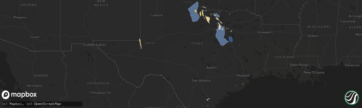
Hail Map in Texas on August 3, 2025
The weather event in Texas on August 3, 2025 includes Hail and Wind maps. 10 states and 345 cities were impacted and suffered possible damage. The total estimated number of properties impacted is 6,740.
Want more than just the map?
Turn this storm into a full workflow.
- Owner + property data so you know who to knock
- OnDemand branded weather history reports to win the "did we even have hail?" argument
- RoofTrace estimate so reps stop guessing numbers at the door
Bought this map? Upgrade within 7 days and we'll credit the $230. (10-15 min setup call)
Hail
Wind
6,740
Estimated number of impacted properties by a 1.00" hail or larger34
Estimated number of impacted properties by a 1.75" hail or larger0
Estimated number of impacted properties by a 2.50" hail or largerStorm reports in Texas
Texas
| Date | Description |
|---|---|
| 08/03/20251:30 PM CDT | Tree down at elematary school on harwood rd in bedford |
| 08/03/20251:25 PM CDT | Facebook report of a few trees blown down at virginia pkwy and lake forest dr. |
| 08/03/20251:12 PM CDT | Facebook report of quarter size hail at fm 157 and bedford rd. |
| 08/03/20251:10 PM CDT | Facebook photos show several trees blown down in the area of hwy 121 and harwood road. One tree fell onto an apartment building and damaged the roof. Another tree fell |
| 08/03/20251:10 PM CDT | Corrects previous tstm wnd dmg report from 1 ene bedford. Tree down at elementary school on harwood rd in bedford |
| 08/03/20251:04 PM CDT | Facebook photo showed a tree down at william d tate ave and timberline dr. |
| 08/03/20255:27 AM CDT | Kgky asos gust to 61 mph at 527 am. |
| 08/03/20255:27 AM CDT | Kgky asos gust t |
| 08/03/20255:19 AM CDT | Kgky gust of 61 mph. |
| 08/03/20254:39 AM CDT | Delayed report. A 90 mph |
| 08/03/20254:39 AM CDT | Delayed report. A regional jet stairway was blown over at dfw airport. Small tree limb damage was also noted at the airport... And construction barrels and barricades w |
| 08/03/20253:50 AM CDT | Delayed report. A downed tree blocked the road near fm 455 and cr 828. |
| 08/03/20252:52 AM CDT | Measured 58 mph wind gust in muenster. |
| 08/02/20257:20 PM CDT | A couple of powerlines and minor roof damage reported by emergency management due to thunderstorm wind gusts. Time was estimated by radar. |
All States Impacted by Hail Map on August 3, 2025
Cities Impacted by Hail Map on August 3, 2025
- Davidson, OK
- Vernon, TX
- Frederick, OK
- Hollister, OK
- Loveland, OK
- Oklaunion, TX
- Harrold, TX
- Electra, TX
- Grandfield, OK
- Chattanooga, OK
- Seymour, TX
- Iowa Park, TX
- Burkburnett, TX
- Holliday, TX
- Newcastle, TX
- Throckmorton, TX
- Olney, TX
- Windthorst, TX
- Argyle, TX
- Custer, SD
- Hot Springs, SD
- Buffalo Gap, SD
- Flower Mound, TX
- Roanoke, TX
- Southlake, TX
- North Richland Hills, TX
- Colleyville, TX
- Keller, TX
- Lewisville, TX
- Bedford, TX
- Euless, TX
- Grapevine, TX
- Hurst, TX
- Fort Worth, TX
- Arlington, TX
- Burleson, TX
- Grand Prairie, TX
- Hill City, SD
- Rapid City, SD
- Goodland, KS
- Arthur, NE
- Clayton, NM
- Hoxie, KS
- Sharon Springs, KS
- Mullen, NE
- Selden, KS
- Grainfield, KS
- Grinnell, KS
- Seneca, NE
- Prairie City, OR
- Wallace, KS
- Kermit, TX
- Sutherland, NE
- Gove, KS
- Lewellen, NE
- Keystone, NE
- Paxton, NE
- Elkhart, TX
- Edgemont, SD
- Brule, NE
- Winner, SD
- Savoy, TX
- Oakley, KS
- Bend, OR
- Roscoe, SD
- Oelrichs, SD
- Tribune, KS
- Colome, SD
- Weskan, KS
- Marsland, NE
- Harrison, NE
- Gregory, SD
- Angleton, TX
- Danbury, TX
- Tryon, NE
- Ogallala, NE
- Monument, OR
- Long Creek, OR
- Monahans, TX
- Mathis, TX
- Sandia, TX
- Ironside, OR
- Springview, NE
- Valentine, NE
- Quinter, KS
- Bay City, TX
- Chadron, NE
- Johnstown, NE
- Beeler, KS
- Dighton, KS
- Dallas, SD
- Mosquero, NM
- Healy, KS
- Scott City, KS
- Alexander, KS
- Jetmore, KS
- Chappell, NE
- Alice, TX
- Burke, SD
- Roy, NM
- Winona, KS
- Riverside, OR
- Whitney, NE
- Garden City, KS
- Cimarron, KS
- Syracuse, KS
- Brogan, OR
- Ashby, NE
- Nekoma, KS
- La Crosse, KS
- Hanston, KS
- McCracken, KS
- Ness City, KS
- Faulkton, SD
- Onaka, SD
- Julesburg, CO
- Rush Center, KS
- Rushville, NE
- Hay Springs, NE
- Gothenburg, NE
- Callaway, NE
- John Day, OR
- Juntura, OR
- Gordon, NE
- Ingalls, KS
- Merriman, NE
- Wood Lake, NE
- Johnson, KS
- Jamieson, OR
- Realitos, TX
- Wright, KS
- Dodge City, KS
- Ford, KS
- Ensign, KS
- Montezuma, KS
- Spearville, KS
- Seneca, SD
- Ellsworth, NE
- Marienthal, KS
- Deerfield, KS
- Holcomb, KS
- Presho, SD
- Kendall, KS
- Manter, KS
- Oacoma, SD
- Reliance, SD
- Thedford, NE
- Bates, OR
- Whitman, NE
- Cody, NE
- Lower Brule, SD
- Chamberlain, SD
- Kennebec, SD
- Ideal, SD
- Lakin, KS
- Elkhart, KS
- Fowler, KS
- Minneola, KS
- Bucklin, KS
- Greensburg, KS
- Mullinville, KS
- Offerle, KS
- Haviland, KS
- Meade, KS
- Englewood, KS
- Ashland, KS
- Protection, KS
- Lake City, KS
- Wilmore, KS
- Coldwater, KS
- Burwell, NE
- Witten, SD
- Sublette, KS
- Satanta, KS
- Ulysses, KS
- Richfield, KS
- Moscow, KS
- Gate, OK
- Harrold, SD
- Taylor, NE
- Rosston, OK
- Buffalo, OK
- Freedom, OK
- Goodwell, OK
- Pratt, KS
- Laverne, OK
- Kismet, KS
- Marion, MT
- Liberal, KS
- Hugoton, KS
- Cunningham, KS
- Isabel, KS
- Hamill, SD
- Shattuck, OK
- May, OK
- Keyes, OK
- Fargo, OK
- Elyria, NE
- Turon, KS
- Follett, TX
- Mooreland, OK
- Fort Supply, OK
- Woodward, OK
- Gage, OK
- Sharon, OK
- Texhoma, OK
- Sargent, NE
- Arnett, OK
- Stratford, TX
- Seiling, OK
- Vici, OK
- Chester, OK
- Mutual, OK
- Gann Valley, SD
- Comstock, NE
- Ord, NE
- Camargo, OK
- Taloga, OK
- Leedey, OK
- Cheyenne, OK
- Crawford, OK
- Clearmont, WY
- Loup City, NE
- Hammon, OK
- Putnam, OK
- Custer City, OK
- Butler, OK
- Elk City, OK
- Canute, OK
- Clinton, OK
- Arapaho, OK
- Weatherford, OK
- Thomas, OK
- Plainview, NE
- Neligh, NE
- Mount Vernon, SD
- Osmond, NE
- Creighton, NE
- Wausa, NE
- Wood River, NE
- Shelton, NE
- Lindsay, NE
- Central City, NE
- Madison, NE
- Bloomfield, NE
- Temple, OK
- Gillette, WY
- Wichita Falls, TX
- Foster, OK
- Elmore City, OK
- Petrolia, TX
- Byers, TX
- Bowie, TX
- Montague, TX
- Saint Jo, TX
- Henrietta, TX
- Muenster, TX
- Forestburg, TX
- Rosston, TX
- Sunset, TX
- Chico, TX
- Jacksboro, TX
- Deshler, NE
- Hebron, NE
- Sanger, TX
- Krum, TX
- Gainesville, TX
- Decatur, TX
- Geneva, NE
- Denton, TX
- Chester, NE
- Lindsay, TX
- Era, TX
- Valley View, TX
- Byron, NE
- Belleville, KS
- Lake Dallas, TX
- Justin, TX
- Bridgeport, TX
- The Colony, TX
- Dallas, TX
- Bellevue, TX
- Irving, TX
- Haltom City, TX
- Kennedale, TX
- Joshua, TX
- Mansfield, TX
- Cleburne, TX
- Alvarado, TX
- Lancaster, TX
- Keene, TX
- Midlothian, TX
- Cedar Hill, TX
- Grandview, TX
- Lillian, TX
- Desoto, TX
- Venus, TX
- Waxahachie, TX
- Red Oak, TX
- Duncanville, TX
- Maypearl, TX
- Wilmer, TX
- Palmer, TX
- Ennis, TX
- Ferris, TX
- Hutchins, TX
- Rio Vista, TX
- Kaufman, TX
- Terrell, TX
- Blum, TX
- Itasca, TX
- Covington, TX
- Italy, TX
- Forreston, TX
- Milford, TX
- Mertens, TX
- Hillsboro, TX
- Bynum, TX
- Scotland, TX
- Abbott, TX
- West, TX
- Malone, TX
- Penelope, TX
- Frost, TX
- Blooming Grove, TX
- Barry, TX
- Purdon, TX
- Dawson, TX
- Hubbard, TX
- Mount Calm, TX
- Corsicana, TX
- Rice, TX
- Powell, TX
- Kerens, TX
- Chatfield, TX
- Coolidge, TX
- Prairie Hill, TX
- Richland, TX
- Wortham, TX
- Streetman, TX
- Fairfield, TX
- Elm Mott, TX
- Axtell, TX
- Mart, TX
- Coppell, TX


