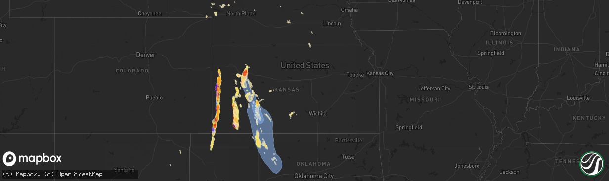
Hail Map in Kansas on August 3, 2025
The weather event in Kansas on August 3, 2025 includes Hail and Wind maps. 10 states and 345 cities were impacted and suffered possible damage. The total estimated number of properties impacted is 12,863.
Want more than just the map?
Turn this storm into a full workflow.
- Owner + property data so you know who to knock
- OnDemand branded weather history reports to win the "did we even have hail?" argument
- RoofTrace estimate so reps stop guessing numbers at the door
Bought this map? Upgrade within 7 days and we'll credit the $230. (10-15 min setup call)
Hail
Wind
12,863
Estimated number of impacted properties by a 1.00" hail or larger6,727
Estimated number of impacted properties by a 1.75" hail or larger2,817
Estimated number of impacted properties by a 2.50" hail or largerStorm reports in Kansas
Kansas
| Date | Description |
|---|---|
| 08/03/20256:48 PM CDT | A local report indicates 2.00 inch wind near 14 S Syracuse |
| 08/03/20256:47 PM CDT | Report received from social media with pictures. |
| 08/03/20256:40 PM CDT | A local report indicates 1.75 inch wind near 9 W Jetmore |
| 08/03/20256:25 PM CDT | Report was from kksdight22 weather station. |
| 08/03/20256:20 PM CDT | A local report indicates 1.75 inch wind near Scott City |
| 08/03/20256:19 PM CDT | A local report indicates 1.00 inch wind near Scott City |
| 08/03/20256:15 PM CDT | Pictures of large tree limb broken. This tree limb was laying on top of a car. |
| 08/03/20256:14 PM CDT | Large tree branches were blown down. |
| 08/03/20256:08 PM CDT | Report was received from awn weather station. |
| 08/03/20256:05 PM CDT | A local report indicates 1.75 inch wind near 5 NNW Scott City |
| 08/03/20256:01 PM CDT | Brief tornado lasting 2-3 minutes... No damage. |
| 08/03/20255:58 PM CDT | Report was from the kansas state mesonet. |
| 08/03/20255:53 PM CDT | A local report indicates 70 MPH wind near Shields |
| 08/03/20255:48 PM CDT | Photos of numerous hail stones from social media next to golf balls. Time estimated. |
| 08/03/20255:48 PM CDT | Multiple reports from chasers of a tornado that briefly touched the ground. Further supported by livestream. Time and location estimated from livestream and radar. Did |
| 08/03/20255:43 PM CDT | Various hail sizes noted. |
| 08/03/20255:33 PM CDT | Site ks-tribune measures 61 mph wind gust. |
| 08/03/20255:31 PM CDT | Photos provided showing hail next to ruler. Time estimated by radar. |
| 08/03/20255:22 PM CDT | Relayed report from dispatch of a tornado that touched the ground and went back up quickly. It was not ongoing as of the report. Time and location estimated from radar. |
| 08/03/20255:19 PM CDT | Corrects previous hail report from 7 s sharon springs. Various hail sizes noted in multiple photos. Caused some damage to travel trailer and barn. |
| 08/03/20255:13 PM CDT | Em relayed report that law enforcement had golf ball sized hail 8 miles south of oakley. |
| 08/03/20255:10 PM CDT | Delayed report of quarter sized hail and 2.10 inches of rainfall. Time estimated by radar. |
| 08/03/20254:59 PM CDT | Spotter reported hail generally around quarters in size... But with a few baseball sized hail stones as well. |
| 08/03/20254:55 PM CDT | Spotter reported quarter sized hail. Lots of hail falling. |
| 08/03/20254:51 PM CDT | Site m |
| 08/03/20254:51 PM CDT | Site my_weather_station |
| 08/03/20254:49 PM CDT | Hailed along the highway... Estimated at half dollar size. |
| 08/03/20254:40 PM CDT | Delayed entry. Social media report of hail up to quarters in size. |
| 08/03/20254:39 PM CDT | Tree damage occurred on county road u... Between county roads 26 and 30. Rotation was present... But there was no visual confirmation of a tornado. |
| 08/03/20254:35 PM CDT | Delayed report. Social media report of hail ranging from golf ball to baseball in size. Time estimated from radar. |
| 08/03/20254:30 PM CDT | Image of hailstones larger than half dollars from sharon springs from social media. |
| 08/03/20254:25 PM CDT | Wind-driven baseball-sized hail damaged vehicles along i-70... Including the destruction of windshields. Report was relayed by broadcast media and time was estimated by |
| 08/03/20254:20 PM CDT | Photo showing a hailstone of at least golf ball size... Perhaps as large as two inches. Additional photos show the back window of a vehicle on i-70 near grainfield was |
| 08/03/20254:15 PM CDT | Quarter to ping pong sized hail reported via social media. |
| 08/03/20254:00 PM CDT | Reported between 2:55 and 3:05 pm mdt. |
| 08/03/20253:40 PM CDT | Up to golf ball sized hail reported for 20 minutes. 0.55 inches of rainfall accompanied the thunderstorm. |
| 08/03/20253:27 PM CDT | Reported via social media. |
| 08/02/20258:37 PM CDT | Report received from social media with pictures. |
| 08/02/20258:33 PM CDT | A local report indicates 1.00 inch wind near Sublette |
| 08/02/20258:30 PM CDT | Twenty-five freight cars were derailed on highway 54 east of kingsdown. |
| 08/02/20258:30 PM CDT | Report was from the kansas state mesonet. |
| 08/02/20258:30 PM CDT | A local report indicates 1.75 inch wind near Satanta |
| 08/02/20258:30 PM CDT | 25 freight cars were derailed on highway 54 east of kingsdown. |
| 08/02/20258:17 PM CDT | A local report indicates 2.75 inch wind near 10 W Richfield |
| 08/02/20258:05 PM CDT | Report from an awn weather station. |
| 08/02/20258:04 PM CDT | Mesonet station up372 2.3 w mullinville |
| 08/02/20258:04 PM CDT | Mesonet station up372 2.3 w mullinville. |
| 08/02/20258:00 PM CDT | Mesonet station dw9907 bloom. |
| 08/02/20257:58 PM CDT | Mesonet station up835 3.0 w kingsdown. |
| 08/02/20257:57 PM CDT | Mesonet station up367 4.9 ne meade. |
| 08/02/20257:57 PM CDT | Mesonet station up367 4.9 ne meade |
| 08/02/20257:54 PM CDT | Asos station kgck garden city. |
| 08/02/20257:52 PM CDT | Asos station kddc dodge city regional airport. |
| 08/02/20257:51 PM CDT | Report was from awn weather station 4 ene ford. |
| 08/02/20257:50 PM CDT | Report from mesonet station k5frd 3wnw ford. |
| 08/02/20257:42 PM CDT | A local report indicates 4.00 inch wind near 7 S Manter |
| 08/02/20257:39 PM CDT | Large tree branches were blown down. |
| 08/02/20257:39 PM CDT | A local report indicates 2.75 inch wind near 3 S Manter |
| 08/02/20257:35 PM CDT | A local report indicates 1.75 inch wind near Deerfield |
| 08/02/20257:30 PM CDT | A local report indicates 3.00 inch wind near Manter |
| 08/02/20257:30 PM CDT | Large tree branches were blown down. |
| 08/02/20257:30 PM CDT | Mesonet station cw9785 dodge city. |
| 08/02/20257:25 PM CDT | Large tree limbs were blown down and power poles were downed. |
| 08/02/20257:25 PM CDT | Tree fell on top of house and cars. |
| 08/02/20257:24 PM CDT | Tree branches down in town. |
| 08/02/20257:24 PM CDT | Wind blew siding and shingles off of building. |
| 08/02/20257:20 PM CDT | Shingles were blown off roof of residence. |
| 08/02/20257:20 PM CDT | Mesonet station spuk1 spearville. |
| 08/02/20257:18 PM CDT | Report was from pws-kksdodge59 weather station. |
| 08/02/20257:18 PM CDT | Report was from an awn weather station 5 n dodge city. |
| 08/02/20257:16 PM CDT | Report was from pws-kksdodge27 weather station. |
| 08/02/20257:16 PM CDT | Report was from pws-kksdodge57 weather station. |
| 08/02/20257:15 PM CDT | Multiple trees were damaged. |
| 08/02/20257:14 PM CDT | Report was from awn weather station 3 wnw dodge city. |
| 08/02/20257:14 PM CDT | Report was from awn weather station. |
| 08/02/20257:13 PM CDT | Several large tree branches were blown down. |
| 08/02/20257:01 PM CDT | A local report indicates 1.75 inch wind near 6 N Johnson City |
| 08/02/20257:00 PM CDT | A local report indicates 82 MPH wind near 2 N Dodge City |
All States Impacted by Hail Map on August 3, 2025
Cities Impacted by Hail Map on August 3, 2025
- Davidson, OK
- Vernon, TX
- Frederick, OK
- Hollister, OK
- Loveland, OK
- Oklaunion, TX
- Harrold, TX
- Electra, TX
- Grandfield, OK
- Chattanooga, OK
- Seymour, TX
- Iowa Park, TX
- Burkburnett, TX
- Holliday, TX
- Newcastle, TX
- Throckmorton, TX
- Olney, TX
- Windthorst, TX
- Argyle, TX
- Custer, SD
- Hot Springs, SD
- Buffalo Gap, SD
- Flower Mound, TX
- Roanoke, TX
- Southlake, TX
- North Richland Hills, TX
- Colleyville, TX
- Keller, TX
- Lewisville, TX
- Bedford, TX
- Euless, TX
- Grapevine, TX
- Hurst, TX
- Fort Worth, TX
- Arlington, TX
- Burleson, TX
- Grand Prairie, TX
- Hill City, SD
- Rapid City, SD
- Goodland, KS
- Arthur, NE
- Clayton, NM
- Hoxie, KS
- Sharon Springs, KS
- Mullen, NE
- Selden, KS
- Grainfield, KS
- Grinnell, KS
- Seneca, NE
- Prairie City, OR
- Wallace, KS
- Kermit, TX
- Sutherland, NE
- Gove, KS
- Lewellen, NE
- Keystone, NE
- Paxton, NE
- Elkhart, TX
- Edgemont, SD
- Brule, NE
- Winner, SD
- Savoy, TX
- Oakley, KS
- Bend, OR
- Roscoe, SD
- Oelrichs, SD
- Tribune, KS
- Colome, SD
- Weskan, KS
- Marsland, NE
- Harrison, NE
- Gregory, SD
- Angleton, TX
- Danbury, TX
- Tryon, NE
- Ogallala, NE
- Monument, OR
- Long Creek, OR
- Monahans, TX
- Mathis, TX
- Sandia, TX
- Ironside, OR
- Springview, NE
- Valentine, NE
- Quinter, KS
- Bay City, TX
- Chadron, NE
- Johnstown, NE
- Beeler, KS
- Dighton, KS
- Dallas, SD
- Mosquero, NM
- Healy, KS
- Scott City, KS
- Alexander, KS
- Jetmore, KS
- Chappell, NE
- Alice, TX
- Burke, SD
- Roy, NM
- Winona, KS
- Riverside, OR
- Whitney, NE
- Garden City, KS
- Cimarron, KS
- Syracuse, KS
- Brogan, OR
- Ashby, NE
- Nekoma, KS
- La Crosse, KS
- Hanston, KS
- McCracken, KS
- Ness City, KS
- Faulkton, SD
- Onaka, SD
- Julesburg, CO
- Rush Center, KS
- Rushville, NE
- Hay Springs, NE
- Gothenburg, NE
- Callaway, NE
- John Day, OR
- Juntura, OR
- Gordon, NE
- Ingalls, KS
- Merriman, NE
- Wood Lake, NE
- Johnson, KS
- Jamieson, OR
- Realitos, TX
- Wright, KS
- Dodge City, KS
- Ford, KS
- Ensign, KS
- Montezuma, KS
- Spearville, KS
- Seneca, SD
- Ellsworth, NE
- Marienthal, KS
- Deerfield, KS
- Holcomb, KS
- Presho, SD
- Kendall, KS
- Manter, KS
- Oacoma, SD
- Reliance, SD
- Thedford, NE
- Bates, OR
- Whitman, NE
- Cody, NE
- Lower Brule, SD
- Chamberlain, SD
- Kennebec, SD
- Ideal, SD
- Lakin, KS
- Elkhart, KS
- Fowler, KS
- Minneola, KS
- Bucklin, KS
- Greensburg, KS
- Mullinville, KS
- Offerle, KS
- Haviland, KS
- Meade, KS
- Englewood, KS
- Ashland, KS
- Protection, KS
- Lake City, KS
- Wilmore, KS
- Coldwater, KS
- Burwell, NE
- Witten, SD
- Sublette, KS
- Satanta, KS
- Ulysses, KS
- Richfield, KS
- Moscow, KS
- Gate, OK
- Harrold, SD
- Taylor, NE
- Rosston, OK
- Buffalo, OK
- Freedom, OK
- Goodwell, OK
- Pratt, KS
- Laverne, OK
- Kismet, KS
- Marion, MT
- Liberal, KS
- Hugoton, KS
- Cunningham, KS
- Isabel, KS
- Hamill, SD
- Shattuck, OK
- May, OK
- Keyes, OK
- Fargo, OK
- Elyria, NE
- Turon, KS
- Follett, TX
- Mooreland, OK
- Fort Supply, OK
- Woodward, OK
- Gage, OK
- Sharon, OK
- Texhoma, OK
- Sargent, NE
- Arnett, OK
- Stratford, TX
- Seiling, OK
- Vici, OK
- Chester, OK
- Mutual, OK
- Gann Valley, SD
- Comstock, NE
- Ord, NE
- Camargo, OK
- Taloga, OK
- Leedey, OK
- Cheyenne, OK
- Crawford, OK
- Clearmont, WY
- Loup City, NE
- Hammon, OK
- Putnam, OK
- Custer City, OK
- Butler, OK
- Elk City, OK
- Canute, OK
- Clinton, OK
- Arapaho, OK
- Weatherford, OK
- Thomas, OK
- Plainview, NE
- Neligh, NE
- Mount Vernon, SD
- Osmond, NE
- Creighton, NE
- Wausa, NE
- Wood River, NE
- Shelton, NE
- Lindsay, NE
- Central City, NE
- Madison, NE
- Bloomfield, NE
- Temple, OK
- Gillette, WY
- Wichita Falls, TX
- Foster, OK
- Elmore City, OK
- Petrolia, TX
- Byers, TX
- Bowie, TX
- Montague, TX
- Saint Jo, TX
- Henrietta, TX
- Muenster, TX
- Forestburg, TX
- Rosston, TX
- Sunset, TX
- Chico, TX
- Jacksboro, TX
- Deshler, NE
- Hebron, NE
- Sanger, TX
- Krum, TX
- Gainesville, TX
- Decatur, TX
- Geneva, NE
- Denton, TX
- Chester, NE
- Lindsay, TX
- Era, TX
- Valley View, TX
- Byron, NE
- Belleville, KS
- Lake Dallas, TX
- Justin, TX
- Bridgeport, TX
- The Colony, TX
- Dallas, TX
- Bellevue, TX
- Irving, TX
- Haltom City, TX
- Kennedale, TX
- Joshua, TX
- Mansfield, TX
- Cleburne, TX
- Alvarado, TX
- Lancaster, TX
- Keene, TX
- Midlothian, TX
- Cedar Hill, TX
- Grandview, TX
- Lillian, TX
- Desoto, TX
- Venus, TX
- Waxahachie, TX
- Red Oak, TX
- Duncanville, TX
- Maypearl, TX
- Wilmer, TX
- Palmer, TX
- Ennis, TX
- Ferris, TX
- Hutchins, TX
- Rio Vista, TX
- Kaufman, TX
- Terrell, TX
- Blum, TX
- Itasca, TX
- Covington, TX
- Italy, TX
- Forreston, TX
- Milford, TX
- Mertens, TX
- Hillsboro, TX
- Bynum, TX
- Scotland, TX
- Abbott, TX
- West, TX
- Malone, TX
- Penelope, TX
- Frost, TX
- Blooming Grove, TX
- Barry, TX
- Purdon, TX
- Dawson, TX
- Hubbard, TX
- Mount Calm, TX
- Corsicana, TX
- Rice, TX
- Powell, TX
- Kerens, TX
- Chatfield, TX
- Coolidge, TX
- Prairie Hill, TX
- Richland, TX
- Wortham, TX
- Streetman, TX
- Fairfield, TX
- Elm Mott, TX
- Axtell, TX
- Mart, TX
- Coppell, TX


