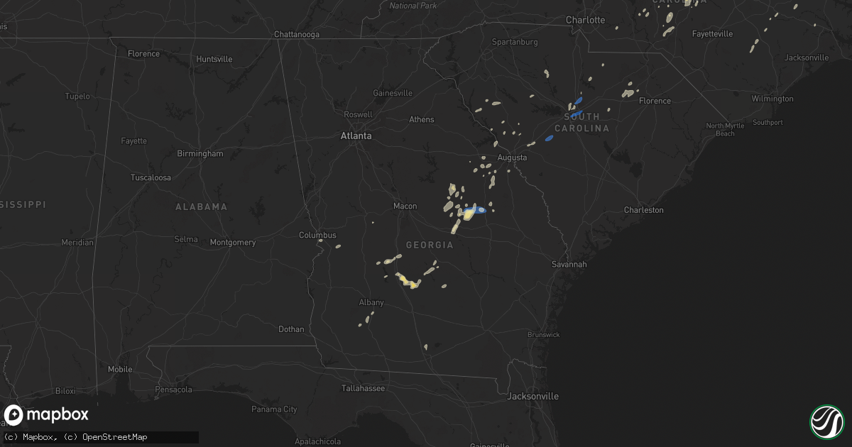
Hail Map in Georgia on August 3, 2024
Get this storm
August 3 map
$229
one time, instant access
Download today. No call, no setup
Keep the $229
Bought the map and want the full workflow? Apply the entire $229 to a subscription within 7 days. None of it is wasted.
Every map, not just this one
This buys you this map. Subscription and you get every map we run, in the markets you choose from a few cities to whole states to nationwide. Plus real-time alerts the moment a storm fires.
Contact data
Name, contact info, occupancy, even credit band for addresses in the footprint. You go from where it hit to who to call.
Become the source they trust
Unlimited branding weather history reports on demand. You already have the documented answer ready for the property owner, and you are the one who showed up with it.
Property data and RoofTrace estimates
Pull up any address you have got, its value and the exact code rules for that jurisdiction, straight from One Click Code. Then RoofTrace estimates the squares, pitch, and roof value, priced the way you price.
Storm reports in Georgia
Georgia
| Date | Description |
|---|---|
| 08/03/20245:40 PM CDT | Six power poles downed along hatley road in between arabi williford rd and stokes rd. Just off of east ga hwy 90. |
| 08/03/20245:35 PM CDT | One structure along us hwy 221 north of kite with some shingles off a modular home. |
| 08/03/20245:23 PM CDT | 1 inch hail report at hatley rd and ga 90. |
| 08/03/20245:15 PM CDT | 1 inch hail reported by em at cannon branch rd and cannon rd. |
| 08/03/20245:05 PM CDT | One tree down on hwy 57 just west of downtown wrightsville. |
| 08/03/20242:20 PM CDT | Augusta/richmond dispatch reported a tree down along oakland ave in augusta. |
| 08/03/20241:59 PM CDT | Columbia county dispatch reported a tree fell on a power line at lone oak and gordon hwy. |
| 08/03/20241:58 PM CDT | Columbia county dispatch reported tree fell on a residence along creekview cir in evans. No injuries. |
| 08/03/20241:36 PM CDT | Columbia county dispatch reported tree fell on power line at cottonwood dr and old thompson rd. |
| 08/03/20241:27 PM CDT | Columbia county dispatch reported trees down along appling harlem rd and i-20. |
All States Impacted by Hail Map on August 3, 2024
Cities Impacted by Hail Map on August 3, 2024
- Lancaster, MN
- Greenbush, MN
- Badger, MN
- Wannaska, MN
- Grygla, MN
- Roseau, MN
- Big Falls, MN
- Littlefork, MN
- Roosevelt, MN
- Warroad, MN
- Salol, MN
- Waskish, MN
- Kelliher, MN
- Mizpah, MN
- Northome, MN
- Wirt, MN
- Baudette, MN
- Williams, MN
- Carlisle, PA
- Max, MN
- Mount Holly Springs, PA
- Trinity, NC
- High Point, NC
- Lena, LA
- Cloutierville, LA
- Blackduck, MN
- Hines, MN
- Redby, MN
- Puposky, MN
- Tenstrike, MN
- Meadville, MS
- Bude, MS
- Gonzales, LA
- Randleman, NC
- Greensboro, NC
- Bangor, PA
- Mount Bethel, PA
- Squaw Lake, MN
- Enola, PA
- Blairstown, NJ
- Columbia, NJ
- Livingston, LA
- Portland, PA
- Calhoun Falls, SC
- Loman, MN
- Bemidji, MN
- Liberty, NC
- Blair, SC
- Julian, NC
- Deer River, MN
- Whitsett, NC
- Burlington, NC
- Springfield, LA
- Summerdale, PA
- Harrisburg, PA
- Marysville, PA
- Smithdale, MS
- Liberty, MS
- Summit, MS
- Edgefield, SC
- Abbeville, SC
- Skipwith, VA
- Marshville, NC
- Newton, NJ
- Pennington, MN
- Andover, NJ
- Spring Lake, MN
- Magnolia, MS
- Clinton, NC
- Rose Hill, NC
- Ramseur, NC
- Seagrove, NC
- Bigfork, MN
- Newberry, SC
- Greenwood, SC
- Olyphant, PA
- Jessup, PA
- Graham, NC
- Chase City, VA
- Warfordsburg, PA
- Needmore, PA
- Big Cove Tannery, PA
- Lafayette, NJ
- Johnston, SC
- Scranton, PA
- Siler City, NC
- Turkey, NC
- Lumberton, MS
- Gibson, GA
- Stapleton, GA
- Laporte, MN
- Cove City, NC
- Dudley, NC
- Mount Olive, NC
- Warrenton, GA
- Sparta, NJ
- Archbald, PA
- Lake Ariel, PA
- Talmoon, MN
- Waymart, PA
- Grand Rapids, MN
- Cohasset, MN
- Seven Springs, NC
- Faison, NC
- Reynolds, GA
- Union Springs, AL
- Banks, AL
- Gatzke, MN
- Middle River, MN
- Roxboro, NC
- Mercersburg, PA
- Weatherly, PA
- La Grange, NC
- Goldsboro, NC
- Seale, AL
- Annville, PA
- Palmyra, PA
- Dozier, AL
- Andalusia, AL
- Bovey, MN
- Oak Ridge, NJ
- Appling, GA
- Haw River, NC
- Pittsboro, NC
- Carlisle, SC
- Charles Town, WV
- Heath Springs, SC
- Hershey, PA
- Hummelstown, PA
- Dearing, GA
- Columbia, SC
- Blythewood, SC
- Berryville, VA
- Thomson, GA
- Newfoundland, NJ
- Coleraine, MN
- Lake Harmony, PA
- Summit Point, WV
- Harpers Ferry, WV
- Bluemont, VA
- Round Hill, VA
- Purcellville, VA
- Hamilton, VA
- Waterford, VA
- Lovettsville, VA
- Belvidere, NJ
- Mount Hermon, LA
- Jim Thorpe, PA
- Albrightsville, PA
- Lebanon, PA
- Jonestown, PA
- Fort Benning, GA
- Kenbridge, VA
- Harlem, GA
- Camden, SC
- Donaldsonville, LA
- Modoc, SC
- Kinston, NC
- Hookerton, NC
- Saluda, SC
- Bristol, FL
- Red Level, AL
- Paeonian Springs, VA
- Leesburg, VA
- Kershaw, SC
- Blakeslee, PA
- Robeline, LA
- Cusseta, GA
- Meherrin, VA
- Victoria, VA
- Beaver, OK
- Durham, NC
- Chapel Hill, NC
- Apex, NC
- Plum Branch, SC
- Long Pond, PA
- Pocono Lake, PA
- Park Ridge, NJ
- Saddle River, NJ
- Monsey, NY
- Woodcliff Lake, NJ
- Pearl River, NY
- Nanuet, NY
- Spring Valley, NY
- Montvale, NJ
- McCormick, SC
- Buena Vista, GA
- Henryville, PA
- Cresco, PA
- Red Lake Falls, MN
- West Nyack, NY
- Lunenburg, VA
- Baskerville, VA
- Valley Cottage, NY
- Morrisville, NC
- Paris, VA
- Boyce, VA
- Hephzibah, GA
- Pocono Summit, PA
- Mount Pocono, PA
- Swiftwater, PA
- Dundas, VA
- New City, NY
- Orangeburg, NY
- Congers, NY
- Ho Ho Kus, NJ
- Allendale, NJ
- Nyack, NY
- Waldwick, NJ
- Mount Gretna, PA
- York, PA
- Folsom, LA
- Alberta, VA
- Blackstone, VA
- Manheim, PA
- Bartonsville, PA
- Tannersville, PA
- Stroudsburg, PA
- East Stroudsburg, PA
- Cary, NC
- Rawlings, VA
- McKenney, VA
- Boydton, VA
- Wake Forest, NC
- Creedmoor, NC
- Oxford, NC
- Covington, LA
- Loranger, LA
- Ossining, NY
- Chappaqua, NY
- Blauvelt, NY
- Township Of Washington, NJ
- Hillsdale, NJ
- Briarcliff Manor, NY
- Ridgewood, NJ
- South Hill, VA
- Bullock, NC
- Mount Gilead, NC
- Candor, NC
- Walker, LA
- Holden, LA
- Troy, NC
- Franklinton, NC
- Sandersville, GA
- Warthen, GA
- Lititz, PA
- Tickfaw, LA
- Upperville, VA
- Hammond, LA
- Raleigh, NC
- Kittrell, NC
- Windsor, PA
- Wrightsville, PA
- Hawthorne, NY
- Pleasantville, NY
- Thornwood, NY
- Tarrytown, NY
- Brodnax, VA
- Stem, NC
- Youngsville, NC
- Blythe, GA
- Armonk, NY
- Valhalla, NY
- Mount Kisco, NY
- Albany, LA
- Independence, LA
- Patagonia, AZ
- Cross River, NY
- Katonah, NY
- Pound Ridge, NY
- Pocono Pines, PA
- Scotrun, PA
- Hemphill, TX
- Pineland, TX
- Elmsford, NY
- Purchase, NY
- Greenwich, CT
- West Harrison, NY
- White Plains, NY
- Port Chester, NY
- Bedford, NY
- Stamford, CT
- Darien, CT
- Old Greenwich, CT
- Cos Cob, CT
- Riverside, CT
- Monroe, CT
- Hartsville, SC
- Liberal, KS
- New Market, MD
- Napoleonville, LA
- Dewitt, VA
- Washington Boro, PA
- Conestoga, PA
- Aiken, SC
- Richmond, VA
- Henderson, NC
- Bear Creek, NC
- Goldston, NC
- Rembert, SC
- Camilla, GA
- Lawrenceville, VA
- Ridgefield, CT
- South Salem, NY
- New Canaan, CT
- Wilton, CT
- Norwalk, CT
- Weston, CT
- Westport, CT
- Fairfield, CT
- Pengilly, MN
- Chester, VA
- Zachary, LA
- Denham Springs, LA
- West End, NC
- Dinwiddie, VA
- Snow Camp, NC
- Baker, LA
- Baton Rouge, LA
- Stewartstown, PA
- Felton, PA
- Pinehurst, GA
- Unadilla, GA
- Gonvick, MN
- Greenwell Springs, LA
- Pride, LA
- Marion, NC
- Matthews, GA
- Trenton, SC
- Bishopville, SC
- Pleasant Garden, NC
- Hibbing, MN
- Westwood, NJ
- Mebane, NC
- Wagener, SC
- Leesville, SC
- Batesburg, SC
- Elgin, SC
- Lugoff, SC
- Courtland, VA
- Sedley, VA
- Waverly, VA
- Wakefield, VA
- Sanford, NC
- Rolla, KS
- Redding, CT
- Easton, CT
- Carthage, NC
- Warfield, VA
- Albany, GA
- Baconton, GA
- Brogue, PA
- Leonard, MN
- Shevlin, MN
- Seymour, CT
- Shelton, CT
- Robbins, NC
- Ramsey, NJ
- Ballinger, TX
- Clearbrook, MN
- Warba, MN
- Trumbull, CT
- Keysville, GA
- Winters, TX
- Carson, VA
- Stony Creek, VA
- Disputanta, VA
- Petersburg, VA
- Front Royal, VA
- Chester Gap, VA
- Huntly, VA
- Linden, VA
- Hume, VA
- Markham, VA
- Delaplane, VA
- Marshall, VA
- The Plains, VA
- Middleburg, VA
- Bridgeport, CT
- Southport, CT
- Millersville, PA
- Wrens, GA
- Des Moines, NM
- Maywood, NJ
- Paramus, NJ
- River Edge, NJ
- Dolphin, VA
- La Crosse, VA
- Aberdeen, NC
- Derby, CT
- Ansonia, CT
- Louisville, GA
- Parkton, MD
- Coleman, TX
- Cliffside Park, NJ
- Fairview, NJ
- Ridgefield, NJ
- North Bergen, NJ
- Edgewater, NJ
- Henrico, VA
- Woodbridge, CT
- Bethany, CT
- White Hall, MD
- New Park, PA
- New Freedom, PA
- Monkton, MD
- Ponchatoula, LA
- Street, MD
- Jarrettsville, MD
- Pylesville, MD
- Port Allen, LA
- Cheshire, CT
- Hamden, CT
- Orange, CT
- New Haven, CT
- Tennille, GA
- Toomsboro, GA
- Goodland, MN
- Fawn Grove, PA
- Delta, PA
- Airville, PA
- Closter, NJ
- Fort Lee, NJ
- Bronx, NY
- New York, NY
- West Columbia, SC
- Cayce, SC
- Toano, VA
- Charles City, VA
- Spring Grove, VA
- Miles, TX
- Americus, GA
- Demarest, NJ
- Norwood, NJ
- Goodwell, OK
- Vienna, GA
- Cass Lake, MN
- Barhamsville, VA
- Lanexa, VA
- San Angelo, TX
- Bronte, TX
- Lamar, SC
- Bel Air, MD
- East Dublin, GA
- Dublin, GA
- Waynesboro, GA
- Jackson Springs, NC
- Wallingford, CT
- Pinehurst, NC
- Hoffman, NC
- Pinebluff, NC
- Forest Hill, MD
- Whiteford, MD
- Windsor Mill, MD
- Woodstock, MD
- Providence Forge, VA
- Dendron, VA
- Surry, VA
- Williamsburg, VA
- Aldie, VA
- Haymarket, VA
- Ashburn, VA
- Vail, AZ
- Greenville, FL
- Rebecca, GA
- Havre De Grace, MD
- Aberdeen Proving Ground, MD
- Wrightsville, GA
- Midland Park, NJ
- Rochelle Park, NJ
- Hackensack, NJ
- New Milford, NJ
- Aberdeen, MD
- Churchville, MD
- Marthaville, LA
- Rochelle, GA
- Palisades Park, NJ
- Fitzgerald, GA
- Gloucester, VA
- West Point, VA
- Mattaponi, VA
- Shacklefords, VA
- Mascot, VA
- Church View, VA
- Saluda, VA
- Urbanna, VA
- Water View, VA
- Lancaster, VA
- Chauncey, GA
- Eastman, GA
- Martinsburg, WV
- Shepherdstown, WV
- Texhoma, OK
- Abbeville, GA
- Perryville, MD
- Saddle Brook, NJ
- Rhine, GA
- Midville, GA
- Ashburn, GA
- Wyckoff, NJ
- Harrison, GA
- Louisburg, NC
- Tucson, AZ
- Baker, FL
- Gladys, VA
- Christoval, TX
- Kite, GA
- North East, MD
- Carlsbad, TX
- Jay, FL
- Bartow, GA
- Arabi, GA
- Cordele, GA
- Pitts, GA
- White Castle, LA
- Keyes, OK
- Wadley, GA
- Swainsboro, GA
- Saint Martinville, LA
- Colora, MD
- South Windham, CT
- North Franklin, CT
- Lebanon, CT
- New York Mills, MN
- Bluffton, MN
- Wadena, MN
- Sebeka, MN
- Nogales, AZ
- Ridgeway, SC
- Tyrone, OK
- Concord, VA
- Brookneal, VA
- Cobb, GA
- Hackensack, MN
- Akeley, MN
- Nevis, MN
- Backus, MN
- Fallston, MD
- Plaquemine, LA
- Nottingham, PA
- Baltic, CT
- Windham, CT
- Hahira, GA
- Jasper, TX
- Verndale, MN
- Wray, GA
- Jacksonville, GA
- Milan, GA
- Simmesport, LA
- Canterbury, CT
- Stratford, TX
- Sunray, TX
- Staples, MN
- Hedgesville, WV
- Plainfield, CT
- Jewett City, CT
- Scotland, CT
- Farwell, TX
- Longville, LA
- Star, NC
- Dillon, SC
- Odum, GA
- Hamer, SC
- Latta, SC
- Pine River, MN
- Linkwood, MD
- East New Market, MD
- Cambridge, MD
- Trappe, MD
- Woolford, MD
- Madison, MD
- Church Creek, MD
- Rhodesdale, MD
- Secretary, MD
- Federalsburg, MD
- Bridgeville, DE
- Greenwood, DE
- Hurlock, MD
- Preston, MD
- Denton, MD
- Motley, MN
- Walker, MN
- Bena, MN
- Remer, MN
- Surrency, GA
- Hewitt, MN
- Aldrich, MN
- Bertha, MN
- Pequot Lakes, MN
- Little Rock, SC
- Smithville, GA
- Leesburg, GA
- Rustburg, VA
- Lake View, SC
- Fairmont, NC
- Perham, MN
- Blairs, VA
- Chatham, VA
- Dequincy, LA
- Ragley, LA
- Alamo, GA
- Outing, MN
- Cushing, MN
- Browerville, MN
- Eagle Bend, MN
- Clarissa, MN
- Nisswa, MN
- Merrifield, MN
- Houston, DE
- Felton, DE
- Harrington, DE
- Milford, DE
- Broxton, GA
- Holmdel, NJ
- Randall, MN
- Jacobson, MN
- Mcgregor, MN
- Menard, TX
- West Haven, CT
- Colts Neck, NJ
- Waycross, GA
- Statesboro, GA
- Hartley, TX
- Long Prairie, MN
- New Rochelle, NY
- Sylvania, GA
- Longville, MN
- Hill City, MN
- Hugoton, KS
- Bamberg, SC
- Swatara, MN
- Moosup, CT
- Wright, MN
- Tamarack, MN
- Kinder, LA
- Reeves, LA
- Brady, TX
- Osakis, MN
- Grey Eagle, MN
- Swanville, MN
- Burtrum, MN
- Melrose, MN
- Sauk Centre, MN
- Freeport, MN
- Lyons, GA
- Little Falls, MN
- Albany, MN
- Lake Charles, LA
- Vega, TX
- Starks, LA
- Central Village, CT
- Sterling, CT
- Channing, TX
- Logan, NM
- Adrian, TX
- Wildorado, TX
- Kaplan, LA
- Gueydan, LA
- Iowa, LA
- Erath, LA
- New Iberia, LA
- Orange, TX
- Abbeville, LA
- Belgrade, MN
- Hereford, TX
- Paynesville, MN
- Royalton, MN
- Rice, MN
- Holdingford, MN
- Saint Joseph, MN
- Saint Stephen, MN
- Sartell, MN
- Bowlus, MN
- Sauk Rapids, MN
- Saint Cloud, MN
- Waite Park, MN
- Clear Lake, MN
- Clearwater, MN
- Parkers Prairie, MN
- Alexandria, MN
- Carlos, MN
- Miltona, MN
- Nelson, MN
- Saint Martin, MN
- Lake Arthur, LA
- Jennings, LA
- Morse, LA
- Livingston, TX
- New London, MN
- Richmond, MN
- Roscoe, MN
- Welsh, LA
- Leslie, GA
- Dalhart, TX
- Grove City, MN
- Eden Valley, MN
- Cameron, LA
- Creole, LA
- Atwater, MN
- Vidalia, GA
- Soperton, GA
- Merryville, LA
- Mcalister, NM
- Spicer, MN
- Friona, TX
- Summerfield, TX
- Sierra Vista, AZ
- Fort Huachuca, AZ
- Broadview, NM
- Bovina, TX
- Dimmitt, TX
- Bronson, TX
- Litchfield, MN
- Provencal, LA
- Grady, NM
- Kandiyohi, MN
- Cosmos, MN
- Port Arthur, TX
- Union Mills, NC
- Tucumcari, NM
- Melrose, NM
- Loretto, MN
- Rockford, MN
- Buffalo, MN
- Patrick, SC
- Willmar, MN
- Maple Plain, MN
- Delano, MN
- Buffalo Lake, MN
- Hutchinson, MN
- Stewart, MN
- Mosquero, NM
- Keysville, VA
- Taylorsville, NC
- Florien, LA
- Wayzata, MN
- Hamel, MN
- Mound, MN
- Long Lake, MN
- Lake Lillian, MN
- Burkeville, VA
- Excelsior, MN
- Victoria, MN
- San Saba, TX
- Eden Prairie, MN
- Chaska, MN
- Chanhassen, MN
- Minnetonka, MN
- Cope, SC
- Cherokee, TX
- Burnsville, MN
- Prior Lake, MN
- Shakopee, MN
- Minneapolis, MN
- Savage, MN
- Hector, MN
- Lakeville, MN
- Elon, NC
- Gibsonville, NC
- Saint Gabriel, LA
- Butner, NC
- Clarksville, VA
- Millen, GA
- McLeansville, NC
- Hopkins, SC
- Sunshine, LA
- Bird Island, MN
- Bracey, VA
- Orangeburg, SC
- Saint Matthews, SC
- Kirbyville, TX
- Conroe, TX
- Woodville, TX
- North, SC
- Elloree, SC
- Henderson, MN
- Le Sueur, MN
- Cordova, SC
- Hillister, TX
- Gibbon, MN
- Olar, SC
- Allendale, SC
- Colmesneil, TX
- Fairfax, MN
- Cleveland, MN
- Fairfax, SC
- Freeman, VA
- Winthrop, MN
- Madison Lake, MN
- Le Center, MN
- Kingman, AZ
- Lafayette, MN
- Hillsborough, NC
- Reidsville, NC
- Efland, NC
- Ruffin, NC
- Carrboro, NC
- Cedar Grove, NC
- Browns Summit, NC
- Grand Chenier, LA
- Roanoke, LA
- Bell City, LA
- Elysian, MN
- Suffern, NY
- Lake George, MN
- Palisade, MN
- Amery, WI
- Foley, MN
- Frederic, WI
- Webster, WI
- Brainerd, MN
- Hamshire, TX
- Beaumont, TX
- Lanesboro, MN
- Canton, MN
- Clark, SD
- Fuquay Varina, NC


